PREFEASIBILITY REPORT OF EXISTING BENTONITE PROJECT OF
|
|
|
- Brianna Owens
- 5 years ago
- Views:
Transcription
1 PREFEASIBILITY REPORT OF EXISTING BENTONITE PROJECT OF TRICHEMIN ASSOCIATES AT VILLAGE:- SATAPAR, TALUKA:- KALYANPUR, DIST.:- DEVBHUMI DWARKA 1
2 CONTENTS 1.0 INTRODUCTION 1.1 PREAMBLE 2.0 EXECUTIVE SUMMARY 3.0 INTRODUCTION OF THE PROJECT /BACKGROUND INFORMATION 4.0 PROJECT DESCRIPTION 4.0 AVAILABLITY OF RAW MATERIAL 5.0 SELECTION OF SITE & LOCATION OF STONE MINE 6.0 PLANNING BRIEF 7.0 EXISTING INFRASTRUCTURE 8.0 REHABILITATION AND RESETTLEMENT (R & R) PLAN 9.0 PROJECT SCHEDULE & COST ESTIMATES 10.0 ANALYSIS OF PROPSAL (FINAL RECOMMENDATION) 2
3 1.0 INTRODUCTION 1.1 Preamble Bentonite is the principal ore of district Devbhumi Dwarka. There are three type of Bentonite is avaible in gujarat. (1) Sodium Bentonite and (2) or non-calcium Bentonite and (3) Potassium Bentonite are available mainly in this district. There are many industries depend on this mineral. Main use of Bentonite is in Paints, Medicine, Paper, Cosmetic and Foundary industries. Total resources of bentonite in the country as per UNFC system as on are about 531 million tonnes out of which 25 million tonnes are categorised as reserves. Bulk of the resources i.e., 423 million tonnes (80%) are in Rajasthan, 97 million tonnes (18%) in Gujarat and the remaining in Tamil Nadu, Jharkhand and Jammu & Kashmir. About 9 million tonnes resources are placed under drilling fluid grade, 55 million tonnes under foundry grade and 19 million tonnes resources are placed under poor/ blendable grades, respectively. Substantial quantity (448 million tonnes or 84%) of total resources are placed under 'unclassified' and 'not-known' categories. 2.0 Executive Summary The mining lease of Satapar Bentonite Mine over an area of Hect. areas in Govt. Rev. Survey No 213 Paiky, Village - Satapar, Taluka - Kalyanpur, District - Devbhumi Dwarka, State - Gujarat lease of Trichemin Associates. As per the statuary obligation this project needs environmental clearance from department of Environment and forest dept. ( GPCB) Gujarat. For grant of lease and to start quarrying operations (production) Accordingly project proponent has submitted form 1, prefeasibility report and copy of Approval letter from department of mines and geology Gujarat, to the central level environmental assessment 3
4 authority of india constituted by MOEF, GOI for issuing environmental clearance, as per EIA, September notification. 3.0 Introduction of the Project/Background information : 3.1 Name of the existing unit: Trichemin Associates Registered Office : Trichemin Associates C/o. Sagar R.Trivedi Hindubrahmin residing, 177 K.P. Shah Wadi, Rameshwarnagar Dist: Jamnagar Location of existing unit : Village : Satapar Govt.Rev. Sr. No. 213 Paiky. Taluka : Kalyanpur. Dist : Devbhumi Dwarka (Gujarat) 3.2 Brief description of nature of the project : Bentonite is exploited mainly by open cast mining process and only manual process is being conducted. The bentonite deposit is very close to the surface and mined to a depth of 25 metres. A few mine owners in Kachchh and Bhavnagar districts of Gujarat deploy shovels and dumpers for mining, haulage, etc. Working of bentonite often involves selective mining, blending and processing to achieve the required grade. The processing involves drying, grinding, sizing and at times use of additive for cation exchange. The mined material is first graded and sun-dried before pulverisation. Bentonite is processed generally by simple milling techniques that involve removal of water and volatile matter like carbon dioxide, if present, and grinding it to the appropriate sizes. Small amounts of chemicals like soda ash are added sometimes 4
5 before grinding to control the properties of bentonite. Raw bentonite when delivered to the processing plant contains 25 to 40% moisture. It is, therefore, dried in dryers and the dried clay is ground in roll and hammer mills or other pulverisers and screened. Most of the bentonite is ground to approximately 90% finer than 200 mesh. For insecticide purpose, bentonite is made in the form of granules. In Manali Mines there is no drilling and blasting are required, only manual process is being carried out and mineral is directly supply to market without further process. Main use of Bentonite is in Paints, Medicine, Paper, Cosmetic and Foundary industries. Status of Lessee :- The lessee is an individual. 3.3 Demand - Supply Gap : There are so many industries depend on Bentonite, so there is very good demand in Gujarat and other states and abroad also. 3.4 Imports vs. Indigenous Production : N.A. 3.5 Export Possibility : There is vast possibility for export of bentonite. Some big companies are exporting bentonite from Devbhumi Dwarka. 3.6 Domestic / Export Markets : There is lot of Domestic demand due to high industrial development in Gujarat and India as well as in foreign companies. So we can say that there is vast demand in domestic as well as abroad. 3.7 Employment Generation (Direct and Indirect) due to the project : By this mining project of bentonite in the area, peoples are getting employment, The project is directly generate the employment for the local people and indirectly for the others. Also the process units of the bentonite is generating the employment for peoples. By this project, 5
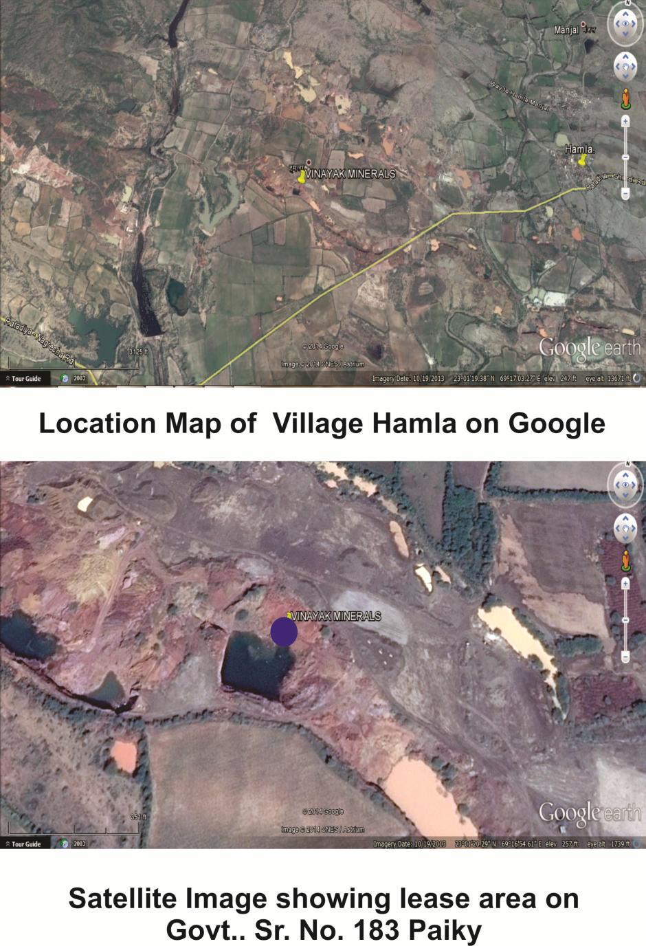
6 approximately Skilled labours-3 and Unskillled-10 to 15 labours will be on project site. 4.0 Project Description : 4.1 Type of project including interlinked and interdependent project if any : The mining of Bentonite is carried out by opencast manual method. No other material is interlinked with this mining work as the project is mineral specific. 4.2 Location (map showing general location, specific location and project boundary & project site layout) with co-ordinates : The area has been marked on Google map including the mining lease location. This comprises the mining lease near village : Satapar, Taluka : Kalyanpur, Dist : Devbhumi Dwarka of Gujarat location of the mining lease is as under 6
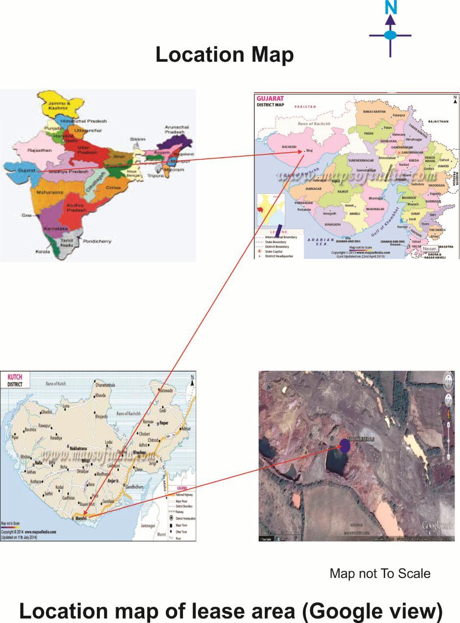
7 7
8 The geographical location of the project is as follows : Latitude (N) 21 58'37.38" Longitude (E) 69 19'8.97" 4.3 Details of alternate sites, considered and the basis of selecting the existing site, particularly the environmental considerations gone into should be highlighted : There is no other alternative sites. 4.4 Size or magnitude of operation : "B" category manual mining method. In this area the Bentonite occurs in form of bed. The mineral reserves have been estimated by plan area method. Based on the experience and the estimated reserves have been classified in to proved, probable & possible reserves The plan area has been calculated from the surface geological plan. The average plan area has been multiplied by thickness of mineral and then multiplied by the bulk density. This gives the geological reserves of mineral which is then further multiplied by recovery factor for this area. 4.5 Project description with process details (a schematic diagram/flow chart showing the project layout, components of the project etc. is given below: The Bentonite deposit in the area existing for mining occurs below a thin cover of soil of thickness 0.10 m as overburden. Manual opencast mining with the help of hammer is suitable for mining of such type of deposits. Bentonite ore will be excavated by manual open cast method. Crowbars pick axe and hammers will be utilized. Besides above, one low headwater pump will be also utilized for dewatering of working pits if necessary. Drilling and blasting will not be required. Rest part about of the lease area is reserved for green belt and mined out part will be used as water reservoir which will create positive impact on Environment. 8
9 Schematic diagram Open cast mining Site preparation Pole marking and fencing OB removal Digging ore by manual Transported to the end use 4.6 Raw material required along with estimated quantity, likely source, marketing area of final products. Mode of transport of raw materials And finished products : N.A. 4.7 Resource optimization / recycling and reuse envisaged in the project. If any, should be briefly outlined : Resources are exploited optimistically, waste dumps will be reused for land fills and rehabilitation. 4.8 Availability of water its source, Energy/power requirement and source should be given : Water to prevent dust pollution and domestic consumption is about 3.0 KLD./day and the source is open well and tanker supply. 4.9 Quantity of wastes to generated (liquid and solid) and scheme for their Management/disposal : As per the mining plan solid waste is to be stored and reused for pit filling Schematic representations of the feasibility drawing which give information of EIA purpose : According to MOEF mining project containing area 5 Ha. are considered in category B 2. Schematic representations of the feasibility is as under. Project Concept and Site selection Form 1 pre-feasibility project report with existing TOR to MOEF (EAC) 9
10 Scoping by SEAC (site visit by sub group of SEAC, if necessary Category B 2 - EIA not required Appraisal and recommended by SEAC Approval by SEIAA Display on the SPCB/UTPCC website & project proponent website 5.0 Site Analysis : 5.1 Connectivity : Mine site is well connected with road transport. Nearest railway station is at Bhatiya Railway Station (13.00 km) in of mine site. State Highway S.H. No.6 (5.40 km). Nearest highway is a National Highway No. 947 Passes in about (55.10 km) Land Form - Land use and land Ownership : The lease area granted is a government land, which is a non-irrigated piece of barren land. The lease area is non-forestland. 5.3 Topography (Google image) : The topography of the terrain Satapar and other villages is marked by low lying narrow laterite ridges with intervening broad flat and undulating valleys gradually sloping towards the coast in the west to south-westerly direction. Being a drought prone area, the rainfall is scanty and hence there are no perennial rivers. The nallas and rivers, which remain mostly dry during major part of the year. The narrow winding ridges normally show a low dip slope towards east-north -east relatively steeper escarpment slope towards west-south-west. 10
11 11
, CRZ.")

12 5.4 Existing land use pattern (agriculture, non -agriculture, forest, water bodies including area under CRZ), shortest distances from the periphery of the project to periphery of the forests, national park, wild life sanctuary, eco sensitive areas, water bodies (distance from the HFL of the river), CRZ. In case of notified industrial area, a copy of the Gazette notification should be given: Nearest Sensitive Area a) Reserve Forest Name Distance from the Project within 10 kms There is no reserve or protected forest within 10.0 km of lease area. b) National Park There is no c) Wild life national park Sanctuary or wild life sanctuary within 10.0 km of lease area. 12


13 d) Eco sensitive areas There is no eco sensitive area within 10.0 km of lease area e) Water source No big water reservoir is within 10.0 km of lease area. The grounder water level is 40 to 100 mt. deep The project is located in seismic zone-iv. There is no flood. cloudburst and landslide reported so far. Seismic zone map 13
14 f) CRZ N.A. There is no C.R.Z. within km periphery of lease area. 5.5 Existing infrastructure : Mine office will be existing in lease area. A well equipped first aid facility will be existing to be available at there. Temporary rest shelter urinal and latrine will be existing. Water will be purchased from nearby tube well from nearby villages. A small water tank will also existing in mine office premises. This will be used for supply of water to drinking purposes. 5.6 Soil classification : Soil of the region falls within Average rain fall zone of mm. The desert- reddish sandy loamy soils. 5.7 Climatic data from secondary sources : in Jamnagar than in summer. The Köppen-Geiger climate classification is As. The average annual temperature in Jamnagar is 25.8 C. The average annual rainfall is 629 mm. 1. Climate graph - Year


15 2. Temperature graph - Year Climate table 15
16 5.8 Social Infrastructure available : The existing project is located at Village : Satapar, Taluka : Kalyanpur. Dist : Devbhumi Dwarka. No big Social Infrastructure available. 6.0 Planning Brief : 6.1 Planning Concept (type of industries, facilities, transportation etc.) Town and country planning development authority classification : No industries and town planning programmers in the existing area. 6.2 Population projection : No Human settlements near project area. 6.3 Land use planning (breakup along with green belt etc) : Details will be given in land use pattern of quarry plan. 6.4 Assessment of Infrastructure Demand (Physical & Social) : There is no large infrastructure demand near to existing area. 6.5 Amenities / Facilities : Not applicable as it is a small project. 7.0 Existing Infrastructure : 7.1 Industrial Area (processing Area) : --NA Residential Area (Non Processing Area) : --NA Green Belt : The plant is following the norms and is in process to developing 33% green belt in lease area. 7.4 Social Infrastructure : N.A. 7.5 Connectivity (Traffic and Transportation Road/Rail/Metro/Water ways etc) : Well connected with Road/Rail. No metro and water ways. 7.6 Drinking Water Management (Source & Supply of water) : Drinking water is procured from open well existing nearby. 7.7 Sewage system : The domestic wastewater treat in the septic tank followed by soak pit. 7.8 Industrial waste management : --NA-- 16
17 7.9 Solid waste management : --NA Power Requirement & Supply / Source : N.A. 8.0 Rehabilitation and Resettlement (R & R) Plan : Policy to be adopted (Central / State) in respect of the project affected persons including home outstees, land outstees and landless labourers (a brief outline to be given) : --NA Project Schedule & Cost Estimates : 9.1 Likely date of start of construction and likely date of completion (Time schedule for the project to be given) : It is an existing project and applied for Ec. 9.2 Estimated project cost along with analysis in terms of economic viability of the project : Project cost No. Particulars Amounts (Rs.) 1 Mining equipments 1,50,000/- 2 Tanker based trolley with Tractor 1,50,000/- Total 3,00,000/- The approximately cost of the project is Rs. 3,00,000 and it is economically Analysis of proposal (Final Recommendation) : Financial and social benefits with special emphasis on the benefit to the This project is creating employment potential for approximately about 10 to 15 local people. 17
18 Thanks 18