Date: March 18, 2016 Meeting Date: March 29, 2016
|
|
|
- Mariah Morris
- 5 years ago
- Views:
Transcription
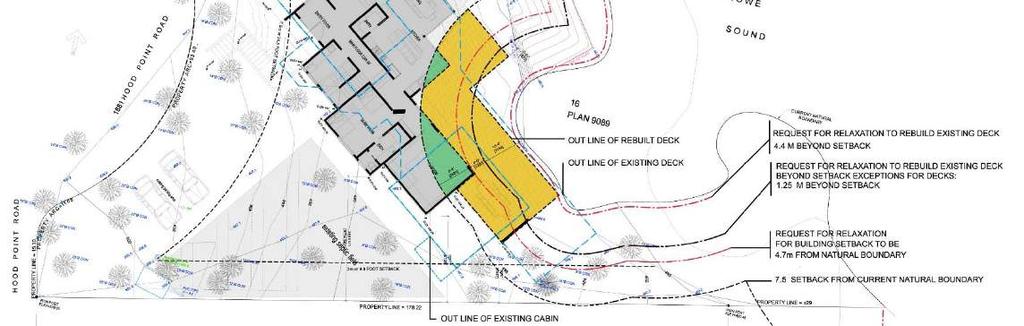
1 To: From: Mayor Skeels and Council Emma Chow, Island Community Planner 1, Planning Date: March 18, 2016 Meeting Date: March 29, 2016 Subject: 1881 Hood Point Rd Sarah Bell & Manny Trinca Lot 16, Block 6, DL 823, Plan 9089 File No. DVP RECOMMENDATION That notice be given that Council will be considering the issuance of Development Variance Permit DVP for the variance of a setback from the sea and the variance of maximum deck projection into a setback for 1881 Hood Point Rd, legally described as Lot 16, Block 6, DL 823, Plan 9089, PID at the April 25, 2016 meeting of Council. That Council authorize staff to give notice for the consideration of issuance of Development Variance Permit DVP in accordance with Section 499 of the Local Government Act to all properties within 100 metres of the legal boundary of 1881 Hood Point Rd, legally described as Lot 16, Block 6, DL 823, Plan 9089, PID PURPOSE The purpose of this report is to provide details regarding a Development Variance Permit application to reduce the setback from the sea and to increase deck projection into a setback. Variance would enable the construction of a residential building to replace an existing non conforming residential building. BACKGROUND The existing house and accessory cabin was in compliance of the setback from the sea at time of construction. However, a recent survey shows a significant shift in the natural boundary of the sea, which places a portion of the house and cabin in the required setback (Figure 2). Also as a result, the existing deck exceeds the allowed projection into a required a setback. The proposed replacement house and deck would largely fit within the footprint of the existing house, cabin and deck. However, and will meet all other setback and height requirements. Rebuilding on existing site would minimize site disturbance, especially to the adjacent environmentally sensitive coastal bluff area.

 Survey at")
2 Figure 1 Air Photo Context Figure 2 Existing Siting Recent survey (2016) Survey at subdivision (1955)


3 Figure 3 Site Plan Figure 3 Existing Siting
4 DETAILS OF APPLICATION Owner/Applicant: Subject Property: OCP Designation: Zoning: Sarah Bell & Manny Trinca 1881 Hood Point Rd RS(e) Rural Residential (0.4 ha), which allow for rural residential use while maintaining the unique amenities and environment of the island. CD4, Area 1 Comprehensive Development 4 Hood Point, which permits the proposed detached dwelling use. This zone allows building up to 7.5 metres of the sea if approved by professionally prepared geotechnical and environmental reports (Sections ). This zone also allows an unenclosed deck to project no more than 1.25 metres into the required setback (Section ). DPA: The property is not located in a Development Permit area. PROPOSED VARIANCE The application requests a variance to the setback from the sea, to allow the new house to be 4.7 metres from the sea. The application also requests a variance to the maximum deck projection to allow the replacement deck to be 4.4 metres into the setback. The existing house is approximately 3.0 metres from the sea and the existing deck projection is almost 7.5 metres into the required setback. INTERNAL REVIEW The application was referred to Public Works, Parks, Fire and Emergency, and Building Inspection. Public Works commented that this property will require a driveway access permit at time of construction and that the applicant should take care not to damage any Hood Point Water System infrastructure during construction. FINANCIAL IMPLICATIONS This application is not anticipated to have financial implications for the municipality. COMMUNICATION STRATEGY Notice of the proposed variance will be mailed to neighbours within 100 metres of the property. Notice will also be posted on the municipal website. Members of the public will be able to provide written comment to Council regarding this application, or appear before Council at the April 25, 2016 meeting.
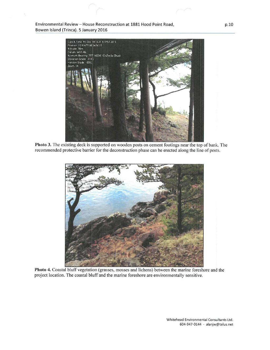
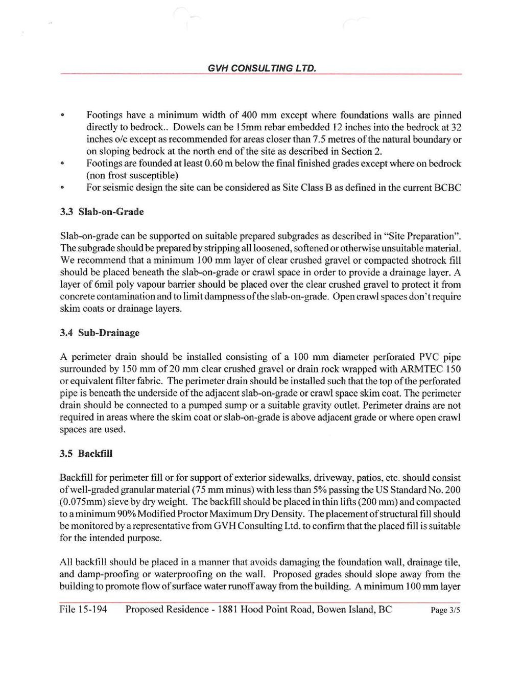
5 OTHER IMPLICATIONS Official Community Plan This variance is supported by Official Community Plan, which allows for historic siting variances: Bowen Island Municipality Official Community Plan Bylaw No. 282, 2010 Objective 57 To permit established residential neighbourhoods to continue historic siting variances from the OCP standards in a manner compatible with the OCP s objectives. Environmental Review An environmental review was completed in January 2016 (Attachment 3). The review found that the proposed development would slightly reduce encroachment toward the shoreline. Also, the findings concluded that the proposed development could be implemented in a manner that would not have adverse impacts on the adjacent coastal zone and marine environment, provided the recommended mitigation measures are adequately employed. Such measures are addressed in the draft Development Variance Permit (Attachment 1). Geotechnical Review A geotechnical review was completed in January 2016 (Attachment 4). The review concluded that the site is considered safe for the proposed development with regards to natural hazards, provided the specified recommendations are followed. Such recommendations are addressed in the draft Development Variance Permit ALTERNATIVES Council has the following options available: 1. That Council authorize staff to give notice that Development Variance Permit application DVP will be considered by Council on March 14, 2016; 2. That Council refer the application back to staff for further information; 3. Other options as determined by Council. Attachments and References: Attachment 1 Draft Development Variance Permit DVP Attachment 2 Draft notice to neighbours Attachment 3 Environmental Assessment House Reconstruction at 1622 Woods Rd, Whitehead Environmental, January 26, 2015 Attachment 4 Geotechnical Report for 1622 Woods Rd, GVH Consulting, January 13, 2015 SUBMITTED BY: Emma Chow Island Community Planner 1 REVIEWED/APPROVED BY: Kathy Lalonde Chief Administrative Officer
6 DEPARTMENTAL REVIEW: Bylaw Services Fire & Emergency Planning Public Library Public Works Recreation & Community Services Finance Corporate Services
7 DEVELOPMENT VARIANCE PERMIT Permit No. DVP Folio No Issued to: Sarah Bell & Manny Trinca Site Addresses: 1881 Hood Point Road The lands affected by and subject to this permit are shown on Schedule "A", Location Map, attached hereto, which forms an integral part of this permit, and are legally described as: LIST OF ATTACHMENTS Schedule A : Location Map Schedule B : Site Plan Schedule C : Temporary Fencing Schedule D : Geotechnical Report Appendix I: Notice of Permit Lot 16, Block 6, DL 823, Plan 9089 P.I.D AUTHORITY TO ISSUE This Development Variance Permit is issued pursuant to Section 498 of the Local Government Act. BYLAWS SUPPLEMENTED OR VARIED Bowen Island Municipal Land Use Bylaw No. 57, 2002 is varied as follows: 1. Section Setback to sea is varied by reducing the minimum setback from the sea from 7.5 metres to the following in accordance with the Site Plan attached hereto as Schedule B : a. 4.7 metres, clear-to-sky from the wall of the house 2. Section Projection of an unenclosed deck into the required setback is varied by increasing the maximum projection from 1.25 metres to the following in accordance with the Site Plan attached hereto as Schedule B : a. 4.4 metres SPECIAL TERMS AND CONDITIONS 1. No variances other than those specifically set out in this permit are implied or to be construed. 2. If a holder of this permit does not commence the construction with respect to which the Permit was issued within two (2) years after the date of the permit, this permit shall lapse.
8 Development Variance Permit DVP page 2 3. Development of the lots shall be undertaken only on the land to which this permit is issued in strict accordance with the Site Plan attached hereto as Schedule B. 4. All new construction shall be substantially in compliance with Schedule B. 5. A driveway access permit shall be required for the proposed development. 6. Before the start of demolition, the owner (or representative), contractors, and an environmental monitor (EM) shall provide written confirmation to the Building Inspector that the following mitigation measures have been reviewed and incorporated in to the overall demolition and construction plan, specifically including methods of communication, location and construction method of a temporary barrier to protect site features and structures to be retained, debris sorting, stockpiling, storage and loading areas. 7. Before and for the entire duration of demolition and construction, maintain a sturdy temporary fence or similar barrier between the work site and the adjacent shoreline top of bank. The conceptual layout of this fence is shown in Schedule C. The fence should be of sufficient height and strength to prevent any accidental spillage of lumber or other debris onto the backshore bank or to the foreshore below. All protective fencing must be approved by an EM before commencement of demolition and again before commencement of construction. Protective fencing may only be removed or relocated with EM approval. 8. If considered necessary by the EM, install additional protection around trunks and exposed roots of existing trees beside the demolition and construction site. For example, this protection can include plastic mesh fencing, covers made of fitted plywood (minimum ½ thick) strapped to the trunks, or equivalent, and (minimum 30 cm thick) layer of wood chips or other suitable material. 9. Ensure that light-weight debris that is susceptible to being moved by wind is removed daily and stored in an appropriate wind-proof location. 10. Ensure that a properly sized and stocked spill kit is available on site for immediate use in the event of a rupture of a hydraulic hose or other spill; and that onsite personnel are familiar with the use of the spill kit s contents. 11. No water that has come in contact with uncured cement shall flow down the bank onto the backshore, foreshore or into the marine environment. 12. All recommendations outlined in the geotechnical report attached as Schedule D shall be followed, including field reviews during construction to confirm that recommendations have been properly carried out. 13. Precautions shall be taken during demolition and construction not to damage existing water main, service line and water meter box along Hood Point Road. GENERAL TERMS AND CONDITIONS 1. This Development Variance Permit is issued pursuant to Section 498 of the Local Government Act.
9 Development Variance Permit DVP page 3 2. This Development Variance Permit shall not vary the permitted uses or densities of land use in the applicable zoning bylaw nor a flood plain specification designated under Section 524(2) of the Local Government Act. 3. Nothing in this permit shall in any way relieve the developer s obligation to ensure that the development proposal complies in every way with the statutes, regulations, requirements, covenants, easements, right-of-ways, and licences applicable to the undertaking. 4. Nothing in this permit shall in any way relieve the developer s obligation to comply with all regulations for construction of structures (including the BC Building Code, BC Plumbing Code and the BC Fire Code) and requirements regarding the provision of on-site services pursuant to the Public Health Act, the Fire Services Act, the Safety Standards Act, and any other provincial statutes. SECURITY DEPOSIT 1. As a condition of the issuance of this Permit, and pursuant to Section 502 of the Local Government Act, the Municipality is holding the security set out below to ensure that development is carried out in accordance with the terms and conditions of this Permit. 2. Should the holder of this permit: a) fail to complete the works required to satisfy the landscaping conditions contained herein, and/or b) contravene a condition of the permit in such a way as to create an unsafe condition, 3. The Municipality may undertake and complete the works required to satisfy the landscaping conditions, or carry out any construction required to correct an unsafe condition at the cost of the holder of the permit and may apply the security in payment of the costs of the works, with any excess to be returned to the holder of the permit. 4. Security Posted: (a) an irrevocable letter of credit in the amount of: $ N/A. (b) the deposit of the following specified security: $ N/A. Note: Bowen Island Municipality shall file a notice of this permit in the Land Title Office stating that the land described in the notice is subject to Development Variance Permit Number DVP The notice shall take the form of Appendix I attached hereto. AUTHORIZING RESOLUTION PASSED BY THE COUNCIL OF BOWEN ISLAND MUNICIPALITY ON THE ## DAY OF month, year. Chief Administrative Officer THIS IS NOT A BUILDING PERMIT

10 Development Variance Permit DVP page 4 SCHEDULE "A" Location Map 1881 Hood Point Rd, legally described as Lot 16, Block 6, DL 823, Plan 9089
11 Development Variance Permit DVP page 5 SCHEDULE "B" Site Plan 4.7 metres to the sea 4.4 metres into setback
12 Development Variance Permit DVP page 6 SCHEDULE "C" Temporary Fencing

13 Development Variance Permit DVP page 7 SCHEDULE "D" Geotechnical Report for Proposed Residence 1881 Hood Point Road

14 Development Variance Permit DVP page 8
15 Development Variance Permit DVP page 9
16 Development Variance Permit DVP page 10
17 Development Variance Permit DVP page 11
18 Development Variance Permit DVP page 12 APPENDIX I Notice of Permit
19 DVP Folio No March, NOTICE TO ADJACENT PROPERTY OWNERS Notice is hereby given pursuant to Sec. 499 of the Local Government Act that Bowen Island Municipal Council will be considering an application for Development Variance Permit DVP for the lands noted below at its meeting to be held Monday, April 25, 2016 at 9:30 AM at 981 Artisan Lane, Bowen Island, B.C. PURPOSE OF THE PERMIT: The purpose of this Development Variance Permit application is to vary a setback requirement for the replacement of an existing residential building at 1881 Hood Point Road, Bowen Island, BC (see Attachment A - Location Map). If issued, the Development Variance Permit would have the effect of varying Section and of the Bowen Island Municipality Land Use Bylaw, No. 57, 2002 as described below. Bowen Island Municipal Land Use Bylaw No. 57, 2002 is varied as follows: 1. Required setback from the sea for development proposal shown in Attachment B is reduced from 7.5 m to 4.7 m. 2. Maximum projection of an unenclosed deck into a required setback for development proposal shown in Attachment B is increased from 1.25 m to 4.4 m. TAKE NOTICE that this is a general description only. A copy of the draft permit can be inspected at the municipal hall (as described below). LANDS SUBJECT TO THE PERMIT APPLICATION: 1881 Hood Point Rd, legally described as Lot 16, Block 6, DL 823, Plan 9089 PID INSPECTION OF THE PERMIT APPLICATION: A copy of the draft Development Variance Permit DVP may be inspected at Bowen Island Municipal Hall, 981 Artisan Lane, Bowen Island, B.C. (open 8:30 a.m. to 4:30 p.m. Monday to Friday, except statutory holidays), from Friday, April 8, 2016 to 9:30 AM Monday, April 25, For further information please contact the Planning Department at COMMENTS RECEIVED IN WRITING BEFORE 4:30 P.M. ON FRIDAY, APRIL 22, 2016 WILL BE PRESENTED TO COUNCIL. Yours truly, Sandi Laudrum, Building & Planning Clerk


20 DEVELOPMENT VARIANCE PERMIT DVP ATTACHMENT A Location Map HOWE SOUND ATTACHMENT B Site Plan
21
22
23
24
25
26
27
28
29
30
31
32
33
34
35
36