COUNTY ENGINEERS ASSOCIATION OF MARYLAND SPRING 2016 CONFERENCE. Conference Center at the Maritime Institute Anne Arundel County, Maryland
|
|
|
- Willis Brooks
- 5 years ago
- Views:
Transcription

1 COUNTY ENGINEERS ASSOCIATION OF MARYLAND SPRING 2016 CONFERENCE Conference Center at the Maritime Institute Anne Arundel County, Maryland Thursday, April 28, 2016
2 Two bridges in Two Months - Accelerated Bridge Construction (ABC) Montgomery County DOT s approach to solving critical challenges on the Whites Ferry Road Bridges Project Girum Awoke, Ph.D, P.E. Chief, Construction Division of Transportation Engineering
3 Outline of Presentation Recognition Project Information/Background Project Purpose and Need Project Elements Schedule and Funding Project Challenges Lessons Learned Resources Questions


4 Project Information/Location One of the main arterials in western, rural MoCo Project Location
5 Project Background Whites Ferry Road - designated as a county arterial road. Bridges located just outside Poolesville Bridge No. M-0187B is located approximately 0.3 miles southeast of the intersection of Waesche Road and Whites Ferry Road Bridge No. M-0189B located approximately 1.3 miles southeast of the intersection of Waesche Road and Whites Ferry Road. The existing single cell culvert is approximately 275 feet northeast of Bridge No. M-0189B and is downstream from the existing bridge.


6 Project Background The project involved: Replacing the existing deteriorated bridges and existing single cell culvert Reconstructing approximately 800 feet of approach roadway Closure of one bridge at a time during bridge construction while maintaining traffic with a detour.


7 Project Background Existing Bridge M-187B Built in foot long single span 24-4 clear roadway


8 Project Background Existing Bridge M-189B Built in foot long single span 23-8 clear roadway


9 Project Background Existing Bridge M-187B structural defects Map cracking with efflorescence in slab soffit; Spalls with exposed reinforcing in slab soffit Vertical crack at joint of west abutment and northwest wing wall Heavy efflorescence at the south end of the east abutment


10 Project Background Existing Bridge M-189B structural defects Spalls in the soffit with exposed and corroded reinforcement, Full height crack in west abutment, Crack and spall in the west abutment, Spall in southeast wingwall, Spall in the east abutment, does not meet FHWA Safety Standards, Spalling on east and west end of north railing
 Provide bicycle compatible roadway Address SWM")
11 Project Objectives Improve structural performance Increase hydraulic performance (10-yr event) Provide bicycle compatible roadway Address SWM needs

12 Project Elements Existing Bridge M-187B Existing vertical profile and horizontal alignments were maintained New 46-foot-span bridge Solid, precast, pre-stressed concrete beams Cast in place deck overlay Beams supported on new RC caps with steel H-piles. Bridge was widened to 30-foot clear roadway (2X11 +2X4 ) Safe on-road bicycling - in accordance with the Master Plan Removed Load restrictions

13 Project Elements Existing Bridge M-189B Existing horizontal alignment was maintained Vertical profile was raised by app. 1 foot at the bridge to reduce the likelihood of flooding New 24-foot-span bridge Solid, precast, pre-stressed concrete beams Cast in place deck overlay Beams supported on new RC caps with steel H-piles. Bridge was widened to 30-foot clear roadway (2X11 +2X4 ) Safe on-road bicycling - in accordance with the Master Plan. Replaced railing Removed Load restrictions


14 Project Elements Culvert Near Bridge M-189B Existing - 4-foot clear opening Proposed 11-6 clear opening Driveway/Access road reconstructed to match new width and road grade Work included providing temporary ped bridge for home owners

15 Project Elements SWM Facilities Bio-swales were constructed alongside both bridges Addressed additional impervious area Constructed as the last item on the project Additional landscaping


16 Project Schedule and Funding Quality Project was funded solely by County funds. The total construction contract was for $2,026,000. At project completion, the total amount paid to the contractor was $1,950,000 including incentive payments for early completion. Scope

17 Project Schedule and Funding It took more than four years to develop project plans, obtain community and stakeholder support, secure funding, acquire land and relocate utilities It took less than two and a half months to complete
 Diverted traffic versus proposed route along rural roads (condition of roads) MCDOT made preventive maintenance such")

18 Project Challenges Construction Duration (summer construction) and Road Closure: MCPS designated school route Complete all construction during the summer break (June 15 August 25) Diverted traffic versus proposed route along rural roads (condition of roads) MCDOT made preventive maintenance such as filling potholes, and trimming tree branches. Project staff also documented existing and developing conditions of the detour route roads through photographs and field notes. In an effort to expedite the construction work, MCDOT also included in the contract an Incentive/disincentive amount of $10,000/day.

19 Project Challenges Impact on Businesses: Several business owners and community members expressed concerns regarding the impact of closing the road MCDOT worked closely with the DED and CE office to develop a work plan that would minimize business impacts The owner of Whites Ferry was concerned with the loss of potential revenue due to the road closure and detour Offered Businesses to develop and submit certified business reports (if they wished to do so) which would then be reviewed by the County s Department of Economic Development A public outreach and communication effort public meetings and public hearings A Variable Message Sign (VMS) was erected at the start of the detour clearly stating that the Ferry was open during construction

20 Project Challenges Impact to Ferry users/commuters: Whites Ferry Road is one of the main arterials that runs through and connects the rural communities in the western part of Montgomery County to the rest of the county In addition, a large number of drivers use the Ferry to cross over the Potomac River on a daily basis. The Whites Ferry has been in service since the 1940s and is the only cable ferry service that carries cars, bicycles, and pedestrians across the Potomac River. Visitors also come to the location for fishing and other water recreation including canoeing.
21 Project Challenges Impact to Ferry users/commuters: It was observed that, in atypical work day, during rush hour, more than 100 commuters utilize the Ferry Most of the commuters work or live in parts of Montgomery County and Loudoun County, Virginia The Ferry provides a convenient, dependable and faster access to these locations MCDOT developed a detour plan that took into account access and travel time to the Ferry Appropriate guiding signs were provided to drivers along the Detour routes
 to mitigate this issue Because the length of the detour route would have caused critical delay during emergency response,")
22 Project Challenges Fire and Emergency: Closing Whites Ferry Road for an extended period of time also raised concerns about emergency response. MCDOT worked closely with the Department of Fire and Rescue Service (MCFRS) to mitigate this issue Because the length of the detour route would have caused critical delay during emergency response, MCDOT installed two 21,000 Gallon Closed Top Frac- Tanks. Minor complaints were received regarding placement of the water supply tanks and available site distance which were immediately addressed by installing additional signs Thankfully, there was no emergency that required the use of these tanks and the tanks did not pose any disruption or cause any accidents
23 Project Challenges Utility relocations: Foot print of the roadway became wider Overhead utilities alongside the road had to be relocated. Despite MCDOT s relentless push for the timely relocation of utilities, communication lines remained in place In order to meet the project timeline and avoid further damage to these bridges, MCDOT allowed work to start while aggressively pushing for the relocation of the utilities After review of the site conditions with the Contractor (Charles J Merlo) it was determined that at bridge 189B the relocation was not needed and the Contractor could proceed while using caution during grading.


24 Project Challenges Utility relocations (Continued): At the 187B bridge, the electrical overhead lines were relocated to their final location but the poles remained in place with the communication lines. Since the top of the poles were cut to a reasonable height, the Contractor again was able to complete their work near but not in conflict with the Verizon and Comcast lines still in place. The contractor had to maneuver his equipment surgically in order to avoid damaging these lines. With close coordination and tact, the bridge elements were installed without damaging any of the utility lines.

25 Project Challenges Change in design requirements (Posttensioning): The slab beams were designed with an old posttensioning requirement that specified a post tensioning force of 120 kips applied once just prior to grouting the rod holes. In the midst of construction, during the shop drawing process, a new directive was issued for a two-step post-tensioning process. This caused some minor delays and confusion during construction. MCDOT also had to pay the Contractor additional money due to the fact that the post-tensioning (Sub Contractor) had to visit the site on multiple occasions to complete the tensioning.
26 Success Factors Community Engagement Cooperative Contractor Effective Communication

27 Lessons Learned Early Utility Coordination Interaction Between Units Persistence


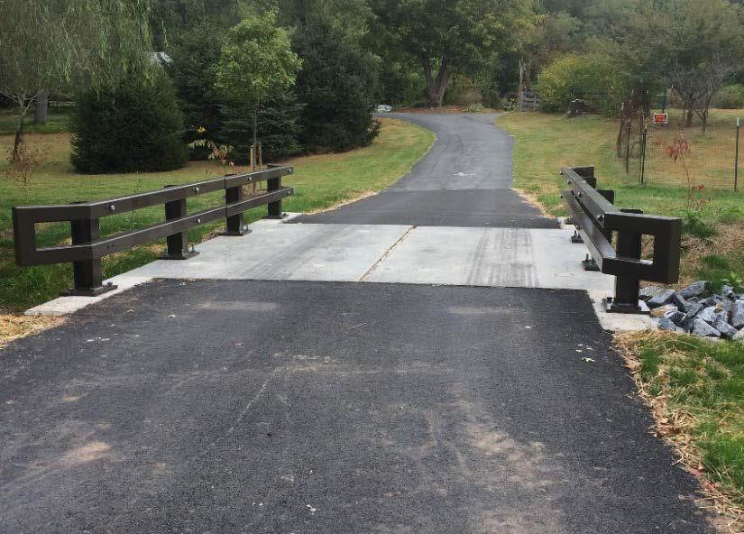
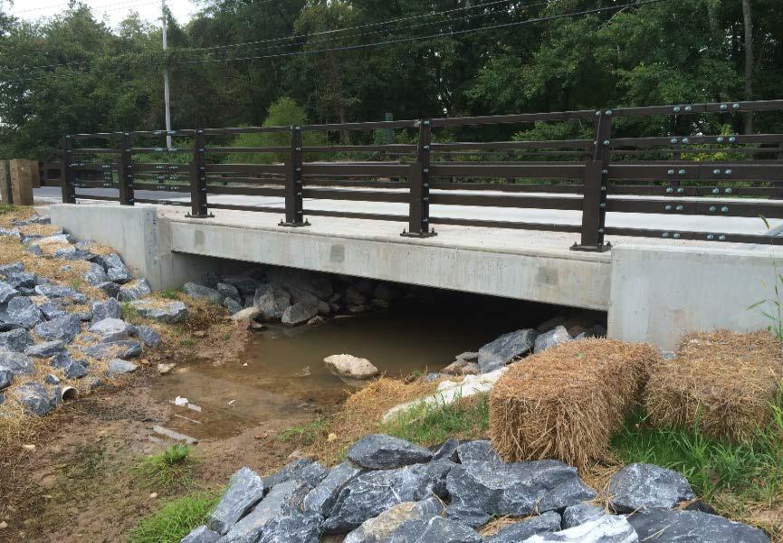
28 Project Photos Completed


29 Project Photos Completed
30 Resources County Home Page: tymd.gov/index.aspx MCDOT: MCDOT DTE Projects


31 Girum S. Awoke, Ph.D., P.E. Tel: