Eastside Transit Corridor Phase 2
|
|
|
- Magnus Lynch
- 5 years ago
- Views:
Transcription

1 Eastside Transit Corridor Phase 2 Community Meeting, June 22, 2016 Page 1
2 Purpose of Tonight s Meeting Page 2 Update on Metro Board directed Technical Study (Nov. 2014) SR-60 Alternative Washington Blvd Alternative Recap of Routing Concepts Construction Methods Break out Groups 2
3 Phases of Project Development Page 3 Initiate Public Meetings Define Alternatives, Alternative Analysis (2009) Public Scoping Draft EIS/EIR (Aug. 2014) Public Comment Period Locally Preferred Alternative Metro Board Directive (Nov. 2014) We Are Here Ongoing Public Participation 3
4 Metro Board Action (Nov 2014) Page 4 Continue Studying SR 60 North Side Design Variation (NSDV) option Address Comments from Cooperating Agencies Environmental Protection Agency (EPA) California Department of Transportation (Caltrans) Southern California Edison (SCE) US Army Corp of Engineers (USACE) Explore feasibility of operating both alternatives Eliminate aerial on Garfield Avenue between Via Campo and Whittier Blvd, and identify a new north-south connection to Washington Blvd 4


5 Page 5 Eastside Phase 2 Study Area in Los Angeles County 5
 3")
 Estimated 64,000 boardings by 2030")
6 Expo Line Extension (Phase 2) to Santa Monica Page mile corridor 7 Stations (4 at-grade and 3 aerial) 3 Park-and-ride lots Frequency - every 12 minutes 46 min trip from Downtown LA to Santa Monica) Estimated 64,000 boardings by 2030 Cost of $1.5 billion 6


7 Page 7 Expo Phase 2 Opening Weekend (May 20-21, 2016) Opening Ceremony 5/20 Free rides 5/20 & 5/21 Events held at all stations free to the public Thousands attended opening weekend events 7


8 Regional Connector Transit Project Page 8 Currently Proposed Operating Plan 1.9 mile underground line in Downtown LA Extend Gold Line from Little Tokyo Station to 7th/Metro Station with 3 new stations 1 trip ride (no transfer): Eastside Gold Line Extension to Santa Monica Azusa to Long Beach Opening year in 2020 $1.4 Billion 8

9 Eastside Phase 2 Study Area Page 9 9
10 Alternatives Studied in 2014 Draft EIS/EIR Page 10 Draft EIS/EIR Alternatives: SR Miles, 4 Stations (all aerial) 16,700 Average Daily Boardings (2035) Washington Blvd (Garfield) 9.3 Miles, 6 Stations (3 aerial, 3 at-grade) 19,900 Average Daily Boardings (2035) Eastside Phase 2 Funding LRTP: $2.4 Billion, 2035 Delivery Date Measure R: $1.27 Billion (2008$) 10

11 Alternatives Studied in 2014 Draft EIS/EIR Page 11 Aerial configuration no longer under consideration 11


12 Page 12 SR-60 North Side Design Variation (NSDV) Alternative 12


13 SR-60 North Side Design Variation Segment Page 13 Greenwood Av LRT crossover affects the ability to widen SR 60 to full standard + HOV lanes OII Landfill Superfund Site Market Place Drive Need to move the crossover further east to avoid visual impact to Market Place Development Paramount Blvd Need to modify LRT column location to avoid conflict with Caltrans ramp improvements Need to raise SCE wires to provide clearances SR 60 NSDV LRT Alternative Monterey Park Market Place OII Landfill Superfund Site 13

14 New N/S Connection to Washington Blvd Page 14 14

15 Potential Washington Blvd Routing Concepts Page 15 Initial Washington Blvd Routing Concepts Evaluated/Screened Concepts 15


16 Feedback From Stakeholders Page 16 Corridor Opportunities Key Challenges Arizona/ Telegraph Economic revitalization on Whittier Corridor Preserving on-street parking (between 3 rd and Whittier) Atlantic Transit Oriented Communities (TOC) in Atlantic and Whittier Corridors Traffic/circulation impacts with at-grade LRT Garfield (Underground) Helps revitalize south Montebello along Washington Blvd Property impact during and after construction of subway portals; Sewer line and storm drain issues 16
 Queuing Issues (if any) Developed future traffic data (2040) Initial Findings: Traffic heavier on Atlantic (peak and midday) Additional safety and operations analysis are")
17 Initial Grade Crossing Analysis Page 17 3rd St Collected new traffic data for 33 Intersections Conducted field observations for: Driveways and access conditions School crossings (6) Potential visibility issues (if any) Queuing Issues (if any) Developed future traffic data (2040) Initial Findings: Traffic heavier on Atlantic (peak and midday) Additional safety and operations analysis are recommended for 8 locations (25%) Map of Study Locations 17
18 Page 18 Washington Blvd Alternative What s Next? Grade Crossing Analysis Siting and Design of Tunnel Portals (if applicable) Station Planning Right-of-Way Impacts Utility investigations Engineering studies in support of new cost estimates 18

 (Typically used for a 1-mile or longer segment) 19")
19 Page 19 Two Primary Methods of Underground Construction Cut & Cover definition: shallow tunnel dug from the surface, then covered Bored Tunnel definition: deep tunnel burrowed via a boring machine Cut & cover construction (Mariachi Plaza) Tunnel Boring Machine (TBM) (Typically used for a 1-mile or longer segment) 19
20 Stage 1 Install Soldier Piles Page 20 Cut and Cover Phasing Implement Traffic Control Drilling of Soldier Piles Surface Disruptions Potential partial & complete street closures Duration (Months) 3-4 months for a station 20
21 Stage 2 Install Decks Page 21 Cut and Cover Phasing Close Street Excavate 12 below Surface Install Deck Beams Support Utilities Install Decking Surface Disruptions Potential complete street closures Duration (Months) 2-3 months for a station 21
22 Stage 3 Excavate Station from Surface Page 22 Cut and Cover Phasing Detour Traffic Excavate Trench Install Struts Surface Disruptions Potential partial & complete street closures Duration (Months) 2-3 months for a station 22
23 Page 23 Stage 4 Excavate Station from Below Surface Cut and Cover Phasing Excavate Below upper strut Install Lagging Surface Disruptions Occasional partial street closures Duration (Months) 6 months for a station 23
24 Page 24 Stage 5 Excavate Lower Levels of Station Cut and Cover Phasing Install Struts Excavate Middle strut Install Lagging Surface Disruptions Occasional partial street closures Duration (Months) 6 months for a station 24

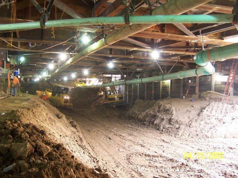
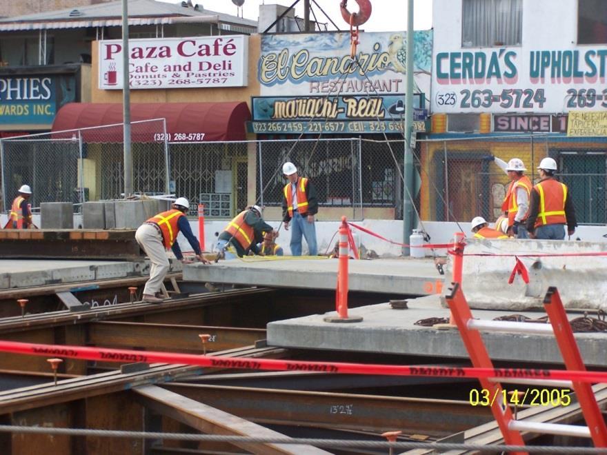
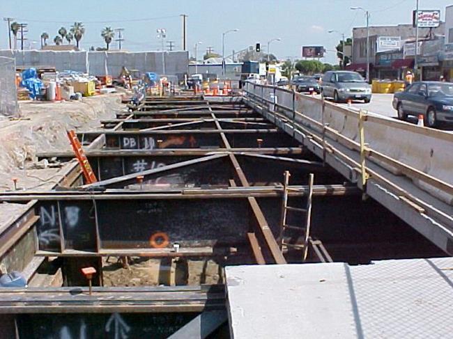
25 Page 25 Cut & Cover Construction (Mariachi Plaza) 25

26 Tunnel Boring Machine (TBM) Launch Pit at Metro Gold Line Little Tokyo Page 26 Steps to launch TBM: 1.Space Need (4-6 acres) 2.Demolition and utility relocation 3.Dig Launch Pit 4.Install piles, struts and decking 5.Lower TBM into position Tunnel Boring Launch site at 1 st St. & Alameda St. 26

27 Page 27 Tunnel Boring Machine for Metro Crenshaw/LAX Tunnel boring machine (TBM) Launch Site Cross Section Cut & Cover Construction at Launch site Construction Fence Deck Panels Deck Beam Struts Piles Off-Street- TBM Launch Site / Construction staging Tunnel Boring Machines
28 Page 28 Regional Connector Project Tunneling Duration Activity Pre-construction Site preparation Cut & cover at Portal & station 2nd St TBM Tunnel Duration (Months) 4-6 months months months months 28


29 Dodger Stadium ~12 acres Evergreen Cemetery ~ 6 acres Space Needed to Launch TBM: 4 to 6 Acres Page 29 Dodger Stadium ~12 acres Staples Center ~ 5.5 acres About 6 acres About 5 acres 4-6 Football Fields 1 acre = 1 football field
 ROW acquisition Major traffic disruptions along alignment for extended durations Traffic diversion to parallel streets Major disruption to access to residences and")

30 Page 30 Cut & Cover/TBM: Advantages and Disadvantages Tunneling Method Advantages Disadvantages Cut & Cover Potentially less noise/vibration and visual impacts after temporary decking is installed (compared to at-grade construction) ROW acquisition Major traffic disruptions along alignment for extended durations Traffic diversion to parallel streets Major disruption to access to residences and businesses along entire alignment for extended durations Noise and visual impacts until temporary decking is installed TBM Less construction activity on surface Avoids most typical utilities Can improve schedule Major ROW acquisition for large staging area needed for launching/extracting TBM Similar disruptions to Cut and Cover but only at station and launching/extracting TBM and for shorter period of time Typically used for a 1-mile or longer segment 30
31 Interactive Discussion Page 31 Join a discussion group Nominate a group spokesperson Share what you discussed Comments and Questions 31
32 Topics to Discuss Page 32 Based on what you ve heard, which corridors are most promising? Why? Where should stations be located? Why? What do we need to know? 32
33 Next Steps for Technical Study Page 33 Continue stakeholder/community outreach meetings Incorporate feedback in project planning Continue technical analysis Present findings of Technical Study to Metro Board (early 2017) 33 33

34 Page 34 Eastside Transit Corridor Phase 2 Q&A 34