ADAMS COUNTY ROAD STANDARDS
|
|
|
- Ralf Reynolds
- 6 years ago
- Views:
Transcription
1 ADAMS COUNTY ROAD STANDARDS June 19, ADAMS COUNTY PUBLIC WORKS 210 W. Alder Ritzville, WA (509)
2

3
4 1.00 GENERAL CONSIDERATIONS 1.01 APPLICABILITY These Standards shall apply to all new construction of public and private roads in Adams County. The Standards are applicable to both public and private work on roads within Adams County. In case of any ambiguity or dispute over interpretation of the provisions of these Road Standards, the decision of the County Engineer shall be final. Prior to the issuance of a building permit, a lot, parcel, or tract of land shall have access by a driveway, private road, or public road DEFINITIONS 1. Clear Zone is used to designate the unobstructed area provided beyond the edge of the traveled way for the recovery of errant vehicles. 2. County Engineer is the Adams County Engineer, having authorities specified in RCW and 36.80, or an authorized representative. 3. Cul-de-sac is a short street having one end opened to traffic and ending with a vehicle turnaround, either permanent or temporary. 4. Driveway shall mean private driveways that provide primary vehicular access from a public or private road up to three lots. 5. Driveway Approach shall mean any area, construction or facility between the public or private roadway and private property to provide access for vehicles from the roadway to serve up to two lots, tracts, or parcels, except as provided herein. 6. Engineer shall mean Professional Engineer licensed by the State of Washington. 7. Established County Road shall mean a road that has been accepted by Adams County for maintenance with public funds. 8. Established Grade shall mean the profile and cross-sections approved by the County Engineer. 9. Level of Service (LOS) is a qualitative measure of traffic flow. Six levels are defined as A through F with A being the best operating conditions and F being the worst. 10. Private Road or Lane shall mean privately owned vehicular access route serving more than one lot, parcel, or tract which does not have frontage on a public road right-of-way. Adams County does not maintain private lanes. 11. Project shall mean the design and construction of infrastructure associated with land development activities. 12. New Construction shall mean the construction of a new roadway or structure on a new alignment. It also means the upgrading of an existing roadway or structure by the addition of one or more continuous traffic lanes. Adams County Standards 2
5 13. Public Road where used in these standards, shall mean an established County road. 14. Record Drawings or As Builts, shall mean the plan set, which is certified to contain a true and accurate representation of the actual field, conditions for the project during construction, or upon completion of construction. 15. Road and Street will be considered interchangeable terms in these Standards. 16. Roadways shall mean the portions of a street, including shoulders but excepting concrete gutters, designed or ordinarily used for vehicular travel. 17. Standards shall mean the requirements contained in the Adams County Road Standards. 18. Sponsor means a person who undertakes to create a division of land. 19. Sponsor Engineer Design phase The Design Engineer who directly prepared plans and calculations, or who directly supervises the preparation of project plans and calculations. The Design Engineer seals, signs and dates the plans and calculations, certifies that they meet the required standards, and approves the plans for construction. Also known as the Engineer of Record, the DesignEngineer may also act in capacity of the Construction Engineer. Construction phase - The Construction Engineer who directly inspects, or who directly supervises the inspection of the construction of a project to ensure compliance to the plans and standards specifications. The Construction Engineer maintains and certifies the Record Drawings. TheConstruction Engineer may have also acted in the capacity of the DesignEngineer. 20. Surveyor shall mean a Professional Land Surveyor licensed by the State of Washington. 21. Traffic Barrier shall mean a barrier oriented parallel or nearly parallel to the roadway. The purpose of these devises is to contain or redirect errant vehicles from hazards within the clear zone. 22. Traffic Impact Study shall mean a report that documents a study of traffic conditions before and after construction of a proposed development. It addresses any deficiencies in the transportation system, either current or after development, and proposes recommended mitigation to correct those deficiencies. 23. Traveled way is comprised of the through traffic lanes. It is the portions of street designed or ordinarily used for vehicular travel excluding shoulders, medians, bicycle lanes, or exclusive turn lanes. Adams County Standards 3
6 1.03 RESPONSIBILITY TO PROVIDE All development shall include provisions for construction or improvement of roads according to these Standards. The Sponsor s Engineer shall consider the following guidelines in planning transportation systems. 1. Adequate vehicular access should be provided to all parcels of land 2. Local access roads should be designed to minimize through traffic movements and excessive speeds. 3. Street patterns and names should be logical, consistent and understandable to satisfy the needs of emergency and delivery vehicles. 4. Traffic generators within the project should be considered and the street system designed appropriately. 5. The Sponsor s Engineer should consider bordering arterial routes and should provide design continuity. 6. No direct residential lot access shall be allowed to urban principal and minor arterials. 7. When a subdivision has the cumulative effect of creating a total number of lots, parcels, or tracts served by an access road equal to or greater than the number of units shown in the following table, the Sponsor shall provide an additional access road into the development to serve fire district vehicles. The location of the additional access road shall have the concurrence of the fire district. If the location and layout of the development, in the opinion of the fire district authorities, causes a concern for safety, an additional access road may be required regardless of the values shown in the following table. Setting Units Apartments/Attached Housing* 20 Single Family Residental 10 *Privately owned access roads may be closed with a gate. No locking gates will be allowed without approval of the fire district. 8. The Sponsor s Engineer shall consider ease of maintenance when designing public and private roads REFERENCES These Standards are intended to be consistent with the following references, as amended: 1. City and County Design Standards for the Construction of Urban and Rural Arterial and Collectors adopted February 10, 1994 per RCW and RCW Adams County Subdivision Ordinance Resolution No Washington State Local Agency Guidelines. 4. A Policy on Geometric Design of Highways and Streets published by the Adams County Standards 4
7 American Association of Highway and Transportation Officials (AASHTO). 5. Highway Capacity Manual (Special Report 209) published by the Transportation Research Board, National Research Council. 6. Roadside Design Guide published by the American Association of Highway and Transportation Officials (AASHTO). 7. Adams County Comprehensive Plan. 8. Adams County Zone Code 9. WSDOT Design Manual 1.05 Not Used 1.06 STATE SPECIFICATIONS AND PLANS Except where stated in these Standards, design and construction shall conform to the current editions of the following Washington State Department of Transportation publications, as adopted by Adams County. 1. Standard Specifications for Road and Bridge Construction. It will be referred to as the Standard Specifications. 2. Standard Plans for Road and Bridge Construction DEVIATIONS AND REVIEW OF DECISION 1. Deviations from these Standards may be granted by the County Engineer in writing upon written evidence from the Project Sponsor that the proposed deviation does not conflict with or modify a condition of approval and, 2. Deviations are based upon sound engineering principals, and 3. Deviations meet requirements for safety, function, appearance, and maintainability. Desired deviations must be approved before road plans are accepted for development. Deviations must be approved before commercial building permits are issued. The County Engineer may apply conditions to the approval of design deviations. The conditions may not have been required in the preliminary plat approval Not Used 1.10 COMPLIANCE REVIEW In the event an Engineer or Surveyor submits plans, calculations, or record drawings that are not in compliance with these Standards, the County Engineer may refer the case to the Director of Public Works for consideration. Decisions of the Director of Public Works may be appealed to the Board of County Commissioners. Failure to comply with these Standards will be cause for withholding or withdrawing approval of permits, plats, forfeiture or bond, and/or other penalties as provided by law. Adams County Standards 5
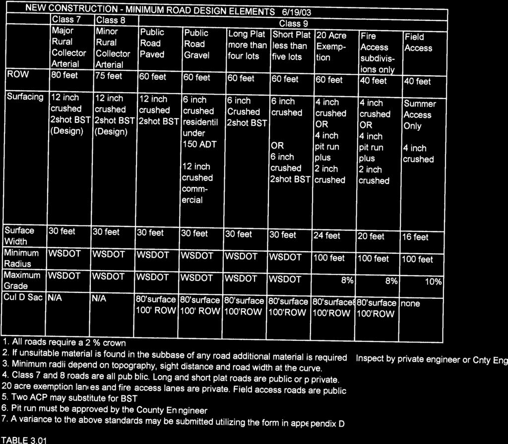
8 1.11 ROADWAY TYPES The roadway types and widths of County roads are shown in Table 3.01 and in the Standard Plan sheets entitled Adams County Design Templates ROADWAY CLASSIFICATIONS 1. RURAL ARTERIAL SYSTEM A. Major Collector Arterial- Class 07, These routes (1) serve County seats on arterial routes, larger towns not directly served by the higher systems, and other important traffic generators, such as consolidated schools, shipping points, County parks, important mining and agricultural areas: (2) link these places with nearby larger towns or cities, or with routes of higher classification; and (3) serve the more important intracounty travel corridors. B. Minor Collector Arterial-Class 08, These routes should (1) be spaced at intervals consistent with population density to accumulate traffic from local routes and bring all developed areas within reasonable distance of collector roads, (2) provide service to remaining smaller communities, and (3) link the locally important traffic generators with surrounding areas. 2. ACCESS ROADS CLASS 09 Access roads allow direct access to abutting land and connections to the higher order systems. They offer the lowest level of mobility. Access roads should be signed to discharge service to through-traffic movement. A. Industrial/Commercial Access -These local access roads abut manufacturing facilities, stores, dense multiple family dwellings, commercial sources, office and professional buildings. B. Residental/Farm Access Theses local access roads provide access by though roads, loops roads and cul-de-suc roads to homes and farms connecting to a collector arterial or other residential or farm access streets. C. Primitive Roads- Primitive roads are existing, rural, low volume, (under 100 ADT), unpaved, access roads and are designated as such by a sign at all places where the primitive road portion begins or connects with a highway or road other than a primitive road. This classification is for signage only and does not affect the level of maintenance. D. Field Access Roads- These summer roads are not fully maintained roads. Maintenance occurs as needed, on an irregular basis within systems-wide Adams County Standards 6
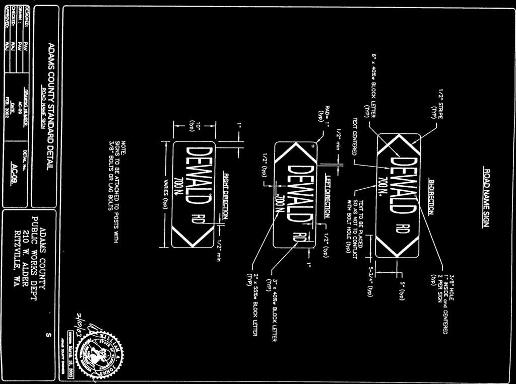
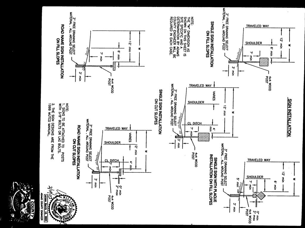
9 priorities, only during the summer months. Snow removal is not performed on these roads. Field access roads are usually not constructed to regular design standards and do not have warning nor regulatory traffic signs. E. Long Plat Roads These roads provide access within a long plat (more than 4 lots) and are paved with a 2 shot class A Bituminus surface treatment. These roads may be a public road or private lane however, the standards are the same for either. F. Short Plat Roads- These roads provide access within a short plat (less than 5 lots). They may be gravel or paved. If the road connects to a paved road then the short plat road must at least be paved to the right away line. If it is connected to a gravel road then it may be graveled. These roads may be a public road or private lane however the standards are the same for either AC EXEMPTION ACCESS LANES These private lanes are meant to provide access to parcels created under the 20 acre plat exemption. The adjoining landowners are fully responsible for all maintenance. The County will perform no maintenance Not Used 1.15 Not Used 1.16 FIRE ACCESS LANE These private lanes are meant only to provide an all weather emergency secondary access. They are not owned or maintained by the County but rather by the landowners served by the lane PRIVATE LANE (Private Road) Private lanes are owned and maintained by the landowners served by the lane. The purpose and standards are the same as Public Road classification ROAD NAMES The Sponsor may suggest road and lane names within a development as long as they do not line up with an existing County Road. Road Names will be reviewed by the Planning Director and modified as necessary to conform to regulations. All roads located outside of incorporated areas shall be called Roads except: 1. A dead-end road or cul-de-sac under 200 when not an extension of an existing roads or a continuation of any future road shall be called a Court. Adams County Standards 7
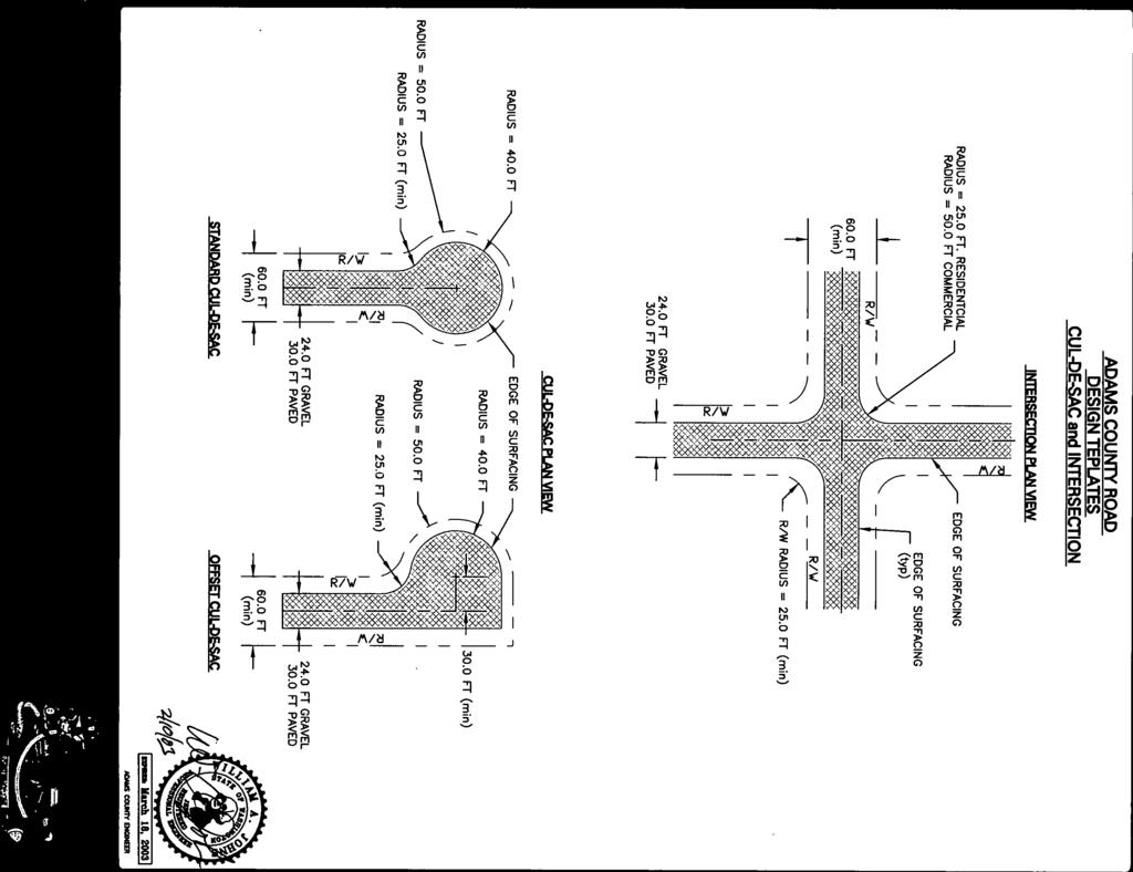
10 2. A private road or driveway with two residents shall be called a lane Not Used 1.20 LEVEL OF SERVICE The County Engineer has established acceptable Levels of Service (LOS B ) for traffic at Adams County intersections. Levels of Service are used in determining the impacts on the road system by land development proposals Not Used 1.40 SEVERABILITY If any part of the Adams County Road Standards as established by ordinance shall be found invalid, all other parts shall remain in effect NEW CONSTRUCTION DESIGN STANDARDS 3.01 COUNTY ARTERIAL ROADS Standards for construction of new arterial roads and reconstruction of existing arterial roads within Adams County shall follow the criteria shown on Tables 3.01 Arterial Street Design Standards and Table A Policy on Geometric Design of Highways and Streets (AASHTO) shall govern all design elements not shown in these standards COUNTY ACCESS ROADS AND LANES Standards for construction of new access roads, lanes and reconstruction of existing access roads and lanes within Adams County shall follow the criteria shown on Table 3.01 New Construction-Minimum Road Design Elements and Table 3.02 A Policy on Geometric Design of Highways and Streets (AASHTO) shall govern all design elements not shown in these standards. 303 Not Used 3.04 INTERSECTIONS The minimum return radius at intersections on an arterial road shall be twenty five feet. Private curbed roads 24 feet or narrower shall have return radii of 25 feet. The minimum return radius at all other intersections shall be twenty feet. Larger radii may be required where truck traffic is a significant factor. Where trucks are a significant factor, the County Engineer shall decide the size of the return radii. All intersections shall be designed at right angles to the intersecting road, where possible. If a right angle is not possible, the skew angle shall not vary more than 15 degrees from a right angle. At four legged intersections, opposite legs shall lie on a straight alignment Adams County Standards 8
11
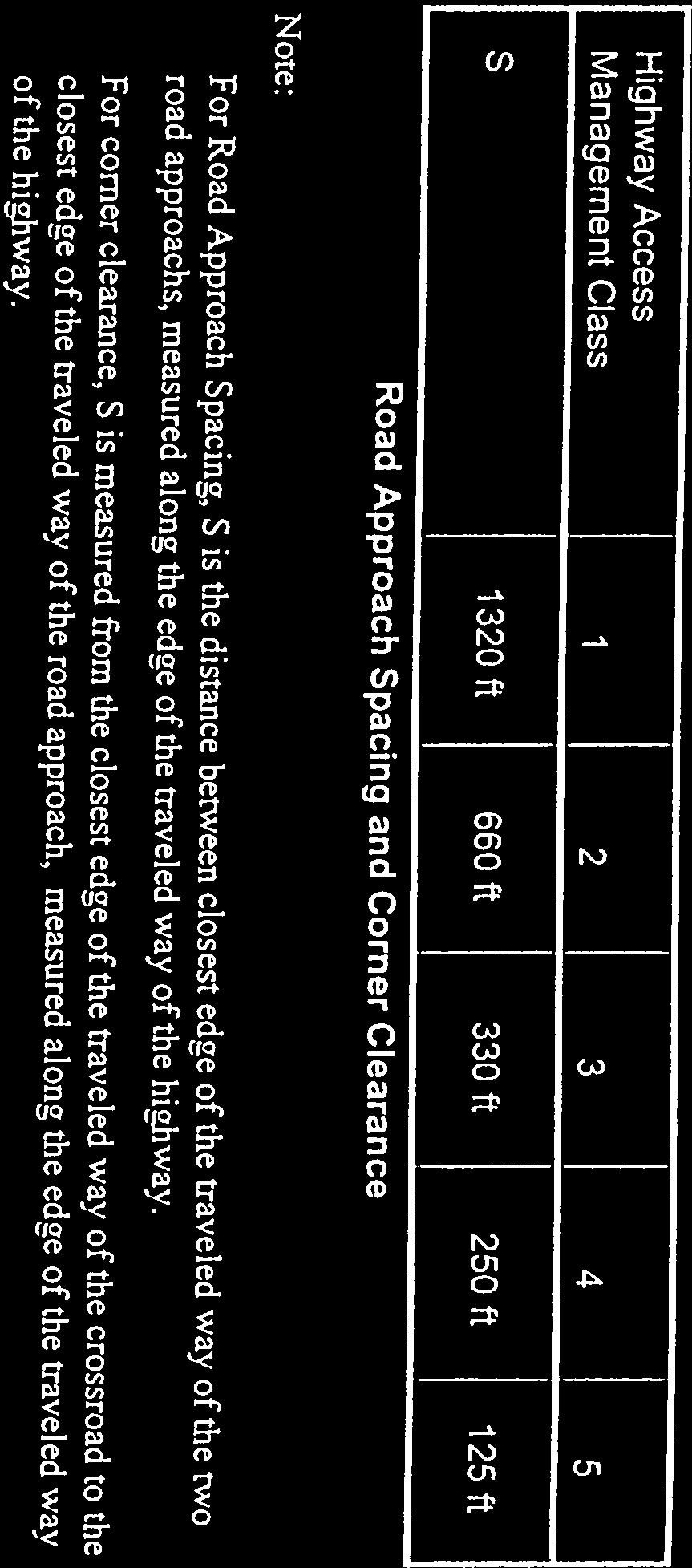
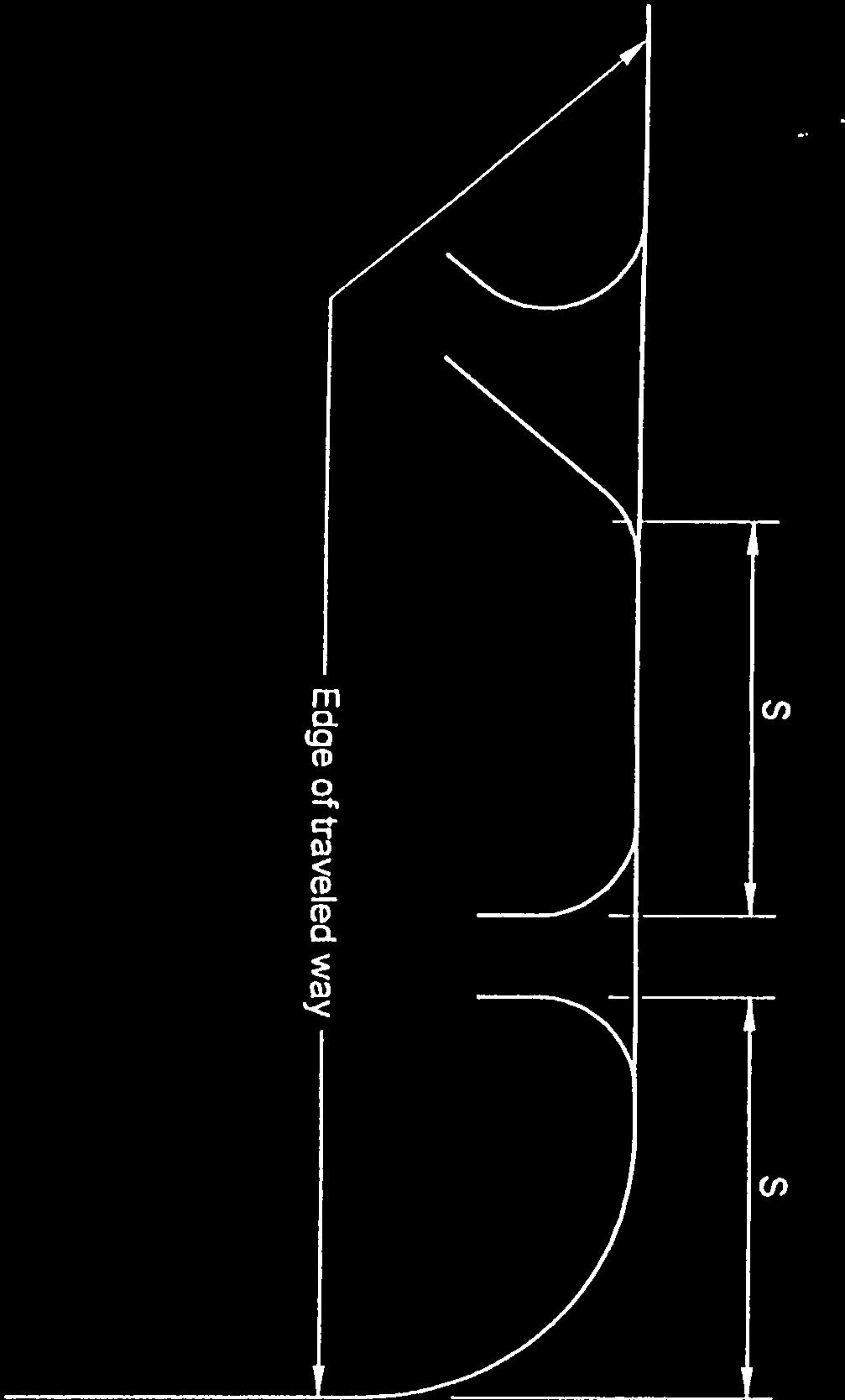
12 where possible. The minimum distance between intersections on a County road shall be as shown in Appendix A. Distances are measured from the centerline of the intersecting road to the centerline of the next intersecting road. The cross slope of the higher priority roadway shall be extended through the intersections. The grade of the crossroad shall be adjusted to meet the cross slope of the higher priority roadway. The road approach area is where vehicles store while waiting to enter an intersection, and shall be designed with a nearly flat grade. For public or private roads, the road approach area at a stop-controlled intersection (i.e. stop sign, yield sign) shall have a downgrade approaching the intersection of no greater than 2.0 percent. An upgrade approaching the intersection shall be no steeper that 4%. The minimum length of the road approach as measured from the edge of the traveled way is to be in accordance with Table For any road classification not listed in Table 3.02, the County Engineer may require a traffic analysis to determine the road approach length. Average Daily Minimum Road Approach Length Traffic (ADT) of Higher (2% Maximum Downgrade and 4% Priority Road maximum upgrade) Local Access Streets Collector Arterial (2) & Private Roads (1) ADT< FT 50FT 1000< ADT<5,000 50FT 75FT TABLE Not Used 3.07 SLOPES Embankment slopes constructed with native soil or imported soil shall not be steeper than in inclination of 2:1 for slopes that are 10 feet or greater in height measured vertically from the slope toe to the crest. Embankment slopes less than 10 feet high may be constructed at inclinations not steeper than 1.5:1 provided proper fill placement and compaction criteria, and erosion control are called for in the contract documents. Steeper embankment slopes for any embankment height, including mechanically stabilized earth Adams County Standards 10
13 slopes, may be permitted by the County provided the Sponsor s Engineer can demonstrate that the factor of safety against slope instability (global and internal) is not less than 1.3, and that erosion potential of the slopes will be properly mitigated during construction. Cut slopes in competent native soils shall not be steeper than an inclination of 1.5:1 unless a license engineer qualified in soils testing and analysis, prepares and signs a report. Erosion mitigation shall be included in the contract documents. The Sponsor s Engineer shall provide a space between the catch point of the slope and the right of way line on shouldered roads with side slope of 3:1 or steeper. This space provides for utility poles, fences, etc. The minimum distance of this space shall be five feet. The Terrain or design features of a road may require slope, wall or drainage easements beyond the right of way line. The County Engineer shall require easements or acquisition of right of way. Guardrail may be required RIGHT OF WAY The road right of way width shall be as shown on table Wider right of way may be required to contain the road prism and within the Othello planning area CONNECTIONS OF STATE HIGHWAYS AND NEW COUNTY ROADS The Sponsor shall prepare and submit to the County Engineer a design proposal, acceptable to the Washington Department of Transportation (W.S.D.O.T.), of the proposed state highway-county road intersection. W.S.D.O.T. approval of the proposed design must be received before the filing of the final plat. Improvements to the state highway are the responsibility of the Sponsor. The Sponsor may either construct the improvements or furnish to the County Engineer a bond to cover the cost of such improvements. The County Engineer and W.S.D.O.T. will decide the amount of the bond Not Used 3.12 STANDARD ROAD AND TRAFFIC CONTROL SIGNING The Sponsor shall be responsible for the installation of all permanent traffic control devices, such as, signs, striping and marking. He/she shall submit a signing and striping plan for approval. The plan shall show the types and locations of all traffic control devices, such as, signs, stripes, marking and delineators to be installed on public right-of way. Traffic control devices shall conform with the Manual on Uniform Traffic Control Devices. If the permanent traffic control devices are not installed in a timely manner the Sponsor shall be given a 30 day notice after which time the County will furnish and install the devices and bill the Sponsor based on the actual cost for labor, equipment Adams County Standards 11
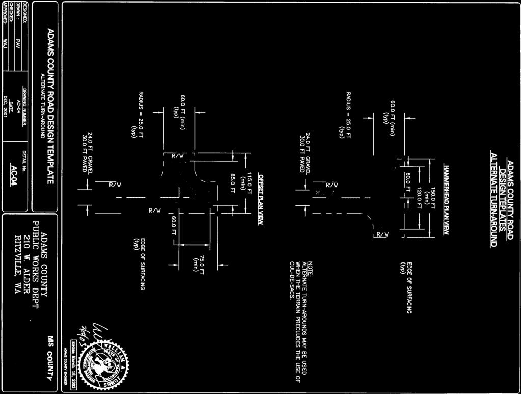
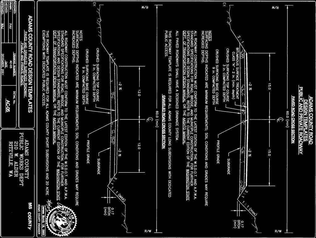
14 rental, and materials. If the absence of critical safety devices such as stop signs is causing a present endangerment to the traveling public, the County will immediately furnish and install the devices and bill the Sponsor for the work Not Used 3.14 TRAFFIC BARRIERS Traffic barriers shall be provided as specified in the Washington State Department of Highways Design Manual. A roadway cross section shall be submitted to assure proper barrier location. The barrier shall conform to Washington State Department of Transportation Standard Plans for guardrail and concrete barrier CLEAR ZONE The term clear zone is used to designate the unobstructed area provided beyond the edge of the traveled way on public road for the recovery of errant vehicles. 1. On shouldered roads, rigid objects shall be placed no closer to the traveled way than clear zone distance derived by using tables and the methods described in the current edition of the Roadside Design Guide, AASHTO. Within the clear zone, all hazards shall be protected by traffic barrier ROAD SURFACING REQUIREMENTS The road requirements are as shown on table Paving may be class A plant mix or a class A bituminous surface treatment (B.S.T.). The B.S.T. shall consist of no less that two applications of oil. The gravel thickness shall be designed according to good engineering practices considering the quality of the underlying soil. The design method shall be subject to approval by the County Engineer. In no case shall the gravel thickness be less than as shown in table A crushed rock surfacing may be used in some cases as shown in table Table 3.01 represents minimums. Soil conditions may require additional base and/or wearing courses CUL-DE-SAC Dead-end public roads shall have a cul-de-sac constructed at the end. Cul-de-sacs are shown on the Standard Plan sheet intitled Cul-de-Sac Public Roads. Cul-de-sacs shall have a minimum surfacing radius of 40 feet Not Used Adams County Standards 12
15 3.22 PRIVATE ROADS A private road is a privately owned vehicular access route serving lots, parcels or tracts which do not have frontage on a public road right of way. Private roads must meet the same standards as public roads. The traveled way of a private road shall be designated as a fire lane under the Uniform Fire Code, as amended. Adams County will not perform an in-depth review of private road plans, inspect the construction of private roads, or maintain private roads. The intersection with a County Road will be reviewed and inspected. All private roads shall be called lanes. Private roads may be permitted when: 1. The road is within a subdivision approved according to the Adams County subdivision code. 2. A title notice has been approved and recorded with the County that provides for maintenance of the private roads and associated parking areas by the owners in the development, and A. Provision is made for the road to be open for emergency and public vehicle use. B. The title notice shall include language indicating that the county is not responsible for maintenance of the private road, and C. The private roads will not obstruct public road circulation. Private road design plans, drainage studies, drainage plans and appropriated calculations shall be submitted by the Sponsor to the County Engineer prior to construction of the road. All submittals shall bear a certification by the Sponsor s Design Engineer that they were prepared in conformance with and meet the requirements of these Design Standards and all other applicable laws and regulations. The Sponsor shall submit record drawings of private road and drainage improvement construction to the County Engineer. All record drawing submittals shall bear certification by the Sponsor s Construction Engineer that construction was performed in conformance with these standards, and the submitted plans. Adams County does not furnish, install, or maintain signs for private roads including stop signs except for street name signs for private roadways intersecting public roads. The owner may install their own signs in accordance with the MUTCD, but must have approval from the County Engineer when installing signs at intersections with public roads. Prior to installing signs at the private road intersecting with public road, an approach permit shall be obtained. The Sponsor may contract with Adams County for providing and installing signs FIRE ACCESS LANES Privately owned fire access lanes may be constructed to provide secondary access to urban, residential lots. A roadway surface must be twenty feet wide, paved, and must be located within a minimum of 30 foot wide easement or private right-of-way. The Adams County Standards 13
16 easement shall connect to a public or private road at each end. The intersection of an easement with a public road shall conform to County Standards. Prior to final plat approval, the developer must provide an agreement for the maintenance of the private fire access lane. Fire access lane design shall conform to the design standards as shown on table DRIVEWAY APPROACHES 1. GENERAL A. Driveways provide primary vehicular access from a roadway up to three lots. B. Every driveway approach must provide access to an off road parking area located on private property. The driveway shall be of sufficient length so a vehicle in the driveway does not project into the road right of way. C. Driveways in industrial, commercial, multiple family, church, or any like use shall be constructed to allow vehicles to exit without backing out onto a County road or private lanes. Driveways serving single family residential lots shall be constructed to allow vehicles to exit without backing out on to a County arterial. D. Driveway approaches shall be constructed to avoid interference with existing drainage inlets, culverts, road lighting standards, utility poles, traffic regulating devices, fire hydrants or other public facilities. The applicant shall bear the cost of relocating any such public facility. The agency holding authority for the particular structure shall decide how the facility will be relocated. E. The total width of all driveway approaches on a road for any ownership shall not exceed 50% of the frontage of that ownership along the road and shall not be more than two in number. F. The owner of a driveway approach that has been abandoned, or for any reason has become unnecessary, shall replace it with a standard road section. G. In single ownerships, if the total width of existing driveway approaches on a road is over 50% of the frontage of the ownership on the road, or any driveway approaches are wider than 40 feet, such existing driveways shall be made to conform to this chapter s provisions in the following events 1. Any alteration, widening, relocation, or repair or existing driveway in ownership. 2. Any construction of additional approaches in the ownership. 2. NON-RESIDENTIAL DRIVEWAY APPROACHES A. The Sponsor shall install any necessary storm drainage improvements directed by County Engineer. B. The driveway approaches shall be of asphalt concrete pavement from the existing roadway surface to the property line. If the existing roadway is not paved the driveway approaches shall be 6 crushed surface top course Adams County Standards 14
17 to the property line. C. Driveway approaches shall not restrict or impound drainage flow in the road gutter line. For shouldered roads with ditches, storm drainage shall be passed under a driveway by a culvert pipe. The size of the culvert shall be as approved by the County Engineer. A diameter of fifteen inches (15 ) shall be the minimum size culvert allowed. 3. DRIVEWAY APPROACH DESIGN A. Driveway approach grades within right of way shall not exceed 8% (a rise or decent of 8 feet in 100 feet) in the urban area, or 2% (a rate of rise or decent of 2 feet in 100 feet) in rural areas. Driveway grades shall not exceed ten percent within ten feet of a county road right of way. B. Drainage from private driveways that connect to a public road shall be controlled to prevent runoff water from entering onto the public roadway. C. No driveway approach shall be constructed to within Appendix A distances of a cross road. D. The spacing between driveway approaches shall be as shown in Appendix A E. No Driveway approach shall be located closer than fifteen feet from property line Not Used 5.00 PROJECT APPLICATION AND CERTIFICATION 5.01 APPLICATION PROCEDURE The application and certification procedure for public and private road construction as prescribed by the County Engineer shall generally include, in sequence, the following items: 1. conduct pre-submittal meetings with the County Engineer and reach concurrence on the design parameters and drainage concept. 2. if needed, conduct a joint site visit by the Sponsor s design engineer and the County Engineer, 3. submit and receive approval of any design deviations, 4. Submittal, certification and approval of the plans and calculations by the Sponsor s Design Engineer, 5. cursory check of the submittal and acceptance of the plans and calculations by the County Engineer, 6. construction and inspection by the Sponsor s Construction Engineer, 7. final inspection by the Sponsor s Construction Engineer, 8. submittal of certification and record drawings by the Sponsor s Construction Engineer. Submittal requirements and procedures shall be as prescribed by the County Engineer. Adams County Standards 15
18 The Sponsor s Engineer shall schedule a pre-submittal meeting with the County Engineer. The purpose of the pre-submittal meeting is to identify the major design parameters prior to design, review the general design concepts proposed by the Sponsor s Engineer, and reach concurrence on design concepts and design parameters. Additional pre-submittal meetings may be needed as determined by the County Engineer. A joint site visit may be required to reach agreement. Proposed design deviations shall be applied for and approved prior to submittal of final road and drainage plans. The design deviation application shall be submitted in a format prescribed by the County Engineer (Appendix D). The Sponsor shall acquire acceptance of the plans and calculations from the County before the start of construction and before recording the plat. The Sponsor s Surveyor shall comply with procedures for perpetuation of survey monuments in accordance with Land Survey Standards section of this manual. The County Engineer relies upon the certification and approval of the road and drainage plans and calculations by the Sponsor s Engineer for approval of the plat. The County Engineer s acceptance of the plans shall not relieve the Sponsor or the Sponsor s Design Engineer from any liability related to portions of the design which are not in conformance with these Standards or do not follow good engineering practice. The plans, basin maps and calculations shall be signed, sealed and dated by the Sponsor s Design Engineer. The cover sheet of the plan set and the cover sheet of all the calculations shall bear the certification, which reads: The design improvements shown in this set of plans and calculations conform to the applicable editions of the Adams County Road Standards. The Adams County Engineer has approved all design deviations. I approve theses plans for construction. The Sponsor shall reimburse the County for all costs incurred for pre-submittal meetings, submittal reviews, site-visits, and any other work associated with a developer s project. Costs shall be assessed as outlined on the latest fee schedule adopted by the Board of County Commissioners, and in accordance with the Fee Agreement signed by the Sponsor. (Appendix E) For each construction phase of public road improvement the Project Sponsor s Engineer shall provide construction inspection which complies with the requirements of Section 9.04 and upon completing the construction inspection shall provide Record Drawing which comply with the requirements of Section 9.10 of these Standards. Adams County Personnel may be contracted with, to perform inspections. The general format, number of copies, and application processes shall be as follows: 5.02 GENERAL FORMING FOR ROAD PLANS The general format, number of copies and application process shall be as follows: Adams County Standards 16
19 1. PRIVATE DESIGN: Original sheets shall be good quality reproducible, ink on maylor. A. All plan sheets shall be in size 24 inches x 36 inches. B. First and subsequent applications shall contain two sets of prints of road plans, typical cross sections, profiles, and detail sheets. A drainage plan and drainage calculation shall also be submitted as required in Section 2 of the Drainage Guidelines. A print of the proposed final plat map shall be submitted before plan approval reflecting changes fro the preliminary plat map. Upon the return of plans for correction, the Sponsor s Engineer shall show the date of these changes. The colors of red and yellow are reserved for County Comments. C. The first application shall contain a letter signed and sealed by the Sponsor s Surveyor that a thorough search has been made for survey monuments. He/she shall indicated that all found monuments are properly referenced in accordance with current applicable state laws. A copy of references shall be filed in the County Engineer s Office. D. The final application shall contain the original and two sets of blue line prints of corrected road plans, profiles, typical cross sections, detail sheets, and drainage plans and calculations. If the Sponsor or his engineer desires the County to return an approval set of reproducible plans, the Sponsor should also submit a set of sepia plans. Upon the County Engineer s acceptance of the final application, the County Engineer will retain the original, using it to make copies for public inspection and distribution as required. The approval of construction plans shall expire two years from the approval date shown on the plans. It may be extended for an additional two years at the option of the County Engineer. Before the extension of approval, the Sponsor s Engineer shall revise the plans to reflect current standards. 2. COUNTY DESIGN: Procedures for county design shall be as required for coordination and for approval by funding authorities. Survey monuments shall be perpetuated in accordance with the Land Survey Standards sections of this manual DRAFTING STANDARDS The plans shall be readable and use common standards 5.04 PLAN Plans may be comprised of more than one set of project drawings each depicting separate items of work. Plans shall include the following: 1. The first sheet of the plans shall include a project title, vicinity map, an index of plan sheets, the engineer s certification statement, and signature block containing approval signatures of both Project Sponsors and his engineer. Adams County Standards 17
20 2. Road alignments with 100 stationing, reading from left to right, and stationing at point of curve, tangent, and intersections, with appropriate ties to existing road surveys and stationing, section corners, quarter corners, and the horizonal control net established by the County Engineer. Stations shall increase from west to east and from south to north. 3. Sections, township, and range. 4. Bearings on the road centerline, keyed to an associated plat map. 5. Curve data including radius, delta, arc length, and semi-tangent length, on all road centerlines and curb returns. 6. Right of way lines, width for proposed road, intersecting roads and existing road improvements with dimensions. 7. All topographic features within right of way limits or future right of way limits and sufficient area beyond to resolve questions of setback, slope drainage, access onto abutting property, and road continuations. 8. All existing utilities. 9. All proposed water and sewer utilities that will be designed and constructed. 10. Identification of all roads and adjoining subdivisions. 11. A Traffic Control Signing Plan (See Section 3.12) 12. Existing and proposed drainage features, showing direction of flow, size, and kind of drainage channel, pipe, and structure. 13. Minimum Scale1 = 50. However, 1 =100 shall be optional for development of lots one acre or larger. Details for clarification may be shown on a convenient scale. 14. A north arrow. 15. As a minimum, one new control monument shall be at each end of new road and intermediate monuments as required. 16. Project beginning and ending designation with stations. 17. All title blocks to include: A. The project name B. County Project Number C. Sheet Number D. Road Name Adams County Standards 18
21 E. Road limits 18. All found and referenced survey monuments. 19. Section and lot lines 20. Standard symbols as shown on Standard Plan entitled Symbols. 21. Beginning, middle, and ending elevations of curb returns. 22. Other data necessary for the specific project Not Used 5.06 PROFILES ELEMENTS Profiles elements shall include the following: 1. Original ground line at 100 stations and at significant ground breaks and topographic features based on field measurement to within 0.1 on unpaved surface and 0.01 on paved surface. 2. A final road and storm drain profile. The stationing shall be the same as the horizontal plan, reading form left to right. It shall include stationing of points of curve, tangent, length, and point of intersection of vertical curves, with elevations to Profiles for shouldered roads shall show the centerline only. 4. On a grid of numbered lines, a continuous profile shall be shown for both existing and proposed improvements. 5. Grade and vertical curve data, on all profiles. 6. The datum used on all benchmarks must refer to established control when available Not Used 5.08 TYPICAL CROSS SECTION Typical cross sections shall include the following: 1. The dimensions of traffic lanes, shoulders, swales, depths, planting strips, easements, and right of ways, etc. Adams County Standards 19
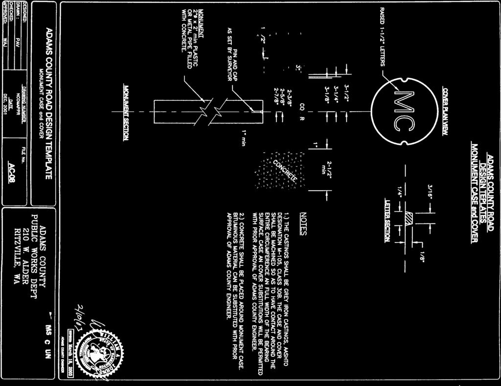
22 2. The cross slope of all elements such as, the pavement, ditches, swales, planting, strips, etc. 3. Dimensions of structural section material layers. 4. Retaining wall where required. 5. A separate full width roadway typical section for each road or portion of the road that differs significantly. Station limits shall be shown. 6. All other data necessary for a specific project 5.09 Not Used 5.10 DRAINAGE PLAN A drainage plan is required by Adams County. A private developer may submit the drainage plan integrally with the road plan and profile, if space permits. Otherwise, he/she shall submit it on separate plan and data sheets LAND SURVEY STANDARDS 6.01 REGULATIONS 1. Surveys shall conform to all applicable state and local regulations. 2. Prior to any construction within County right-of way, a surveyor shall conduct a thorough search for all survey monuments. Any found monuments shall be referenced in accordance with current applicable state laws. A copy of the references shall be filed in the office of the County Engineer MONUMENTATION 1. The responsible surveyor shall set permanent monuments with his/her registration number as follows: A. For placing new or replacement section corners, quarter corners, closing corners, witness corners, and meander points that have been disturbed or destroyed, the minimum acceptable monument is a ¾ inch inside diameter iron pipe or a #4 steel reinforcing rod 24 inches in length. The monument shall be marked in conformance with state law and regulations. Any of these corners in paved roads shall be covered by a Adams County standard cast iron monument case. Monument cases are shown on the Adams County Standard Plan sheet entitled Monument Case and Cover. B. For placing or replacement of disturbed road centerline angle points, curve points, and road intersection points, the minimum acceptable monument is a ½ inch inside diameter iron pipe or a #4 steel reinforcing rod, 18 inches in Adams County Standards 20
23 length. On principal arterials, monument cases and covers shall be set to protect the monuments. All monuments in other paved roads shall be set flush with the road surface. The monument shall be marked in conformance with state law and regulations. C. For placing new or replacement of all permanent monuments not covered above, the minimum acceptable monument is a ½ inch inside diameter iron pipe or #4 steel reinforcing rod, 18 inches in length. The monument shall be marked in conformance with state law and regulations. D. If it is impossible to set the above monument, the County Engineer may approve an alternative monument. 2. Each monument set according to A through D shall have at least three reference points. The reference points may consist of, in order of preference, cross on curbs, bearing trees, property corners or alternate approved by County Engineer HORIZONTAL CONTROL NET A horizontal control net established by the Adams County Engineer shall be the mapping base for all surveys lying within its boundaries. All surveys done within this net shall conform to the degree of accuracy required under applicable State laws with adequate supplemental information as required by the County Engineer to ensure accuracy TEMPORARY BENCHMARK The surveyor shall provide a temporary benchmark along the roadway every one thousand feet. These temporary bench marks shall be based on a datum plane approved by the County Engineer. The surveyor shall submit field notes or sealed statement insuring work according to third order accuracy. Please refer to Washington State Department of Transportation Standards Not Used 7.04 RETAINING WALLS AND OTHER STRUCTURES Analysis and design of retaining walls and other structures constructed within the County right-of-way and/or maintained by Adams County shall conform to the requirements of the current edition of the Standard Specifications for Highway Bridges, AASHTO. Plans and structural computations shall be submitted for approval of the County Engineer before construction begins. Mortarless concrete block retaining walls shall be designed and constructed in accordance with National Concrete Masonry Association Technical Report 127 (NCMA TR127) UTILITIES Adams County Standards 21
24 8.01 FRANCHISING POLICY Utilities to be located within the County road right-of-way shall be constructed according to current franchise and permit procedure and according to these standards in their use of the right of way, utilities shall be given consideration only after the requirements of the road are met. These requirements are to provide safe, efficient and convenient passage for motor vehicles, pedestrians, and other traffic STANDARD UTILITIES LOCATIONS Utilities within the right of way on new roads shall be located as shown on Standard Plan entitled Utility Locations. The locations shown on the standard plan shall be used on existing roadways where topography, utilities, or storm drains do not conflict. Where existing utilities or storm drains are in place, new utilities shall conform to these Standards as nearly as practical and yet be compatible with the existing installations. Exceptions may be approved when necessary to meet the special requirements of overhead utilities when right of way space is limited in planned unit developments, manufactured home parks, multifamily developments and commercial developments. 1. Not withstanding other provisions, underground systems shall be placed at least five feet away from road centerline and where they will not otherwise disturb existing survey monuments. 2. Underground utilities that can use a joint trench shall have the option of occupying any other utility company s standard location if that company is a participant in the joint trench installation. 3. Any utility company may use another utility company s standard location provided they obtain approval from that company. A copy of the approval shall be furnished to the County Engineer Not Used 8.04 SCHEDULING OF UTILITIES INSTALLATION, RELOCATION AND INSPECTION When possible, utilities, including service crossings, shall be installed or relocated before the start of road construction. If planned road cuts and fills are large or if the location of road elements cannot be clearly shown in advance, the utility company will coordinate the relocation of utilities with the contractor before construction. Otherwise, such utilities and connections shall be installed or relocated after the subgrade has been completed but before surfacing has been placed. As a matter of policy, Adams County discourages utility trenching or transverse cuts in County roads. Cutting or trenching roads that have been reconstructed within the previous five years will not be permitted unless it can be shown that alternatives are not Adams County Standards 22
25 feasible. Possible alternatives are boring, jacking, relocating outside the paved area, or installing the utility just before reconstruction or overlay of the road. In instances where trenching or cutting is permitted, pavement patching shall include: 1. cutting the existing pavement 2. removal of existing pavement 3. preparation and compaction of subgrade 4. placement and compaction of aggregate base material 5. application of tack coat and construction of the asphaltic concrete pavement patch This work shall conform to the applicable sections of the Washington State Department of Transportation Standard Specifications. On arterial roads, the utility company may be required to backfill the trench in paved roads with Portland cement concrete to within 0.10 feet to finish grade. This requirement may be applied on all paved roads during cool or inclement weather. Monumentation: The contractor, according to the Land Survey Standards section of these standards, shall protect existing survey monumentation PERMITS AND INSPECTION 9.01 APPLICATION Any party desiring to construct on county right-of-way, including connecting a road or driveway to a county road, shall first obtain a permit by filing a written application with the County Engineer. Such application shall be made on a Adams County form provided for that purpose, and shall include: 1. The name and address of the applicant 2. The name and address of the owner of the property abutting the road and where work is proposed. 3. The exact location of the proposed work, giving the road address or legal of the property involved. 4. A detailed plan or sketch accurately showing: A. The dimensions of the abutting property. B. The dimensions and locations of existing or proposed driveways. C. Utility poles. D. Hydrants. E. Road light Standards F. Trees within the limits of the frontage of said property. G. Other pertinent features. 5. The plan shall also show the location of buildings, loading platforms, and off-road parking facilities being served or to be served by such driveways. Adams County Standards 23
26 6. The County Engineer may require, at his discretion, the filing of any other information when he feels such information is necessary to properly enforce provisions of this section. 7. The County Engineer will not approve a plan nor issue a permit where it appears that the proposed work conflicts with the provision of this standard or any other ordinance or resolution of Adams County; nor shall issuance of a permit be construed as a waiver of the Zoning Ordinance or other ordinance requirements concerning the plan BASIS FOR CONTROL OF THE WORK Work shall be done to the satisfaction of the County Engineer and according to approved plans (Sections 5.00). This includes work done in the existing, proposed, or future public right of way. It applies to work by a private project sponsor, or by a county contractor. It is emphasized that no work may be started until such plans are approved. The County Engineer shall approve any revision to the plans before the proposed revision is constructed. The County Engineer shall have authority to enforce the Standards just as other referenced or pertinent specifications. He/she will appoint engineers, assistants, and inspectors as necessary to control and inspect the work and they will exercise such authority as the County Engineer may delegate. 1. PERMIT REQUIRED No person, firm or corporation shall commence work or permit any other person, firm, or corporation to commence work on the construction, alteration, repair, removal, cutting and/or paving of any road, alley or other public place in Adams County without first obtaining a written permit and approved plans from thecounty Engineer. The Sponsor shall be responsible for the County costs incurred for inspection. The costs shall be assessed as outlined on the latest fee schedule adopted by the Board of County Commissioner s. 2. TRAFFIC CONTROL DURING CONSTRUCTION Before commencing work on the project, the Sponsor shall prepare a signing plan according to the MUTCD. As work progresses, the Sponsor shall revise the signing plan to conform to changing conditions. The Sponsor shall provide flagmen to control traffic during the project. He/she shall also provide the flagmen s protective apparel, barricades, lights, standard signs, cones, and other devices for the protection of the public and maintenance of traffic through the project. Adams County Standards 24
27 9.03 Not Used 9.04 ROAD CONSTRUCTION INSPECTION The Sponsor s Engineer or a designated representative or Adams County may perform inspections on all road construction generated by a land use action Not Used 9.06 CONSTRUCTION INSPECTION NOTIFICATION AND RECORDS The Sponsor s Engineer shall be responsible to ensure that construction of roads and appurtenances is according to county accepted project plans, County General Provisions, the Standard Specifications, and applicable portions of the WSDOT Construction Manual. County forces may make random visits to public road construction sites, as deemed necessary. Random visits are to ensure a quality construction inspection process and do not express or imply approval or disapproval of the contractor s work. The County Engineer shall have access to all construction inspection records and reports. The Sponsor s Engineer shall submit all construction change orders that propose changes to the accepted plans or specifications to the County Engineer for his review and approval. The County Engineer will use a fast-track system for change order approvals when the progress of construction makes it infeasible to wait for formal approval. If, in the opinion of the County Engineer, the Sponsor s Engineer fails to satisfactorily perform the proper inspection, testing, and record-keeping duties, the County may take action as provided for in Section 1.10 Compliance Review. Prior to scheduling a final inspection with Adams County, the Sponsor s Engineer shall: 1. Submit all construction records to the County Engineer. This shall include but not be limited to, Daily Inspector s Reports, correspondence, manufacturer s certifications, material test reports, and Record Drawings as required in Section Ensure that all previously identified project deficiencies have been corrected. The Sponsor s Engineer shall schedule a final inspection meeting between the Sponsor s Engineer and the County Engineer prior to establishment of the road by Adams County. Deficiencies found shall be corrected by the Sponsor prior to road acceptance. At the time of establishment of the roads by the Board of County Commissioners, the County will assume responsibility for road maintenance and operation. The County will then release the Sponsor s Engineer from responsibility with regards to construction inspection Not Used 9.09 COUNTY FORCES AND COUNTY CONTRACT ROAD INSPECTION During construction, the Sponsor s Surveyor and/or Construction Engineer shall record any changes to the plans. Adams County Standards 25
28 All substantive differences shall be noted on the approved final road and drainage plans and shall be labeled Record Drawings. The following statement shall be lettered on the Record Drawings and stamped and signed by the Sponsor s Surveyor and/or Construction Engineer certifying the Record Drawings: I have reviewed the construction and to my knowledge find it to be in substantial conformance with the approved certified plans and Standard Specifications except as noted. When changes to the design are necessary, the Sponsor shall be responsible for obtaining approval of plan changes from the Sponsor s Design Engineer. The Sponsor shall forward a copy of the approved plan changes, and any related calculations, to the County Engineer BONDING PERFORMANCE BONDS A private sponsor of a project shall post a surety with the County Engineer to guarantee the construction in an amount equal to 110% of the County Engineer s estimate of all public roads, and private road improvements, including but not limited to the roadway, drainage improvements, utility work within County right-of-way, monumentation, and construction inspection costs. The bond shall conform to the following: 1. The surety shall be of a form approved by the Adams County Prosecuting Attorney s Office. 2. The term of the surety shall be for two years when it may be extended for an additional two years at the option of the County Engineer. The County Engineer will then calculate a new amount. 3. At the discretion of the County Engineer, a cash surety may be reduced with satisfactory progress on the project. The surety shall not be reduced below $20,000 or 20% of the original surety amount whichever is greater. 4. A performance bond will not be required if the improvements are constructed according to these standards prior to final plat approval. 5. The County will release a performance bond when all of the following conditions have been met: A. The sponsor s Construction Engineer submits the required certification that the project has been constructed in substantial conformance with the certified construction plans and specifications. B. The Sponsor submits Record Drawings and project records of all road and drainage improvements constructed by his project. C. The Sponsor has paid all costs incurred by the County in full. D. All monuments have been reset and referenced by a surveyor. E. (Public Roads only) A warranty bond is received by the County as specified in Section of these standards. F. (Public Roads only) The roads have been established by resolution of the Board of County Commissioners. Adams County Standards 26
29 If the Sponsor fails to construct the required improvements within the time limit allowed in Section D,the County Engineer shall use the surety to make the required improvements. In addition, he may request a moratorium on building permits until the required work is completed WARRANTY BONDS The sponsor of a private development shall post a warranty surety for improvements within County right-of way with the County Engineer before: 1. the establishment of any permitted road(s) by the Board of County Commissioners; and 2. the acceptance of drainage construction by the County Engineer; and 3. the release of the performance bond. The bond shall conform to the following: A. The surety be in effect for two years from the date of establishment of the road(s) by the Board of County Commissioners. B. The warranty surety shall be for an amount of 20% of the County Engineer s estimate of the construction costs or $10,000, which ever amount is greater. The County Engineer, at his/her discretion, may reduce the warranty bond amount for projects valued at less than $20,000. For approved, non-standard facilities, the County Engineer may require additional bonding up to 100% of the cost of the non-standard facility. C. The warranty surety shall guarantee against defects in road construction, utility work performed within the County right-of-way. and/or drainage facilities as determined by the County Engineer. D. The release of this surety for improvements within public right-of-way shall take place two years from the date of the establishment of the roads by the Board of County Commissioners. Thirty days prior to expiration of the warranty bond, the Sponsor shall retain a professional engineer to inspect the improvements. Any deficiencies noted must be repaired prior to the bond release. If the inspection is not conducted and the deficiencies are not repaired, the warranty bond shall be renewed by the Project Sponsor until the inspection is conducted and needed repair work is completed. Permit Bonds A surety, Commensurate with the extent of work to be done, shall be posted with the County Engineer before the issuance of a permit to work within public roads. Adams County Standards 27
30 STANDARD PLANS Adams County Standards 28
31
32

33

34

35

36


37
38
39

40

41
42
43
44

45
46

47
48

49
50
51
ROADWAY DESIGN AND CONSTRUCTION STANDARDS
 ROADWAY DESIGN AND CONSTRUCTION STANDARDS Adopted: 1990 Amended: 1994 2003 2011 2013 ROADWAY DESIGN AND CONSTRUCTION STANDARDS ORIGINALLY ADOPTED IN 1990 Resolution No. R-990-046 OFFICIALLY AMENDED IN
COUNTY OF YUBA DEPARTMENT OF PUBLIC WORKS IMPROVEMENT STANDARDS
 COUNTY OF YUBA DEPARTMENT OF PUBLIC WORKS IMPROVEMENT STANDARDS TABLE OF CONTENTS SECTION 1 PURPOSE AND DEFINITIONS 1.1 PURPOSE:... 1 1.2 DEFINITIONS:... 1 SECTION 2 GENERAL REQUIREMENTS 2.1 PLANS BY AN
CUYAHOGA COUNTY DEPARTMENT OF PUBLIC WORKS CUYAHOGA COUNTY ENGINEER TOWNSHIP SUBDIVISION STREET DESIGN STANDARDS AND IMPROVEMENT PLAN REQUIREMENTS
 CUYAHOGA COUNTY DEPARTMENT OF PUBLIC WORKS CUYAHOGA COUNTY ENGINEER TOWNSHIP SUBDIVISION STREET DESIGN STANDARDS AND IMPROVEMENT PLAN REQUIREMENTS November 25, 2013 Table of Contents Cuyahoga County Engineer's
Recommended Technical Standards for Existing Roads UNH Technology Transfer Center
 Recommended Technical Standards for Existing Roads UNH Technology Transfer Center Purposes and Acknowledgements These model standards provide New Hampshire cities and towns with a set of recommendations
CHAPTER 2. Restricted Residential ½ Street** Design Speed 25 MPH 25 MPH 25 MPH 25 MPH 40 MPH 50 MPH 55 MPH
 CHAPTER 2 201 ROADS 201.1 General This section is to assist the designer in determining what is needed for the design of roads in public rights-of-way. For these standards, the terms used are: Restricted
SECTION 12 STANDARDS FOR CONSTRUCTION PLANS AND SPECIFICATIONS
 SECTION 12 STANDARDS FOR CONSTRUCTION PLANS AND SPECIFICATIONS 12.1 The subdivider shall construct and install the improvements in accordance with the County's Standards for Construction Plans and Specifications
MONTEZUMA COUNTY COLORADO ROAD AND BRIDGE STANDARD SPECIFICATIONS
 MONTEZUMA COUNTY COLORADO ROAD AND BRIDGE STANDARD SPECIFICATIONS The following Standard Specifications for Road and Bridge Construction in Montezuma County, Colorado have been amended this 22 nd, day
SECTION 6. ROAD CONSTRUCTION STANDARDS
 SECTION 6. ROAD CONSTRUCTION STANDARDS Construction of new roads or reconstruction of existing roads proposed for dedication to the County shall conform to the standards set forth in this section. Roads
STREET STANDARDS FOR PRIVATE ROAD/STREET. Number of Travel Lanes Width of Travel Lanes Width of Right-of-Way. Subbase - Bank Run Gravel (6" minus)
") L. Road Construction All roads shall be a minimum of 200' in length and shall comply with all applicable provisions of this ordinance. No building permit shall be issued for a property until the road constituting
L. Road Construction All roads shall be a minimum of 200' in length and shall comply with all applicable provisions of this ordinance. No building permit shall be issued for a property until the road constituting
STREET IMPROVEMENTS (Refer to Title 18, chapter entitled "STREETS" of the Layton Municipal Code.)
") STREET IMPROVEMENTS (Refer to Title 18, chapter 18.24 entitled "STREETS" of the Layton Municipal Code.) I. Street widths STREET TYPE (ALL MEASUREMENTS IN FEET) ROW WIDTH LAYTON CITY STANDARD STREET SECTIONS
STREET IMPROVEMENTS (Refer to Title 18, chapter 18.24 entitled "STREETS" of the Layton Municipal Code.) I. Street widths STREET TYPE (ALL MEASUREMENTS IN FEET) ROW WIDTH LAYTON CITY STANDARD STREET SECTIONS
SUBDIVISION CHECKLIST. Subdivision Name. Prior To Review. Preliminary plan approved by Planning Commission / Council as required.
 SUBDIVISION CHECKLIST Subdivision Name Account Number Review Engineer Prior To Review Preliminary plan approved by Planning Commission / Council as required. Review fee paid. Statement of Responsibility
Streets CHAPTER 4 STREETS General
 CHAPTER 4 STREETS 4.01 General Street design must provide for the maximum loading conditions anticipated. The width and grade of the pavement must conform to specific standards set forth herein for safety
CITY OF TACOMA RIGHT-OF-WAY RESTORATION POLICY. Guidance on restoration of City Rights-of-Way
 CITY OF TACOMA RIGHT-OF-WAY RESTORATION POLICY Guidance on restoration of City Rights-of-Way Public Works Department Directors Office 747 Market Street Suite 408 Tacoma, WA 98402 253-591-5525 Right-of-Way
TOWN OF HOLLIS, NEW HAMPSHIRE
 TOWN OF HOLLIS, NEW HAMPSHIRE ROAD and DRIVEWAY SPECIFICATIONS APPENDIX (Adopted 10/7/08) APPENDIX A A. Road Design Standards 1. Pavement and drainage facilities, curbs and sidewalks, when required, shall
City of Duluth Development Regulations
 6.1 ACCESS ARTICLE 6 ACCESS AND RIGHT-OF-WAY REQUIREMENTS; AND STREET IMPROVEMENT AND CONSTRUCTION REQUIREMENTS 6.1.1 When land is subdivided into larger parcels than ordinary building lots, such parcels
Chapter 3: Permit Procedures and Requirements
 Chapter 1: General Provisions 1 1 Short Title 1 2 Jurisdiction 1 3 Amendments and Revisions 1 4 Enforcement Responsibility 1 5 Review Process 1 6 Prior Approval 1 7 Relationship to Other Standards 1 8
County Road Standards and Regulations
 County Road Standards and Regulations Pend Oreille County August 28, 2007-1 - (Page intentionally left blank.) - 2 - (Page intentionally left blank.) Table of Contents Chapter 1 General...9 1.010 Purpose...
CITY OF ASTORIA PUBLIC WORKS ENGINEERING DIVISION ENGINEERING DESIGN STANDARDS FOR IN-FILL DEVELOPMENT
 CITY OF ASTORIA PUBLIC WORKS ENGINEERING DIVISION ENGINEERING DESIGN STANDARDS FOR IN-FILL DEVELOPMENT Adopted by City Council: May 21, 2007 X:\General Eng\DESIGN STANDARDS\Engineering Design Standards
GENERAL NOTES ROADWAY CONSTRUCTION RD0001-1A ISSUED:2017 REVISED: --
 ROADWAY CONSTRUCTION NOTES 1. ALL RIGHT-OF-WAY OTHER THAN ROADWAY AREAS SHALL BE SODDED. ALL SLOPE STEEPER THAN 6:1 SHALL REQUIRE SODDING. THE CITY RESERVES THE RIGHT TO REQUIRE SODDING IN SPECIAL AREAS
CONSTRUCTION PLAN CHECKLIST
 CONSTRUCTION PLAN CHECKLIST The design engineer is responsible for ensuring that plans submitted for city review are in accordance with this checklist. It is requested that the executed checklist be submitted
Mason County Road Commission
 Mason County Road Commission Standards and Specifications For Street and Road Construction Board of County Road Commissioners Mason County Road Commission 1 Revised TABLE OF CONTENTS I. PURPOSE....1 II.
I. STREET CONSTRUCTION AND RECONSTRUCTION
 CITY OF OSHKOSH POLICY FOR SPECIAL ASSESSMENTS A. GENERAL I. STREET CONSTRUCTION AND RECONSTRUCTION 1. Assessments shall be levied according to the front foot dimensions of the abutting property to the
Section 7 Roadway GENERAL REQUIREMENTS I. TYPICAL SECTION...7-1
 Section 7 Roadway GENERAL REQUIREMENTS...7-1 I. TYPICAL SECTION...7-1 7.1 LANE WIDTHS...7-1 7.2 SHOULDER WIDTHS...7-1 7.3 CROSS SLOPE...7-2 7.4 CURB AND UNDERDRAINS...7-2 7.5 SIDEWALKS AND DRIVEWAYS...7-2
CONSTRUCTION SURVEY. Construction survey includes personnel, equipment, and supplies required for, but not limited to, the following:
 CONSTRUCTION SURVEY PART 1 - GENERAL 1.01 SECTION INCLUDES Construction survey includes personnel, equipment, and supplies required for, but not limited to, the following: A. Construction Survey: 1. Project
Matanuska- Susitna Borough Subdivision Construction Manual Update, Phase 1 4/6/2018 Summary of Changes
 Summary of Changes Throughout document Introduction Index Remove gendered pronouns Standardize language, vocabulary, acronyms Refer to latest edition of referenced publications Tie in subdivision code
Zoning Permits 11-1 ZONING PERMITS
 Zoning Permits 11-1 ZONING PERMITS (a) Building or structures shall be started, repaired, reconstructed, enlarged or altered only after a zoning permit has been obtained from the administrator and a building
SITE SPECIFIC GRADING PLAN FOR CONTIGUOUS SINGLE LOT SINGLE FAMILY RESIDENTIAL CONSTRUCTION WITH PREVIOUSLY APPROVED PRELIMINARY PLAT (FORM 2)
") WASHINGTON COUNTY DIVISION OF PLAN REVIEW AND PERMITTING 80 West Baltimore Street Hagerstown, Maryland 21740-6003 Telephone: (240) 313-2460 FAX: (240) 313-2461 Hearing Impaired call 7-1-1 for Maryland
WASHINGTON COUNTY DIVISION OF PLAN REVIEW AND PERMITTING 80 West Baltimore Street Hagerstown, Maryland 21740-6003 Telephone: (240) 313-2460 FAX: (240) 313-2461 Hearing Impaired call 7-1-1 for Maryland
PART II. - SPECIFICATIONS AND DESIGN STANDARDS TO CITY OF HEWITT, TEXAS SUBDIVISION ORDINANCE FOR PUBLIC WORKS CONSTRUCTION [TEXT]
![PART II. - SPECIFICATIONS AND DESIGN STANDARDS TO CITY OF HEWITT, TEXAS SUBDIVISION ORDINANCE FOR PUBLIC WORKS CONSTRUCTION [TEXT]](/thumbs/80/81891816.jpg "PART II. - SPECIFICATIONS AND DESIGN STANDARDS TO CITY OF HEWITT, TEXAS SUBDIVISION ORDINANCE FOR PUBLIC WORKS CONSTRUCTION [TEXT]") PART II. - SPECIFICATIONS AND DESIGN STANDARDS TO CITY OF HEWITT, TEXAS SUBDIVISION ORDINANCE FOR PUBLIC WORKS CONSTRUCTION [TEXT] A. - General. B. - Streets. C. - Stormwater drainage system. D. - Water
PART II. - SPECIFICATIONS AND DESIGN STANDARDS TO CITY OF HEWITT, TEXAS SUBDIVISION ORDINANCE FOR PUBLIC WORKS CONSTRUCTION [TEXT] A. - General. B. - Streets. C. - Stormwater drainage system. D. - Water
ZONING ORDINANCE FOR THE ZONED UNINCORPORATED AREAS ARTICLE 1500 OF PUTNAM COUNTY, WEST VIRGINIA Page 149 ARTICLE 1500 DRAINAGE AND STORM SEWERS
 OF PUTNAM COUNTY, WEST VIRGINIA Page 149 ARTICLE 1500 DRAINAGE AND STORM SEWERS 1500.01 GENERAL REQUIREMENTS 1500.02 NATURE OF STORM WATER FACILITIES 1500.03 DRAINAGE EASEMENTS 1500.04 STORM WATER MANAGEMENT
SOUTHSIDE TOWNSHIP ROADWAY STANDARDS POLICY Adopted September 7, 2004
 SOUTHSIDE TOWNSHIP ROADWAY STANDARDS POLICY Adopted September 7, 2004 General: Sections of the Minnesota Department of Transportation (Mn/DOT), Standard Specification for Construction, 2000 or Current
GRAYSON COUNTY POLICY, PROCEDURES AND SPECIFICATIONS OF GRAYSON COUNTY, TEXAS FOR THE INSTALLATION OF DRIVEWAY
 GRAYSON COUNTY POLICY, PROCEDURES AND SPECIFICATIONS OF GRAYSON COUNTY, TEXAS FOR THE INSTALLATION OF DRIVEWAY CULVERTS, ROAD BORES, USE OF HEAVY EQUIPMENT AND UTILITY LINES WITHIN GRAYSON COUNTY ROAD
Construction Requirements for Installation of Utilities in the Public Right-of-way of McPherson County, Kansas October 2011
 Construction Requirements for Installation of Utilities in the Public Right-of-way of McPherson County, Kansas October 2011 General Provisions and Specifications - These provisions and specifications shall
Larimer County Land Use Code Section 5.8: Rural Land Use Process
 Larimer County Land Use Code Section 5.8: Rural Land Use Process 5.8.6 PRINCIPLES D. Development Standards 3. Engineering Standards and Guidelines for Roads and Drainage The following Standards and Guidelines
CHAPTER 3 SCOPE SUMMARY
 CHAPTER 3 SCOPE SUMMARY GENERAL The SDDOT is an active member of AASHTO to share common national design standards for the state highway system. The AASHTO Task Force on Geometric Design has completed the
SECTION 13 - EXISTING FACILITIES TABLE OF CONTENTS
 SECTION 13 - EXISTING FACILITIES TABLE OF CONTENTS Section Page 13-1 GENERAL... 13.1 13-1.01 Preservation of Property... 13.1 13-1.02 Overloading, Pavement Protection & Repair... 13.1 13-2 REMOVING EXISTING
COUNTY OF SUTTER ENCROACHMENT PERMIT
 COUNTY OF SUTTER ENCROACHMENT PERMIT PERMIT No. Development Services Dept. Engineering Division 1130 Civic Center Blvd Yuba City, CA 95993 (530) 822-7400 Hours: 8 AM - 5 PM Upon completion, submit application
CHAPTER 70 PUBLIC WORKS DEPARTMENT DEVELOPMENT STANDARDS ARTICLE 70 BASIC PROVISIONS
 CHAPTER 70 PUBLIC WORKS DEPARTMENT DEVELOPMENT STANDARDS ARTICLE 70 BASIC PROVISIONS 70.010 - PURPOSE The purpose of this chapter is to establish standards for the design and development of sites in order
UNIFORM DESIGN AND CONSTRUCTION STANDARDS FOR EXTENDING WATER DISTRIBUTION SYSTEMS SECTION 2 DESIGN STANDARDS
 UNIFORM DESIGN AND CONSTRUCTION STANDARDS FOR EXTENDING WATER DISTRIBUTION SYSTEMS SECTION 2 DESIGN STANDARDS DESIGN STANDARDS SECTION 2 INDEX ITEM DESCRIPTION 2.00 GENERAL STATEMENT 2.01 WATER DISTRIBUTION
SECTION 14 - RESTORATION OF SURFACES TABLE OF CONTENTS
 SECTION 14 - RESTORATION OF SURFACES TABLE OF CONTENTS Section Page SECTION 14 RESTORATION OF SURFACES... 14.1 14-1 GENERAL... 14.1 14-2 PRIVATE ROADS... 14.1 14-3 STREETS AND PARKING LOTS... 14.1 14-3.01
Walker County Manufactured Home Rental Community Regulations Infrastructure Development Plan
 A. In accordance with Local Government Code Section 232.007, an Infrastructure Development Plan (IDP) is required for all manufactured home rental communities, as defined in Section A 1.0 E of these regulations,
PUBLIC AND PRIVATE IMPROVEMENTS CODE OF THE TOWNSHIP OF UPPER ST. CLAIR
 99.0 PUBLIC AND PRIVATE IMPROVEMENTS CODE 99.0 PUBLIC AND PRIVATE IMPROVEMENTS CODE OF THE TOWNSHIP OF UPPER ST. CLAIR TABLE OF CONTENTS 99.1. ADMINISTRATION AND GENERAL REGULATIONS...2 99.1.1. Title...2
APPLICANT any person who makes application for a permit. BOROUGH Borough of Elizabethtown, Lancaster County, Pennsylvania.
 CHAPTER 21 PART 2 TUNNELING AND EXCAVATIONS 201. Definitions. The following words and phrases, when used in this Part, shall have the meanings ascribed to them in this 201, except in those instances where
ARTICLE XII RECREATIONAL VEHICLE PARK REGULATIONS
 ARTICLE XII RECREATIONAL VEHICLE PARK REGULATIONS ARTICLE XII RECREATIONAL VEHICLE PARK REGULATIONS Section 1201 Applicability For the purpose of this Article, recreation vehicles and recreational vehicle
SECTION CONSTRUCTION SERVICES
 SECTION 01100 CONSTRUCTION SERVICES PART 1 GENERAL 1.01 - Section Includes A. Mobilization. B. Construction Surveys. C. Record Documents. 1.02 Description Of Work A. Mobilization: includes the preparatory
PLANNING AND ZONING COMMISSION APPLICATION FOR IMPROVEMENT PLAT APPROVAL
 PLANNING AND ZONING COMMISSION APPLICATION FOR IMPROVEMENT PLAT APPROVAL Date Submitted: Project Number: CITY OF ALEXANDRIA 8236 WEST MAIN STREET ALEXANDRIA, KY 41001 (859) 635-4125 FAX (859) 635-4127
SECTION 3 DRAINAGE. 3-1 General. 3-2 Drainage Ordinances and Legal Requirements
 SECTION 3 DRAINAGE 3-1 General All Drainage plans for proposed development shall be prepared by a Professional Engineer registered in Virginia, except as noted below. Further, their seal and signature
CITY OF LA QUINTA GENERAL NOTES GENERAL NOTES
 CITY OF LA QUINTA GENERAL NOTES GENERAL NOTES 1. ALL WORK SHALL BE DONE IN ACCORDANCE WITH THE LATEST EDITION OF THE STANDARD PLANS OF THE CITY OF LA QUINTA, THE LATEST EDITION OF THE STANDARD SPECIFICATIONS
PRIVATE ROAD AND DRIVEWAY STANDARDS Development Standard #1 (Rev 7/18)
") PRIVATE ROAD AND DRIVEWAY STANDARDS Development Standard #1 (Rev 7/18) I. GENERAL REQUIREMENTS FOR DRIVEWAYS AND PRIVATE ROADS A. Fire District access roads shall be provided and maintained in accordance
PRIVATE ROAD AND DRIVEWAY STANDARDS Development Standard #1 (Rev 7/18) I. GENERAL REQUIREMENTS FOR DRIVEWAYS AND PRIVATE ROADS A. Fire District access roads shall be provided and maintained in accordance
SECTION GENERAL EXCAVATION
 02210-1 of 11 SECTION 02210 GENERAL EXCAVATION 02210.01 GENERAL A. Description 1. General excavation shall include but not necessarily be limited to, excavation and grading for general site work, roadways,
SECTION TRAFFIC REGULATIONS
 PART 1 GENERAL 1.1 DESCRIPTION A. Traffic Control permits, notifications, mobilization, temporary signs, barriers, lights, flagging personnel, striping, markings, and demobilization and removal. 1.2 RELATED
T a b l e o f C o n t e n t s
 C i t y o f G l a d s t o n e P u b l i c W o r k s D e s i g n S t a n d a r d s T a b l e o f C o n t e n t s SECTION THREE SANITARY SEWER REQUIREMENTS... 1 3.0000 SANITARY SEWERS... 1 3.0010 General
APPENDIX A DESIGN SPECIFICATIONS FOR NEW ROAD CONSTRUCTION
 APPENDIX A DESIGN SPECIFICATIONS FOR NEW ROAD CONSTRUCTION 1. GENERAL SPECIFICATIONS 1.1 Specifications: Plans shall be prepared by a professionally registered engineer duly authorized to conduct business
GRADING & DRAINAGE PERMIT SOIL EROSION AND SEDIMENTATION CONTROL PERMIT PROGRAM OVERVIEW
 GRADING & DRAINAGE PERMIT SOIL EROSION AND SEDIMENTATION CONTROL PERMIT PROGRAM OVERVIEW Chapter 8 Building and Building Regulations, Article XIII Grading and Drainage and Article XV Soil Erosion and Sedimentation
RESTORATION SPECIFICATION
 In proposed subdivision roadways where other utilities are present, the design plans should illustrate all possible utility line conflicts (crossings). During design and construction, care shall be utilized
Town of Sun Prairie Driveway Permits Standard Operating Procedure
 Town of Sun Prairie Driveway Permits Standard Operating Procedure A. Purpose To provide a standard procedure for issuing driveway access permits to town roads. To provide inspection of the construction
ORDER ADOPTING MINIMUM INFRASTRUCTURE STANDARDS FOR MANUFACTURED HOME RENTAL COMMUNITIES IN GRAYSON COUNTY, TEXAS PREAMBLE
 ORDER ADOPTING MINIMUM INFRASTRUCTURE STANDARDS FOR MANUFACTURED HOME RENTAL COMMUNITIES IN GRAYSON COUNTY, TEXAS PREAMBLE WHEREAS, the Legislature has enacted legislation, codified as Local Government
Appendix 3. POLICY & PROCEDURE No
 DEPARTMENT OF PUBLIC WORKS DIVISION: ENGINEERING SERVICES SECTION: ADMINISTRATIVE PAGE NO: 1 OF 10 REVISION NO: 3 DATE: 1995 05 01 ESTABLISHED: 1986 03 03 Appendix 3 POLICY & PROCEDURE No. 2.3.1-020 TITLE:
Ordinance No Lot Surface Drainage
 Ordinance No. 35-2008 - Lot Surface Drainage The Township has adopted a new Lot Surface Drainage Ordinance which amends Chapter 170, Article IX, Subdivision and Site Plan Review by adding a new Section
SECTION 14 - RESTORATION OF SURFACES TABLE OF CONTENTS
 SECTION 14 - RESTORATION OF SURFACES TABLE OF CONTENTS Section Page 14-1 GENERAL... 14.1 14-2 PRIVATE ROADS... 14.1 14-3 STREETS AND PARKING LOTS... 14.1 14-3.01 Aggregate Base... 14.1 14-3.02 Asphalt
STANDARD GRADING AND SOIL EROSION & SEDIMENT CONTROL PLAN FOR SINGLE LOT SINGLE FAMILY RESIDENTIAL CONSTRUCTION AND MINOR EARTH DISTURBANCES
 DIVISION OF ENGINEERING & CONSTRUCTION MANAGEMENT PLAN REVIEW DEPARTMENT WASHINGTON COUNTY SOIL CONSERVATION DISTRICT 1260 Maryland Avenue, Suite 101 Hagerstown, MD 21740 Telephone: (301) 797-6821, Ext.
Sidewalk Regulations. Table of Contents
 Sidewalk Regulations Table of Contents Section 1. Purpose and Intent... 2 Section 2. Pedestrian Sidewalk, Driveway Apron and Curb and Guttering Requirements... 2 Section 3. Sidewalk Provision Criteria...
CITY OF SOUTH LAKE TAHOE APPLICATION FOR ENCROACHMENT, EXCAVATION and GRADING WITHIN THE CITY RIGHT OF WAY
 CITY OF SOUTH LAKE TAHOE APPLICATION FOR ENCROACHMENT, EXCAVATION and GRADING WITHIN THE CITY RIGHT OF WAY The Right-of-Way Encroachment, Excavation & Grading Permit issued by the Public Works Department
York County Engineering Department Roadway Inspection Requirements
 York County Engineering Department Roadway Inspection Requirements The following is a list, in order, of the roadway inspections that are required to be passed by York County before a subdivision can receive
CODE CONSOLIDATION PHASE II SUMMARY OF CHANGES Effective February 1, 2011, Ordinance s
 CODE CONSOLIDATION PHASE II SUMMARY OF CHANGES Effective February 1, 2011, Ordinance 2010-70s Revisions to Title 2 Administration 2.45 Land Use Advisory Commissions. Twelve individual LUAC chapters were
TRANSPORTATION & PUBLIC WORKS DEPARTMENT TECHNICAL STANDARDS
 Athens-Clarke County Unified Government TRANSPORTATION & PUBLIC WORKS DEPARTMENT TECHNICAL STANDARDS JULY, 2009 PREFACE The technical standards presented herein reflect the current policies and practices
District No.: Applicant: Type of Work:
 Fee: Permit No.: District No.: Applicant: Type of Work: FOR DEPARTMENT USE ONLY APPLICATION AND ANNUAL PERMIT FOR TELECOMMUNICATION OCCUPANCY OF NEVADA DEPARTMENT OF TRANSPORTATION RIGHT-OF-WAY (Under
COUNTY OF ALBEMARLE. Community Development Department 401 McIntire Road, Room 227 Charlottesville, Virginia (434)
") COUNTY OF ALBEMARLE ZONING INFORMATION PACKET (For building permits for a structure on a property with a site plan) Community Development Department 401 McIntire Road, Room 227 Charlottesville, Virginia
COUNTY OF ALBEMARLE ZONING INFORMATION PACKET (For building permits for a structure on a property with a site plan) Community Development Department 401 McIntire Road, Room 227 Charlottesville, Virginia
TOWN OF MANCHESTER PLANNING AND ZONING COMMISSION Subdivision Application Minimum Submission Requirements
 TOWN OF MANCHESTER PLANNING AND ZONING COMMISSION Subdivision Application Minimum Submission Requirements This checklist is to be completed and submitted with all Subdivision Applications. The Town reserves
EXCAVATION WORK IN PUBLIC RIGHT-OF-WAY GENERAL NOTES
 CITY OF SANTA MONICA Department of Public Works Civil Engineering Division 1685 Main, Room 116 Santa Monica, CA 90401 Tel: (310) 458-2240 or (310) 458-8737 EXCAVATION WORK IN PUBLIC RIGHT-OF-WAY GENERAL
TABLE OF CONTENTS. Manual Section. Introduction 1. Using This Manual 2-3. Administrative Actions 4-6. Road and Bridge Project Types 7
 ii TABLE OF CONTENTS Manual Section Pages Introduction 1 Using This Manual 2-3 Administrative Actions 4-6 Road and Bridge Project Types 7 Road and Bridge Funding Programs 8-9 Project Planning and Eligible
CHAPTER 5 WATER SYSTEM DESIGN STANDARDS
 CHAPTER 5 WATER SYSTEM DESIGN STANDARDS TABLE OF CONTENTS CHAPTER 5 WATER SYSTEM DESIGN STANDARDS 5.00 Objective Page 1 5.01 Additional Referenced Standards Page 1 5.02 Special Design Problems Page 2 5.03
York County Engineering Department Roadway Inspection Requirements
 York County Engineering Department Roadway Inspection Requirements The following is a list, in order, of the roadway inspections that are required to be passed by York County before a subdivision can receive
PERMITTED USES: Within the MX Mixed Use District the following uses are permitted:
 6.24 - MX - MIXED USE DISTRICT 6.24.1 INTENT: The purpose of the MX Mixed Use District is to accommodate the development of a wide-range of residential and compatible non-residential uses (including major
GENERAL NOTES REQUIRED NOTES ON ALL PLANS
 GENERAL NOTES REQUIRED NOTES ON ALL PLANS ALL MATERIALS, WORKMANSHIP AND CONSTRUCTION SHALL CONFORM TO THE CURRENT CITY OF SANTA ROSA DESIGN AND CONSTRICTIOIN STANDARDS AND CONSTRUCTION SPECIFICATIONS
SECTION MAINTENANCE OF EXISTING CONDITIONS
 SECTION 02 01 00 MAINTENANCE OF EXISTING CONDITIONS PART 1 GENERAL 1.1 GENERAL A. The CONTRACTOR shall protect all existing utilities and improvements not designated for removal and shall restore damaged
CHAPTER 7 ROADWAY STANDARDS AND TECHNICAL CRITERIA
 Table of Contents CHAPTER 7 ROADWAY STANDARDS AND TECHNICAL CRITERIA Table of Contents 7-01 ROADWAY DESIGN AND TECHNICAL CRITERIA...1 7-01-01 General...1 7-01-02 Required Design Submittals...2 7-01-03
A.1 WATER SYSTEM PLAN SUBMITTAL PROCEDURES AND GENERAL REQUIREMENTS
 PC Plan Submittal and Review A.1 WATER SYSTEM PLAN SUBMITTAL PROCEDURES AND GENERAL REQUIREMENTS All plans for water main extensions, improvements and modifications shall be submitted to the District manager.
APPLICATION FOR PUBLIC INFRASTRUCTURE PERMIT
 APPLICATION FOR PUBLIC INFRASTRUCTURE PERMIT Engineering Division 550 Landa Street New Braunfels, Texas 78130 (830) 221-4020 1. Subdivision Plat Name: Location Description/ Nearest Intersection: Acreage:
SPECIFICATIONS FOR STREET CONSTRUCTION WITHIN THE TOWN OF PLAINVILLE
 SPECIFICATIONS FOR STREET CONSTRUCTION WITHIN THE TOWN OF PLAINVILLE BE IT ORDAINED by the Town Council of the Town of Plainville: SECTION 1. SUBDIVISIONS. All subdivisions hereinafter developed within
CONSTRUCTION STAKING GUIDELINES
 CITY OF LOS ANGELES DEPARTMENT OF PUBLIC WORKS BUREAU OF ENGINEERING SURVEY DIVISION CONSTRUCTION STAKING GUIDELINES Gary Lee Moore, P.E., City Engineer Tony Pratt, Chief Surveyor TABLE OF CONTENTS Dec.
ARTICLE 700 LARGE SCALE DEVELOPMENTS
 ARTICLE 700 LARGE SCALE DEVELOPMENTS SEC. 700.1 APPLICABILITY A development plan shall be submitted to the Bentonville Planning Commission for all developments or building construction regardless of zone
CHAPTER 500 STREET PAVEMENTS, CURB, GUTTER AND SIDEWALK CONSTRUCTION SPECIFICATIONS
 CHAPTER 500 STREET PAVEMENTS, CURB, GUTTER AND SIDEWALK CONSTRUCTION SPECIFICATIONS The following list of Standard Documents defines the methods, materials, and testing to be utilized when designing and
TITLE TEN - STREETS AND SIDEWALKS
 TITLE TEN - STREETS AND SIDEWALKS Table of Contents CHAPTER 1 - IMPROVEMENTS, EXCAVATIONS, ALTERATIONS... 2 CHAPTER 2 - OBSTRUCTIONS... 5 CHAPTER 3 - SIDEWALK INSTALLATION... 6 CHAPTER 4 - COMMERCIAL LANDSCAPING...
LAGRANGE TOWNSHIP 353 South center street p.o. box 565 lagrange ohio 44050
 LAGRANGE TOWNSHIP 353 South center street p.o. box 565 lagrange ohio 44050 Resolution 2004-5 Resolution of the Board of Trustees of LaGrange Township, Lorain County, Ohio, adopting general rules and regulations
B-PERMIT PLAN CHECK MANUAL
 B-PERMIT PLAN CHECK MANUAL 11. PLAN SHEETS AND NOTES Preformatted B-Permit plans sheets can be downloaded from the internet on the Bureau of Engineering s website. The Plan sheets can be found under the
DIVISION 6. ACCESSORY USES OR STRUCTURES
 DIVISION 6. ACCESSORY USES OR STRUCTURES Sec. 58-591. Generally. (a) Principal use or structure required to be present. An accessory use or structure in any zoning district shall not be established prior
DIVISION OF BUILDING ZONING AND INSPECTION PLANNING COMMISSION REGULATIONS
 DIVISION OF BUILDING ZONING AND INSPECTION PLANNING COMMISSION REGULATIONS Regulations for Applicants Requesting Appearance before the City of Wickliffe Planning Commission for Institutional, Multi- Family,
SUBDIVISION SECTION STREET DESIGN MANUAL
 CITY OF ANAHEIM SUBDIVISION SECTION STREET DESIGN MANUAL A. INTRODUCTION : POLICY STATEMENT B. STREET CLASSIFICATION C. STREET STANDARDS REQUIREMENTS Requirements Approval of Street Improvement Plans Widening
PennDOT Pub. 170 Highway Occupancy Permit (HOP) Manual Page 56
 Manual Page 56") PennDOT Pub. 170 Highway Occupancy Permit (HOP) Manual Page 56 Additional Fees Additional fees may be charged by PennDOT consistent with Sections 411 and 420 of the State Highway Law and Regulations 441.4(d)
PennDOT Pub. 170 Highway Occupancy Permit (HOP) Manual Page 56 Additional Fees Additional fees may be charged by PennDOT consistent with Sections 411 and 420 of the State Highway Law and Regulations 441.4(d)
Shawnee Design and Construction Manual. Volume II Design Criteria Edition
 Volume II Design Criteria 2014 Edition DIVISION 2200 STREETS SECTION 2205 STREET DESIGN 1.01 GENERAL The purpose of these criteria is to provide uniform procedures for designing and checking the design
SECTION FIVE TABLE OF CONTENTS
 SECTION FIVE TABLE OF CONTENTS 5A. GENERAL... 1 5B PUBLIC WORKS CONSIDERATIONS... 1 5B.010 Standard Specifications... 1 5B.020 Plan Checklist... 2 5B.030 Plan and Profile Submittal... 2 5B.040 Workmanship
Index. Composition and Order of Plan Set. Utility Plan... 5
 City of Des Plaines Public Works and Engineering Department Revised-October 5, 2012 Index Composition and Order of Plan Set Title Page Number Cover Sheet... 1 Requirements for Site Development... 2 Grading
N.J.A.C. 19: This file includes all Regulations adopted and published through the New Jersey Register, Vol. 50 No. 1, January 2, 2018
 N.J.A.C. 19:66-8.1 19:66-8.1 Purpose (a) This subchapter serves the following purposes: 1. To provide for the comprehensive and orderly development of the district in accordance with the Tourism District
KITSAP COUNTY ROAD STANDARDS 2007 TABLE OF CONTENTS
 KITSAP COUNTY ROAD STANDARDS 2007 TABLE OF CONTENTS Chapter 1 Introduction 1.1 Authority and Intent...1 1.2 Application...2 1.3 Associated Regulations and Specifications...2 1.4 Design Approval and Technical
SECTION UNIT PRICES. A. This Section specifies administrative and procedural requirements for the unit prices.
 SECTION 01220 UNIT PRICES PART 1 GENERAL 1.01 SUMMARY A. This Section specifies administrative and procedural requirements for the unit prices. B. The omission of any unit price description from this Section
CITY OF MADRAS RIGHT-OF-WAY CONSTRUCTION & USE PERMIT 125 SW E Street, Madras, OR Telephone (541) Fax (541)
 Fax (541)") CITY OF MADRAS RIGHT-OF-WAY CONSTRUCTION & USE PERMIT 125 SW E Street, Madras, OR 97741 Telephone (541)475-2344 Fax (541)475-1038 Permit type (may include multiple types, please provide detail in the the
CITY OF MADRAS RIGHT-OF-WAY CONSTRUCTION & USE PERMIT 125 SW E Street, Madras, OR 97741 Telephone (541)475-2344 Fax (541)475-1038 Permit type (may include multiple types, please provide detail in the the
SECTION PROTECTION AND RESTORATION OF EXISTING FACILITIES
 PART 1 - GENERAL 1.1 GENERAL A. The CONTRACTOR shall protect all existing utilities and improvements not designated for removal and shall restore damaged or temporarily relocated utilities and improvements
SECTION TRENCHING & BACKFILLING
 SECTION 02225 - TRENCHING & BACKFILLING 1.0 GENERAL 1.1 Work included in this Section includes trenching and backfilling for underground pipelines and related structures only. 1.2 Reference Specifications