Form 1: Application for resource consent
|
|
|
- Baldwin Norman
- 6 years ago
- Views:
Transcription
1 Form 1: Application for resource consent All sections must be completed in full and accompanied by the initial fixed application fee (see section 11) and the relevant activity form (see section 7). Failure to do so may result in your application not being accepted and/or returned. Please note that all information provided in your application is available to the public. You can lodge your application in any of the following ways: By post to PO Box 11646, Wellington or PO Box 41, Masterton In person at our Wellington office (142 Wakefield Street) or Masterton office (34 Chapel Street) By to (a signed PDF copy is required) Office use only: FILE REF: Doc. No. Referred to Int 1. Applicant s details Applicant(s) name(s) and address ie, whose name will be on the consent. Note if a private or family trust is the applicant, all the trustees are required to provide contact details and sign the application form (see 4. below) T: Business: T: Private: Fax: T: Mobile: address: The applicant is the: Owner Occupier Lessee Prospective Purchaser The Crown Network Utility Operator Other Please specify: 2. Agent s details Agent s name and address Please note that all correspondence will be sent to the Agent as the first point of contact during the application process, unless instructed otherwise T: Business T: Private Fax: T: Mobile: address: 3. Property owner s name (if different from above) Property owner s name and address T: Business T: Private Fax: T: Mobile: address: If your proposed activity will take place on land not owned by the applicant, the written approval of the property owner must be provided on a completed and signed form 1B. 07/13
2 4. Partnership/unincorporated entity details For partnerships or unincorporated entities (such as private trusts or unincorporated bodies or societies) you must provide details of all authorised partners, trustees or members. Any consent granted will then include these names, and all individuals will be legally responsible for the consent and any associated costs. Should these persons change, then you must notify us. Full name of person: Status (eg, partner, trustee): Address: address: Phone: Full name of person: Status (eg, partner, trustee): Address: address: Phone: Full name of person: Status (eg, partner, trustee): Address: address: Phone: Include details of any further partners/trustees/members on a separate page if necessary 5. Location of proposed activity Describe the location of activity and/or property address Map reference: NZTM: Valuation reference [from rates]: Include the name of any relevant stream, river or other waterbody to which the application may relate, proximity to any well known landmark, etc. (Note: a location map is required in your activity form.) Legal description [from rates notice] [eg, Lot 9 DP58809 Block XI] 6. Description of proposed activity 2
3 7. Consents from the Greater Wellington Regional Council activity forms you need to fill in Consent(s) being applied for. You will need to fill in an activity form for each of the following activities: Make sure you attach the forms for your activity Water: Land Use: Dam/Divert (Form 2a) General river/stream works (Form 6a) Take and use surface water (Form 2b) Bore/well construction (Form 6b) Take and use groundwater (Form 2c) Bridge/culvert/pipe (Form 6c) Discharge to Land: Erosion protection structures (Form 6d) General discharges (Form 3a) Land clearing/tracking/logging soil disturbance (Form 6e) Agricultural discharge (Form 3b) Coastal: On-site wastewater (Form 3c) General coastal (Form 7a) Discharge to Water: Boatshed (Form 7b) General discharges (Form 4a) Swing mooring (Form 7c) Discharge to Air: Air discharge (Form 5a) 8. Consents from local authorities Territorial authority in which land is situated: Wellington City Council Hutt City Council Upper Hutt City Council Porirua City Council Kapiti Coast District Council Masterton District Council South Wairarapa District Council Carterton District Council Do you require any other resource consents from your local council? Yes No If yes, please list: Have these consents been applied for? Yes No 9. Other documentation Please list any documents in addition to your application forms that form part of your application. Note: if multiple other documents exist, please attach a separate sheet of paper. No other documents Reports Plans Other documents Title Title Title Title 3
4 10. Consultation and written approval of affected persons Consultation with all persons potentially affected by your activity prior to lodging your application may result in considerable time and cost savings. Non-notified applications Non-notified consents are for activities which have minor effects on the environment. For your activity to be considered on a non-notified basis you must consult and obtain written approval from all persons potentially affected by your activity (eg, neighbours, iwi, Fish and Game Council, Department of Conservation). If you are unsure who may be an affected party, please call us. Non-notified consents are significantly cheaper and quicker to process. Limited notified and fully notified applications Notified consents (either limited notified or fully notified consents) are for activities which do not meet requirements in the RMA for processing on a non-notified basis. Please provide any consultation details and written approvals obtained in the space provided below. Consultation details Have you consulted with iwi? Yes No If so, who did you consult? Who else have you consulted? What was their response? How have you addressed any concerns they may have had? Written approval of affected parties If you have obtained the signature of affected persons please give their details below. Please note that for us to accept the approvals they must each complete and sign form 1B. Name Address Contact details (phone, etc) 4
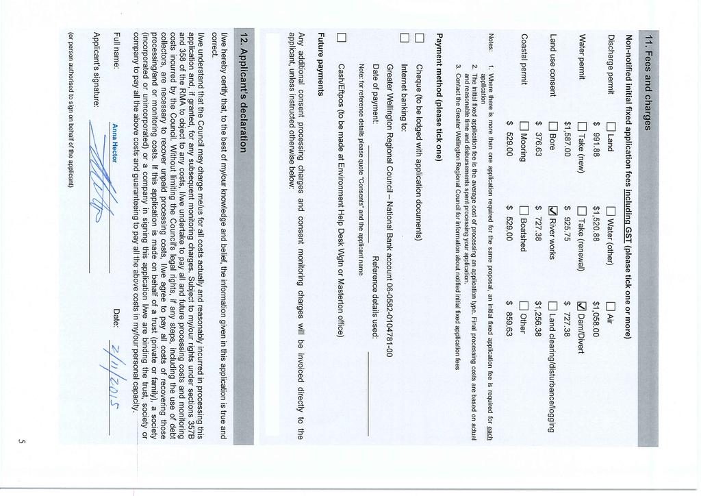
5
6 6a Land use consent application general works in the bed of a watercourse or lake Please answer all questions fully. Officers from the Environmental Regulation Department are available to assist with filling out this form or to clarify information to include with your application. This form is required to be filled out in conjunction with Form 1 Resource Consent Application This application form should be used for any general works in the bed of a watercourse or lake. Please note if you are constructing a bridge, culvert or pipe please fill in application form 6c, or if you are constructing erosion protection structures please fill in application form 6d. Part A: General information on nature and scale of your activity 1. Is this application for a renewal of an existing resource consent? Yes No If Yes, what is the consent number? WAR/WGN 2. What do you propose to do and why? 3. Are you: (1) Erecting, reconstructing, placing, altering, extending, removing or demolishing any structure? Yes No (2) Excavating, drilling, tunnelling or disturbing the bed (including gravel extraction see below)? Yes No (3) Depositing any substance? Yes No (4) Reclaiming or draining the bed? Yes No (5) Introducing or planting any plants? Yes No (6) Disturbing, removing, damaging or destroying any plants, or the habitats or any plants or animals? Yes No (7) Crossing a watercourse? Yes No For gravel extraction, please state the volume of gravel to be extracted: One-off extraction m 3 (within 1 year unless otherwise specified): Ongoing extraction m 3 per year until. 05/13
7 Part A: general (continued) 4. Name the watercourse where the works will occur? (If the watercourse is an unnamed tributary then what is the name of the stream/river it flows into?) 5. Describe the current nature of the watercourse at the proposed site for the works? Nature of channel, ie, meandering or straight: Water colour/clarity: Average flow (m 3 /sec): Bed material (eg, rocky, silty): Bank material: Vegetation: Fish and invertebrate life: Other: 6. Construction/works methodology Please provide a step by step construction/works methodology, including any temporary diversion of water required to undertake the works and any site rehabilitation proposed once the works are completed. 2
8 Part A: general (continued) 7. Locality map Show the location and a detailed sketch/plan of your proposed activity. Please show the proposed activity in relation to roads, property boundaries, neighbouring properties, watercourses, wetlands and other wildlife habitats, existing surrounding structures, historic or wāhi tapu sites, key landmarks, and any other relevant features of the surrounding environment. Alternatively you may wish to attach a plan/aerial photograph showing the above information. Note: Remember to show where north is. 3
9 Part A: general (continued) 8. Site photographs Please attach labelled photographs of the site in its present form which include: any existing structures at the site any eroded areas of bank in the vicinity of the proposed works the view of the watercourse downstream of the site the view of the watercourse upstream of the site the view of the watercourse and its banks where it will be affected by the works Please describe the location from which the photographs were taken and indicate whether the proposed site is typical of the watercourse, eg, 10m downstream, from the proposed site, vegetation type typical of the watercourse. Please also provide a scale, eg, have a person in the photograph. 9. Who will be undertaking the work? 10. What are the proposed hours of operation/construction? 11. What is the proposed commencement date of the work? 12. What is the duration of the works? 13. What is the duration of the works to be undertaken within the watercourse? 14. Have any alternatives been considered when planning the proposal? Yes No Please explain: 15. As part of your proposal will you be undertaking any of the following activities? Diversion of water Bulk earthworks adjacent to any watercourse Note: If you have ticked any of the above boxes you may be required to fill out an additional form to be submitted as part of your application. Please contact the Environment Helpdesk at the Greater Wellington Regional Council if you are unsure which forms you may require. 4
10 Part B: Assessment of effects on the environment (AEE) If your proposed activity is likely to have a significant impact on the environment you will need to complete a more detailed environmental assessment in accordance with the Fourth Schedule of the Resource Management Act Water quality 1. What are the actual and potential effects of your proposed activity in terms of water quality and loss of habitat and how do you propose to avoid or minimise these effects? In consideration of this question, please provide detailed comment on each of the points listed below: Sediment laden stormwater runoff from site: Building debris: Machinery fuels: Wet concrete: Other objects or chemicals entering the watercourse: Note: For guidance on erosion and sediment control measures please refer to the Erosion and Sediment Control for Small sites our web site or the booklet available from the Greater Wellington Regional Council. To get a booklet sent out to you please call th Environment Helpdesk on
11 Part B: Assessment of effects on the environment (AEE) (continued) Machinery 2. Describe the extent to which machinery is required to undertake your activity and whether machinery is required to enter the watercourse. How do you propose to minimise the effects of machinery in or near the watercourse? How long will any machinery remain in or near the watercourse? Note: If the works are significant in terms of the machinery required then a management plan for the use of machinery during the works may be required as part of the application. In consideration of this question, please provide detailed comment on each of the points listed below: The use of machinery on the banks of a watercourse: The use of machinery in the bed of a watercourse (including stream crossings): Machinery fuels and/or chemicals: 3. Fish passage and spawning/migration What are the actual and potential effects of your proposed activity in terms of fish passage and how do you propose to avoid or minimise these effects? In consideration of this question, please provide detailed comment on each of the points listed below: Placement of structures in the watercourse: Alterations to water flow: 6
12 Part B: Assessment of effects on the environment (AEE) (continued) Physical barriers to fish passage: Timing and duration of works that may affect fish spawning/migration: 4. Erosion What are the actual and potential effects of your proposed activity in terms of erosion and how do you propose to avoid or minimise these effects? In consideration of this question, please provide detailed comment on each of the points listed below: Placement of structures in the bed or banks of the watercourse: Change in water flow velocities and water flow paths: Removal of vegetation associated with the works: 7
13 Part B: Assessment of effects on the environment (AEE) (continued) 5. Neighbours and other people What are the actual and potential effects of your proposed activity in terms of effects on neighbours and/or other people and how do you propose to avoid or minimise these effects? In consideration of this question, please provide detailed comment on each of the points listed below: Other people who may be affected by the works: Upstream ponding or flooding: Cultural, heritage and archaeological values: Recreational users of the water course 6. Other effects Are there any other actual or potential effects of your proposed activity and how do you propose to avoid or minimise these effects (for example, visual effects, other physical effects)? In consideration of this question, please provide detailed comment on each of the points listed below: Downstream effects: 8
14 Part B: Assessment of effects on the environment (AEE) (continued) Other effects: Part C: Monitoring and management of your activity 1. What monitoring and management do you propose to ensure any potential adverse effects on the environment are avoided, remedied or mitigated? (This may include, but is not limited to, monitoring of water quality and sediment discharges, monitoring of equipment to be used, briefing of contractors/operators undertaking the works, contingency measures etc). Include details on what is to be monitored, when, how, and why. 2. How will you ensure all the contractors/operators undertaking the works are aware of all the consent requirements? 9
15 6d Land use consent application to construct an erosion protection structure in the bed of a watercourse or lake Please answer all questions fully. Officers from the Greater Wellington s Environmental Regulation Department are available to assist with filling out this form or to clarify information to include with your application. This form is required to be filled out in conjunction with Form 1 Resource Consent Application This application form is for the construction of erosion protection structures. If you are constructing a bridge, culvert or pipe please fill in application form 6c. If you are undertaking general works in the bed of a watercourse or lake please fill in form 6a. Part A: General information on nature and scale of your activity 1. Is this application for a renewal of an existing resource consent? Yes No If Yes, what is the consent number? WAR/WGN 2. Type of structure proposed What type of consent are you applying for (please indicate below by ticking the appropriate box) Rock groyne (any erosion mitigation structure that extends perpendicular to the river and is designed to deflect the direction of flow) Rock rip-rap (any erosion mitigation structure built from rocks extending parallel to the river bank) Gabion (any erosion mitigation structure that is a wire mesh basked filled with rocks) Other (any erosion mitigation structure not listed above) If you have selected Other, please provide a description of the type of erosion mitigation structure that is proposed: 3. What is the purpose of the proposed structure? 05/12
16 Part A: general (continued) 4. Name the watercourse where the works will occur? (if the watercourse is an unnamed tributary than what is the name of the stream/river it flows into? 5. Describe the current nature of the watercourse at the proposed site for the works? Nature of channel i.e. meandering or straight: Water colour/clarity: Average flow (m 3 /sec): Bed material (e.g. rocky, silty): Bank material: Vegetation: Fish and invertebrate life: Other: 6. Construction methodology Please provide a step by step construction methodology for the works, including any temporary diversion of water required to undertake the works. 2
17 Part A: general (continued) 7. Locality map Show the location and a detailed sketch/plan of your proposed activity. Please show the proposed activity in relation to roads, property boundaries, neighbouring properties, watercourses, wetlands and other wildlife habitats, existing surrounding structures, historic or wāhi tapu sites, key landmarks, and any other relevant features of the surrounding environment. Alternatively you may wish to attach a plan/aerial photograph showing the above information. Note: Remember to show where north is. 3
18 Part A: general (continued) 8. Site photographs Please attach labelled photographs of the site in its present form which include: any existing structures at the site any eroded areas of bank in the vicinity of the proposed works the view of the watercourse downstream of the site the view of the watercourse upstream of the site the view of the watercourse and its banks where it will be affected by the works Please describe the location from which the photographs were taken and indicate whether the proposed site is typical of the watercourse e.g. 10m downstream, from the proposed site, vegetation type typical of the watercourse. Please also provide a scale e.g. have a person in the photograph. 9. What material is the proposed erosion protection structure to be constructed of? (i.e. rock size, type, density etc.)? 10. Design plans Please provide detailed design plans on the exact location of any structure, height of structure, depth of structure below normal bed level, length of structure parallel to channel edge, length of structure perpendicular to channel edge, and any other information that will assist with demonstrating the structural integrity of your proposed activity. (In most cases, scaled engineering drawings prepared by an appropriately qualified engineer will be required to be submitted with your application.) 11. Has consideration been given to scour depth at the proposed site and/or predicted scour depth in a flood event? Yes No If yes, please explain. Please include the planned bedded depth of the structure. 4
19 Part A: general (continued) 12. If there are any other erosion structures nearby in the same channel, please provide details: 13. Who will be undertaking the work? 14. What are the proposed hours of operation/construction? 15. What is the proposed commencement date of the work? 16. What is the duration of the works? 17. What is the duration of the works to be undertaken within the watercourse? 18. Have any alternatives been considered when planning the proposal? Yes No Please explain: 19. As part of your proposal will you be undertaking any of the following activities? Diversion of water Bulk earthworks adjacent to any watercourse Note: If you have ticked any of the above boxes you may be required to fill out an additional form to be submitted as part of your application. Please contact the Environment Helpdesk at Greater Wellington if you are unsure which forms you may require. 5
20 Part B: Assessment of effects on the environment (AEE) If your proposed activity is likely to have a significant impact on the environment you will need to complete a more detailed environmental assessment in accordance with the Fourth Schedule of the Resource Management Act Water quality 1. What are the actual and potential effects of your proposed activity in terms of water quality and loss of habitat and how do you propose to avoid or minimise these effects? In consideration of this question, please provide detailed comment on each of the points listed below: Sediment runoff: Building debris: Machinery fuels: Concrete: Other objects or chemicals entering the watercourse: Note: For guidance on erosion and sediment control measures please refer to the Erosion and Sediment Control for Small sites our web site or the booklet available form Greater Wellington. To get a booklet sent out to you please call the Environment Helpdesk on
21 Part B: Assessment of effects on the environment (AEE) (continued) Machinery 2. Describe the extent to which machinery is required to undertake your activity and whether machinery is required to enter the watercourse. How do you propose to minimise the effects of machinery in or near the watercourse? How long will any machinery remain in or near the watercourse? Note: If the works are significant in terms of the machinery required then a management plan for the use of machinery during the works may be required as part of the application. In consideration of this question, please provide detailed comment on each of the points listed below: Machinery on the banks of a watercourse: Machinery in the bed of a watercourse: Machinery fuels and/or chemicals: 3. Fish passage and spawning/migration What are the actual and potential effects of your proposed activity in terms of fish passage and how do you propose to avoid or minimise these effects? In consideration of this question, please provide detailed comment on each of the points listed below: Placement of structures in the watercourse: Alterations to water flow: 7
22 Part B: Assessment of effects on the environment (AEE) (continued) Physical barriers to fish passage: Timing of works that may affect fish spawning/migration: 4. Erosion What are the actual and potential effects of your proposed activity in terms of erosion and how do you propose to avoid or minimise these effects? In consideration of this question, please provide detailed comment on each of the points listed below: Placement of structures in the bed or banks of the watercourse: Change in water flow velocities and water flow paths: Removal of vegetation associated with the works: 8
23 Part B: Assessment of effects on the environment (AEE) (continued) 5. Neighbours and other people What are the actual and potential effects of your proposed activity in terms of effects on neighbours and/or other people and how do you propose to avoid or minimise these effects? In consideration of this question, please provide detailed comment on each of the points listed below: Other people who may be affected by the works: Upstream ponding or flooding: Cultural, heritage and archaeological values: Recreational users of the water source 6. Other effects Are there any other actual or potential effects of your proposed activity and how do you propose to avoid or minimise these effects (for example, visual effects, other physical effects)? In consideration of this question, please provide detailed comment on each of the points listed below: Downstream effects: 9
24 Part B: Assessment of effects on the environment (AEE) (continued) Other effects: Part C: Monitoring and management of your activity 1. What monitoring and management do you propose to ensure any potential adverse effects on the environment are avoided, remedied or mitigated? (This may include, but is not limited to, monitoring of water quality and sediment discharges, monitoring of equipment to be used, briefing of contractors/operators undertaking the works, contingency measures etc). Include details on what is to be monitored, when, how, and why. 2. How will you ensure all the contractors/operators undertaking the works are aware of all the consent requirements? 10
Application for resource consent Form B Damming and diversion of water
 Application for resource consent Form B Damming and diversion of water Notes Resource use activities must meet all the conditions of any relevant Permitted Activity Rules in the Waikato Regional Plan or
Temporary Watercourse Crossing: Culverts
 Temporary Watercourse Crossing: Culverts DRAINAGE CONTROL TECHNIQUE Low Gradient Velocity Control Short Term Steep Gradient Channel Lining Medium-Long Term Outlet Control Soil Treatment Permanent Symbol
Beds of Water Bodies 14 September 2017
 Beds of Water Bodies 14 September 2017 Contents Beds of Water Bodies... 1 Activities in the Beds of Water Bodies Issues... 1 Objectives... 4 Policies... 4 Methods of Implementation... 7 Rules... 11 Stock
E7. Taking, using, damming and diversion of water and drilling
 E7. Taking, using, damming and diversion of water and drilling E7.1. Introduction Taking, using, damming and diversion of surface water and groundwater provisions in this plan apply in accordance with
SCOTTISH ENVIRONMENT PROTECTION AGENCY PREVENTION OF POLLUTION FROM CIVIL ENGINEERING CONTRACTS: GUIDELINES FOR THE SPECIAL REQUIREMENTS
 SCOTTISH ENVIRONMENT PROTECTION AGENCY PREVENTION OF POLLUTION FROM CIVIL ENGINEERING CONTRACTS: GUIDELINES FOR THE SPECIAL REQUIREMENTS Version 2 June 2006 1. Purpose These Guidelines are supplementary
GENERAL SPECIFICATION FOR ENVIRONMENTAL PROTECTION FOR CONSTRUCTION IN WATERBODIES AND ON WATERBODY BANKS
 ONTARIO PROVINCIAL STANDARD SPECIFICATION METRIC OPSS.PROV 182 NOVEMBER 2012 GENERAL SPECIFICATION FOR ENVIRONMENTAL PROTECTION FOR CONSTRUCTION IN WATERBODIES AND ON WATERBODY BANKS TABLE OF CONTENTS
CON 509: APPLICATION FOR A RESOURCE CONSENT UNDER THE RESOURCE MANAGEMENT ACT 1991
 APPLICATION TO USE LAND FOR FARMING ACTIVITY PAGE 1 OF 15 August 2016 CON 509: APPLICATION FOR A RESOURCE CONSENT UNDER THE RESOURCE MANAGEMENT ACT 1991 TO USE LAND FOR A FARMING ACTIVITY WITHIN THE SELWYN
14 NATURAL HAZARDS Background Resource Management Issues
 14 NATURAL HAZARDS 14.1 Background The particular geology, hydrology and topography of the Hutt Valley make Upper Hutt vulnerable to a variety of natural hazards. Earthquakes and flooding are the most
Environmental Information Worksheet
 Environmental Information Worksheet Water System Owner (Attach additional sheets if necessary) Needs and Alternatives Provide a brief narrative that describes: Current drinking water system needs. Project
National Environmental Standards for Plantation Forestry. Overview of the regulations
 National Environmental Standards for Plantation Forestry Overview of the regulations New national rules for plantation forestry Plantation forestry is New Zealand s third largest primary sector. It delivers
Department of the Army Permit Application
 Department of the Army Permit Application DA File Number U.S. Army Corps of Engineers Honolulu District Date Received by CEPOH-RO Send Completed Application to: Honolulu District, U.S. Army Corps of Engineers
7. NATURAL HAZARDS 7.1 SECTION INTRODUCTION
 7. NATURAL HAZARDS 7.1 SECTION INTRODUCTION 7.1.1 The Resource Management Act empowers Council to control any actual or potential effects of the use, development, or protection of land for the purpose
Natural Hazards 14 September 2017
 Natural Hazards 14 September 2017 Contents NH Natural Hazards...1 Management of Flood Hazards and Land Drainage Issues... 1 Objectives... 2 Policies... 2 Methods of Implementation... 2 Rules... 4 BAY OF
GENERAL SPECIFICATION FOR TEMPORARY FLOW CONTROL FOR CONSTRUCTION IN WATERBODIES
 ONTARIO PROVINCIAL STANDARD SPECIFICATION METRIC OPSS.PROV 185 NOVEMBER 2012 GENERAL SPECIFICATION FOR TEMPORARY FLOW CONTROL FOR CONSTRUCTION IN WATERBODIES TABLE OF CONTENTS 185.01 SCOPE 185.02 REFERENCES
Contents LM Land Management... 1
 Land Management 14 September 2017 Contents LM Land Management... 1 Issues... 1 Objectives... 4 Policies... 4 Methods of Implementation... 5 Rules... 8 BAY OF PLENTY REGIONAL COUNCIL TOI MOANA Land Management
CHAPTER 3 Environmental Guidelines for WATERCOURSE CROSSINGS GOVERNMENT OF NEWFOUNDLAND AND LABRADOR DEPARTMENT OF ENVIRONMENT AND LABOUR
 GOVERNMENT OF NEWFOUNDLAND AND LABRADOR DEPARTMENT OF ENVIRONMENT AND LABOUR CHAPTER 3 Environmental Guidelines for WATERCOURSE CROSSINGS WATER RESOURCES MANAGEMENT DIVISION Water Investigations Section
Erosion & Sedimentation Control Policy
 Issue Date 10/22/2010 Page 1 of 8 Erosion & Sedimentation Control Policy Introduction: Soil erosion is the removal of soil by water, wind, ice or gravity and sediment deposition occurs when the rate of
JEFFERSON COUNTY STORM WATER MANAGEMENT
 JEFFERSON COUNTY STORM WATER MANAGEMENT B-210 Courthouse, Birmingham, Alabama 35203 Telephone: (205) 325-8741 Erosion and Sedimentation Control Measures for Commercial Projects (Plans Requirements) -All
Modular Sediment Barriers (Instream)
") Modular Sediment Barriers (Instream) INSTREAM PRACTICES Flow Control No Channel Flow Dry Channels Erosion Control Low Channel Flows Shallow Water Sediment Control High Channel Flows Deep Water Symbol Photo
Modular Sediment Barriers (Instream) INSTREAM PRACTICES Flow Control No Channel Flow Dry Channels Erosion Control Low Channel Flows Shallow Water Sediment Control High Channel Flows Deep Water Symbol Photo
3 Objectives 3 Ob jec tives
 3 Objectives 3 Objectives 3 Objectives 3 Objectives contents Objective number Page 3.1 Ki uta ki tai: mountains to the sea O1-O5 37 3.2 Beneficial use and development O6-O13 38 3.3 Māori relationships
Created by Simpo PDF Creator Pro (unregistered version) Asst.Prof.Dr. Jaafar S. Maatooq
 Asst.Prof.Dr. Jaafar S. Maatooq") Lect.No.9 2 nd Semester Barrages, Regulators, Dams 1 of 15 In order to harness the water potential of a river optimally, it is necessary to construct two types of hydraulic structures, as shown in Figure
Lect.No.9 2 nd Semester Barrages, Regulators, Dams 1 of 15 In order to harness the water potential of a river optimally, it is necessary to construct two types of hydraulic structures, as shown in Figure
NELSON CITY COUNCIL. Application for Resource Consent Remediation of Slip Damage to Cable Bay Road Cable Bay, Nelson
 NELSON CITY COUNCIL Application for Resource Consent Remediation of Slip Damage to Cable Bay Road Cable Bay, Nelson An Application to Nelson City Council Pursuant to Section 88 of the Resource Management
This chapter describes the potential hydrological effects of the Project in terms of:
 19. Hydrology Overview The Project will result in changes to existing hydrology from land use changes and from changes to stream morphology. Hydrological and hydraulic modelling has been undertaken to
Further Submission on Proposed Natural Resources Plan for the Wellington Region
 Property Group National Service Centre Alexander Road Private Bag 902 Trentham Upper Hutt 5140, New Zealand Further on Proposed Natural Resources Plan for the Wellington Region Clauses 8 of First Schedule,
Environmental and Social Management Plan
 Environmental and Social Management Plan Capital Works State Highway 205 / Schist Street Intersection Upgrade 21 September 2015 NZTA142200 Page ii Record of amendment Amendment number Description of change
Economics of Implementing Two-stage Channels
 2011 A Partnership of USDA NIFA & Land Grant Colleges and Universities Economics of Implementing Two-stage Channels GREAT LAKES REGION Jon Witter, Jessica D Ambrosio, Joe Magner, Andy Ward and Bruce Wilson
INSTRUCTIONS FOR USING THE GENERAL PERMIT...i A. GENERAL DESCRIPTION AND FEES
 COMMONWEALTH OF PENNSYLVANIA DEPARTMENT OF ENVIRONMENTAL PROTECTION BUREAU OF WATERWAYS ENGINEERING AND WETLANDS GENERAL PERMIT BWEW-GP-1 FISH HABITAT ENHANCEMENT STRUCTURES TABLE OF CONTENTS PAGE INSTRUCTIONS
Works, services and infrastructure code
 9.4.11 Works, services infrastructure code 9.4.11.1 Application (1) This code applies to assessable development identified as requiring assessment against the Works, services infrastructure code by the
SW-74 SERENOVA PRESERVE SITES 2, 3, 4, 8 MITIGATION PLAN
 SW-74 SERENOVA PRESERVE SITES 2, 3, 4, 8 MITIGATION PLAN BACKGROUND INFORMATION Project SWIM? Aquatic Control? Exotic Control? Mitigation Bank? Type No No No No Mitigation Restoration and enhancement Type
Stormwater Management System Project Review
 TRANSIT NEW ZEALAND SH1 AVALON DRIVE BYPASS Project Review TRANSIT NEW ZEALAND TRANSIT NEW ZEALAND SH1 AVALON DRIVE BYPASS Project Review Prepared By Emma Innocente Environmental Engineer Cedric Malaval
North Umpqua Hydroelectric Project (FERC 1927) Erosion Control Plan Site Remediation/ Assessment Form
 Erosion Control Plan Site Remediation/ Assessment Form") (FERC 1927) Erosion Control Plan Site Remediation/ Assessment Form Site # CW2-3 Priority Ranking Med Locator Information/GPS Lat: Long: Impact Rating 3 Start Project Development: Clearwater 2 Risk Rating
(FERC 1927) Erosion Control Plan Site Remediation/ Assessment Form Site # CW2-3 Priority Ranking Med Locator Information/GPS Lat: Long: Impact Rating 3 Start Project Development: Clearwater 2 Risk Rating
and the term landfill generically refers to all landfills, including the above types, unless specified otherwise.
 7 Landfills 7.1 Introduction Facilities for disposing of wastes to the ground have been variously described as landfills, tips, or dumps, without reference to the degree of environmental safeguards employed
Information for File # PRH
 Information for File # 2016-02602-PRH Applicant Corps Contact Tom Morley Paul Hauser Address 152 Baker Drive, Redwood Falls, MN 56283 E-Mail Paul.R.Hauser@usace.army.mil Phone 651-290-5357 Primary County
Instructions for the South Pacific Division Nationwide Permit Pre- Construction Notification (PCN):
:") This PCN integrates the requirements of the U.S. Army Corps of Engineers (Corps) Nationwide Permit Program within the South Pacific Division (SPD), including the Albuquerque, Los Angeles, San Francisco,
This PCN integrates the requirements of the U.S. Army Corps of Engineers (Corps) Nationwide Permit Program within the South Pacific Division (SPD), including the Albuquerque, Los Angeles, San Francisco,
Holly Swartz and Jason Shirey
 Chapter 105 General Permits for Stream and Wetland Impacts DEP Ch. 105 CONTACTS FOR BERKS COUNTY: Holly Swartz and Jason Shirey What DEP Regulates Under Chapter 105 Waters of the Commonwealth, which includes
KRISTOPHER J. KRZYSTON, CEI, CEM
 PERMITTING IN NEW JERSEY KRISTOPHER J. KRZYSTON, CEI, CEM Kristopher J. Krzyston Rutgers graduate 1994 B.S. Environmental Planning Certificate in G.I.S. Assistant Division Manager Environmental Science
Environmental Management Plan for Construction
 Environmental Management Plan for Construction NZ0115065 Prepared for Jagger NZ Ltd. 8 September 2015 8 September 2015 Cardno i Contact Information Cardno Ltd Level 5 IBM Building, 25 Victoria Street,
Permission for Routine Infrastructure Works Letter of Approval Qualification Criteria
 Permission for Routine Infrastructure Works Letter of Approval Qualification Criteria INTERIM PROTOCOL Authority Meeting #10/07, Res. #A293/07, January 4, 2008 1. The works outlined in Table 1 must classify
Report for Agenda Item: 2
 QLDC Council 28 September 2017 Department: Planning & Development Report for Agenda Item: 2 Stage 2 Proposed District Plan Notification Purpose The purpose of this paper is to present those parts of Stage
Filter Tube Barriers (Instream)
") Filter Tube Barriers (Instream) INSTREAM PRACTICES Flow Control No Channel Flow Dry Channels Erosion Control Low Channel Flows Shallow Water Sediment Control High Channel Flows Deep Water Symbol Photo
Filter Tube Barriers (Instream) INSTREAM PRACTICES Flow Control No Channel Flow Dry Channels Erosion Control Low Channel Flows Shallow Water Sediment Control High Channel Flows Deep Water Symbol Photo
SOUTH FLORIDA WATER MANAGEMENT DISTRICT. Question 13: Wetlands
 SOUTH FLORIDA WATER MANAGEMENT DISTRICT Question 13: Wetlands 1. The wetland responses and topographical data provided in the ADA for the 520- acre project site are conceptual in nature. The referenced
Pahiatua Waste Water Treatment Plant Wetland Erosion and Sediment Control Plan (ESCP)
") Tararua District Council Pahiatua Waste Water Treatment Plant Wetland Erosion and Sediment Control Plan (ESCP) NOTE: This is a draft ESCP in current preparation. Additional and updated information will
Tararua District Council Pahiatua Waste Water Treatment Plant Wetland Erosion and Sediment Control Plan (ESCP) NOTE: This is a draft ESCP in current preparation. Additional and updated information will
Fish Habitat Design, Operation and Reclamation Workbook and Worksheets for Placer Mining in the Yukon Territory
 Fish Habitat Design, Operation and Reclamation Workbook and Worksheets for Placer Mining in the Yukon Territory Fish Habitat Design, Operation and Reclamation Workbook and Worksheets for Placer Mining
IN THE MATTER of the Resource Management Act 1991 MERIDIAN ENERGY LIMITED. Appellant SOUTHLAND DISTRICT COUNCIL. Respondent NOTICE OF APPEAL
 BEFORE THE ENVIRONMENT COURT AT CHRISTCHURCH ENV-2014-CHC- IN THE MATTER of the Resource Management Act 1991 AND IN THE MATTER BETWEEN of an appeal under Clause 14(1), First Schedule of the Act in relation
DESIGN BULLETIN #16/2003 (Revised July 2007) Drainage Guidelines for Highways Under Provincial Jurisdiction in Urban Areas.
 Drainage Guidelines for Highways Under Provincial Jurisdiction in Urban Areas.") Drainage Guidelines for Highways Under Provincial Jurisdiction in Urban Areas. July 2007 Update to Design Bulletin #16/2003: Added under Design Criteria Culverts of 600mm diameter are commonly used to
Drainage Guidelines for Highways Under Provincial Jurisdiction in Urban Areas. July 2007 Update to Design Bulletin #16/2003: Added under Design Criteria Culverts of 600mm diameter are commonly used to
Welcome to the Boulevard Lake Dam Class Environmental Assessment. Public Information Session #1. June 14, 2016
 Welcome to the Boulevard Lake Dam Class Environmental Assessment Public Information Session #1 June 14, 2016 Boulevard Dam - Overview Built approximately 100 years ago Owned and operated by the City of
LOCATION AND DESIGN DIVISION
 VIRGINIA DEPARTMENT OF TRANSPORTATION LOCATION AND DESIGN DIVISION INSTRUCTIONAL AND INFORMATIONAL MEMORANDUM GENERAL SUBJECT: CULVERT DESIGN SPECIFIC SUBJECT: COUNTERSINKING AND LOW FLOW CONSIDERATIONS
11. Natural Hazards. Introduction
 Introduction A natural hazard is defined in the Resource Management Act 1991 (RMA) as any atmospheric, earth or water related occurrence that may adversely affect human life, property or other aspects
Small Project Proposal
 Combined Scoping and Notice and Comment Document Small Project Proposal USDA Forest Service Fishlake National Forest Beaver Ranger District Sevier County, Utah The purpose of this document is to inform
Section 9A 9A Purpose of the Hazardous Substances Provisions
 Section 9A 9A Purpose of the Hazardous Substances Provisions The Council has a function under section 31 of the RMA to control any actual or potential effects of the use, development or protection of land
Cass County Soil Erosion & Sedimentation Control Program
 Cass County Soil Erosion & Sedimentation Control Program Both residents and visitors of Cass County enjoy the beauty of over 250 lakes and ponds, along with numerous streams, creeks, and wetlands that
Stormwater Local Design Manual For Houston County, Georgia
 Stormwater Local Design Manual For Houston County, Georgia Adopted November 15, 2005 TABLE OF CONTENTS 1. FORWARD... 1 2. GENERAL LEVEL OF SERVICE STANDARDS... 2 2.1. DETENTION REQUIREMENTS... 2 2.1.1.
8. A. AQUATIC HABITATS
 ENCLOSURE C S.R. 1006 SECTION 80S DELAWARE CANAL BRIDGE REHABILITATION PROJECT, TINICUM TOWNSHIP, BUCKS COUNTY, PENNSYLVANIA DESCRIPTION OF AQUATIC HABITAT 8. A. AQUATIC HABITATS (1) Food Chain Production-
DIVISION VII SOIL EROSION AND SEDIMENTATION CONTROL
 DIVISION VII SOIL EROSION AND SEDIMENTATION CONTROL 1. General la. Purpose VII-1 1B. Necessity of Grading Permit... VII-1 1C. Additional Requirements... VII-2 1D. Responsibility of Permittee... VII-2 2.
TARANAKI REGIONAL COUNCIL REQUIREMENTS for good farm management in Taranaki
 TARANAKI REGIONAL COUNCIL REQUIREMENTS for good farm management in Taranaki Taranaki Regional Council 47 Cloten Road Private Bag 713 Stratford 4352 06 765 7127 000 736 222 info@trc.govt.nz www.trc.govt.nz
King County Flood Control District approves grants for flood prevention projects Regional projects to benefit from district funds
 News Release Contact: Al Sanders 206-477-1016 August 31, 2015 Flood Control District approves grants for flood prevention projects Regional projects to benefit from district funds The Flood Control District
RURAL LIVING AREAS Rural Living Areas Rural Lifestyle and Rural Residential 8.1 Issues, Objectives and Policies
 . Rural Living Areas Rural Lifestyle and Rural Residential.1 Issues, Objectives and Policies.1.1 Resource Management Issues Discussion of additional relevant issues is found in the following Parts of the
MODEL Stormwater Local Design Manual. City of Centerville
 MODEL Stormwater Local Design Manual City of Centerville Adopted December 6, 2005 TABLE OF CONTENTS 1. FORWARD... 1 2. GENERAL LEVEL OF SERVICE STANDARDS... 1 2.1. DETENTION REQUIREMENTS... 1 2.1.1. Discharge
GUIDE. Farmer s. to permitted activities
 MARCH 2014 Farm dairy effluent Taking and using water Dams and damming water Stock in water bodies Culverts and bridges Earthworks and vegetation clearance Drain construction and cleaning Fertiliser Agrichemicals
CITY OF SPRING HILL Water Quality Buffer Zone Policy (Adopted April 22, 2008)
") Section I - Description CITY OF SPRING HILL Water Quality Buffer Zone Policy (Adopted April 22, 2008) A water quality buffer zone (a.k.a. a riparian zone) is a strip of undisturbed native (indigenous)
Section I - Description CITY OF SPRING HILL Water Quality Buffer Zone Policy (Adopted April 22, 2008) A water quality buffer zone (a.k.a. a riparian zone) is a strip of undisturbed native (indigenous)
PART 1 GENERAL REQUIREMENTS
 PART 1 GENERAL REQUIREMENTS Contract Closeout Plan 110 Arrow diagram for project close-out...3 Erosion Control 121 Straw bale barrier... 5 122 Silt fence... 7 123 Diversion dike... 9 124 Inlet protection...
Rural-Residential Rural-Residential Explanatory Statement Significant Issues Objectives and Policies...
 Section Contents Rural-Residential... 2 16. Rural-Residential... 2 Explanatory Statement... 2 16.1 Significant Issues... 2 16.2 Objectives and Policies... 3 16.3 Activity Lists... 3 16.4 Activity Performance
Wetland Permit Application
 DAVID J. KLOTZLE WETLAND INSPECTOR, PHILIPSTOWN, NY 238 Main Street Cold Spring, NY 10516 (914) 736-7132 Wetland Permit Application MEMO TO APPLICANT 1. Use this form to apply for a Wetlands Permit as
Honeysuckle Reservoir decommissioning
 Honeysuckle Reservoir decommissioning Christopher Dwyer Earth Tech, PO Box 165 Wangaratta, 3676. Web: www.earthtech.com.au, Email: chris.dwyer@earthtech.com.au Abstract Often significant investment is
Fish Habitat Design, Operation and Reclamation Workbook and Worksheets for Placer Mining in the Yukon Territory
 Fish Habitat Design, Operation and Reclamation Workbook and Worksheets for Placer Mining in the Yukon Territory Version 1.3 November 2010 This document is available from: Yukon Placer Secretariat, 206B
Regional Freshwater Plan for the Wellington Region
 Regional Freshwater Plan for the Wellington Region Publication No. WRC/RP-G-99/31 ISBN 0-909016-69-0 December 1999 Updated July 2014 Wellington Regional Council Wakefield Street, Wellington PO Box 11-646,
Revised functions for Resource Management Act 1991 decision-makers
 RESOURCE LEGISLATION AMENDMENTS 2017 FACT SHEET 2 Revised functions for Resource Management Act 1991 decision-makers This is part of a series of 16 fact sheets that give an overview of recent resource
BCWMC Capital Improvement Program (approved April 19, 2018; pending minor Plan amendment)
") BCWMC Capital Improvement Program 2020 2024 (approved April 19, 2018; pending minor Plan amendment) Project Name City Number 2019 2020 2021 2022 2023 2024 2025 Totals Medicine Lake Rd and Winnetka Ave
BCWMC Capital Improvement Program 2020 2024 (approved April 19, 2018; pending minor Plan amendment) Project Name City Number 2019 2020 2021 2022 2023 2024 2025 Totals Medicine Lake Rd and Winnetka Ave
GUIDE TO THE DEVELOPMENT OF A MINING AND RECLAMATION PLAN IN NEW BRUNSWICK
 PROVINCE OF NEW BRUNSWICK DEPARTMENT OF ENERGY AND RESOURCE DEVELOPMENT Minerals and Petroleum Development Branch GUIDE TO THE DEVELOPMENT OF A MINING AND RECLAMATION PLAN IN NEW BRUNSWICK Guide to the
Producer Statement. Design: On-Site Effluent Disposal Systems (AS/NZS 1547:2000)
") Updated 04/09/13 Producer Statement Design: On-Site Effluent Disposal Systems (AS/NZS 1547:2000) Issued by : To : To be supplied to: Property Location:. (approved qualified design professional) (owner)
Updated 04/09/13 Producer Statement Design: On-Site Effluent Disposal Systems (AS/NZS 1547:2000) Issued by : To : To be supplied to: Property Location:. (approved qualified design professional) (owner)
SECTION 11: REGULATORY FLOODWAYS
 SECTION 11: REGULATORY FLOODWAYS Contents 11.1. The Floodway... 11-2 11.1.1. The floodway concept... 11-2 11.1.2. Floodway map... 11-2 11.1.3. Floodway permitting... 11-3 11.1.4. Changing the floodway...
RIPARIAN LAND MANAGEMENT AND PUBLIC ACCESS DISTRICT WIDE ACTIVITY
 SECTION 13.9 RIPARIAN LAND MANAGEMENT AND PUBLIC ACCESS DISTRICT WIDE ACTIVITY 13.9.1 INTRODUCTION The Resource Management Act requires Council to recognise and provide for the preservation of the natural
The Proposed Auckland Unitary Plan (notified 30 September 2013)
") ART 3 REGIONAL AND DISTRICT RULES»Chapter H: Auckland wide rules»4 Natural resources» 4.14 Stormwater management Introduction The roposed Auckland Unitary lan (notified 30 September 2013) This section
ART 3 REGIONAL AND DISTRICT RULES»Chapter H: Auckland wide rules»4 Natural resources» 4.14 Stormwater management Introduction The roposed Auckland Unitary lan (notified 30 September 2013) This section
Financial Impact of Asbestos Cement Pipe Replacement in the Wellington Region
 22 April 2014 Local Government Commission PO Box 5362 WELLINGTON 6145 NEW ZEALAND Attention: Don Mackay Senior Advisor Dear Mr MacKay Financial Impact of Asbestos Cement Pipe Replacement in the Wellington
PRESENTERS. Contact Information: RW Armstrong Union Station, 300 S. Meridian St. Indianapolis, IN
 1 PRESENTERS David Bourff, Director of Environmental Planning Simon Davies, LEED AP, Environmental Scientist Summer O Brien, PWS, Senior Environmental Scientist Contact Information: RW Armstrong Union
READER S GUIDE. Section 10: Cultural and Heritage Values: discusses the adverse effects of gravel excavation on heritage.
 Environment B O P Regional River Gravel Management Plan Reader s Guide READER S GUIDE There may be only some parts of this regional plan that you are interested in reading. To find those parts quickly,
Lyon Creek Cedar Way Stormwater Detention Dam Operation and Maintenance Manual
 Lyon Creek Cedar Way Stormwater Detention Dam Operation and Maintenance Manual Prepared by: Mike Shaw Stormwater Program Manager City of Mountlake Terrace January 2010 Section I General Information This
Ingham County Drain Commissioner Patrick E. Lindemann 707 BUHL AVENUE P. O. BOX 220 MASON MI PH. (517) FAX (517)
 FAX (517)") Date Issued Ingham County Drain Commissioner Patrick E. Lindemann 707 BUHL AVENUE P. O. BOX 220 MASON MI 48854 PH. (517) 676-8395 FAX (517) 676-8364 APPLICATION FOR SOIL EROSION AND SEDIMENTATION POLLUTION
Date Issued Ingham County Drain Commissioner Patrick E. Lindemann 707 BUHL AVENUE P. O. BOX 220 MASON MI 48854 PH. (517) 676-8395 FAX (517) 676-8364 APPLICATION FOR SOIL EROSION AND SEDIMENTATION POLLUTION
LEGAL AUTHORITY AND JURISDICTIONS
 CALIFORNIA DEPARTMENT OF FISH AND GAME RIPARIAN RESOURCES AND REGULATORS: The DFG Lake and Streambed Alteration 1600 Process LEGAL AUTHORITY AND JURISDICTIONS Serge Glushkoff CENTRAL COAST REGION YOUNTVILLE
ENVIRONMENTAL RESOURCE PERMIT APPLICATION
 ENVIRONMENTAL RESOURCE PERMIT APPLICATION SOUTHWEST FLORIDA WATER MANAGEMENT DISTRICT 2379 BROAD STREET, BROOKSVILLE, FL 34604-6899 (352) 796-7211 OR FLORIDA WATS 1 (800) 423-1476 SECTION E INFORMATION
E36. Natural hazards and flooding
 E36. Natural hazards and flooding E36.1. Background Auckland is affected by natural hazards including: those that occur frequently such as flooding, coastal erosion (including the effects of sea level
ENVIRONMENT ACT TERMS OF REFERENCE NOVA SCOTIA DEPARTMENT OF TRANSPORTATION AND PUBLIC WORKS. Beaver Bank Bypass
 ENVIRONMENT ACT TERMS OF REFERENCE NOVA SCOTIA DEPARTMENT OF TRANSPORTATION AND PUBLIC WORKS Beaver Bank Bypass Highway 101 to the Beaver Bank Road Halifax County, NS NOVA SCOTIA DEPARTMENT OF THE ENVIRONMENT
Division of Surface Water Environmental Mitigation & Special Permitting Section
 GUIDANCE FOR SECTION 401 WATER QUALITY CERTIFICATION AND ISOLATED WETLAND PERMITS THROUGH THE COORDINATED APPLICATION PROCESS FOR SURFACE COAL MINE SITES Division of Surface Water Environmental Mitigation
The following potential environmental receptors and impacts form the basis of TRCA s review under Ontario Regulation 166/06 and the Fisheries Act:
 TRCA Technical Guidelines for the Development of Environmental Management Plans for Dewatering September 2013 Rationale: The Technical Guidelines for the Development of Environmental Management Plans for
Oatka Creek Stream Stabilization and Habitat Restoration Project Narrative
 Oatka Creek Stream Stabilization and Habitat Restoration Project Narrative This project was started from a previous Great Lakes Grant to identify concerns in the Oatka and Black Creek watersheds. Through
Erosion and Sediment Control Plan for a Timber Harvesting Operation
 3930-FM-WM0155 Rev. 7/2004 Erosion and Sediment Control Plan for a Timber Harvesting Operation 1. GENERAL INFORMATION A. Location Municipality B. Timber sale area = acres Date County C. Landowner Name
Texas Commission on Environmental Quality 401 Water Quality Certification Conditions for Nationwide Permits Attachment 1
 Texas Commission on Environmental Quality 401 Water Quality Certification Conditions for Nationwide Permits Attachment 1 Below are the 401 water quality certification conditions the Texas Commission on
E36. Natural hazards and flooding
 E36. Natural hazards and flooding E36.1. Background Auckland is affected by natural hazards including: those that occur frequently such as flooding, coastal erosion (including the effects of sea level
E. STORMWATER MANAGEMENT
 E. STORMWATER MANAGEMENT 1. Existing Conditions The Project Site is located within the Lower Hudson Watershed. According to the New York State Department of Environmental Conservation (NYSDEC), Lower Hudson
WATERSHED. Maitland Valley. Report Card 201
 Maitland Valley WATERSHED Report Card 201 The Maitland Valley Conservation Authority has prepared this report card as a summary on the state of our forests, wetlands, surface water, and ground water resources.
Design Specifications & Requirements Manual
 Design Specifications & Requirements Manual 10 SEDIMENT AND EROSION CONTROL 10.1 INTRODUCTION... 1 10.2 REFERENCE... 1 10.3 GENERAL INFORMATION REQUIREMENTS... 1 10.3.1 ESC Plan... 1 10.3.2 Servicing Drawings...
Special Provision - Turbidity
 1. DEFINITIONS Special Provision - Turbidity Instream Construction Activity Isolated Construction Activity Site Isolation Visually Conspicuous Plume Accidental Occurrence Any planned instream construction
Ponds. Pond A water impoundment made by excavating a pit, or constructing a dam or an embankment.
 POND SITE SELECTION AND CONSTRUCTION Uses, Planning, & Design David Krietemeyer Area Engineer USDA-NRCS June 20, 2008 Uses Considerations for Location of Commonly Used Terms Pond A water impoundment made
Standards for Soil Erosion and Sediment Control in New Jersey May 2012 STANDARD FOR GRASSED WATERWAYS. Definition. Purpose
 STANDARD FOR GRASSED WATERWAYS Definition A natural or constructed watercourse shaped or graded in earth materials and stabilized with suitable vegetation for the safe conveyance of runoff water. Purpose
Construction of Dariali HEPP. Reinstatement Plan
 Construction of Dariali HEPP Reinstatement Plan 2016 Table of Content 1. Introduction... 3 2. Site Clean-up... 4 3. Headwork Site Reinstatement... 4 4. Reinstatement Of The Pipeline Corridor.9 5. Cable
FISH HABITAT RESTORATION DESIGNS FOR CAVE CREEK, WITHIN THE NAHWITTI RIVER WATERSHED
 FISH HABITAT RESTORATION DESIGNS FOR CAVE CREEK, WITHIN THE NAHWITTI RIVER WATERSHED Prepared for: Tom Cole, RPF Richmond Plywood Corporation 13911 Vulcan Way Richmond, B.C. V6V 1K7 March 2004 Prepared
DEPARTMENT OF ENVIRONMENTAL PROTECTION Bureau of Water Quality Protection. Design Criteria - Wetlands Replacement/Monitoring
 DEPARTMENT OF ENVIRONMENTAL PROTECTION Bureau of Water Quality Protection DOCUMENT NUMBER: 363-0300-001 TITLE: Design Criteria - Wetlands Replacement/Monitoring EFFECTIVE DATE: February 11, 1997 AUTHORITY:
CHAPTER 6 ADDITIONAL STANDARDS APPLYING TO SHORELAND AREAS AND PUBLIC WATERS
 CHAPTER 6 ADDITIONAL STANDARDS APPLYING TO SHORELAND AREAS AND PUBLIC WATERS Section 1 Intent. 49 Section 2 Floodplain Requirements 49 Section 3 Water-Oriented Accessory Structures 50 Section 4 Stairways,
Flood Hazard Assessment Report Falls Gulch, Larimer County, Colorado January 16, 2013
 United States Department of Agriculture Natural Resources Conservation Service Denver Federal Center Building 56, Room 2604 P.O. Box 25426 Denver, CO 80225 720-544-2818-OFFICE alton.albin@co.usda.gov Flood