SWFWMD RAI No. 1 Comments 8a & 8b Response Appendix G Proposed Drainage Design Criteria
|
|
|
- John Bridges
- 5 years ago
- Views:
Transcription
1 SWFWMD RAI No. 1 Comments 8a & 8b Response Appendix G Proposed Drainage Design Criteria I-75 from North of Fruitville Road to North of University Parkway FPID No: & Manatee & Sarasota County Resource Documentation Storm Water Management, Hydraulics and Hydrology FDOT Drainage Manual, January 2014 FDOT Drainage Handbook Cross Drains, August 1996 FDOT Bridge Hydraulics Handbook, July 2012 FDOT Storm Drains Handbook, February 2012 FDOT Optional Pipe Materials Handbook, February 2012 FDOT Storm Water Management Facility Handbook, January 2004 Statewide Environmental Resource Permitting (SWERP) Applicant s Handbook Volume I ( ) SWERP Applicant s Handbook Volume I References and Design Aids ( ) SWFWMD Applicant s Handbook Volume II ( ) DEP Environmental Resource Permit Stormwater Quality Applicant s Handbook; March 2010 Draft (SQAH) Pre vs. Post Nutrient Removal Water Quality SWFWMD Pre-application Meetings Braden River Watershed Master Plan, SWFWMD, March 2012 Phillippi Creek Basin Master Plan, Sarasota County, current model SWFWMD LiDar Contour Maps FEMA FIRM Maps Design Highwater / Allowable Highwater Proposed Criteria Roadway Base Clearance Three-feet- for I-75 and University Parkway with rural roadway typical section Two-feet- for I-75/University Parkway Interchange ramps. One-foot- for University Parkway with urban roadway typical section. FDOT Plans Preparation Manual, 2014 Removal of organic and plastic material below roadway base in accordance with FDOT Index No. 500
2 Minimum low edge of roadway I-75- above 100-year flood as it is a Hurricane Evacuation Route. University Parkway- above 100-year flood as it is a Hurricane Evacuation Route. Surface Drainage Elements Proposed Criteria Gutter Longitudinal Grade 0.300% Minimum longitudinal grade for shoulder gutter and type F curb & gutter Pavement Drainage Gutter Spread Spread resulting from a rainfall intensity of 4 inches per hour will not encroach the I-75 travel lanes. Shoulder gutter sections with guardrail will not have the spread extend beyond 1-3 outside of the gutter resulting from a 10- year frequency storm. University Parkway- for speed <45 mph, spread resulting from a rainfall intensity of 4 inches per hour will not exceed ½ of outside lane. Stormdrain System Criteria Stormwater Runoff Calculations Proposed Criteria Rational Method: Zone 6 Rainfall Intensity per FDOT Drainage Manual Vol. 1-Standards, Appendix B. The weighted c values for the drainage areas will be from Table 5-5 in the FDOT Drainage Manual, Time of Concentration: 10 Minutes minimum.
3 Drainage System Design Storm Frequency Storm drains: I-75 systems shall be based on a 10-year frequency. Storm drains: University Parkway systems shall be based on a 3-year frequency. Cross Drains: 50-year Rational design storm. Bridges over water- 50-year frequency (debris clearance), 100- year frequency (scour), 500-year frequency (scour check). Roadside Ditches: 10-year Rational, FDOT Drainage Manual Vol. I-Standards, Chapter 2. Outfall Ditches: 25-year Rational, FDOT Drainage Manual Vol. I-Standards, Chapter 2. Pipe System Design Criteria Minimum pipe size: 18 recommended for storm drains 18 Side drains 18 Cross drains Maximum length of culvert pipe between structures will not exceed 300 feet; for all pipe sizes. Avoid placement of pipes through MSE walls. System Hydraulics 2.5 feet per second minimum velocity for gravity system flowing full. In very flat areas 2.0 feet per second is acceptable. For pressure flow system the minimum pipe physical slope is 0.10% Systems accounting for only major losses (pipe friction, weirs, baffles, utility conflicts) can have hydraulic gradient within one-foot below theoretical gutter. Systems accounting for major and minor losses (entrance, exit, junction, manhole losses) can have hydraulic gradient reach the gutter elevation. Systems with velocities greater than 7.5 FPS must account for minor losses. Storm drain design tailwater stage will be based on receiving pond stage commensurate with design event and system inflow time of concentration.
4 Drainage Pipe System Cover Height Culvert Pipe Optional Material FDOT Drainage Manual (January 2014), Appendix E Perform optional pipe material analysis to establish allowable materials per Section 6.5 in FDOT Drainage Manual. Pipe Design Life: 100-year for I-75 and University Parkway storm sewer systems; 25-year for gutter drains and 25-year for side drains. Any pipes under or adjacent to permanent structures such as retaining walls, MSE Walls, buildings, etc. shall use a 100-year DSL. Resilient connections are required for all vertical pipes. Drainage Systems near Earth Retaining Structures Longitudinal and transverse conveyances within wall design Soil Zones A through I shall either be filter fabric wrapped, separately encased or prohibited in accordance with FDOT Structures Design Bulletin For Temporary MSE Wall design Soil Zone H allowing drainage conveyances within or below the reinforced soil mass, consider future maintenance and access requirements through reinforcement that will remain in place. Bridge Deck Drainage Existing flat grade bridges with scuppers will be widened. Additional scuppers will be added no greater than 6 in diameter. Scuppers shall not above railroads, roadways, shared use paths and sidewalks. Temporary Drainage Temporary drainage design per Chapter 3 in FDOT Drainage Manual and BMP erosion control features will be incorporated into construction phases outlined in the maintenance of traffic plans. Stormwater Management Pond Pond Dimensional General Criteria Proposed Criteria Pond Slopes: 1:4 side slopes down to two-feet below control elevation and 1:2 slopes greater than 2-feet below control elevation. Outside tie down 1:4 slopes (1:3 max.) plus 2-foot offset to property line.
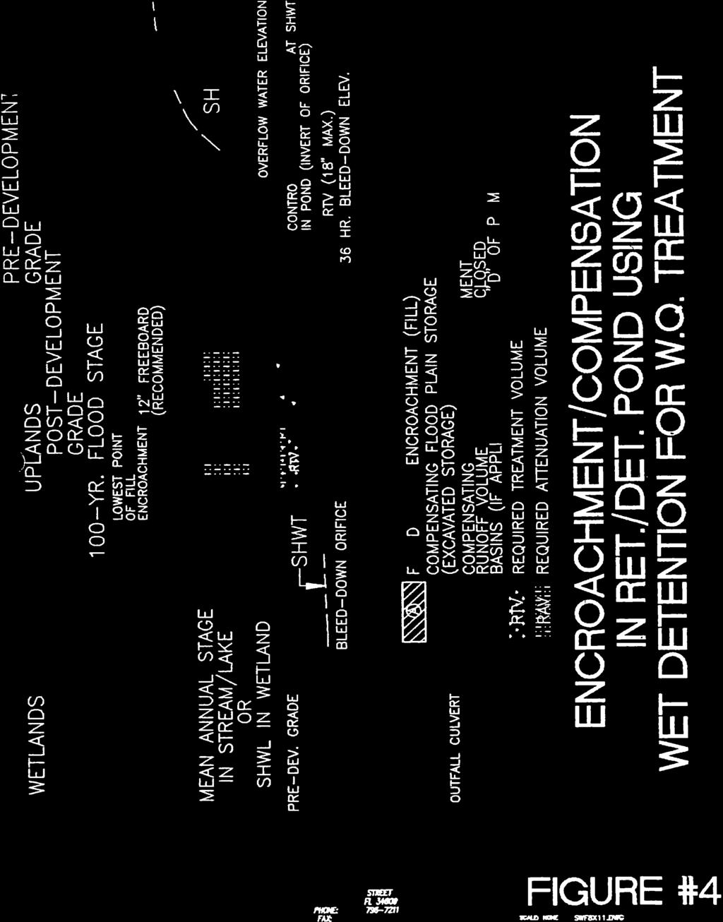
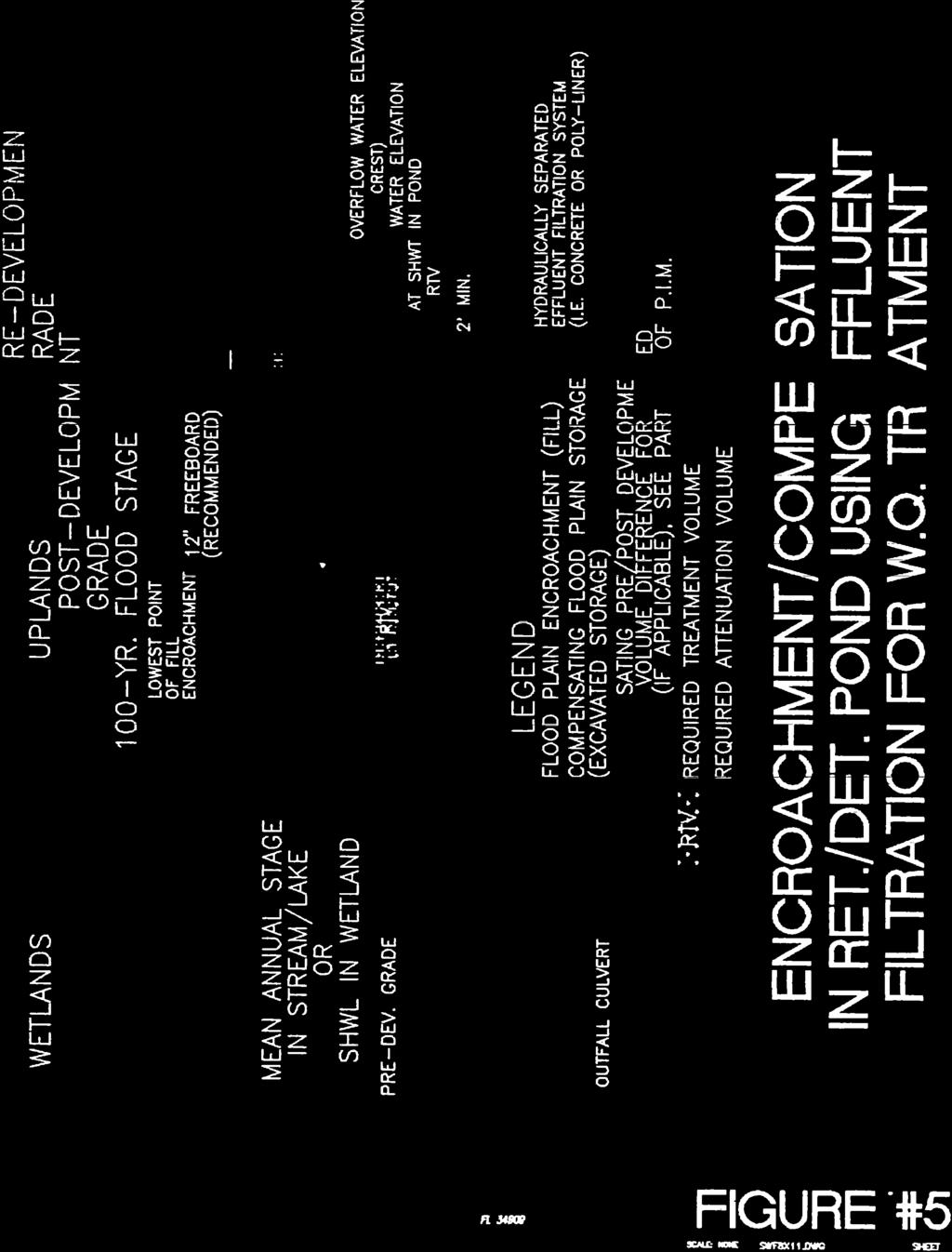
5 Littoral Zones: Wet pool volume accounts for littoral shelf (35% area at control elevation). Maintenance Berm: 15-feet wide minimum, 1:15 maximum slope. Roadside shoulders may serve as part of the maintenance berm width for contiguous ponds. Pond Slopes: 1:4 side slopes down to two-feet below control elevation and 1:2 slopes greater than 2-feet below control elevation. Outside tie down 1:4 slopes (1:3 max.) plus 2-foot offset to property line. The 25-year DHW set 1-foot below outside berm. Littoral Zones: Wet pool volume accounts for littoral shelf (35% area at control elevation). Pond top of berm elevations are to be positioned to provide a minimum of 1 foot of freeboard above the SWFWMD 25-year, 24-hour design storm peak stage. Pond Dimensional Criteria Specific to Wet Detention over Retention - Conservation Pool (Infield Ponds) Conservation Wet Pool shall be sized for water quality and 14- day residence volume below control elevation. Design pool eight-foot maximum depth. Littoral zone shall be two-foot maximum depth below control elevation. Conservation Wet Pool ponds shall include a V-notch weir sized to discharge one-half inch of runoff in 24-hours (10- inches max fluctuation above control elevation). Control elevation not lower than SHWT, nor higher than 2-feet above SHWT. Pond Dimensional Criteria Specific to Wet Detention 120-Hour Recovery (Infield Ponds) Pond Dimensional Criteria Specific to Wet Detention 120-Hour Recovery (Roadside Linear Ditches) Treatment depth 18-inches maximum above control elevation. Bottom of pond set no less than one-foot below control elevation, and provides wet pool nutrient removal as applicable. Littoral zone 3.5-feet maximum depth below overflow elevation. Wet Detention (Roadside Linear Treatment Ditches) Treatment depth 6-inches maximum above control elevation. Bottom of pond set one-foot below control elevation, and provides wet pool nutrient removal as applicable. Littoral zone 1.5-feet maximum depth below overflow elevation.
6 Linear roadside treatment ditch containment berms shall have an eight-foot wide top of berm, with a typical 1:8 berm slope away from the impoundment. The maximum top of berm height shall be no higher than six-inches below the low edge of shoulder draining to the facility. Perimeter swales shall be positioned between the right-of-way line and the treatment ditch containment berm, as needed to maintain existing offsite drainage flow patterns. SWFWMD Water Quality (Pre-application meeting agreements). Wet Detention Treatment Volume: One Inch of treatment volume, (SWFWMD ERP Applicant s Handbook Volume II, Part IV Sec. 4.1), with the following SWFWMD Water Quality Pre-application project specific agreements: SWFWMD one-inch of online wet treatment of only the area of additional pavement, including treating only the footprint of the existing I-75 lanes within the reconstructed I-75 lanes realigned for the University Parkway interchange ultimate section. Provide on-line water quality treatment of the area of additional pavement within the I-75 median, or provide equivalent treatment for the I-75 new pavement by either treating an area of existing pavement, and conversely allowing a segment of new pavement (equal to the area of treated existing) to bypass treatment, provided a net improvement of treatment (equal or greater than area of new pavement) could be demonstrated. Treatment of the University Parkway proposed DDI will require treatment of the additional pavement (in excess of the existing lanes being reconstructed within the interchange), plus the replacement of existing stormwater management facility permitted treatment volumes impacted by the reconstruction footprint. SWFWMD Pre vs. Post Water Quantity Project drains to open basins: Pre vs. Post 25YR-24HR attenuation volume above conservation pool control elevation or Wet Detention overflow weir. Pond routing design event will be based on SCS Hydrograph analysis of the 25-Year 24-Hour (8.0-inches) rainfall probability event using the SWFWMD s SCS Type II (Florida Modified) rainfall distribution. Hydrograph Peaking Factor = 256. Replace attenuation provided by existing SMF impacted by the project (existing permitted stormwater management systems are
7 modeled in the project s ICPR routing pre-condition model). Any stormwater management pond discharge received by existing stormdrain systems will be evaluated to demonstrate acceptable pre vs. post allowable high water conditions resulting from the design flows within the stormdrain system. Pre vs. Post Water Quantity Pre vs. Post water quantity analysis is performed by ICPR Hydro-dynamic modeling of the I-75 and University Parkway right-of-way coverage that will be modified in the postcondition, including contributing offsite areas. Basin boundary conditions are derived from the ICPR regional watershed models for Phillippi Creek Watershed (Sarasota County) and Braden River Watershed. (Manatee County). The regional watershed boundary conditions in the I-75 project s ICPR modeling are simulated as variable time stage or time flow boundary nodes. Pre vs. Post 25YR-24HR attenuation volume initial stage (SWFWMD Wet Detention) shall be set at the 36-hour drawdown stage for conventional water quality bleeders, and at the control elevation for conservation pool designs. Pond freeboard and allowable high water 25-year peak stage by routing the SCS Hydrograph analysis of the 25-Year-24 Hour (8.0 ) rainfall probability event using the SWFWMD s SCS Type II (Florida Modified) rainfall distribution. Pre vs. Post Nutrient Removal SQAH Pre vs. Post Nutrient Removal Wet Pool applied to WBID 1930A, Cooper Creek (Foley Creek). Not required for WBID 1937, Phillippi Creek basin as it is not nutrient impaired. Pre vs. Post Nutrient removal shall be provided by wet detention treatment permanent pool volume. Conservation pool 14-day residence volume also provides wet pool nutrient removal. House Bill 503 The SWFWMD will accept comingling of offsite stormwater while only requiring water quality treatment for the onsite increase in impervious area. This approach would require nutrient analysis to show no net increase in pollutant loadings. FDOT Chapter FAC Pre vs. Post Critical Duration Analysis Not applied.
8 Floodplain Impacts Cup-for-cup floodplain volume mitigation for loss of floodplain storage associated with project. Wet detention ponds with conservation pool control elevations set at seasonal high water elevation will be evaluated for floodplain volume mitigation credit. The Sarasota County Model and Manatee County Braden River Watershed Model will be used for establishing 100-year floodplain elevations and for demonstrating no adverse impacts from the post-condition floodplain; however, the project will not involve the Sarasota County model updating process to the Phillippi Creek Model. SWFWMD Storm Water Quality (General Criteria) This project does not directly discharge into an Outstanding Florida Water (OFW) and therefore does not require treatment for a volume 50% more than required for the selected treatment system, (SWFWMD ERP Applicant s Handbook Volume II, Part IV Sec. 4.1). Wet Detention ponds will include a minimum of 35% littoral zone, (concentrated at the outfall), no deeper than 3.5 feet below design overflow for conventional 60-hour drawdown systems) and no deeper than two feet below conservation pool control elevation. Mulching and or planting is desired but not required unless littoral zone would otherwise not be capable of supporting wetland vegetation, (SWFWMD ERP Applicant s Handbook Volume II, Part IV Sec. 4.1). Wet Detention treatment volume (conventional bleeder) will be discharged (by round bleeder >=2.76, rectangular or notched weir) and shall be totally discharged in no less than 120 hours, with no more than one-half the total volume being discharged within the first 60 hours, (SWFWMD ERP Applicant s Handbook Volume II, Part IV Sec. 4.1). Water Quality Bleed Down Mechanisms with less than six square inches of cross sectional area or two inches minimum dimension or less than 20-degrees for V-notches must include a device to eliminate clogging; baffles, grates, pipe elbows, etc. Oil Skimming Baffles will be installed on all water quality bleeder control devices and overflow weirs for basins with 50- percent or greater impervious area, or from drainage systems with inlets directly connected to impervious pavements. Poured slab should be installed under the skimmer. Wet ponds should include sumps adjacent to the inflow points and outfall control structures.
9 Stormwater / Pond maintenance / Safety Criteria Tree clusters near structures should be no closer than 50 feet apart for machinery access. Pond side slopes are desired to be no greater than 4:1. Pond side slopes greater than 4:1 will require fencing of the pond perimeter, (SWFWMD). Pond maintenance berms adjacent to the base of retaining walls shall be no less than 15-feet wide (1:8 maximum) with the Pond 25-year peak stage one-foot below the top of slope, and the low edge of berm no lower than the pond s 100-year peak stage. It is desirable to contour the pond top of bank to be curvilinear where possible. Areas subject to erosion must be stabilized with sod (certified Soda Apple free) or other suitable alternative. Pond inflow and outfall points shall include a hardened pad for scour abatement. Inflow points in wet ponds will include sumps. The use of trash screens around pond inflow structures is desirable. Pond berm elevations are to be positioned to provide a minimum of 1 foot of freeboard above the design storm peak stage. Stormwater pond outfall points of discharge will to the extent feasible provide energy dissipation and attenuated broad flow by such means as discharging into grassed spreader swales or armored outlets. Pond sites situated adjacent to the roadway or pedestrian areas will incorporate roadway safety criteria outlined within the FDOT PPM Vol. I Chapter 4.2 for Canal Condition and dropoff criteria. Pond sites will consider economical aesthetical landscape features.

10
11
12
13

14
15


16

17

18
19
20