The Lewistown Narrows. State Routes 22/322
|
|
|
- Corey Baker
- 5 years ago
- Views:
Transcription

1 The Lewistown Narrows State Routes 22/322
2
3 "The Narrows...a History of Transportation"
4 The history of transportation in the Narrows is a compelling story that begins with early man and the Juniata River. This natural gap between the Shade Mountain and Blue Mountain is strategically important to travel, development, and the economy of the region. Indian paths, wagon trails, canals, highways, and turnpikes have evolved over time moving people and goods throughout central Pennsylvania. The highway improvement project is one more chapter in this story.
5 Project Region
 A10 (2.")
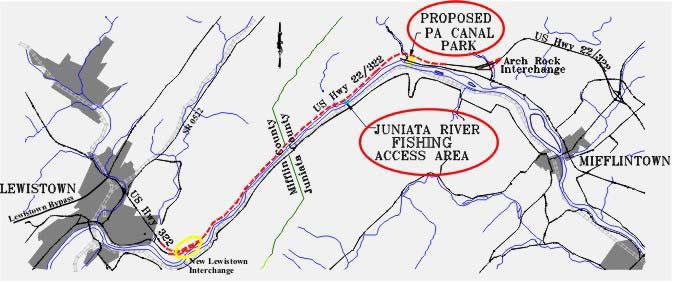
6 Project Scope Located East of Lewistown along the Juniata River, Mifflin and Juniata Counties. Entire project is 10.3 miles long and includes three construction sections A09 (6.6 miles) A10 (2.5 miles) and A11 (1.2 miles).
7 Project Area Section A09 Section A10 Section A11
8 Typical Sections The highway was designed as a 4-lane, limited access facility with two 12-foot lanes in each direction, 10-foot outside shoulders and a median that varies from 11 6 to 20.
9 Section A10 Section A11 Two interchanges were reconstructed as part of the project.

10 The Lewistown Interchange was reconfigured to accommodate the relocation of S.R. 22 North of the Borough. Section A11

11 Section A11

12 Section A11

13 Section A11
14 SR 22- A11 Location: Lewistown, Pennsylvania General Contractor: Dick Corporation Owner: Pennsylvania Department of Transportation Contract Value: $17,737,977

15 Section A10 The Arch Rock Interchange, Juniata County is a full access interchange. The upgrade of the Arch Rock interchange and the restoration of 2 miles of existing pavement is part of a separate construction section (Sec A10). Construction was completed in Fall 2003.

16 SR 22- A10

17 SR 22- A10
18 SR 22- A10 Location: Arch Rock, Pennsylvania General Contractor: Glenn O. Hawbaker Inc. Owner: Pennsylvania Department of Transportation Contract Value: $12,648,629
19 SR 22-A09 Section A09 The Narrows portion extends 6.65 miles between the Lewistown and Arch Rock interchanges. The project includes construction of a 4-lane limited access highway and environmental enhancements.

20 Aerial of Existing Roadway
21 SR 22- A09 Location: Lewistown, Pennsylvania General Contractor: Walsh Construction Company Owner: Pennsylvania Department of Transportation Contract Value: $104,360,592

22 SR 22-A09 One of the significant design challenges involved the geotechnical investigations and analyses. To determine subsurface conditions, over 40,000 L.F. core drilling was done along with seismic and ground penetrating radar investigations.

23 Global stability became an issue that required months of analyses and review by experts from federal and state government, as well as independent consultants. To assure the required factor of safety, a special wall design was developed. The wall incorporates drilled piles that protrude into competent rock layers.
24 Talus Rock Slope

25 Talus Rock Slope

26 Talus Rock Slope
27 Rock Breaking Ceremony March 18, 2004

28 Logging and Clearing

29 Erosion Control

30 Erosion Control

31
32

33
34 Typical Wall Section

35 River wall Construction

36 River wall Construction

37 Riverwall Construction
38 Eastern End of Project

39 Excavation at East End

40 Crushing Excavated Material
41 Environmental Enhancements
42 Environmental Enhancements 2.1 Acre Wetland Replacement Site PA Canal Park Picnic areas Interpretive Center Stabilized section of the PA Canal Juniata River Access Area Paved parking lot One boat launch Fishing access area for the physically challenged Old Canal House at Eastern End of Project Area


43 Wetland Construction

44 Wetland Construction
45

46

47

48 Canal Lockkeepers Hous

49 Repairs at Canal Lockkeepers House

50 Former canal system lock
 Weather Station Flashing Warning Devices High Water")
51 ITS devices that will be installed: Dynamic Message Signs (DMS) Video Monitoring Highway Advisory Radio System (HAR) Weather Station Flashing Warning Devices High Water Monitor
52 TRAFFIC CONTROL DURING CONSTRUCTION

53 Aerial of Temporary Highway Bridge

54 Temporary Bridge over Macedonia Run

55 Box Culvert Stream Diversion

56 Box Culvert Installation

57 Box Culvert Installation

58 Box Culvert Construction

59 Aerial of Mountain Excavation and Waste Site

60 Aerial of Waste/Storage Area

61 73 Acre Waste Site
62 Crushing 1,000,000 Tons
63 Blasting 1,200,000 CYD

64 Filling The Holes for the Next Blast

65 Mountain Excavation-1,800,000 CY of Excavation

66 Hitachi 1200 Excavator & Volvo 40 Ton Hauler

67 Haul Road Construction

68 Causeway Construction

69 Causeway

70 ABI Micropile Drill

71 ABI Micropile Drill

72 ABI Micropile Drill

73 IMT Micropile Drill

74 IMT Micropile Drill

75 IMT Micropile Drill

76 Fall 2004 River Flooding
77 Questions?
78