Footbridge Reconstruction Workshop #2
|
|
|
- Ambrose Evans
- 5 years ago
- Views:
Transcription

1 Footbridge Reconstruction Workshop #2 Town of Boothbay Harbor, ME July 12, 2018
2 Presentation Outline 1. Project Location and Overview 2. Footbridge History 3. Existing Conditions 4. Project Purpose and Need 5. Reconstruction Options A. Key design parameters and input received to date B. Present Conceptual Designs 6. Next Steps 7. Feedback 2

3 1. Project Location and Overview USGS Map 3

4 1. Project Location and Overview NOAA Chart 4

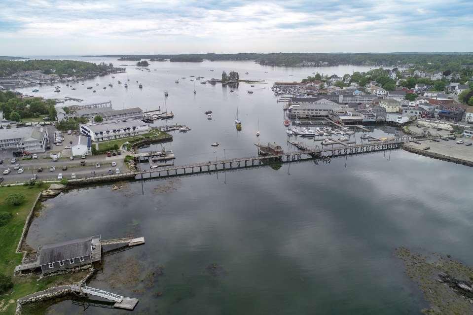
5 1. Project Location and Overview Aerial Photo 5


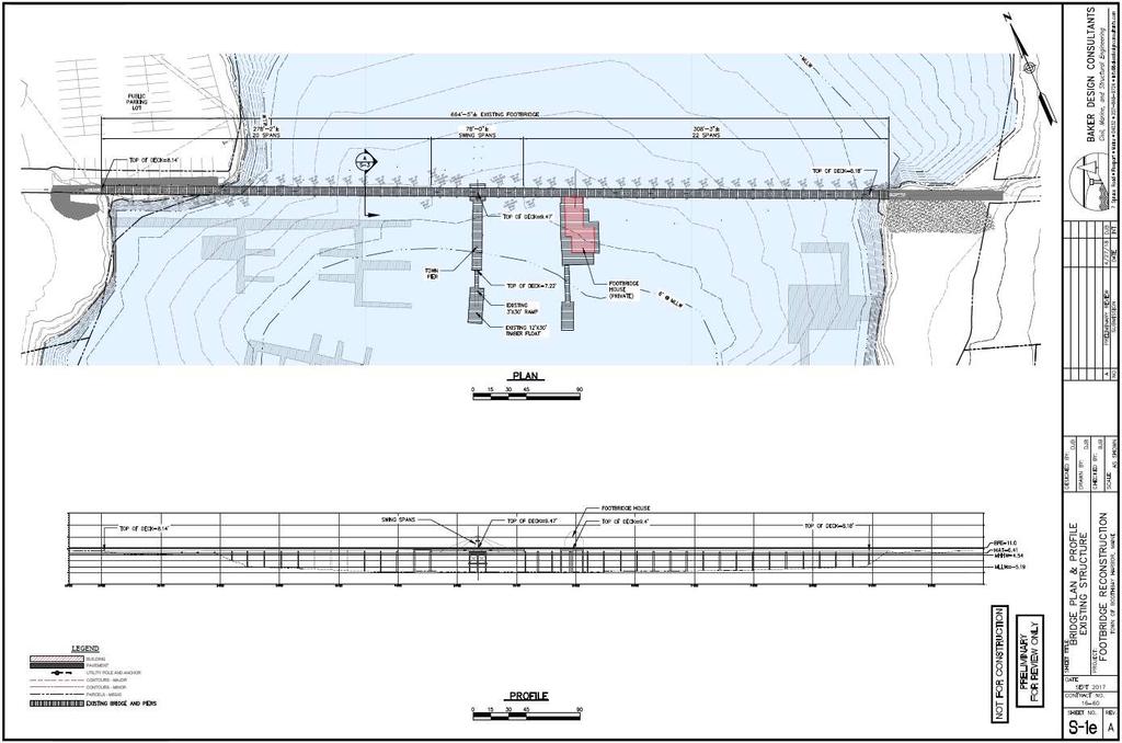
6 2. Footbridge History 1901 Original bridge constructed by Luther Maddocks at a cost of $1,500. Bridge originally had a hand-operated swing span to allow large vessels to reach head of harbor. Winter bridge damaged by icing and repaired 1928 bridge damaged by icing and repaired Originally 1,000-ft long, the bridge was at some point shortened by 300-ft by filling at ends. Parking Lots created at each end (currently Town Lot and Squirrel Island Lot) Complete reconstruction of bridge completed by Mace Carter at a cost of $135, Pile bracing and swing span repair 6

7 3. Existing Conditions 7

8 3. Existing Conditions 8

9 3. Existing Conditions 9

10 Boothbay 3. Existing Harbor Conditions Footbridge 10

11 3. Existing Conditions 11

12 3. Existing Conditions 12

13 3. Existing Conditions 13

14 3. Existing Conditions 14
15 4. Project Purpose and Need The Footbridge is an important piece of the Town of Boothbay Harbor s Infrastructure Transportation Access across harbor Access to Town dock Access to private property Destination Public access to the harbor for scenic viewing Part of the character of Boothbay Harbor Why reconstruct the footbridge? 15
16 4. Project Purpose and Need 1. Existing Structure built in Currently over 39 years old This represents a significant portion of the expected service life of a timber structure in a coastal environment Investments should consider long-term economics and feasibility 2. Swing Span USCG classifies the Footbridge as a movable bridge Not functional in recent history Per USCG, Town is responsible for opening the bridge if need arises Operation of movable bridge should be restored or the Town should work with USCG to change the bridge classification 3. Structural Capacity Code requirement for pedestrian live load is psf Superstructure rated at 50 psf live load capacity The superstructure must be capable of supporting code-required live loading 16

 = 11.")
 These values do not")
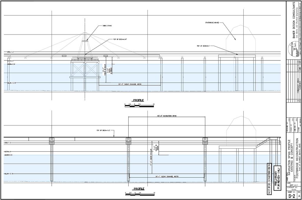
17 4. Project Purpose and Need 4. Flood Hazard Issues Structure is very low in relation to tidal and flood elevations Top of Deck ranges from 8.2 NAVD88 to 9.5 NAVD88 Base Flood Elevation (BFE) = 11.0 NAVD88 Highest Annual Tide (HAT) = 6.4 NAVD88 (Maine DEP 2017 Predictions) These values do not account for Sea Level Rise Sea Level Rise Projections from USACE per MGS 2016 Study 17


18 Top of Swing Span EL 9.47 (NAVD88) BFE = 11.0 HAT = 6.4 MHHW =
 19")
19 February 11, 2016 High Tide (Photo: LCPRC) 19
 20")
20 February 11, 2016 High Tide (Photo: LCPRC) 20
 21")
21 November 16, 2016 High Tide (Photo: LCPRC) 21
 22")
22 November 16, 2016 High Tide (Photo: LCPRC) 22

23 January 4, 2018 (Photo: Tom Woodin) 23

24 January 4, 2018 (Photo: Tom Woodin) 24

25 January 4, 2018 (Photo: Tom Woodin) 25

26 January 4, 2018 (Photo: Tom Woodin) 26
27 4. Project Purpose and Need 4. Flood Hazard Issues Structure is at significant risk of damage during flood events Opportunities: Elevate, Resist (Wet Floodproof), Combination Regulatory Requirements Town of Boothbay Harbor Flood plain Management Ordinance Development Standards M. Bridges. New construction or substantial improvement of any bridge in Zones A, AE and VE shall be designed such that: (1) When possible, the lowest horizontal member (excluding the pilings, or columns) is elevated to at least one foot above the base flood elevation; and (2) A registered professional engineer shall certify that: (a) The structural design and methods of construction shall meet the elevation requirements of this section and the floodway standards of K; and (b) The foundation and superstructure attached thereto are designed to resist flotation, collapse and lateral movement due to the effects of wind and water loads acting simultaneously on all structural components. Water loading values used shall be those associated with the base flood. O. Wharves, piers and docks. New construction or substantial improvement of wharves, piers, and docks are permitted in Zones A, AE, and VE, in and over water and seaward of the mean high tide, if the following requirements are met: Full compliance with the Floodplain Management Ordinance requires the Top of Deck Elevation to be increased by 4.5 at the Swing Span. (1)Wharves, piers, and docks shall comply with all applicable local, state, and federal regulations; and (2)For commercial wharves, piers, and docks, a registered professional engineer shall develop or review the structural design, specifications, and plans for the construction. 27

 6.")
28 4. Project Purpose and Need 5. Code Compliance Issues ADA (stairs to wharf, deck surface irregularities) Handrails (insufficient structural capacity) 6. Utilities Water, sewer, electric Swing span mechanism subject to flooding 28
29 4. Project Purpose and Need Conclusion: The most feasible solution is a Replacement of the existing footbridge 29
30 5. Reconstruction Options Design Parameters General Structural and Code Requirements Uses and users Navigational Needs Historic Considerations Geometric Structure Location and Horizontal Alignment Vertical Alignment/Elevation/Gradients Width Structure Type Type and Materials Inclusion of a movable span Features Lighting Railings Utilities Aesthetics Incorporation with Town dock and other adjacent facilities/improvements Site improvements/overlooks/landings 30
31 Design Precedents Navigation to head of harbor Pile supported timber structure Boat Landing tie-in with adjacent properties and structures

32 Design Precedents improvements at landings integrated lighting material selection proper width

33 Design Precedents curved alignment open railings

34 Design Precedents widened overlook areas Glue-Laminated Timber Construction 34

35 Access to water Landings Curved alignment Improved Landscape feature 35
36 Existing Bridge 36
37 37
38 Concept Option 1 38
39 39
40 40
41 41
42 42
43 43
44 44

45 Existing Concept Option 1 45
46 Concept Option 2 46
47 47
48 48
49 49

50 Existing Concept Option 2 50
51 Concept Option 3 51
52 52
53 53
54 54

55 Existing Concept Option 3 55
56 6. Timeline and Next Steps Workshop #2 Present preliminary design concepts Gather input on preferred concept and design details Prepare Preliminary Design Report Permitting and Final Design pending acceptance of Preliminary Design Maine DOT funding for a portion of the project is programmed for 2020 Additional funding pending 56
57 7. Feedback Some key items to consider: Preferred concept Navigation span requirements Bridge aesthetics and material preferences Overlook and Town Dock design Any other items we should be aware of Concept Option 1 Concept Option 2 Concept Option 3 57

58 Footbridge Reconstruction Workshop #2 Town of Boothbay Harbor, Maine July 12, 2018 Questions, contact: Daniel Bannon, PE, CFM Baker Design Consultants 7 Spruce Road Freeport, ME d.bannon@bakerdesignconsultants.com