New Governor Harry W. Nice Memorial Bridge (US 301) Will Pines, P.E.
|
|
|
- Eustacia Dana Williams
- 5 years ago
- Views:
Transcription


1 New Governor Harry W. Nice Memorial Bridge (US 301) Will Pines, P.E. Director of Project Development April 9,
: 2.2 miles Bridge length: 1.9 miles of two-lane bridge 2017 traffic volume: 6.")
2 Project Background Construction dates: March 1938 December 1940 Original cost to construct: $5 million Named in 1968 for Maryland Governor Harry W. Nice Length of entire facility (including bridge and approaches): 2.2 miles Bridge length: 1.9 miles of two-lane bridge 2017 traffic volume: 6.9 million vehicles (average annual daily traffic: 18,800) 2 2


3 Project Introduction Maryland Governor Larry Hogan announces funding for new Potomac River crossing 3 3
 Major rehab needed in near future (i.e., re-decking) very problematic, and a cost driver in the LCCA timing 4 4")
4 Purpose and Need From NEPA Documents: Geometric inconsistencies Safety issues Traffic capacity limitations Traffic impacts due to incidents, maintenance & wide-loads Life Cycle Cost Analysis (LCCA) Major rehab needed in near future (i.e., re-decking) very problematic, and a cost driver in the LCCA timing 4 4


 Some spalling & cracking,")
5 Purpose and Need PAINT SUPERSTRUCTURE STEEL Not in very good shape, 10 year life at most. Some section loss, Condition Rating = 5 (Fair) DECK SUBSTRUCTURE 30 year old wearing surface nearing end of its lifespan, Condition Rating = 5 (Fair) Some spalling & cracking, Condition Rating = 5 (Fair) 5 5


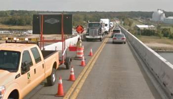
6 Purpose and Need SAFETY ISSUES 6 6
 July 2016 Virginia")
 July")
7 Purpose and Need CURRENT TRAFFIC CONDITIONS - ROUTINE SUMMER, WEEKEND CONGESTION Average Friday (Southbound) July 2016 Virginia Maryland ~3.5 Miles MPH Rolling Queue Average Sunday (Northbound) July 2016 Virginia Maryland ~3.5 Miles <10 MPH Standing Queue 7 7


8 Purpose and Need AUGUST WEEKENDS - UP TO 4 MILE BACKUPS Friday Aug. 12 th Friday Aug. 12 th MD Approach SB Sunday Aug. 14 th VA Approach NB Sunday Aug. 14 th 5 mph Friday Aug. 19 th 8 8


9 Purpose and Need MAINTENANCE AND INSPECTION LIMITATIONS 9 9


10 Why Practical Design? D

11 Goals? 11 11

12 Divisional Needs? 12 12

13 MDTA Agency Needs? 13 13


14 Statewide Needs? 14 14

15 Be smart about your part! 15 15

16 What is Practical Design?

17 Practical Design MODIFIED ALTERNATE 7 Unaffordable NEPA Design wider than the Virginia approach highways 17 17
 lanes")

18 Practical Design MDTA S FRANCIS SCOTT KEY BRIDGE Four (4) lanes with barrier separation, similar to New Nice Bridge Options 18 18


19 Practical Design BRIDGE TYPE COST EVALUATION Pre-TS&L (Type, Size and Location) Bridge alternatives analysis completed based on reduced span length: I-95 ETL Ramps Max. Spans 290 feet 19 19
20 Project Goals 1. Cost Complete the project at or below the total construction budget, while minimizing life-cycle costs. 2. Schedule Fully open all four (4) lanes to traffic on the new bridge by December 15, 2022 and minimize the total days of project construction. 3. Safety Provide a safe toll facility with zero fatalities and serious injuries for workers and the public during and after construction. 4. Durability Integrate high quality design, construction and operational aspects to deliver a durable, functional bridge achieving the minimum 75 year service life requirements. 5. Mobility Minimize customer travel delays during and after construction


21 Project Schedule 21 21

22 Project Budget Cost Elements: New Bridge Construction Infrastructure on new bridge and temporary access Administrative Planning, preliminary engineering, CMI, program and financial management Approach Roadways Infrastructure for roadway, signs, lighting, cameras, gantries, traffic control, utilities Campus Improvements Modifications to administrative building and maintenance facility Environmental Park mitigation and other environmental work Existing Bridge Demolition Removal of existing structure once new bridge is constructed Right of Way Acquisition costs for all required parcels 22 22

23 Project will include Federal DBE and OJT Programs Opportunities Engineering and Design Construction Services DBE / OJT Program 23

24 The following include a sample of the main work items anticipated for this contract: Approximately 1.9 Mile Bridge Structure across the Potomac River with an opening for Navigational Passage Approximately 1 Mile of Highway Realignment in both Maryland and Virginia Realignment of Orland Park Road and Roseland Road Drainage and Stormwater Management Traffic Signing and ITS Equipment Tolling Infrastructure Anticipated Work Items 24
 Navigational Beacons Utility Relocations Environmental Mitigation and Landscaping Temporary Construction Access Structures Demolition of the Existing Bridge")
25 Anticipated Work Items (cont d.) Navigational Beacons Utility Relocations Environmental Mitigation and Landscaping Temporary Construction Access Structures Demolition of the Existing Bridge Support for Regulatory Approvals and Permitting Associated Engineering Design, Geotechnical Studies, Earthwork, Supplies, and Hauling 25

26 Project Layout 26 26

27 Project Layout 27


28 Project Land Work 28


29 Bid- Alternate Approach 29

30 Bridge Design 30


31 Bridge Type Steel Segmental Concrete 31

32 Geotechnical Historical Information 32

33 A Survey of potential submerged hazards found that there is virtually no risk of encountering Munitions of Concern or Unexploded Ordinances from the Dahlgren Naval Support Facility Geotechnical Subsurface Investigation Program 27 River SPT Borings to 150 to 250 feet 20 Maryland Shore Land SPT Borings 10 Virginia Shore Land SPT Borings Seismic 2 River Locations per ASTM D7400 In-Situ Testing Program Geotechnical Program and Results 13 River Cone Penetrometer Tests with Pore Pressure Dissipation Tests and Seismic Testing 4 Land Cone Penetrometer Tests with Pore Pressure Dissipation Tests and Seismic Testing 4 Dilatometer Tests; 2 Rover and 2 Land 30 Pressuremeter Tests In 2 River Borings 21 Field Vane Shear Tests at 2 River Boring Locations 33
 Geologic Setting Disclosed By Geotechnical Subsurface Investigation Program Holocene (MD, VA and Potomac")
34 Geotechnical Program and Results (cont d) Borings - Field work completed May 2016, Geotechnical Data Report compiled. Test Piles - Accomplished small test pile program in February 2016 (2 24 steel pipe piles) Geologic Setting Disclosed By Geotechnical Subsurface Investigation Program Holocene (MD, VA and Potomac River) Pleistocene (Maryland Point on MD Side and Sedgefield on VA Side) Miocene Age Calvert Formation (VA Side) Nanjemoy (MD, VA and Potomac River) Marlboro Clay (MD, VA and Potomac River) Aquia (MD, VA and Potomac River) 34

35 Existing Landside and Hydrographic Surveys 35


36 Utility Investigations Completed level C Utility Mosaic Basemap Confirmed AT&T under river crossing well clear of proposed new bridge location 36

")

37 All Electronic Tolling (AET) ICC/MD 200 I-95 ETLs ICC/MD
38 Questions/ Open Discussion Stay