Hurricane Storm Surge Risk Analysis for the U.S.
|
|
|
- Ginger Turner
- 5 years ago
- Views:
Transcription


1 Hurricane Storm Surge Risk Analysis for the U.S. H. E. Gene Longenecker, III Physical Scientist FEMA Region IV Earthquake Program Manager HAZUS Conference, Indianapolis, IN
2 Overview Concept for Region IV s Coastal Flood Loss Atlas (CFLA) project Background and methodology for the CFLA Applications of the CFLA
3 CFLA Concept Unite HAZUS risk/loss analyses with the Hurricane Program for response and mitigation settings by incorporating best available data and modeling for hurricane storm surge Piggyback on the scientific storm surge modeling expertise of NOAA and SLOSH SLOSH because it s readily available, independently validated, accurate, easy to transform, and has applications in pre-landfall forecasting, surge zone delineation, and evacuation/vulnerability studies
4 CFLA Concept Employ FEMA s disaster data from JFOs and/or analyse existing data where available (NFIP, RSDE, Repetitive Losses, etc ) Place bookends around losses to have a readily available dictionary of possible, expected conditions for post-landfall strategies Improve the HAZUS Coastal Flood Loss Model capabilities and quality
5 Background & Methods 2005 Hurricane Season HAZUS Coastal Analyses for Hurricane Wilma completed in MR1/MR2 prior to landfall Coarse estimate based on Saffir-Simpson hurricane surge estimates at the time Only able to complete analysis for Collier County, FL Excessively lengthy processing times SLOSH data available, but only used as overlay and extra information
6 Background & Methods Hurricane Seasons Opportunity to develop better surge analysis capabilities using GIS and HAZUS Developed SLOSH depth grid methodology using forecast advisories and MOM ( Maximum of Maximums per hurricane category) SLOSH water surface elevation minus DEM Also began extensive testing of the HAZUS Coastal Flood Model methodology in my master s thesis
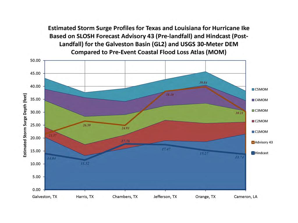
7 Background & Methods Findings from my master s thesis indicated the HAZUS Coastal Module had some issues varying stillwater elevations Depth grid methodology deployed for Hurricane Dean s landfall near Brownsville, TX Release of HAZUS MR3 allowed incorporation of user-defined depth grids Supplied SLOSH MOM depth grids to HAZUS to place a low- and high-end estimate around potential impacts

8 Level 1 Results


9 Background & Methods 2008 Hurricane Season Developed and released SOP for Coastal Flood Hazard & Loss Analysis incorporating SLOSH MOM and forecast advisories Prepped all SLOSH basins for NAVD88/USGS NED compatibility Regions 4, 8, and the HQ MAC Deployed methodology for Hurricanes Gustav & Ike
10 Background & Methods 2009 to Present Hurricane Season: Comprehensive model evaluation study (L1-3) for Hurricane Katrina damage datasets, coastal depthdamage relationships, DEM sensitivity studies (3m- 30m), SLOSH and HWM analyses Change analysis and depth grids for SLOSH 1.47 and 1.61 MOM for entire US East Coast MR3 and MR4 (patch 1) analyses USGS 30-meter NED for Regions 4 & 6
11 Sensitivity Analyses Damage % Damage % Sensitivity Analysis for RSDE Damage Estimation for Hancock Harrison County 1SF7 1SF2 1SF1 Using HWM 3m, HWM 30m, SLOSH 3m & USGS 30m Depth Grids Depth ( ( feet) feet) HWM3M_DMG HWM30M_DMG SLOSH3M _DM G USGS30M_DMG


12

13 Data Intensity Concept ~90-meter ~30-meter ~10-meter ~1-meter Less information Level 1 Analysis raster resolution equivalence More information Level 3 Analysis
14 Level 3 Results H AZUS Estimated Damages v. Observed Damages & Assigned Damage Function H ancock RSDE 1SF7 (N = 4,732) & Fourier Series Regression Model (R 2 = ) Pearson Correlation of H AZUS & Observed Damages: Damage % Distance to Shore (miles) Depth (feet ) HAZUS Estimate Observed Damage 95% Low RSDE Class DDF 95% High Shoreline Distance

15
16
17
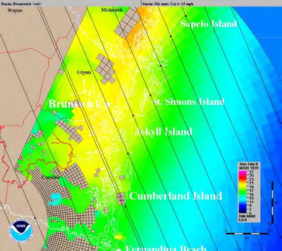
18 Applications of CFLA Florida incorporated some estimations/analyses from CFLA (MR3) in their 2010 Enhanced State Mitigation Plan First estimation of populations/distributions vulnerable to hurricane storm surge Provided storm surge loss scenarios for Glynn County, GA Cat 3 Hurricane Julia exercise Jekyll Island, Brunswick, GA area

19 Applications of CFLA
20

21

22 In Development Improving interagency relationships toward enhanced collaboration, shared mission USGS, USACE, CSC NOAA Storm Surge Team - NHC Improving our understanding of risk and vulnerability USC Social Vulnerability Index Hurricane Evacuation Studies Reduce operational GIS demand and potential for errors
23 Questions?