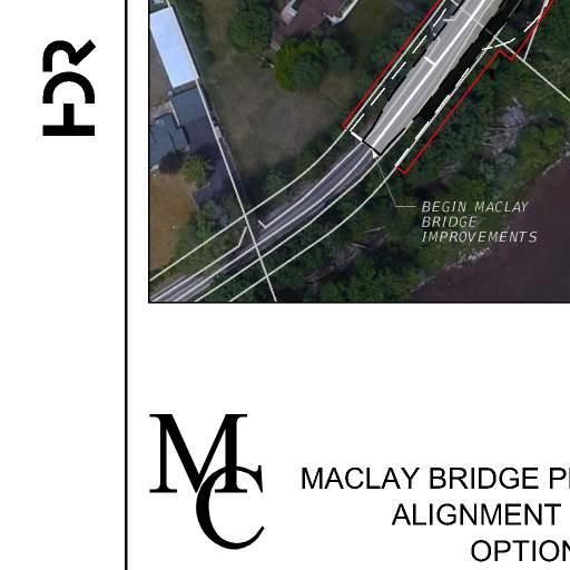
Maclay Bridge Preservation Alternatives Analysis
|
|
|
- Sheila Owen
- 5 years ago
- Views:
Transcription
 UPN 6296000 August 30, 2018")
1 Maclay Bridge Preservation Alternatives Analysis Bitterroot River W of Missoula BR 9032(65) UPN August 30, 2018
2 Maclay Bridge Preservation Alternatives Analysis August 30, 2018 Table of Contents Introduction... 2 Maclay Bridge Preservation - Option Maclay Bridge Preservation - Option Maclay Bridge Preservation - Option Conclusions... 9 Appendix A: Conceptual Details for Preservation Alternatives Appendix B: Cost Estimates 1
3 Maclay Bridge Preservation Alternatives Analysis August 30, 2018 Introduction The purpose of this report is to summarize the evaluation of alternatives to rehabilitate and/or preserve the existing Maclay Bridge. This report is intended to support the National Environmental Policy Act (NEPA) and Montana Environmental Policy Act (MEPA) environmental document and Section 4(f) Evaluation prepared for the proposed South Avenue Bridge by analyzing the validity, reasonableness, and feasibility of rehabilitation options for Maclay Bridge. Since the project began in 2015, the existing Maclay Bridge has been listed on the National Register of Historic Places (NHRP), thus afforded protection under Section 4(f) of the U.S. Department of Transportation Act of 1966 (49 USC 1653(f)), and the feasibility of preserving the existing bridge must be analyzed as part of the environmental documentation process in compliance with 49 USC 303(c) of the Section 4(f) regulation, which contains the declaration of policy that allows the Secretary of USDOT to approve a program or project requiring the use of Section 4(f) resource only if (1) there is no prudent and feasible alternative to using the land, and (2) the program or project includes all possible planning to minimize harm to the Section 4(f) resource resulting from the use. This evaluation of rehabilitation alternatives will also be used by the Montana Department of Transportation (MDT) and the Montana State Historic Preservation Office (SHPO) to identify whether the structural modifications of the rehabilitation options would affect NHRP eligibility of Maclay Bridge. The work summarized in this report was focused on identifying and evaluating options for rehabilitating and/or preserving the existing bridge in a manner that fulfills the project purpose and need and related design criteria. Refer to the Final Maclay Bridge Planning Study, March 22, 2013, and the Bridge Type, Size, and Location (TSL) Report, October 24, 2016 for more detailed information related to the Purpose and Need and project design criteria respectively. The Maclay Bridge Alliance (MBA) is acknowledged as a Consulting Party to the project. The MBA brought forward several options to rehabilitate and preserve the existing Maclay Bridge which were presented to the public on September 20, As part of the Maclay Bridge preservation feasibility study summarized herein, those options brought forward by MBA that meet the project purpose and need were evaluated. The following table lists the preservation options that were included in MBA s presentation and whether or not they were evaluated by the project team with this study: Table 1: Maclay Bridge Alliance (MBA) Bridge Rehabilitation Options Option Description Included in this evaluation? 1 Rehabilitate the main span Parker through truss with arches for 36 ton load capacity. Replace the pony truss concrete approach spans with a new single span. 2 Widen the main span truss to 2-lanes and upgrade the load capacity. Replace the pony truss and concrete approach spans with a new single span. 3 Build a new, one lane Parker through truss bridge parallel to the existing rehabilitated Parker truss bridge. 4 Construct a new 2-lane concrete or steel beam bridge parallel to the existing Parker through No This option does not meet the project purpose and need since it only provides for one lane of traffic. Yes Yes Although this work will consider other truss types for the new structure. No The option to replace the existing bridge at the existing location was eliminated as part of the 2013 Maclay Bridge Planning Study. This 2
4 Maclay Bridge Preservation Alternatives Analysis August 30, 2018 truss bridge rehabilitated for bike/pedestrian access. 5 Replace the existing Parker through truss bridge with a new, similar, wider 2-lane Parker through truss bridge. alternative would have the same impacts as other similar options evaluated in the planning study. No The option to replace the existing bridge at the existing location was eliminated as part of the 2013 Maclay Bridge Planning Study. Another alternative to preserve the existing Maclay Bridge in place as a local access or pedestrian structure was also included in this evaluation. This option was not included in MBA s presentation, but would avoid an impact to the Section 4(f) property while allowing the project Purpose and Need to be fulfilled with a new bridge at South Avenue. The following options to preserve the existing Maclay Bridge were evaluated as part of this study and are described in more detail in the following sections: Option 1: Preserve the existing Maclay Bridge in place as a local access or pedestrian bridge to avoid a Section 4(f) property impact, and construct a new bridge at South Avenue that fulfills the project Purpose and Need. Option 2: This option corresponds to MBA s Option 2 listed in Table 1 and would involve rehabilitating and widening the existing bridge as needed to fulfill the project purpose and need, at the existing location. Option 3: This option corresponds to MBA s Option 3 listed in Table 1, and would involve rehabilitating the existing single lane bridge to preclude posting, without widening, and constructing a new single lane structure adjacent to the existing bridge. Maclay Bridge Preservation - Option 1 Description: The existing Maclay Bridge would be preserved in place as a local access or pedestrian bridge to maintain the historical status. To fulfill the project purpose and need, a new 2-lane bridge at South Avenue would be constructed. Increasing the load capacity or rehabilitation of the existing bridge to extend useful service life is not considered a requirement for this option. Should the existing bridge be converted to a pedestrian bridge, the railing should be upgraded or replaced, and signage and barriers to physically close the bridge to vehicular traffic would be required. See Appendix-A for existing bridge layout. Impacts and Considerations: 1. The existing Maclay Bridge does not provide adequate freeboard over the river and is at risk during a flood event. The intermediate piers are misaligned with the direction of flow. The as-constructed details and condition of the existing bridge foundations below water are uncertain and could be vulnerable to scour. 2. A new bridge at South Avenue is required to meet the project purpose and need. Current hydraulic modelling is based on the existing Maclay Bridge being removed. Additional hydraulic modelling and assessment of floodplain impacts will be required if the Maclay Bridge is not removed. 3. Current hydraulic analysis defining floodplain impacts assume that Maclay Bridge will be removed. Hence, the mitigation to floodplain risk provided by the removal of the bridge would be negated. 3
5 Maclay Bridge Preservation Alternatives Analysis August 30, The County will continue to have maintenance responsibility for the bridge. Access, safety, and liability issues should be addressed if the bridge is converted into a bicycle pedestrian structure. Preliminary design for converting the approaches and existing bridge to a pedestrian facility are outside the scope of this study. Estimated Cost: The costs associated with preserving the existing bridge in place as part of this project were not calculated. The new South Avenue Bridge project would still move forward and the initial project costs to sign the roadway to preclude through traffic or to revise the structure for pedestrian use are likely minimal. However, the costs to mitigate floodplain risk or scour risk could be significant. Defining what mitigation measures are needed and the associated costs are outside the scope of this study. Maclay Bridge Preservation - Option 2 Description: This option involves rehabilitating the existing bridge to the extent necessary to fulfill the project purpose and need at the existing location. The existing bridge would be widened to accommodate two lanes of traffic with a pedestrian walkway added along one side. The Parker through truss main span would be widened to include two traffic lanes and also structurally modified and strengthened to preclude load limit posting. A 28-ft roadway width has been assumed for this option which is the minimum acceptable off-system bridge width per MDT standards. Since this option would require near complete disassembly of the through truss, upgrading the capacity to HS-20 loading would be included. The eastern pony truss and concrete approach spans would be replaced with a new, single span truss, though not necessarily a Parker type truss. Further widening the bridge, or providing a cantilevered shared use path with a width similar to that proposed for the new South Avenue Bridge alternative is likely not structurally feasible for this alternative. Therefore, for the purpose of determining costs, a 5-foot wide cantilevered walkway was assumed. Replacement of the existing asphalt infill deck with a concrete deck was also assumed for the cost estimate. See Appendix-A for concept level details for this option. Impacts and Considerations: 1. Significant structural modification and strengthening of the existing Parker through truss is required. Strengthening could be accomplished by the addition of a superimposed steel arch which would limit the amount of modification to the existing truss elements and this method has been assumed for cost estimating purposes. Replacement of the floor beams and stringers would be required to accommodate 2 traffic lanes and the greater width between individual trusses. 2. Widening of the existing foundations is not practical. For this option all of the foundation units would be removed and replaced with two new abutments and a central pier. Justifications for this assumption include: 1.) the width of the widened bridge and loading on the foundations will be at least double that of the existing bridge, 2.) the central pier will need to support both the existing main span and the new approach span, 3.) the load carrying capacity and condition of the foundation support elements are unknown and are therefore considered unreliable for safe support of substantially greater loads, and 4.) rehabilitation/strengthening of the existing foundations to the point where they can 4
6 Maclay Bridge Preservation Alternatives Analysis August 30, 2018 adequately support the loading is not cost effective compared to replacement. New foundation units supported on concrete drilled shafts were assumed for cost estimating purposes. Concrete wall piers supported on piles are also a possibility, with cost being comparable to that of foundations on drilled shafts. 3. Significant modification to the existing Parker truss span is required for this alternate to meet the project purpose and need which may preclude its classification as a historic resource. 4. Current hydraulic analysis defining floodplain impacts assume that Maclay Bridge will be removed. Hence, the mitigation to floodplain risk provided by the removal of the bridge would be negated. 5. Removal of the existing intermediate piers on the east approach could serve to increase the conveyance at the existing bridge site. However, the new center pier would be misaligned to the direction of flow since the truss cannot be widened on a skew, decreases the conveyance when compared to the existing center pier. Furthermore, this configuration presents an elevated risk for scour and accumulation of debris at the center pier. Additional hydraulic analysis is necessary to fully assess the impacts. 6. Additional width of the structure will result in further encroachment in the floodway since it is not feasible to widen the bridge parallel to the river. Any resultant rise in the 100-year water surface elevation will require mitigation. Increasing the overall span length of the bridge could aid in mitigating the water surface rise, however, performance of hydraulic analyses is not included in the scope of this study. 7. Due to the change in the hydraulic characteristics of the bridge, the project will require a Certified Letter of Map Revision (CLOMR) prior to initiation of construction and a Letter of Map Revision (LOMR) within 6 months after construction is completed. 8. In this case of structure rehabilitation, it is not possible to fully achieve the level of improvements that could otherwise be provided with a new structure. Compared to a completely new structure, reduced service life should be expected since many of the existing structure components would be reused. 9. It is anticipated that the overall depth of the new deck and floor framing will be approximately one foot greater than that of the existing. To maintain the same vertical clearance between the superstructure and the 100 year flood (freeboard), the finished profile grade of the rehabilitated bridge would be set approximately one foot higher than existing. Additional coordination with Missoula County would be necessary to determine freeboard requirements for this option. 10. The existing roadway would be widened and realigned to connect to the existing widened bridge. Significant realignment of the west approach roadway is necessary to improve safety and meet current design standards. 11. Retaining walls might be necessary along the river side of River Pines Road to support the wider roadway and prevent encroachment into the river or to limit property impacts. However, special measures for retaining the roadway were not evaluated with this analysis. 12. Existing overhead power lines are located south of the existing bridge. Relocation of these power lines will likely be required and the related costs and impacts have not been determined with this study. 5
7 Maclay Bridge Preservation Alternatives Analysis August 30, A gas regulator station is located at the east bridge approach. Relocation of this facility may be required and the related costs and impacts have not been determined with this study. 14. This alternative requires acquisition of approximately 4.9 acres of existing right of way to accommodate realignment of River Pines Road and the connection on the east approach. Relocation of five (5) residences would also be required. 15. This alternative will require a road closure and detour during construction in order to widen and rehabilitate the existing bridge and replace the southern approach spans. Estimated Cost: The estimated construction cost for this option is as follows: Table 2: Maclay Bridge Preservation - Option 2 Cost Estimate Estimated Cost (2018 Dollars) Option 2 Bridge Cost (incl. remove existing structure) $ 5,550,000 Roadway Approach Cost $ 597,000 Mobilization (18%) $ 1,106,000 Subtotal $ 7,253,000 Contingencies (35%) $ 2,539,000 Construction Engineering (15%) $ 1,088,000 Subtotal Construction Costs (2018 Dollars) $10,880,000 Right of Way Acquisition Cost (excluding relocation) $ 1,670,000 Total Estimated Cost Option 2 (2018 Dollars) $12,550,000 The estimated cost to strengthen and widen the existing truss span was based on preliminary engineering to size replacement members for the new floor system (floor beams and stringers) and a similar project where a superimposed steel arch was used to strengthen an existing truss. Unit prices were established based on recent bid history and the specific characteristics for this project to determine the overall bridge and roadway subtotal costs. A 35% contingency was included in accordance with the MDT Cost Estimation Procedures document to account for the level of design and the higher risk associated with a bridge rehabilitations project. The cost summary above does not include any additional cost for engineering design or utility relocation. Relocation costs could be significant and are not included in the cost summary. See Appendix-B for bridge and roadway detailed cost estimates. Maclay Bridge Preservation - Option 3 Description: This option involves rehabilitating the existing single lane bridge to preclude posting, without widening, to carry westbound traffic and constructing a new single lane structure adjacent to the existing bridge to carry eastbound traffic. The existing bridge is currently posted at 11-tons, and is governed by the pony truss span. Although the Parker through truss main span does not meet current design loading requirements, the span s load rating is such that posting is not required by the MDT Bridge Inspection and Rating Manual. Therefore, for the purpose of this study, rehabilitation would only include replacing the existing pony truss and concrete approach spans with a new, single span truss, though not necessarily a 6
8 Maclay Bridge Preservation Alternatives Analysis August 30, 2018 Parker type truss. The existing Parker through truss main span would be rehabilitated to extend useful service life, including replacing the bearings, replacing the existing asphalt infill deck with a concrete deck, cleaning and painting the existing floor framing and splash zones of the truss verticals, and installing crashworthy barriers along each side. The new single lane, eastbound structure would consist of two truss spans, though not necessarily Parker type trusses. The new eastbound bridge would be designed to meet current loading requirements. The structure would also provide for an 8-foot wide shared use path. It is anticipated that the overall depth of the deck and floor framing of the new eastbound structure will be approximately one foot greater than that of the existing bridge. To maintain the same vertical clearance of the superstructure low steel above the 100 year flood and to facilitate connection to the divided roadway approaches, the finish profile grade of both the new and existing structures would be set approximately one foot higher than existing. See Appendix-A for concept level details for this alternate. Impacts and Considerations: 1. For this option it was assumed that the existing west abutment would be used in place to support the existing Parker truss main span, with the top of the abutment stem wall being raised approximately one foot. The abutment would be lengthened to also support the new eastbound structure. If this alternate were to advance, a more detailed condition assessment of the existing abutment would be required to validate widening rather than replacement. 2. Replacement of the existing east approach spans has been assumed for the purpose of estimating cost. Some reduction in cost with this option would be realized if it were decided to leave these spans in place. Additional condition assessment of those spans, the foundations, and hydraulic impacts should be performed if the east approach spans are left in place. 3. Widening of the existing center pier and east abutment is not practical. A new east abutment and a central pier would be required and could support the new eastbound structure and existing westbound Parker truss span. The central pier will need to support both the existing main span and the new westbound approach span, and the load carrying capacity and condition of the existing foundation support elements are unknown and are therefore considered unreliable for safe support of substantially greater loads. New foundation units supported on concrete drilled shafts were assumed for cost estimating purposes. Concrete wall piers supported on piles are also a possibility, with cost being comparable to that of foundations on drilled shafts. 4. With this option, the overall bridge span could not be shifted east or west to avoid potential conflicts with below grade remnants of the existing foundations during construction which increases the risk and associated cost of the foundation construction. 5. In this case of structure rehabilitation, it is not possible to fully achieve the level of improvements that could otherwise be provided with a new structure. Compared to a completely new structure, reduced service life should be expected since many of the existing structure components would reused. 7
9 Maclay Bridge Preservation Alternatives Analysis August 30, The westbound bridge, which would reuse the existing Parker truss span, would not rate adequately for all legal load configurations. Although load limit posting of the bridge is precluded based on current policy, heavier loads such as a water tender might be advised to use the eastbound bridge to cross the river to avoid damaging the existing span. The additional cost to upgrade the existing Parker truss span load capacity was not estimated as part of this study. 7. Although only minor modifications to the Parker truss span are proposed with this option, there are significant modifications to the overall crossing. Whether or not the modified bridge would still be eligible for the historic register is unknown. 8. Current hydraulic analysis defining floodplain impacts assume that Maclay Bridge will be removed. Hence, the mitigation to floodplain risk provided by the removal of the bridge would be negated. 9. Removal of the existing intermediate piers on the east approach could serve to increase the conveyance of the bridge. However, the new center pier would be misaligned to the direction of flow since the truss cannot be widened on a skew, decreasing the conveyance when compared to the existing center pier. Furthermore, this configuration presents an elevated risk for scour and accumulation of debris at the center pier. Additional hydraulic analysis is necessary to fully assess the impacts. 10. Addition of the upstream bridge will result in further encroachment in the river and floodway and any resultant rise in the 100-year water surface elevation will require mitigation. The encroachment on the proposed upstream side will result in a sever contraction that in turn will increase the contraction scour through the section. Increasing the overall span length of both bridges could aid in mitigating the water surface rise and scour issues, however, performance of hydraulic analyses is not included in the scope of this study. 11. Due to the change in the hydraulic characteristics of the bridge, the project will require a Certified Letter of Map Revision (CLOMR) prior to initiation of construction and a Letter of Map Revision (LOMR) within 6 months after construction is completed. 12. The existing roadway would be widened and realigned to connect to the existing widened bridge. Significant realignment of the west approach roadway is necessary to improve safety and meet current design standards. 13. Existing overhead power lines are located south of the existing bridge. Relocation of these power lines will likely be required and the related costs and impacts have not been determined with this study. 14. A gas regulator station is located at the east bridge approach. Relocation of this facility will likely be required and the related costs and impacts have not been determined with this study. 15. Retaining walls might be necessary along the river side of River Pines Road to support the wider roadway and prevent encroachment into the river. However, special measures for retaining the roadway were not evaluated with this analysis. 16. This alternative requires acquisition of approximately 6.5 acres of existing right of way to accommodate realignment of River Pines Road and the connections on the east and west approaches. Relocation of six (6) residences would also be required. 17. This alternative may require a road closure and detour during construction. 8
10 Maclay Bridge Preservation Alternatives Analysis August 30, 2018 Estimated Cost: The estimated construction cost for this option is as follows: Table 3: Maclay Bridge Preservation - Option 3 Cost Estimate Estimated Cost (2018 Dollars) Option 3 Bridge Cost (incl. remove existing structure) $ 6,111,000 Roadway Approach Cost $ 664,000 Mobilization (18%) $ 1,220,000 Subtotal $ 7,995,000 Contingencies (35%) $ 2,798,000 Construction Engineering (15%) $ 1,199,000 Subtotal Construction Costs (2018 Dollars) $11,992,000 Right of Way Acquisition Cost (excluding relocation) $ 2,070,000 Total Estimated Cost Option 3 (2018 Dollars) $14,062,000 Unit prices were established based on recent bid history and the specific characteristics for this project to determine the overall bridge and roadway subtotal costs. A 35% contingency was included in accordance with the MDT Cost Estimation Procedures document to account for the level of design and the higher risk associated with a bridge rehabilitations project. The cost summary above does not include any additional cost for engineering design, utility relocation, or costs to increase load capacity of the existing Parker truss span. Relocation costs could be significant and are not included in the cost summary. See Appendix-B for bridge and roadway detailed cost estimates. Conclusions The Maclay Bridge Preservation Option 1 which involves preserving the existing structure in place while building a new bridge on South Avenue to meet current design standards would fulfill the project purpose and need and appears to be the most practical and cost effective option to preserve the Maclay Bridge if that becomes a project criterion. Minimal construction cost would be needed to close the roadway to through traffic or convert the structure to a pedestrian facility. However, the liability and long term maintenance associated with preserving the existing bridge, and evaluation of floodplain risk/mitigation requires consideration outside the scope of this study. The estimated total cost to provide a new bridge over the Bitterroot River at South Avenue is approximately $12.8M (2018 dollars) which includes an estimated $12.6M for bridge and roadway construction cost and $200K for right of way. The estimated total costs for rehabilitation Options 2 and 3 are approximately $12.6M and $14.1M respectively. However, the right of way costs for Option 2 and 3 do not include additional costs associated with relocation of residents, while the South Avenue alignment will not require any resident relocation. Although rehabilitation appears to result in a lower construction cost, rehabilitation does not appear to be cost-effective or practical based on the impacts and additional considerations summarized in the previous sections of this report. Retrofit of the existing bridge to meet the project purpose and need does not appear to be a practical option. 9
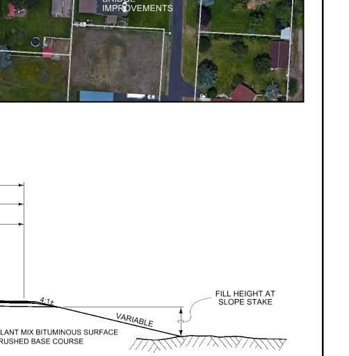
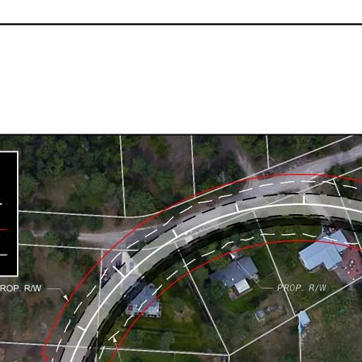
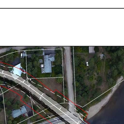
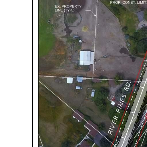
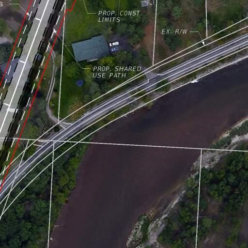
11 Appendix A: Conceptual Details for Preservation Alternatives

12
13
14
15
16
17 Appendix B: Cost Estimates
18 Prepared By: Missoula County Preliminary Construction Cost Estimate for South Avenue over Bitterroot River in Missoula Maclay Bridge Alternatives - Option 2 Job No. Computed ACW Date 6/27/2018 Spans: 181 ft ft = 342 ft Checked BKC Date 8/14/2018 Project Number: BR 9032(65) Sheet No. 1 Of 1 ITEM NO. ITEM DESCRIPTION UNIT QUANTITY UNIT PRICE TOTAL REMOVE STRUCTURE LS 1 $175,000 $175, CONCRETE - CLASS STRUCTURE CY 218 $625 $136, CONCRETE - CLASS DECK CY 331 $560 $185, CONCRETE - CLASS DRILLED SHAFT CY 467 $320 $149, TRANSVERSE DECK GROOVING SY 1072 $7.35 $7, EXPANSION JOINT STRIP SEAL FT 74 $230 $17, REINFORCING STEEL LB $1.05 $22, REINFORCING STEEL - EPOXY COATED LB $1.10 $137, REINFORCING STEEL - SEISMIC LB $1.60 $196, PAINT EXISTING STRUCTURAL STEEL SY 490 $250 $122, STRUCTURAL STEEL - MISC LS 1 $1,255,912 $1,255, STRUCTURAL STEEL - GIRDER LS 1 $205,100 $205, PEDESTRIAN RAIL FT 721 $225 $162, DRILLED SHAFT FT FT 445 $1,915 $852, DRILLED SHAFT CASING FT FT 90 $800 $72,000 FIXED BEARING DEVICE FOR TRUSS EA 4 $3,000 $12,000 EXPANSION BEARING DEVICE FOR TRUSS EA 4 $10,000 $40,000 BARRIER RAIL - TXDOT T2P STEEL FT 689 $250 $172, ' PREFABRICATED THROUGH TRUSS LS 1 $1,628,000 $1,628,000 ESTIMATED BASE CONSTRUCTION COST $5,550,308 Estimated Cost per Deck Plan Area = $436 Deck Plan Area (Per Bridge)= FT x FT FT Cost Estimate and Quantities_Rev4.xlsx
19 BID PRICES July 2018 Page 1 of 2 Montana Department of Transportation Preliminary Estimate Project Number: Prepared By: Project Name: Maclay Bridge Preservation Alternatives Analysis Date: UPN Number: County: Project Length: 0.45 Miles District: Design Stage: Planning Option 2 Type of Work: HDR Engineering Inc. August 29, 2018 Missoula Missoula Bridge Rehab and Roadway Improvements Average Bid Prices Adjusted Unit Prices Item Number Quantity Description Unit G Match Unit Price Amount Unit Price Amount Dollars Dollars Dollars Dollars MISCELLANEOUS WORK UNIT No $1.00 $11, $11, FINISH GRADE CONTROL CRFT No $0.53 $3, $3, EXCAVATION UNCLASSIFIED CUYD No $5.99 $106, $106, EXCAVATION UNCLASS BORROW CUYD No $5.04 $8, $8, SPECIAL BORROW EXCAVATION CUYD No $39.00 $34, $34, TOPSOIL SALVAGING AND PLACING CUYD No $5.19 $21, $21, TEMPORARY EROSION CONTROL UNIT No $1.00 $5, $5, TRAFFIC GRAVEL CUYD No $16.60 $12, $12, CRUSHED AGGREGATE COURSE CUYD No $24.71 $123, $123, TOP SURFACING GR 2A CUYD No $0.00 $25.00 $35, AGGREGATE TREATMENT SQYD No $0.37 $2, $2, BLOTTER MATERIAL SQYD No $0.35 $2, $2, PLANT MIX SURF GR S 3/4 IN TON No $31.27 $57, $57, HYDRATED LIME TON No $ $5, $5, ASPHALT CEMENT PG TON No $ $42, $42, EMULSIFIED ASPHALT CRS 2P TON No $ $8, $8, COVER TYPE 1 SQYD No $0.62 $6, $6, GUARDRAIL STEEL LNFT Yes $17.03 $2, $2, GD RAIL STL INT RDWY TERM SECT LNFT Yes $45.42 $ $ GUARDRAIL OPTIONAL TERM SECT EACH Yes $3, $6, $6, FARM FENCE TYPE F5W AND F5M LNFT No $4.60 $21, $21, SEEDING AREA NO 1 ACRE No $ $2, $2, SEEDING AREA NO 2 ACRE No $1, $1, $1, SEEDING AREA NO 3 ACRE No $ $ $ FERTILIZING AREA NO 1 ACRE No $ $ $ FERTILIZING AREA NO 2 ACRE No $98.33 $ $ CONDITION SEEDBED SURFACE ACRE No $92.62 $ $ TRAFFIC CONTROL LS No $28, $28, $28, $28, SIGNING LS $0.00 $3, $3, STRIPING LS $0.00 $3, $3, DRAINAGE LS $0.00 $37, $37, $518, $597, % Mobilization $0.00 $0.00 Subtotal $518, $597, % Contingency $0.00 $0.00 Construction Total $518, $597, % Construction Engineering $0.00 Total $597, % Indirect Cost (IDC) Construction $0.00 Total Construction w/idc $597, % Indirect Cost (IDC) Construction Engineering $0.00 Total Construction Engineering w/idc $0.00 Total w/idc $597, Project Length Project Average Finish Top Width Cost per Mile (Uses Construction Total) Cost per Sq. Yard (Uses Construction Total) Miles Feet #DIV/0! #DIV/0! User: Lubbers, Riley File Name: C:\Users\rlubbers\Desktop\ACTIVE PROJECTS\South Ave\CAT EX C Date: 8/29/ :37
20 Prepared By: Missoula County Preliminary Construction Cost Estimate for South Avenue over Bitterroot River in Missoula Job No Maclay Bridge Alternatives - Option 3 Computed ACW Date 6/27/2018 Spans: 181 ft ft = 342 ft Checked BKC Date 8/14/2018 Project Number: BR 9032(65) Sheet No. 1 Of 1 ITEM NO. ITEM DESCRIPTION UNIT QUANTITY UNIT PRICE TOTAL REMOVE STRUCTURE LS 1 $160,000 $160, CONCRETE - CLASS STRUCTURE CY 270 $625 $168, CONCRETE - CLASS DECK CY 387 $560 $216, CONCRETE - CLASS DRILLED SHAFT CY 645 $320 $206, TRANSVERSE DECK GROOVING SY 1136 $7.35 $8, EXPANSION JOINT STRIP SEAL FT 87 $230 $20, REINFORCING STEEL LB $1.05 $30, REINFORCING STEEL - EPOXY COATED LB $1.10 $158, REINFORCING STEEL - SEISMIC LB $1.60 $274, PAINT EXISTING STRUCTURAL STEEL SY 640 $320 $204, PEDESTRIAN RAIL FT 361 $225 $81, DRILLED SHAFT FT FT 615 $1,915 $1,177, DRILLED SHAFT CASING FT FT 150 $800 $120,000 FIXED BEARING DEVICE FOR TRUSS EA 8 $3,000 $24,000 EXPANSION BEARING DEVICE FOR TRUSS EA 8 $10,000 $80,000 BARRIER RAIL - TXDOT T2P STEEL FT 1378 $250 $344, ' PREFABRICATED THROUGH TRUSS - WB LS 1 $595,000 $595, ' PREFABRICATED THROUGH TRUSS - EB LS 1 $1,050,000 $1,050, ' PREFABRICATED THROUGH TRUSS LS 1 $1,190,000 $1,190,000 ESTIMATED BASE CONSTRUCTION COST $6,110,779 Estimated Cost per Deck Plan Area = $409 Deck Plan Area (Per Bridge)= FT x FT FT Cost Estimate and Quantities_Rev4.xlsx
21 BID PRICES July 2018 Montana Department of Transportation Page 2 of 2 Preliminary Estimate Project Number: Prepared By: HDR Engineering Inc. Project Name: Maclay Bridge Preservation Alternatives Analysis Date: August 29, 2018 UPN Number: County: Missoula Project Length: 0.46 Miles District: Missoula Design Stage: Planning Option 3 Type of Work: Bridge Rehab and Roadway Improvements Average Bid Prices Adjusted Unit Prices Item Number Quantity Description Unit G Match Unit Price Amount Unit Price Amount Dollars Dollars Dollars Dollars MISCELLANEOUS WORK UNIT No $1.00 $11, $11, FINISH GRADE CONTROL CRFT No $0.53 $3, $3, EXCAVATION UNCLASSIFIED CUYD No $5.99 $119, $119, EXCAVATION UNCLASS BORROW CUYD No $5.04 $10, $10, SPECIAL BORROW EXCAVATION CUYD No $39.00 $38, $38, TOPSOIL SALVAGING AND PLACING CUYD No $5.19 $21, $21, TEMPORARY EROSION CONTROL UNIT No $1.00 $5, $5, TRAFFIC GRAVEL CUYD No $16.60 $14, $14, CRUSHED AGGREGATE COURSE CUYD No $24.71 $140, $140, TOP SURFACING GR 2A CUYD No $0.00 $25.00 $40, AGGREGATE TREATMENT SQYD No $0.37 $3, $3, BLOTTER MATERIAL SQYD No $0.35 $3, $3, PLANT MIX SURF GR S 3/4 IN TON No $31.27 $67, $67, HYDRATED LIME TON No $ $6, $6, ASPHALT CEMENT PG TON No $ $49, $49, EMULSIFIED ASPHALT CRS 2P TON No $ $10, $10, COVER TYPE 1 SQYD No $0.62 $8, $8, GUARDRAIL STEEL LNFT Yes $17.03 $2, $2, GD RAIL STL INT RDWY TERM SECT LNFT Yes $45.42 $ $ GUARDRAIL OPTIONAL TERM SECT EACH Yes $3, $6, $6, FARM FENCE TYPE F5W AND F5M LNFT No $4.60 $22, $22, SEEDING AREA NO 1 ACRE No $ $2, $2, SEEDING AREA NO 2 ACRE No $1, $1, $1, SEEDING AREA NO 3 ACRE No $ $ $ FERTILIZING AREA NO 1 ACRE No $ $ $ FERTILIZING AREA NO 2 ACRE No $98.33 $ $ CONDITION SEEDBED SURFACE ACRE No $92.62 $ $ TRAFFIC CONTROL LS No $28, $28, $30, $30, SIGNING LS $0.00 $3, $3, STRIPING LS $0.00 $3, $3, DRAINAGE LS $0.00 $37, $37, $577, $663, % Mobilization $0.00 $0.00 Subtotal $577, $663, % Contingency $0.00 $0.00 Construction Total $577, $663, % Construction Engineering $0.00 Total $663, % Indirect Cost (IDC) Construction $0.00 Total Construction w/idc $663, % Indirect Cost (IDC) Construction Engineering $0.00 Total Construction Engineering w/idc $0.00 Total w/idc $663, Project Length Project Average Finish Top Width Cost per Mile (Uses Construction Total) Cost per Sq. Yard (Uses Construction Total) Miles Feet #DIV/0! #DIV/0! User: Lubbers, Riley File Name: C:\Users\rlubbers\Desktop\ACTIVE PROJECTS\South Ave\CAT EX C Date: 8/29/ :37