GEOTECHNICAL ENGINEERING REPORT
|
|
|
- Russell Skinner
- 5 years ago
- Views:
Transcription


1 GEOTECHNICAL ENGINEERING REPORT 58.6 ROAD (KIMBALL CREEK) 58.9 ROAD TO 58.7 ROAD MESA COUNTY, COLORADO February 9, 2018 Prepared By: Prepared For: Mr. Eric Krch, P.E. SGM, Inc. 744 Horizon Court, Suite 250 Grand Junction, CO Project No G-G1
2 58.6 Road (Kimball Creek) Project No G-G1 Mesa County, Colorado TABLE OF CONTENTS 1.0 PROJECT INFORMATION Purpose and Scope Site Conditions Proposed Construction SITE INVESTIGATION Subsurface Investigation Subsurface Conditions Groundwater SITE GRADING RETAINING WALL RECOMMENDATIONS Lateral Earth Pressures CONCRETE PAVEMENT RECOMMENDATIONS Subgrade Strength Evaluation Hot Mix Asphalt Pavement Design Hot Mix Asphalt Type Pavement Subgrade Preparation Drainage Considerations LIMITATIONS... 9 Figure 1 Approximate Test Hole Locations LIST OF FIGURES LIST OF APPENDICES Appendix A Logs of Exploratory Borings Appendix B Laboratory Test Results Appendix C Pavement Calculations i
3 58.6 Road (Kimball Creek) Project No G-G1 Mesa County, Colorado 1.0 PROJECT INFORMATION 1.1 Purpose and Scope This report presents the results of our geotechnical investigation and pavement design for the 58.6 Road (Kimball Creek Road) improvements from 58.9 Road (Buzzard Creek Road) to 58.7 Road in Mesa County, Colorado. The project includes improvements and realignment of this portion of 58.6 Road, also known as Kimball Creek Road. The purpose of this study was to evaluate the geotechnical characteristics of the on-site soils and provide retaining wall recommendations and pavement designs for the proposed roadway. The site investigation consisted of geologic reconnaissance and exploratory test hole drilling to investigate subsurface conditions. Test hole drilling was observed by a representative of RJ Engineering. Samples obtained during the field exploration were examined by the project personnel and representative samples were subjected to laboratory testing to determine the engineering characteristics of materials encountered. This report summarizes our field investigation, the results of our analyses, and our conclusions and recommendations based on the proposed construction, site reconnaissance, subsurface investigation, and results of the laboratory testing. 1.2 Site Conditions The project area is located on Kimball Creek Road from 58.9 Road (Buzzard Creek Road) to 58.7 Road in Mesa County, Colorado. The roadway steeply climbs upward from Buzzard Creek Road to 58.7 Road. The total elevation change is about 120 feet. The adjacent properties consist of gently to steeply sloping topography with localized areas of very steep cut slopes on the uphill side and very steep fill slopes on the downhill side of the roadway. A residential drive accesses the roadway near the top of the hill on the northern end of the site. 1.3 Proposed Construction The project consists of reconstruction of Kimball Creek Road from Buzzard Creek Road to 58.7 Road. Plans were not available at the time of this report. We anticipate cut walls will be planned on the uphill side of the roadway to accommodate drainage and widening of the roadway. In addition, fill walls or reinforced slopes may be planned on the downhill side of the 1
4 58.6 Road (Kimball Creek) Project No G-G1 Mesa County, Colorado road. Cut walls will likely be a soil nail system, and fills walls will be gravity, MSE or conventional cast-in-place. We anticipate maximum wall heights of 10 to 15 feet. 2.0 SITE INVESTIGATION 2.1 Subsurface Investigation Five test holes were drilled on January 9, The approximate locations of the test holes are presented on Figure 1. All test holes were drilled within the existing roadway. All test holes were advanced with a CME 55 rubber track rig using 4-inch continuous flight auger to predetermined depths where a modified California or standard split-spoon sampler was used to record blow counts and obtain samples. Bulk samples were also obtained at depths indicated on the test hole logs presented in Appendix A. To perform the modified California penetration resistance tests, a 2.0-inch inside diameter sampler was seated at the bottom of the test hole, then driven up to 12 inches with blows of a standard hammer weighing 140 pounds and falling 30 inches utilizing an auto hammer (ASTM D1586). The number of blows (Blow Count) required to drive the sampler 12 inches or a fraction thereof, constitutes the N-value. The N-value, when properly evaluated, is an index of the consistency or relative density of the material tested. Split spoon samples are obtained in the same manner, but with a 1.5-inch inside diameter sampler. Test hole logs and legend are presented in Appendix A. 2.2 Subsurface Conditions Subsurface conditions generally consisted of asphalt underlain by varying amounts of fill or sand with gravel, cobbles and boulders. Asphalt and base coarse was encountered at select test hole locations. Table 1 below summarizes asphalt and base course thicknesses encountered. Fill consisting of clay with sand and gravel underlain by a natural clay was encountered in test hole TH-4. Sand with gravel and abundant cobbles and boulders was encountered in the remaining test holes. Sandstone bedrock was encountered at a depth of 13 feet in test hole TH-3. The fill and natural clay was generally stiff to very stiff. The sands were medium dense to very dense. 2
5 58.6 Road (Kimball Creek) Project No G-G1 Mesa County, Colorado Table 1 Asphalt and Base Course Thicknesses Asphalt Thickness Base Course Thickness Test Hole (inches) (inches) TH TH TH-3 4 None detected TH-4 5 None detected TH-5 None None detected Two fill and natural clay samples had 53 and 82 percent fines (material passing the No. 200 sieve). Atterberg limit testing indicated the fill sample had a liquid limit of 32 percent and plasticity index of 17 percent. Seven sand samples had 22 to 46 percent fines and liquid limits of 20 to 32 percent and plasticity indices of 3 to 15 percent. The existing fill sample classified as sandy, low plasticity clay (CL), the clay sample classified as a silty, low plasticity clay (CL), and the sands as silty to slightly clayey with gravel (SC-SM, SM and SC) according to the Unified Soil Classification System (USCS). A combination sample of test holes TH-3 and 4 was subjected to Hveem (R-value) testing (ASTM 2844) and resulted in an R-value of 30 at an exudation pressure of 300 psi. Chemical testing results for water soluble sulfate content are presented under section 5.0. Results of the laboratory testing are included in Appendix B and are summarized in the Summary of Laboratory Test Results Groundwater Groundwater was not encountered in any test holes during drilling. The test holes were backfilled after drilling for public safety. Variations in groundwater conditions may occur seasonally. Local structure could cause localized areas of perched groundwater. In addition, the amount of spring snowmelt, duration and intensity of precipitation, and the surface and subsurface drainage characteristics of the surrounding area could also cause areas of localized ground water. 3.0 SITE GRADING Site grading plans were not available at the time of our investigation. We anticipate minor cuts and fills within the roadway alignment to achieve final grades. For wall areas, we anticipate cuts 3
6 58.6 Road (Kimball Creek) Project No G-G1 Mesa County, Colorado and fills of up to about 10 to 15 feet. Based on our drilling and observations, we believe that the materials encountered can be excavated by conventional construction equipment. We recommend cut and fill slopes be constructed no steeper than 2H:1V. However, to reduce the potential for erosion and surface instability, fill slopes of 3H:1V should be considered. If steeper fill slopes are necessary, reinforced soil slopes can be designed to accommodate areas where steeper fill slopes are required. The on-site (cut) soils can be used in site grading fills provided the material is substantially free of organic material, debris and particles are no larger than 6 inches. Onsite soils should not be used below pavement areas. Areas to receive fill should be stripped of vegetation, organic soils and debris. Topsoil is not recommended for fill material. Fill should be placed in thin, loose lifts of 8 inches thick or less. We recommend fill materials be moisture conditioned to within 2 percent of optimum moisture content and compacted to at least 95 percent of maximum standard Proctor dry density (ASTM D 698). Placement and compaction of fill should be observed and tested by a geotechnical engineer. 4.0 RETAINING WALL RECOMMENDATIONS We anticipate soil nail walls will be required on the downhill side at 58.9 Road intersection to accommodate phased construction and to provide room for the intersection realignment. For soil nail walls, design parameters are typically selected by the engineer based on anticipated installation and equipment used for constructing the wall. We are available to discuss design options and alternatives for soil nail systems. Fill walls may be necessary on the downhill side of the roadway to accommodate a wider roadway platform and reduce the height of uphill cut walls. As an alternative, reinforced soil slopes may be used in lieu of retaining walls on the downhill side of the roadway. Foundations should be constructed on undisturbed natural soils. Loose, disturbed soils encountered at foundation level should be removed and the foundation should be extended to natural soils and/or replaced with properly compacted fill. We recommend fill be placed in accordance with the specifications presented in section 3.0. The proposed retaining wall could 4
7 58.6 Road (Kimball Creek) Project No G-G1 Mesa County, Colorado be constructed as a cast-in-place concrete, gravity or MSE wall or a soil nail wall system. The type of wall selected would depend on space constraints, wall height and budget. 1. Footings should be placed on undisturbed natural soils. Foundations can be designed for a maximum allowable soil pressure of 2,500 psf. Based on experience, we anticipate settlement of footings designed and constructed as recommended will be about 1-inch or less. 2. Using Load Resistance Factor Design criteria (LRFD), a nominal bearing capacity can be determined for shallow spread footing foundations placed on properly placed and compacted structural fill using the following equation based on a minimum footing width of 6 feet: q n = *(B-2*e) where: q n nominal bearing capacity in ksf B footing width in feet e eccentricity in feet 3. A coefficient of friction of 0.30 may be used for the calculation of sliding resistance when performing an external stability check. 4. Passive pressure against the sides of the footings can be used for sliding resistance and can be calculated using an equivalent fluid unit weight of 350 pcf if granular backfill is used. 5. The soils below foundations should be protected from freezing. We recommend the bottom of foundations be constructed at least 3.0 feet below finished grade or as required by local municipal code for cast-in-place structures. For MSE walls, we recommend a minimum embedment of 1-foot below finish grade. 6. Retaining walls acting as retaining structures should be designed to resist lateral earth pressures as discussed in section 4.1 below. 7. All foundation excavations should be observed by a representative of a geotechnical engineer prior to placement of concrete. 4.1 Lateral Earth Pressures Retaining walls should be designed to resist lateral earth pressure. Retaining walls can be backfilled with on-site or imported granular soils. For a horizontal backslope for properly placed and compacted fill, the unfactored earth pressure can be estimated using an equivalent fluid pressure of 50 pcf for the active condition and 65 pcf for an at-rest condition. For wall backfill consisting of CDOT Class 1 structure backfill, walls can be designed using an equivalent fluid 5
8 58.6 Road (Kimball Creek) Project No G-G1 Mesa County, Colorado density of 40 pcf for active or 60 pcf for at rest conditions. Site retaining walls that can be expected to deflect to mobilize the full active earth pressure condition could be designed using an equivalent fluid pressure for active conditions. These values assume that the backfill materials are not saturated. Wall designs should consider the influence of surcharge loading such as traffic, construction equipment and/or sloping backfill. Retaining walls and structures should be constructed with a drainage system to drain away any excess water immediately behind the wall. The drainage system may consist of free-draining gravel, pipes, drain board and/or weep holes are commonly used for wall drainage. 5.0 CONCRETE Two subsoil samples were subjected to water-soluble sulfate testing. The samples exhibited concentrations of and percent which are considered negligible/low (Class 0 exposure) degree of sulfate attack for concrete exposed to these materials. The degree of attack is based on a range of 0.00 to less than 0.10 percent water-soluble sulfates as presented in the American Concrete Institute Guide to Durable Concrete. Due to the negligible/low degree, no special requirements for concrete are necessary for this site. 6.0 PAVEMENT RECOMMENDATIONS Traffic information for the design of 58.6 Road was provided by the client. Twenty-year flexible pavement Equivalent Single Axle Loads (ESALs) were calculated and used for thickness designs. Table 2 presents a summary of the ESAL values used as pavement design inputs. Traffic calculations and information used in the designs is presented in Appendix C. Table 2 Design Traffic Loading 20-Year Flexible Roadway Segment ESALs 58.6 Road 220, Subgrade Strength Evaluation Based on the results of our field exploration and laboratory testing, the subgrade materials below pavements as classified by the American Association of State Highway and 6
9 58.6 Road (Kimball Creek) Project No G-G1 Mesa County, Colorado Transportation Officials (AASHTO) consisted of A-2-4 to A-6(6). R-value testing was performed and resulted in an R-value of 30 for the A-6 material. A design R-value of 30 was selected based on our experience. We recommend new fill material placed within the proposed roadway alignment below the aggregate base course (ABC) meet a minimum R-value of 30. Aggregate base course (ABC) should meet CDOT Class 6 specifications and have a minimum R-value of 78. The subbase should meet CDOT Class 2 or 3 specifications and have a minimum R-value of Hot Mix Asphalt Pavement Design For the hot mix asphalt (HMA) pavement thickness designs, resilient modulus of 6,849 psi was calculated from the R-value of 30 using the AASHTO Design Manual. Table 3 presents the input design parameters used for the designs of flexible pavement sections for 58.6 Road. Table 3 Flexible Pavement Design Parameters for 58.6 Road HMA Design Inputs Initial Serviceability 4.2 Reliability Level, % 90 Terminal Serviceability 2.5 Subgrade Resilient Modulus, M R, psi 6,849 Design Subgrade R-value 30 HMA Str. Layer Coefficient Year Design ESAL 220,088 ABC Str. Layer Coefficient 0.15 Subbase Str. Layer Coefficient 0.11 A pavement section is a layered structure designed to disperse dynamic traffic loads to the subgrade. The performance of the pavement structure depends on the traffic loadings and physical properties of the subgrade materials. Recommended pavement design thickness sections are summarized below. HMA pavement design calculations were performed using the guidelines from the AASHTO Design Manual. Calculations for all pavement designs are presented in Appendix C. HMA pavement thicknesses presented are rounded up to the nearest half-inch. HMA pavement thicknesses are based on 20-Year ESAL loadings and are presented in Table 4. 7
10 58.6 Road (Kimball Creek) Project No G-G1 Mesa County, Colorado Roadway Table 4 Recommended Pavement Sections for 58.6 Road Pavement Type Design Life (years) Thickness (inches) HMA HMA 58.6 Road HMA + ABC 20 5 HMA + 5 ABC HMA + ABC + Subbase 20 5 HMA + 4 ABC + 4 Subbase Hot Mix Asphalt Type We recommend that the asphalt mix for this project meet the specifications for Grading SX (75) in accordance with the specifications. The number of SuperPave Gyratory revolutions (Ndes) for the asphalt mixes should be at 75 gyrations is recommended if the design ESALs are below 3 million. We recommend that unmodified performance grade asphalt binder meeting the CDOT requirements for performance grade PG be used in both the lower and top lifts for 58.6 Road. PG is a 98% reliability binder for both binder rutting resistance and thermal cracking for the Collbran area based on data from the FHWA Binder Selection Program, LTPP Bind. The lower lift should meet the requirements for SX (75) and be placed at thicknesses of three inches. The top 2-inch lift should conform to SX (75) with PG binder. Aggregates for hot plant mix bituminous pavement should be of uniform quality, composed of clean, hard, durable particles of crushed stone, gravel, or slag. Excess of fine material should be wasted before crushing. The specified gradations for the above mixes are published in Tables and of the 2017 CDOT Standard Specifications. 6.3 Pavement Subgrade Preparation We recommend that the top 6 inches of the subgrade for the entire roadway width be scarified and recompacted in compliance with CDOT Standard Specifications. We recommend that a separator geotextile Class 1 conforming to the requirements listed in Section of the 2017 CDOT Standard Specifications be placed between the subgrade and the ABC Class 6 or Class 2 in conformance with Section where subgrade soils consist of clay. Based on our 8
11 58.6 Road (Kimball Creek) Project No G-G1 Mesa County, Colorado investigation, clay was encountered in the area of test hole TH-4. The subgrade and ABC should be compacted in accordance with the requirements shown in Section of the 2017 CDOT Standard Specifications. The pavement subgrade should be proof rolled with a heavily loaded pneumatic-tire vehicle. Areas that deform more than ½-inch under heavy wheel loads should be removed, replaced if necessary and reworked to achieve a stable subgrade prior to paving. We recommend that proof rolling and compaction tests be observed and documented by a representative of the engineer. 6.4 Drainage Considerations The collection and diversion of surface drainage away from paved areas is critical to the satisfactory performance of the pavement. Proper drainage design should include prevention of ponding of water on or immediately adjacent to pavement areas. Concentrated runoff should be avoided in areas susceptible to erosion. Slopes and other stripped areas should be protected against erosion by re-vegetation or other methods. 7.0 LIMITATIONS This study was conducted in accordance with generally accepted geotechnical engineering practices in this area for use by the client for design purposes. The conclusions and recommendations submitted in this report are based upon the data obtained from exploratory test holes, field reconnaissance and anticipated construction. The nature and extent of subsurface variations across the site may not become evident until excavation is performed. If during construction, conditions appear to be different from those described herein; this office should be advised at once so reevaluation of the recommendations may be made. We recommend on-site observation of excavations by a representative of the geotechnical engineer. The scope of services for this project did not include, specifically or by implication, any environmental or biological (e.g., mold, fungi, and bacteria) assessment of the site or identification or prevention of pollutants, or conditions or biological conditions. If the owner is 9

12 58.6 Road (Kimball Creek) Project No G-G1 Mesa County, Colorado concerned about the potential for such contamination, conditions or pollution, other studies should be undertaken. The report was prepared in substantial accordance with the generally accepted standards of practice for geotechnical engineering as exist in the site area at the time of our investigation. No warranties, express or implied, are intended or made. Respectfully Submitted: RJ Engineering & Consulting, Inc. Richard D. Johnson, P.E. Project Manager 10

13 TH-4 TH-5 TH-3 TH-2 TH-1 PROJECT NO: LEGEND: TH-1 Indicates approximate test hole location G-G ' 200' N NOTES: 1. Base drawing from Google Earth. SCALE: 1" = 200' PROJECT: 58.6 Road (Kimball Creek), Mesa County Approximate Test Hole Locations Figure 1
14 58.6 Road (Kimball Creek) Project No G-G1 Mesa County, Colorado APPENDIX A Logs of Exploratory Borings
15
16
17 58.6 Road (Kimball Creek) Project No G-G1 Mesa County, Colorado APPENDIX B Laboratory Test Results
18 RJ Engineering & Consulting, Inc. Summary of Laboratory Test Results Project No: G-G1 Project Name: 58.6 Road, Mesa County Sample Location Test Hole Depth (ft) Sample Type Moisture Content (%) Dry Density (pcf) Grain Size Analysis Gravel > #4 (%) Sand (%) Fines < #200 (%) Atterberg Limits LL (%) PL (%) PI (%) Water Soluble Sulfate (%) R-value at 300 psi Description TH Bulk SAND, silty (SM) TH-2 4 CA SAND, silty (SM) Bulk SAND, silty (SM) TH Bulk SAND, silty to clayey (SC-SM) 4 CA SAND, silty (SC) Bulk SAND, clayey (SC) TH Bulk FILL, clay, sandy (CL) 4 CA CLAY, sandy (CL) TH Bulk SAND, clayey (SC) TH-3 & Combo SAND, clayey (SC) CA-Indicates modified California sampler Bulk-Indicates bulk sample from auger cuttings Page 1 of 1
19 Sieve Analysis Hydrometer Analysis Sieve Opening in Inches U.S. Standard Sieves Size in mm " 6" 3" 2" 1" 3/4" 1/2" 3/8" Percent Passing Particle Size (mm) Sample Description: SAND, silty (SM) Gravel (%) 24 Liquid Limit (%) 20 From: TH-1 at 0-4 feet Sand (%) 50 Plastic Limit (%) 17 Silt & Clay (%) 26 Plasticity Index (%) 3 Sieve Analysis Hydrometer Analysis Sieve Opening in Inches U.S. Standard Sieves Size in mm Percent Passing " 6" 3" 2" 1" 3/4" 1/2" 3/8" Particle Size (mm) 0.1 Sample Description: SAND, silty (SM) Gravel (%) 19 Liquid Limit (%) From: TH-2 at feet Sand (%) 59 Plastic Limit (%) Silt & Clay (%) 22 Plasticity Index (%) 0.01 SIEVE ANALYSIS Project No.: Figure No.: G-G1 B-1
20 Sieve Analysis Hydrometer Analysis Sieve Opening in Inches U.S. Standard Sieves Size in mm " 6" 3" 2" 1" 3/4" 1/2" 3/8" Percent Passing Particle Size (mm) 0.1 Sample Description: SAND, silty (SC-SM) Gravel (%) 21 Liquid Limit (%) From: TH-3 at feet Sand (%) 40 Plastic Limit (%) Silt & Clay (%) 39 Plasticity Index (%) 0.01 Sieve Analysis Hydrometer Analysis Sieve Opening in Inches U.S. Standard Sieves Size in mm Percent Passing " 6" 3" 2" 1" 3/4" 1/2" 3/8" Particle Size (mm) Sample Description: SAND, clayey (SC) Gravel (%) 16 Liquid Limit (%) 25 From: TH-3 & 4 at 0-4 feet Sand (%) 43 Plastic Limit (%) 14 Silt & Clay (%) 41 Plasticity Index (%) 11 SIEVE ANALYSIS Project No.: Figure No.: G-G1 B-2
21 58.6 Road (Kimball Creek) Project No G-G1 Mesa County, Colorado APPENDIX C Pavement Calculations
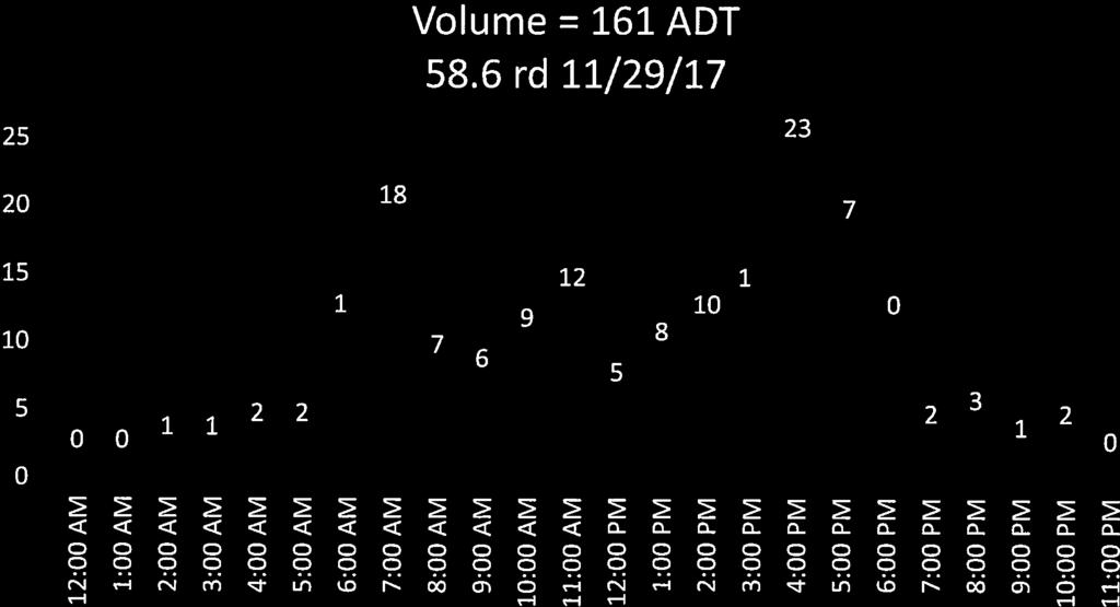
22 TRAFFIC LOADING Flexible (HMA) Design 58.6 Road (Kimball Creek) Project No G Current ADT: 161 vehicles per day Design Life = 20 years Projected ADT: 235 vehicles per day Average ADT: 198 vehicles per day Growth Rate = 1.9% per year Projected ADT = 235 vehicles per day Separate Equivalency Equivalent Anticipated Traffic ADT Factor ADT Combination Trucks: 22% Single Unit Trucks: 5% Cars & Light Trucks: 73% % Total ESAL: 366,814 Lanes per direction: 1 lane(s) Lane Factor: 0.6 Design ESAL: 220,088
23 AASHTO PAVEMENT DESIGN Flexible (HMA) Design 58.6 Road (Kimball Creek) Project No G R-value = 30 S 1 = M r = 6,849 psi W 18 = 220,088 Log(W 18 )= Reliability = 90 % Z R = Deviation, S o = 0.49 p o = 4.2 p t = 2.5 psi = 1.7 Log(W 18 )= Difference = Design SN = 2.86 Full Depth Hot Mix Asphalt (HMA) Structural Drainage Thickness Width Calculated SN Layer Material Coefficient Coefficient (inches) (feet) (inches) HMA Totals Hot Mix Asphalt (HMA) over Aggregate Base Course (ABC) Structural Drainage Thickness Width Calculated SN Layer Material Coefficient Coefficient (inches) (feet) (inches) HMA ABC Totals Hot Mix Asphalt (HMA) over Aggregate Base Course (ABC) over Subbase Structural Drainage Thickness Width Calculated SN Layer Material Coefficient Coefficient (inches) (feet) (inches) HMA ABC Subbase Totals ABC - Aggregate Base Course consisting of CDOT Class 6 (R-value > 78) Subbase - Subbase consisting of CDOT Class 1 or 2 (R-value > 69)


24
25

26

27
28


29


30