Umpqua National Forest
|
|
|
- Angelica Stewart
- 5 years ago
- Views:
Transcription
1 United States Department of Agriculture Forest Service Umpqua National Forest Tiller Ranger District Tiller Trail Highway Tiller, Oregon (541) Fax Dear Interested Citizen, File Code: 1950 Date: January 15, 2014 On July 26, 2013 an unpredicted thunderstorm sparked the Smith Ridge, Buckeye, Big Brother and Whiskey fires, which formed the Whiskey Complex. At the height of activity over 980 personnel were assigned to the complex. All of the fires were declared contained by October 1, 2013 with a final perimeter size of approximately 17,891 acres. All of the fires, except Smith Ridge (23 acres) burned within the Matrix land use allocation under the Northwest Forest Plan. In November of 2013 the Tiller Ranger District hosted several field trips through the burned area to have a discussion on what type of activities could be proposed within the fire area. While opinions ranged widely, there were several activities such as tree planting, removal of roadside hazard trees, fuels treatments and no new road building that were common ground for most people. Utilizing this information the Tiller Ranger District has spent several weeks developing the Whiskey Complex Fire Salvage Project. This project proposes to improve public, forest worker and fire fighter safety, access and road maintenance by: 1) Removing dead and dying trees with a probability of mortality greater than 40% along 8.5 miles of road within the Whiskey Fire and 1/2 mile within the Buckeye Fire. 2) Creating 30.5 miles of shaded fuel break within Matrix lands extending 150 on either side of FS Roads 3114, , 2925, 27, and , by removing trees and shrubs less than 8 in diameter. 3) Conducting maintenance burning in four blocks totaling about 1,300 acres to reduce fuel loading and approximate the fire frequency found within these landscapes. The Project also proposes to recover economic value by: 1) Salvaging all dead trees and dying trees with a probability of mortality greater than 60% and greater than 10 in diameter within a 60 acre plantation adjacent to FS Road ) Salvaging dead trees and dying trees with a probability of mortality greater 60% within a 107 acre natural stand. Approximately 30 % of the area ( 32 acres) will be left as no cut patches centered around legacy trees. Additionally, all large diameter sugar pine and ponderosa pine will be retained unless they occur within skyline corridors. Caring for the Land and Serving People Printed on Recycled Paper
2 This Project proposal does not include tree planting which will be covered under a separate analysis using a Categorical Exclusion. This is being done to allow for implementation of planting existing seedling stock this spring. You can expect a separate scoping letter in the next few weeks describing this project. In addition, this project does not include potential salvage from fire effects to the Beaver timber sales sold in I look forward to your comments on the Whiskey Complex Fire Salvage Project during the scoping period. To be most helpful in aiding us in identifying any issues or alternatives to the proposed action, please submit comments by February 18, 2014 via to commentspacificnorthwest-umpqua-tiller@fs.fed.us or by mail to address shown in the scoping letter. Sincerely, /s/donna L. OWENS DONNA L. OWENS District Ranger

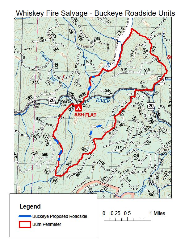
3 Tiller Whiskey Complex Fire Salvage Project The Tiller Ranger District welcomes your comments on the Tiller Whiskey Complex Fire Salvage Project. The Tiller Ranger District on the Umpqua National Forest is proposing activities on Matrix lands and Riparian Reserves within the Whiskey and Buckeye fire perimeters to address road hazards and maintenance, public and forest worker safety, fire fighter access, fuels reduction and recovery of economic value of trees killed as a result of the Whiskey Complex Fire, while also providing for wildlife needs. Background On July 26, 2013, a lightning storm ignited the Smith Ridge, Buckeye, Big Brother and Whiskey fires on the Tiller Ranger District, forming the Whiskey Complex. These fires were fought throughout the summer with Smith Ridge Fire contained on September 7, 2013 at 23 acres, the Buckeye Fire contained on October 1, 2013 at 1,683 acres, and the Whiskey and Big Brother Fires, which grew together, contained on October 1, 2013 at 16,185 acres, for a total of 17,891 acres burned in the complex. The Buckeye and Whiskey/Big Brother fires burned in steep and rugged terrain entirely within Matrix land use allocations (17,868 acres). Landscapes affected by the fire including old growth mixed conifer stands, old growth ponderosa pine stands, young conifer plantations, oak woodlands, meadows, hardwood stands, and riparian areas. Burn intensity ranged from very low to high with mixed degrees of mortality. The areas experiencing highest burn intensity include the northwest flank of Coffin Butte and in Pipestone Creek, both within the Beaver Creek watershed. Figure 1. High intesity burn in a plantation off FS Road What actions are proposed? Proposed activities include felling and removal of roadside hazard trees along 9 miles of road within the Whiskey (8.5 mi.) and Buckeye (0.50 mi.) fires, totaling approximately 305 acres. The project would treat trees that: 1) have been identified as Imminent or Likely according to Field Guide for Danger Tree Identification and Response (R6-NR-FP-PR-01-08) that have a potential failure zone, slide, or roll area that includes a FS road within the project area; or 2) trees identified as having a probability of mortality greater than 40%, following the methodology of Smith & Cluck 2011, having a potential failure zone, slide, or roll area that includes a FS road. Non-merchantable trees that meet above criteria would be felled, piled, and burned or made available for firewood, bio char or other purposes. Where owl cores occur adjacent to a FS road, only trees identified as Imminent or Likely according to Field Guide for Danger Tree Identification and Response (R6-
4 NR-FP-PR-01-08) that have a potential failure zone, slide, or roll area that includes a FS road within the project area would be felled and left as coarse wood. Salvage all dead trees and dying trees with a probability of mortality greater than 60%, following the methodology of Smith & Cluck 2011, and larger than 10 in diameter within a 60 acre plantation adjacent to FS Road Salvage dead trees and dying trees with a probability of mortality greater than 60%, following the methodology of Smith et al. 2011, within a 107 acre natural stand. Approximately 30 % of the area ( 32 acres) would be left as no cut patches centered around legacy trees. Additionally, all large diameter sugar pine and ponderosa pine would be retained unless they occur within skyline corridors. Tree removal would be primarily skyline, some ground-based and helicopter removal. Normal operating season for felling and haul (June-October) would be required for any ground based salvage, while an extended shoulder season, based upon cumulative rainfall and soil moisture, may be utilized for skyline units. Additionally, a winter operating season may be used for helicopter logging. Logging slash found within landings would be made available for firewood or bio char and any remaining material would be burned. After logging operations are complete, reopened roads would be water barred and blocked. Conduct maintenance burning on approximately 1,300 acres, in four blocks, to re-establish an appropriate fire frequency on the landscape, enhance meadows (blocks 1 & 2) improve oakpine habitats (blocks 3 & 4) and reduce large fire potential. Treatments would start in 2018 and would be kept on a 7-10 year interval to approximate anticipated fire frequency. Create and maintain shaded fuel breaks along major/strategic road systems to help aid in future management of fire. These fuel breaks would be 150 on either side of the road (excluding east side of FS 2925 from FS to forest boundary to avoid Late Successional Reserves), and would remove brush and trees less than 8 dbh. Material would be cut/piled and disposed of by burning, firewood or biomass/char opportunities. Maintenance would take place on a 7-10 year interval. These areas would cover approximately 30.5 miles of road system for a total of about 1,010 acres of noncommercial treatment. Fuel breaks include FS Road 3114 from FS 31 to FS 2925, FS 2925 from FS 29 to FS 6620 and FS for the Whiskey fire and FS 27 from FS 28 to FS and FS and 918. Road work for the project would be limited to existing roads and no new roads, system or temporary; would be constructed during the project. Road work would include grading, spot rocking, placement of a 4 6 gravel lift at landings, and other road resurfacing with gravel as needed. This could require the expansion of either the Coffin Butte Quarry (FS junction), or an unnamed quarry (FS /380 junction) to provide rock for the project. Additionally, a 5 deep headcut in the inboard ditch of FS Road 3114 near Beaver Creek would be repaired. The only activities proposed within Riparian Reserves are: 1) danger tree
5 falling adjacent to roads; 2) the falling and removal of smaller dead trees (upstream side only) near culverts to reduce the potential for plugging; and 3) shaded fuel break treatment of trees less than 8 diameter. The project area includes: Whiskey Fire T 30S R 01W Sec , T 30S R 01E Sec , T 31S R 01E Sec. 4-9 R 01W Sec. 1,2,11-13 References Smith, S.L., and D.R. Cluck Marking guidelines for fire-injured trees in California. U.S. Forest Service, Region 5, Forest Health Protection Report RO p. OCUMENTS/stelprdb pdf Buckeye Fire T 29S R 01E Sec. 9-11, 17, 19, 20, 29, & 30 How can you participate? We are seeking your comments on this proposed action for the Whiskey Salvage Project during the scoping period. To be most helpful in aiding us in identifying any issues or alternatives to the proposed action, please submit comments by February 18, 2014 at commentspacificnorthwest-umpquatiller@fs.fed.us. Comments may be submitted in writing to the Tiller District Ranger at the address below: Tiller Ranger District District Ranger Tiller-Trail Highway Tiller, OR Attention: Whiskey Complex Project Manager Who should you contact for technical information on this project? Calib Baldwin, Project Manager ctbaldwin@fs.fed.us Phone (541)

6
7

8