Prospectus for the Lower Saline River Mitigation Bank Cleveland County, Arkansas. Arkansas State Highway and Transportation Department
|
|
|
- Joshua Wheeler
- 5 years ago
- Views:
Transcription
1 Prospectus for the Lower Saline River Mitigation Bank Cleveland County, Arkansas Arkansas State Highway and Transportation Department June 2012
2 The Arkansas State Highway and Transportation Department (AHTD) proposes the establishment of a wetland and stream mitigation bank in Cleveland County, Arkansas. The Lower Saline River Mitigation Bank (LSRMB) is located on the south side of the Saline River about five miles south of Rison on the west side of Highway 79 just 4.6 miles north of Kingsland (Figure 1). The 240-acre site is in section 28 Township 9S, Range 11W (Figure 2). The property would be used for compensatory mitigation for unavoidable impacts resulting from AHTD highway activities authorized under Section 404 of the Clean Water Act. A. Management Goal and Objectives: The management goal for the mitigation site is the restoration/rehabilitation of the historic bottomland hardwood ecosystem. Objectives include the reforestation, hydrology enhancement, and protection of wetlands and associated uplands on the 240-acre site. Hydrology will be enhanced by removing temporary crossings that were placed within the existing stream channels for access during timber harvest. B. Establishment and Operation: An interagency Review Team (IRT) would facilitate the establishment of the site. The IRT would allow review and seek consensus from Federal, state and public entities on Mitigation Banking Instrument (MBI). The Little Rock District US Army Corps of Engineers Little Rock District (SWL) and Vicksburg District (MVK) would serve as Chair of the IRT and will make final decisions regarding the terms and conditions of the MBI. AHTD would be the sponsor of the site and owner of the mitigation property and would be responsible for all mitigation and monitoring actions. Agencies invited to participate on the IRT include the U.S. Environmental Protection Agency, Region VI (EPA); the U.S. Fish and Wildlife Service, Region IV (FWS); the Federal Highway Administration, Arkansas Division (FHWA); the Natural Resources Conservation Service (NRCS), the Arkansas Department of Environmental Quality (ADEQ); the Arkansas Game and Fish Commission (AGFC); the Arkansas Natural Heritage Commission (ANHC); and the Arkansas Natural Resources Commission (ANRC). C. Proposed Service Area: The site is located within the United States Geological Survey (USGS) Hydrologic Cataloging Unit , which includes portions of Jefferson, Lincoln, Drew, Ashley, Bradley and Cleveland Counties. Hydrologic Cataloging Unit (HUC) will serve as the LSRMB s primary service area. The Lower Saline Watershed includes Hudgin Creek, Big Creek, Saline River and L Aigle Creek. Adjacent water sheds include Bayou Bartholomew Watershed (HUC ) and the Lower Ouachita-Smackover Watershed (HUC ) (Figure 4). The LSRMB will be used to compensate for unavoidable stream and wetland impacts occurring within the primary and surrounding watersheds. D. General Need and Feasibility: AHTD is required to mitigate unavoidable losses to wetlands and streams due to highway construction projects in the proposed service areas.
3 E. Ownership: AHTD will be the owner of the property and will record a restriction on the Warranty Deed to the property. The restriction requires that any activity to the property complies with the terms of a mitigation plan or banking instrument. AHTD will manage the property for the operational life of the bank. The operational life of the bank terminates when compensatory mitigation credits have been exhausted and the bank is self-sustaining. Subsequently, AHTD may deed the property to or enter into a management agreement with an appropriate state or Federal agency provided the agency manages the property in accordance with the provisions of the MBI. F. Long-term management: AHTD is responsible for securing adequate funding to monitor and maintain the mitigation area throughout its operational life, as well as beyond the operational life if not self-sustaining. AHTD would be responsible for securing sufficient funds to cover contingency actions in the event of bank default or failure. Additionally, AHTD would be responsible for providing alternative compensatory mitigation if it is determined necessary by the Corps. G. Qualifications of the Sponsor: AHTD is presently the owner and sponsor of five mitigation banks, totaling 1,950 acres of wetland mitigation property managed according to approved banking instruments. H. Ecological Suitability: The primary considerations for site selection were watershed needs, baseline conditions, and habitat connectivity. The project area is located the South Central Plains Ecoregion bordering the Saline River. Much of the surrounding property is owned by timber management companies. Soils on the site are mapped (Figure 5) in two soils units by the USDA, Ochlockonee-Wehadkee association and Wehadkee-Caddo association. The Ochlockonee-Wehadkee association occurs near the Saline River. It is about 65 percent Ochlockonee soils, 25 percent Wehadkee soils, and 10 perent Collins and Falaya soils. The soils of this association are poorly drained to well drained. They are subject to frequent flooding. The topography is undulating. Slopes rarely exceed 3 percent. The Wehadkee-Caddo association also occurs near the Saline River. It is about 65 percent Wehadkee soils, 30 percent Caddo soils, and 5 percent Collins, Falaya, and Ochlockonee soils. The soils of this association are frequently flooded and are poorly drained or somewhat poorly drained. The Caddo soil is not flooded so frequently as the Wehadkee soil, or for as long a time. Vegetation on the proposed site consisted of overcup oak (Quercus lyrata), cherrybark oak (Q. pagoda), water oak (Q. nigra), willow oak (Q. phellos), sweet gum (Liquidambar styraciflua), sugarberry (Celtis laevigata), sycamore (Platanus occidentalis), green ash (Fraxinus pennsylvanica), cypress (Taxodium distichum), blackberry (Rubus sp.), broom sedge (Andropogon virgincus), fleabane (Erigeron philadelphicus), knotweed (Polygonium sp.) and witch grass (Panicum capillare).
4 The entire site is subject to frequent flooding from the Saline River. The landform is very level, averaging about a 0.1% slope. The site had been in timber management, until the landowner removed most of the remaining timber from the entire site. The Saline River, which serves as the northern boundary of the property, has been designated as an Ecologically Sensitive Waterbody, an Extraordinary Resource Waterbody, and a Natural and Scenic Water. Several threatened and endangered species of mussels can be found within the river, including the pink mucket (Lampsilis abrupta) which has been found in the stretch of the river bordering this property. Numerous other species of greatest conservation need have also been recorded from the area, including the western fanshell (Cyprogenia aberti), the monkeyface (Quadrula metanevra), the pyramid pigtoe (Pleurobema rubrum), the black sandshell (Ligumia recta), and the crystal darter (Crystallaria asprella). The property also lies approximately 3 miles due north of the Arkansas Natural Heritage Commission s Kingsland Prairie Natural Area. Kingland Prairie is home to a number of rare plant species including Geocarpon minimum, a federally listed threatened species.
5 Rison Kingsland 79 Dallas County Cleveland County Project Location! Mile Figure 1 Proposed Lower Saline River Mitigation Area Project Location AHTD - Environmental GIS - Reed February 16, 2012


6 79! AHTD Feet - Environmental GIS - Reed February 16, 2012 Figure 2 Topographic Map Mitigation Area Fordyce NE 1985 and Rison 1982 USGS Topographic Maps


 Wetland (46.")


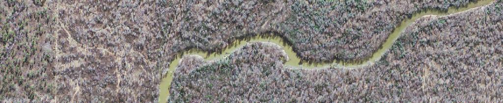
7 Saline River Feet AHTD - Environmental GIS - Reed March 28, 2012 Figure 3 Stream and Wetland Location Map Stream (12,385.4 feet) Wetland (46.1 acres) Channel Scar Wetland (35.7 acres) Mitigation Area (241.3 acres) Photography Date: Summer 2010


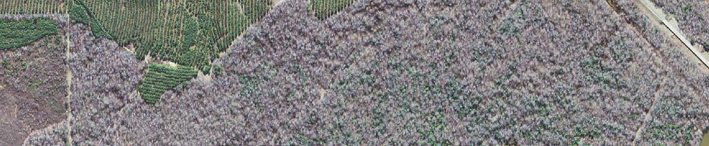
8 Saline River Feet AHTD - Environmental GIS - Reed February 21, 2012 Figure 4 Soil Map Mitigation Area Wehadkee-Caddo Ochlockonee-Wehadkee Photography Date: Summer 2010
9 Lower Ouachita Smackover ( ) Bayou Bartholomew ( ) Lower Saline ( )! AHTD Miles - Environmental GIS - Reed February 21, 2012 Figure 5 Proposed Service Area Watersheds Proposed Mitigation Area Primary Service Area Secondary Service Area


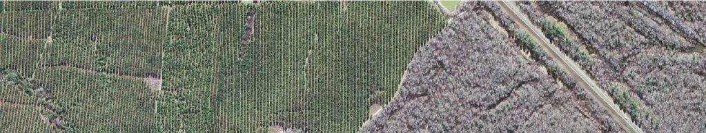
10 Saline River 79! AHTD Feet - Environmental GIS - Reed February 21, 2012 Figure 6 Site Location Map Mitigation Area Photography Date: March 2006


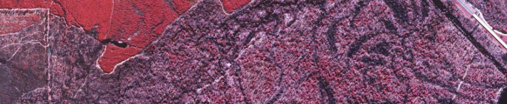

11 Saline River 79! AHTD Feet - Environmental GIS - Reed February 21, 2012 Figure 7 Historic Aerial Mitigation Area Photography Date: March 25, 2001


12 Photo 1. Typical view of the proposed site looking toward the northwest, 29 February Photo 2. Typical view of proposed site looking toward the north, 29 February 2012.

13 Photo 3. Typical view of proposed site looking east, 29 February Photo 4. Typical view of the wetlands after timber was harvested, 29 February 2012.


14 Photo 5. Typical view of wetlands after timber was harvested, 29 February Photo 6. One of many channels on the site without buffers, 29 February 2012.

15 Photo 7. Temporary crossing left in place by timber company, 29 February 2012.