Technical Session - Planning and Forest Management. 1. Planning for Natural Resource Management 2. Forest Inventory 3.
|
|
|
- Owen Robertson
- 5 years ago
- Views:
Transcription
1 Technical Session - Planning and Forest Management 1. Planning for Natural Resource Management 2. Forest Inventory 3. Forest Management
2 Planning for Natural Resource Management Nancy Young, Forester USAID/USDA Natural Resources Conservation Service Material translated by: Mohammadullah Karimi, Training & Liaison Officer Afghan Conservation Corps
3 Objectives of Course Participants will understand the concepts of natural resource planning. Participants will understand the steps of resource planning. Participants will be able to draft a planning document for solving resource concerns.
4 Concepts of Natural Resource Planning

5 What is Natural Resource Planning? Planning is a natural resource problem solving and management process. It integrates economic, social, and ecological considerations to meet the needs of both the local people and the government.

6 Natural Resource Planning The process provides the framework for developing sound natural resource plans that meet all the ecological, economic, social, and policy considerations for which we have to plan.

7 Natural Resource Planning The objective of the planning process is to help achieve good use and management of soil, water, air, plant, and animal resources to prevent their degradation and to assure their sustained use and productivity while meeting the needs of the people.
8 Natural Resource Planning The process can be used regardless of the expected outcome, scope, size of the planning area, complexity of natural resource problems, or source of funding to be used to implement the plan.

9 Planning Considerations Planning levels can include: Afghanistan District Province Watershed Village area
10 Planning Considerations For all these levels within a plan, consider: 1. Consequences of proposed actions 2. Cumulative effects of proposed actions 3. Needs of each level
11 Planning Considerations To plan well, we must recognize the connections between the planning unit, larger areas outside or around the planning unit, and smaller areas within the planning unit.
12 Planning Considerations Think of the planning area beyond its administrative, jurisdictional, and geographic boundaries.
13 Planning Considerations Consider the short-term and long-term effects of actions.

14 Planning Considerations Consider human economic needs and goals.


15 Planning Considerations Facilitate the creation of a desired future condition that meets individual and societal needs.


16 Planning Considerations Recognize that human welfare depends on the sustainability of natural resources.
17 Planning Considerations Base plans on the best current knowledge, science, and technology. Incorporate the knowledge gained from previous planning, implementation, and evaluation efforts. Utilize the resources and expertise of others.


18 Planning Considerations Cooperate with others in collecting, assembling, and evaluating data.
19 Planning Considerations Identify, prevent, and mitigate to the greatest extent practicable adverse human health or environmental effects of planning on affected populations.
20 Before Planning Begins Pre-planning is crucial in efficiently completing Phase I of the planning process. In each phase, pre-planning can make plan completion easier by having all the necessary tools and procedures before beginning to plan.


21 Before Planning Begins Maps Tools Worksheets Knowledge


22 Before Planning Begins
23
24

25
26 Natural Resource Planning The planning process consists of 9 steps divided into 3 phases. It considers people and the resources they use or manage and is based on desired future conditions.
27 Phase 1: The Planning Process Understanding the Problems and Opportunities Phase 2: Understanding the Solutions Phase 3: Understanding the Results
28 Phase 1: Information Collection and Analysis 1. Identify Problems and Opportunities 2. Determine Objectives 3. Inventory Resources 4. Analyze Resource Data
29 Identify Problems Inventory Resources Analyze Resource Data Phase 1: Collection and Analysis Determine Objectives Formulate Alternatives Make Decisions Evaluate Alternatives Inventory Resources Phase 2: Decision Support Determine Objectives Phase 3: Application and Evaluation
30 Phase 2: Decision Support 5. Formulate Alternatives 6. Evaluate Alternatives 7. Make Decisions
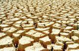
31 Identify Problems Inventory Resources Analyze Resource Data Phase 1: Collection and Analysis Determine Objectives Formulate Alternatives Make Decisions Evaluate Alternatives Inventory Resources Phase 2: Decision Support Determine Objectives Phase 3: Application and Evaluation
32 Phase 3: Application and Evaluation 8. Implement the Plan 9. Evaluate the Plan and Report Results.
33 Identify Problems Inventory Resources Analyze Resource Data Phase 1: Collection and Analysis Determine Objectives Formulate Alternatives Make Decisions Evaluate Alternatives Inventory Resources Phase 2: Decision Support Determine Objectives Phase 3: Application and Evaluation
34 The Nine Steps of Natural Resource Planning: 1. Identify Problems and Opportunities
35 Identify Problems and Opportunities What does the area look like now? What do you want it to be like? What stands in your way of getting it to be like you want it to be?
36 What is a Natural Resource Problem? A natural resource problem is a condition that does not meet your needs for that resource. It can be degraded woodlands, overgrazed areas, soil erosion, or other problems.
37 Why do We Need to Look at all the Problems? Natural resources are all connected. If we try to fix one problem, we may unknowingly make another problem worse. We must understand all the problems before we begin planning.
38 Common Resource Problems Soil Quality Sheet/rill erosion Gully erosion Wind erosion Deposition Streambank/shoreline erosion Compaction Organic matter

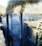
39 Soil Erosion
40 Common Resource Problems Surface Water Quality Sedimentation Animal wastes Loss of vegetation Loss of wetlands Nutrients or pesticides Temperature extremes

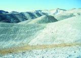
41 Degraded Water Quality
42 Common Resource Problems Ground Water Quality Animal wastes Nutrients and chemicals Salts

43 Ground Water Quality
44 Common Resource Problems Water quantity Insufficient supply for irrigation, livestock, community use Declining water tables

45 Dried Water Bodies
46 Common Resource Problems Air quality Smoke or other particulates Excessive wind erosion Smells

47 Degraded Air Quality
48 Common Resource Problems Plants Deforestation Loss of riparian vegetation Weed invasion Loss of plant diversity Threatened or endangered species Pest infestation

49 Degraded Woodlands
50 Common Resource Problems Animals Inadequate water Loss of forest, grass cover, or riparian vegetation Poor grazing management Threatened or endangered species Health issues
51 Overgrazing

52 Common Resource Problems Human Monetary Training Labor

53 Human Traditional Values
54 Tell about the Problems Describe each problem or opportunity in terms of location and severity: How much land is affected How bad the problem is What kind of damage Limited desired activities because of impaired resources
55 Tell About the Problems Quantify damage in terms of losses (both monetary and non-monetary) Make maps showing damage locations or where damage may be prevented How often damage occurs
56 Tell About the Problem Social, cultural, and ecological impacts that are occurring because of a problem Opportunities for improving human quality of life
57 The Nine Steps of Natural Resource Planning: 2. Determine Objectives
58 Resource Inventory 1. Establish the types of inventories you need and the degree of detail needed in each inventory. Decide what will be done and estimate how much time and funds will be required to carry out the inventory activities.
59 Resource Inventory 2. Develop and distribute an inventory action plan to all persons or organizations responsible for items in the action plan. Make copies available for other interested parties.
60 Resource Inventory 3. Collect available information: completed inventories by other parties, maps, reference materials, talks with local people, etc.
61 Resource Inventory 4. Keep everyone informed of progress of the inventories.
62 Resource Inventory 5. Use natural resources as teaching aids while in the field with the land-users. This provides them an opportunity to learn conservation principles.
63 Resource Inventory 6. Conduct the required resource inventories to describe the current conditions, crops, soils, major resource problems etc. (the benchmark condition).
64 Resource Inventory To inventory resources, you will need the following items: 1. Personnel with proper training 2. Equipment such as vehicles, tools, etc. 3. Maps and photos 4. Inventory procedures 5. Information from other sources
65 The Nine Steps of Natural Resource Planning: 4. Analyze Resource Data
66 Analyze Resource Data We must now study all the information that we got from the inventories, talking to the people, and other sources. We will define the natural resource conditions, including limitations to their use and potentials. This step provides the information needed to formulate and evaluate alternatives.
67 Why Must We Analyze Resource Data? Having lots of information about an area does not do us any good unless we can understand what it means. Analyzing the data lets us understand the meaning of the information so that we can make useful decisions.

68 Analyze Resource Data The analysis should clearly show the cause and effect relationships between the problems and the resources, and it will provide information about existing and future conditions of the land.
69 Analyze Resource Data Products of this planning step: A complete analysis of all resources inventoried A clear statement of the benchmark condition of the planning area Identification of the causes or conditions of the resource problems
70 Analyze Resource Data A complete definition of problems, opportunities, and concerns A complete statement of objectives Quality criteria for the resources involved
71 The Nine Steps of Natural Resource Planning: 5. Develop Management Alternatives
72 Develop Management Alternatives This planning step begins Phase II of the planning process. Revisit earlier steps if new objectives or concerns are identified during this phase.
73 Why do We Develop Management Alternatives? The purpose of developing alternative solutions to our problems is to provide the most effective, efficient, and economical conservation treatments that meet our quality criteria and are acceptable in solving problems, addressing opportunities, and meeting objectives.
74 Develop Management Alternatives We will develop alternatives that will: Achieve objectives Solve identified problems Take advantage of opportunities Prevent additional problems from occurring
75 Develop Management Alternatives Develop enough alternatives to provide the opportunity to consider several possibilities. Example of Alternatives Alternative 1: Build Check Dams Only Alternative 2: Plant trees, Control Overgrazing Alternative 3: Build Check Dams, Plant Trees Alternative 4: Do Nothing
76 Develop Management Alternatives If incorrect or insufficient data has been assembled for proposing alternatives, then return to planning steps 3 and 4 before proceeding.
77 Develop Management Alternatives If it is noted that the problem is not clearly identified or defined, return to planning step 4 and review these concerns.
78 Develop Management Alternatives The product of this planning step will be a description of the alternatives available.
79 Develop Management Alternatives 1. Identify conservation systems and other treatments that will address the objectives from planning step 2 and the problems and opportunities from planning step 1. Consider both land treatment (non-structural and structural) and preventative measures.
80 Develop Management Alternatives 2. Develop alternative plans: Group complementary measures that have a positive effect on the resources into alternatives. Each alternative should provide results that meet quality criteria.
81 Develop Management Alternatives b. Describe the future conditions if no accelerated action is taken to solve the problems.
82 Develop Management Alternatives c. Select the potential practices and systems available to meet specific needs.
83 Develop Management Alternatives d. The complexity of resource issues or specific responsibility for certain resource issues may require that other agencies provide technical assistance.
84 Develop Management Alternatives e. Compare the expected effects of each alternative to the quality criteria. Where the predicted result from the alternative does not meet quality criteria, change the alternative or drop it from consideration.
85 Develop Management Alternatives 3. Estimate the costs and effects of each alternative: a. Develop designs and cost estimates. b. Complete an initial estimate of ecological, social, and economic effects.
86 Develop Management Alternatives c. Check to determine that the alternative is complete (contains all components, including operation and maintenance) to assure that it will function as planned and will produce the desired effects.
87 Develop Management Alternatives d. Include measures needed to mitigate any potential ecological damages. e. Avoid alternatives that cause other ecological damages.
88 Develop Management Alternatives f. Evaluate the risk and uncertainty associated with each alternative.
89 Develop Management Alternatives 4. Record the alternatives.
90 The Nine Steps of Natural Resource Planning: 6. Evaluate Alternatives
91 Evaluate Alternatives Evaluate the alternatives to determine their effectiveness in addressing the problems, opportunities and objectives.
92 Why do We Evaluate Alternatives? The purpose of evaluating alternatives is to provide the information needed to make sound decisions. We compare each alternative solution to the problems so that we can later choose the best one.
93 Evaluate Alternatives During the evaluation of alternatives, careful consideration must be given to social, economic, and ecological resource factors that influence planning. The planner may discover a need to revisit any or all of the previous steps during discussions with the client or during any part of the evaluation.
94 Evaluate Alternatives Products A set of practical, affordable alternatives that are compatible with both government and local objectives A record of public participation for project planning An evaluation, for each alternative, displaying the effects and impacts to consider and use as a basis for decision making for the plan
95 Evaluate Alternatives For each alternative: 1. Quantify the effects on the physical resources, where possible, both for the benchmark and each alternative.
96 Evaluate Alternatives 2. Quantify effects of each alternative on social and economic considerations. Describe, in qualitative terms, effects that cannot be quantified.
97 Evaluate Alternatives 3. Convert effects to monetary terms. Consider the trade-offs between shortterm profit needs and long-term sustainability.
98 Evaluate Alternatives 4. Determine the beneficial and adverse impacts of each alternative.
99 Evaluate Alternatives 5. Display the evaluations in a manner easily understood by the decision makers who will choose which alternative to implement.
100 Evaluate Alternatives The same format should be used for the benchmark and all alternatives, and should contain the following: A description of the resource setting, A description of the management system,
101 Evaluate Alternatives A complete list of the kind, amount, and timing of actions involved in the management system that may change as a result of the plan, Effects of the actions on the resources and human considerations
102 Evaluate Alternatives Impacts of each alternative in comparison to the benchmark.
103 The Nine Steps of Natural Resource Planning: 7. Make Decisions
104 Make Decisions The planner now compares the conservation treatment alternatives and chooses the one that is the best for the resources and the people. Alternative A or Alternative B or Alternative C?
105 Make Decisions A resource management system is selected based on a clear understanding of the impacts of each alternative. The selected alternative is recorded in the project plan. Alternative B
106 Make Decisions Products: The plan document with the selected alternative, including implementation opportunities and operation and maintenance. Schedule of conservation system and practice implementation.
107 The Nine Steps of Natural Resource Planning: 8. Implement Plan
108 Implement Plan Implementing a plan is the process of carrying out the conservation treatments that have been chosen. Well documented and understood decisions are a necessary to apply the plan.
109 Implement Plan This step in the planning process is where we get the work done that we want to do. Implementation includes the design, layout, construction, inspection, management, operation, and maintenance of planned systems and practices.
110 Implement Plan Products Conservation practices applied Communication with the stakeholders
111 The Nine Steps of Natural Resource Planning: 9. Evaluate the Results
112 Evaluate the Results Conservation planning is an ongoing process that continues after the plan has been implemented. This step begins the third phase of the planning process.
113 Why do We Evaluate the Results? Evaluate the effectiveness of the implemented plan to be sure that it is functioning as planned and achieving the objectives; to identify reasons for lack of progress in plan implementation, if needed; and to obtain information on the results of the applied treatment.
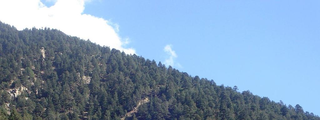
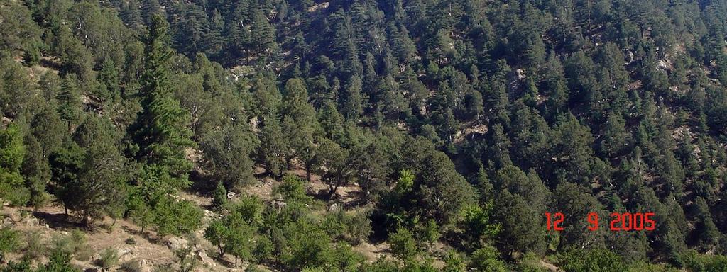
114 Evaluate the Results Observe the performance of each applied conservation practice to determine if the practices and management systems are solving the identified problems and meeting ecological, economic, and social objectives.

115 Evaluate the Results Where the actual results differ from those anticipated, provide information into the planning process.
116 Evaluate the Results Every planning area serves as a potential laboratory to help in the continuous process of improving alternative treatments for natural resource problems and concerns, and to take advantage of opportunities.
117 Evaluate the Results The process of monitoring, evaluating, and experimenting in order to add to resource management information and modify decisions is known as adaptive management.
118 Evaluate the Results Products Outline of maintenance needs or other changes A decision to update or revise the plan, if needed Case studies, if appropriate Recommendations for changes in practice, installation methods, specifications, or designs A decision to revise or expand implementation strategies
119 Forest Inventory Nancy Young, Forester USAID/USDA Natural Resources Conservation Service And Mohammad Ismail Nasri, Senior Technical Officer/Forester Afghan Conservation Corps
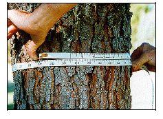
120 Objectives of Course Students will understand the concepts of forest inventory. Students will understand the use of common forest inventory tools.
121 What is Forest Inventory? Forest Inventory is a systematic approach to finding out about all the forest resources in a forest stand. It helps you to discover how large the forest is, what kinds of trees grow there, how many trees per hectare, what the soil is like, what wildlife species use the forest, and many other things that you need to know.
122 Why do Forest Inventory? You must know all available information about a forest before you can manage the forest in a knowledgeable way. You cannot teach the local people about the forest if you do not fully understand all the parts of it.
123
124 What do We Inventory? Tree Species Tree Diameter Tree Height Timber Volume Slope of the land Soil Depth Soil ph Other information as needed
125 Tools for Forest Inventory
126 How do We Measure the Forest? There are many tools that we can use to measure distances, size of the trees, and other things that we need to know.
127 Logging Tape A logging tape is used to measure distances during the inventory process. The two sides of the tape show different scales. One side has a distance measurement in meters, and the other side has a tree diameter scale in centimeters. You must be careful to use the proper side of the tape for each kind of measurement.
128
129 Logging Tape You can measure up to 30.5 meters in distance with the tape and up to 500 centimeters in tree diameter.
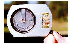
130 Logging Tape To measure distance, have someone hold the end of the tape and walk away until the desired distance is measured. If you are working alone, you can fasten a nail around the metal end of the tape so that you can push it into a tree or other object to hold the end of the tape in place while you walk. The tape can be fastened to a belt to make the measuring easier. Then when you have measured the distance, simply pull the tape gently until the nail comes loose, and the tape will retract into the holder. Be careful not to let it hit you as it retracts.
131 Diameter Tape The diameter side of the logging tape is used to measure the diameter of a tree trunk at 1.37 meters from the ground. It is very easy to use and is also very accurate.
132 Diameter Tape To use the diameter tape, wrap it around the tree trunk at the proper height and read the scale where the tape overlaps. You must wrap the tape evenly around the tree do not allow one side of the tape to drop below the other side.
133
134 Diameter Tape If you are working on slopes, always stand on the upslope side of the tree to measure it. Stand on this Side of tree
135 Diameter Tape If the tree is forked (grown into 2 trunks), measure the diameter of each fork above the place where it forks. Measure Here
136 Diameter Tape You will need to oil the tape periodically to clean it and keep it from rusting. Just apply a light oil (not motor oil) onto the tape with a cloth and then wipe clean with another cloth. This is especially necessary if you have used the tape in the rain or snow.
137 Clinometer A clinometer can be used to measure tree height. It can also be used to measure slopes when conducting soil and water conservation evaluations, so it is a multipurpose tool. It is more difficult to learn to use, but it is a very accurate tool once you have learned.
138 Clinometer
139 Clinometer To use the clinometer, hold it to your eye with both eyes open. Look through the lens and along the outside of the instrument at the same time. Raise or lower the clinometer (by tilting your head) to place the sighting line at the top or base of each tree.


140 Clinometer
141 Clinometer To measure tree height, stand at the baseline distance of 30.5 meters from the tree, sight the top of the tree and read the scale; sight the base of the tree and read the scale.
142 Clinometer
143 Clinometer To compute tree height, add the 2 scale readings if you looked up to the top of the tree and down to the base, or subtract the height to the base of the tree from the height to top if you had to look up to both the top and the base of the tree. Divide this number by to get the height of the tree in meters.
144 Clinometer +100% +148% -26% 30.5 m Tree Height /3.2808=38.4m +26% 30.5 m Tree Height /3.2808=37.2m
145 Clinometer It is much easier to measure height of trees on slopes if you stand on the same slope contour as the tree. Sometimes this is not possible because you cannot find a place on the same contour where you can see both the bottom and the top of the tree.
146 Clinometer You will need to clean the clinometer sometimes to remove the dust. You may just wipe it with a soft, clean cloth to do this. Do not open the clinometer housing.
147 Compass A compass is used in the inventory process to lay out the lines of measurements to be made. It is a useful tool to help prevent getting lost in the forest as well.
148
149 Compass Orienting Arrow Compass Needle Direction of travel arrow Orienting lines Compass housing
150 Compass When using the compass, you must be careful to hold it level in front of you so that the compass needle can swing freely. The red end of the needle will point north.
151 Compass A bearing is a measurement of travel direction between two points. It is expressed as the degrees of the angle of the travel direction. You must orient the compass to the bearing that you will travel. You do this by turning the compass housing to the bearing of the direction you want to go.
152 Compass After taking the bearing, hold the compass level and in front of you, so that the direction of travel arrow points to the destination.
153 Compass Rotate your whole body until the magnetic needle lies directly over the orienting arrow. Make sure the north end of the magnetic needle points to N on the compass housing. The direction of travel arrow points to the destination.
154 Compass Sight a prominent feature like a tree or a rock to which your direction of travel arrow points. Walk to that feature. Continue to sight on other features along the bearing and walk to them, until you reach your destination.
155 Compass The north-seeking arrow on your compass points to north, but it can also point to local magnetic disturbances. Your metal clipboard might be one, as might your rifle, vehicle, wristwatch, sunglass frames, radio, or knife. Be careful not to hold your compass over metal objects. Iron ore deposits can also be a natural source of magnetism which will disturb the compass.
156 Compass Be careful not to drop the compass because the mirror or the liquid-filled dial will break. The compass may be cleaned by wiping it with a clean, soft cloth. Take care not to drop the compass as this can damage it.
157 Inventory Methods
158 Samples We cannot count and measure every tree in the forest. It would take much too long. But we can count and measure enough of them to give us a sample of what the average conditions in the forest are like.
159 Samples There are several ways of taking samples of the forest: 1. Systematic Method 2. Randomized Method 3. Selection Method
160 Samples The systematic method involves setting up a grid line with plots to be taken at regular intervals where the grids cross. The randomized method is used to take a smaller but unbiased sample of the plots from the grid line. The selection method takes some of the samples from the grids in a biased manner.
161 Strip Sampling In strip sampling, the sample units are continuous strips of uniform width spaced at a predetermined distance apart. The width of the strips and the distance between the centerline of the strips determines the percentage of the area sampled.
162 Strip Sampling
163 Strip Sampling
164 Plot Sampling In fixed plot sampling, a set of plots (all the same size) is located throughout the area. The sample plots can be located throughout the area in a number of ways. The most common method is to locate the plots at predetermined intervals on lines a set distance apart. Plots can be any shape but circular plots are most commonly used. The size and number of plots determine the percentage of the area sampled.
165 Plot Sampling
166 Plot Sampling m
167 Forest Management Nancy L. Young, Forester USAID/USDA Natural Resources Conservation Service Material translated by: Mohammadullah Karimi, Training & Liaison Officer Afghan Conservation Corps
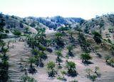
168 Managing Forests Managing established forests is a complicated matter. You must control how much wood is cut from the forest at the same time that you take care of the people s needs for wood.
169 Managing Forests Managing forests involves much more than just cutting wood, however. Forest management uses many types of conservation practices including taking care of mature forests as well as site preparation, tree planting, irrigation, soil erosion practices, forest protection, grazing practices, harvest road construction, and protected areas.
170 Managing Existing Forests
171 Managing Existing Forests The first thing that you should do to manage an existing forest is to complete a forest inventory. As we have already discussed, the inventory is needed to know important information about the forest. You cannot properly manage the forest without it.
172 Managing Existing Forests Once you know about the forest from the inventory, you should divide the forest into compartments, or parcels. The compartments are divided so that areas that have the same forest characteristics are managed in the same way.
173 Managing Existing Forests The compartments might be divided by type of trees, size of trees, erosion areas, grazing areas, plantations, and other considerations. The key idea is to put the areas that can be managed the same way into the same compartments.
174
175 Village Forest
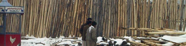
176 Conserved Area Medium Hardwoods Eroded Area Village Large Pines Poplars New Plantation
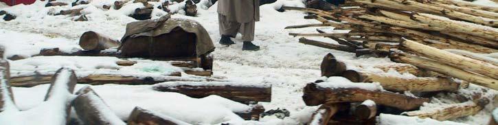
177 Conserved Area Medium Hardwoods Eroded Area Village Large Pines Poplars New Plantation The New Plantation will be protected from grazing, human damage, and fire. Irrigation is needed.
178 Conserved Area Medium Hardwoods Eroded Area Village Large Pines New Plantation Poplars The poplars will be selectively thinned for roof poles as needed by the village.
179 Conserved Area Medium Hardwoods Eroded Area Village Large Pines New Plantation Poplars The large pines will be thinned periodically to remove accrued growth. Harvesting will be done by selection of trees to remove.
180 Conserved Area Medium Hardwoods Eroded Area Village Large Pines New Plantation Poplars Check dams for soil erosion will be built here as needed. The site will be terraced and planted with pines. Protection and irrigation will be provided.
181 Conserved Area Medium Hardwoods Eroded Area Village Large Pines New Plantation Poplars The medium hardwoods will be managed for timber and firewood. Trees will be individually chosen for cutting.
182 Conserved Area Medium Hardwoods Eroded Area Village Large Pines New Plantation Poplars The conservation area will be maintained as a wind break and wildlife habitat. Only fallen or dead trees will be used from this area.
183 Forest Harvests
184 Forest Harvests Cutting the trees in the forest is necessary from time to time to maintain the health and vigor of the forest and to provide needed timber products from the forest. You should conduct the harvests in a sustainable manner so that the forest is not degraded by what you do.
185 Why Do We Harvest? Cutting in merchantable forest stands is done periodically to concentrate growth on crop trees, reduce susceptibility to diseases and insects, remove suppressed and dying trees, improve growth of grasses and other plants beneficial for livestock and/or wildlife forage, adjust species composition, and increase economic gain for the land users.
186 Forest Harvests Rules to follow for harvesting trees: Don t remove more tree volume than what will grow back before the next harvest. In stands that are not fully stocked, only a portion of the growth is cut. Always leave your very best trees in the forest for the future.
187 Forest Harvests Trees to be cut from the forest should be selectively chosen. The worst trees in the forest should be cut first: 1. Diseased or unhealthy trees 2. Damaged trees 3. Forked trees 4. Trees with suppressed growth from being in the shade of other trees 5. Old trees that might die before the next harvest.
188 Forest Harvests Harvest tree selection will be done either by targeting single individual trees or by removing a group of trees to create openings in the forest canopy. The openings provide freedom from competition for the natural establishment of tree species that are intolerant of shade, such as pines and oaks. In this manner a diversity of age and size classes of trees is maintained.
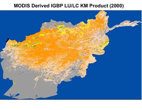
189 Forest Harvests It is important to time harvest treatments and proceed with practice installation carefully to avoid damage to the site. It may be years before a forest recovers from improper harvesting practices. Locating a harvest road in the wrong spot can lead to severe soil erosion. Running heavy trucks over wet roads can damage the soil.
190 Harvest Roads Harvest roads should generally follow natural contours and slopes to minimize disturbance of drainage patterns. They should be located where they can be maintained and where water management problems are not created.
191 Harvest Road Design 1. The minimum width of a logging road should be 4.5 meters. The road should be a little wider around curves and turnouts. 2. Turnouts are needed on single lane roads where traffic will be going in both directions. The width will be increased to a minimum of 6.25 meters for a distance of at least 9 meters. This will allow vehicles to pass safely.
192 Harvest Road Design 3. Provide turn arounds at the end of dead end roads. 4. Water management on the road is extremely important to prevent soil erosion. Provide culverts or water bars to move water from one side of the road to the other. Spacing of the water management structures depends upon the grade of the road and the type of soil.
193 137 Recommended Spacing for Relief Culverts and Water Bars S p a c i n g m Sands, Silts, & Clay Soils Gravelly Soils Road Grade %
194 Harvest Road Design 5. Turnout ditches can be used to move the water away from the road and to disperse it into vegetated areas or piles of rocks. 6. Surface crowning can also be used to direct road runoff into side drainage ditches. 7. Roadside ditches should be 0.3 m below the road surface to provide internal drainage. 8. Drainages should be crossed at 90 degree angles. Road Gradient (% Slope) >10 Spacing of turnout ditches 61 meters 30.5 meters 23 meters
195 Plantations
196 Plantations Because so many of the forests of Afghanistan have been degraded or destroyed, you will have to plan tree planting projects to try to get the forests back. These plantations will require a lot of work in the form of site preparation, planting, irrigation, and protection.
197 Site Preparation Terraces Build the planting terraces on the contour of the land. Improperly designed terraces will cause soil erosion problems. On steeper slopes, make the terraces 3 meters apart. On gentler slopes, make the terraces 4 meters apart.
198 Site Preparation Pits Dig a planting hole 3 times the width of the tree s root ball. The depth of the pit should be the same depth as the root ball or a little less. Do not dig deeper than the depth required to have the first roots just below ground level.
199 Planting Saplings Use healthy trees with no more than 2 times as much top as roots. The root system should be well developed with many root branches. The roots should not be wrapped around and around inside the planting bag. The tree stems should have no wounding, disease, or decay. 2X 1X
200 Planting Seeds Use seeds from local trees if possible. Choose the best trees from which to gather the seeds. Consider good growth, good form, resistance to disease, and other factors when choosing. Cover the seed so that their depth is 2-4 times their size.
201 Irrigation The young trees should be watered for several years if possible. The length of time required depends upon the species planted. Irrigation should begin in May and last through October with one irrigation per month except for June and July which require two irrigations.
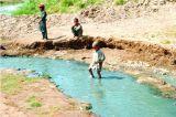
202 Forest Protection
203 Why Protect the Forest? Overgrazing by sheep and goats The animals will eat any young trees that are planted or that come up naturally in the forest.


204 Why Protect the Forest? Human damage People might break the trees when gathering pistachios or cut them for firewood in an unsustainable way. Sometimes children will damage them.
205 Why Protect the Forest? Fire Accidental fires in the forest can damage or kill the trees.
206 Why Protect the Forest? Insects and Disease These can damage a forest quickly if no monitoring is done.
207 How Can We Protect the Forest? Forester knowledgeable about management techniques, insects & diseases, and other forest information Guard keeps livestock and people from hurting the trees, watches for fire Fence Keeps out both animals and people Education local people need to be educated on why we manage the forests so they can assist in the care
208 Riparian Forest Buffers
209 What are riparian buffers? Riparian buffers are areas along a river, stream, lake, or wetland that are planted to trees. Their purpose is to provide shade for the water and the people, to clean muddy water from soil erosion before it reaches the river, to slow down flood waters, and to provide habitat for wildlife and birds.
210 Riparian Forest Buffer River W W W

211 Riparian Forest Buffer
212 How Do the Buffers Work? The trees slow down the water as it flows through the buffer so that the eroded soil particles have time to settle out of the water. The roots allow the water to soak into the ground better instead of just flowing over the ground.
213 How Do the Buffers Work? The trees also help slow down flooding that occurs along the rivers. The tree trunks break the speed of the flood water as it comes out of the river, and the slower water does not do as much damage to the land. The tree roots help to hold the soil in place and prevent scour erosion from fast moving water.
214 How Do the Buffers Work? The fallen leaves from the trees protect the soil from erosion and act as a filter to clean the soil erosion from the water. The leaves and branches that fall into the water are the base of the aquatic food chain. This food source enhances the habitat for fish and other aquatic animals.
215 How Do the Buffers Work? The shade from the trees cools the water temperature and also enhances the habitat for fish. The buffer of trees is good for land-based wildlife species because it creates new cover and food for them.
216 How are the Buffers Designed? The buffer should be at least 11 meters wide. Measure the distance from the top of the bank of the water body. The trees should be planted 3 or 4 meters apart. If there will only be 2 rows of trees in the buffer, be sure to stagger the planting for maximum tree coverage.
217 How are the Buffers Designed? The length of the buffer must be at least two times the width to function properly. Either pines or hardwoods may be planted in the buffer, but hardwoods work better because of their root types and the amount of leaves falling to the ground. Choose the kinds of trees that match the soil and the soil moisture. Do not allow the local population to gather more than ½ of the leaves that fall.