CRITICAL PATHS. ~ Enhancing Road Permeability for Wildlife in Vermont ~
|
|
|
- Natalie Cameron
- 5 years ago
- Views:
Transcription

1 CRITICAL PATHS ~ Enhancing Road Permeability for Wildlife in Vermont ~ Recommendations for On the Ground Improvements at Priority Road Crossing Zones in the Green Mountain Corridor This is a Draft Report. A Final Version Will Be Published After Stakeholders and Municipal Officials Have Provided Input. By George Leoniak, Principal, Leoniak Tracking Services Tina Scharf, Consulting Wildlife Biologist Jamey Fidel, Forest and Biodiversity Program Director, Jared Nunery, Markell Ripps, and Siobhan McIntyre, Interns Vermont Natural Resources Council George Gay, Director, Global Warming Program, Northeast Regional Center, National Wildlife Federation Forrest Hammond, Wildlife Biologist, Vermont Fish and Wildlife Department Jens Hilke, Conservation Planning Biologist, Community Wildlife Program, Vermont Fish and Wildlife Department August, 2009
2 I. Introduction Vermont s transportation system is an important and growing feature in the state. In the last quarter of the 20th century, Vermont expanded its road system by an average of 26 miles per year to a total of about 14,251 miles. The number of vehicle miles traveled by Vermont residents is growing at seven times the rate of population growth. As of 2008, Vermont had a total of 14,122 miles of public roadways, and 13 major roadways running east to west, bisecting large blocks of undeveloped lands that run north to south the length of the state. This expansive transportation infrastructure has the following negative impacts upon wildlife: vehicle-wildlife collisions; reducing animal and fish passage, thus limiting habitat availability and isolating populations; vehicle emissions of pollutants such as ozone and greenhouse gases; and facilitating the spread of an exotic, invasive species into otherwise healthy areas. The overriding goal of the Critical Paths project is to assist in the implementation of Vermont s State Wildlife Action Plan (SWAP) which specifically recognizes the impacts of roads on wildlife habitat, and identifies the need to prioritize road crossing areas for wildlife. Creating a more permeable landscape is essential to maintaining and improving the status of many Species of Greatest Conservation Need (SGCN) wildlife with declining populations; wildlife that are threatened or potentially threatened; and wildlife that are so little known in Vermont that experts cannot yet ascertain their status. Several terrestrial SGCNs in Vermont rely on safe road crossings to move within their core habitat, and many species will require better north-south connectivity to migrate in elevation and in latitude as the global climate changes. Establishing and protecting wildlife corridors in strategic locations will reduce the impacts of habitat fragmentation and associated population isolation on wildlife. Furthermore, reducing the impact of road kill on mammals, reptiles and amphibians of concern is vital to the recovery and success of many of these species, especially as the climate changes. A. Project Partners The National Wildlife Federation (NWF), U.S. Forest Service Green Mountain National Forest (GMNF), Vermont Agency of Transportation (VAOT), Vermont Fish and Wildlife Department (VFWD), and Vermont Natural Resources Council (VNRC) are working in partnership to maintain and restore habitat connectivity and identify and prioritize wildlife road 2
3 crossing locations in Vermont. To date, this work has been supported through a generous grant from the Wildlife Conservation Society through its Wildlife Action Opportunities Fund to assist implementation of several priority actions of Vermont s Wildlife Action Plan. Support to establish the Wildlife Action opportunities Fund was provided by the Doris Duke Charitable Foundation. Additional funding for the project includes a cost-share agreement between NWF, VNRC and the GMNF, and support from the Wallace Global Fund, Summerlee Foundation, and Ward M. and Mariam C. Canaday Educational and Charitable Trust. B. Project Location Biophysical regions (also known as ecoregions or physicogrpahic provinces) define areas that have similar geology, topography, soils, vegetation patterns, and climate. There are eight biophysical regions in Vermont. The Critical Paths study area includes the Northern Green Mountain and Southern Green Mountain biophysical regions (referred to collectively as the Green Mountain Corridor). The study area is characterized by ample rainfall, plateaus, foothills, medium and high peaks reaching above 4,000 feet. The Northern Green Mountains biophysical region has a cool climate and high elevations and is mostly forested. Northern hardwoods dominate the side slopes, whereas high elevations have spruce and fir as well as Alpine meadow habitat. Twenty-six percent of the region is conserved. The Southern Green Mountains biophysical region is a broad plateau dotted with a few dominant peaks and several ski areas. Climate is cold and rainfall is relatively high. Northern hardwoods, spruce, and fir dominate, and there are a number of small lakes and ponds. Thirty-three percent of this region is conserved. C. Project Overview The Critical Paths project is set up to utilize Geographic Information System (GIS) modeling and field research to prioritize critical north-south wildlife road crossings in the Green Mountain Corridor. The project s primary objectives at the outset were to: 1) identify and prioritize important crossing areas along the Green Mountains through an analysis of the Vermont Habitat Linkage Analysis data layer; 2) test the initial analysis through field research to determine where there are bottlenecks and impermeable crossings; and 3) develop strategies that will increase the permeability of 5-10 of these sites through land conservation, local land use planning, road mitigation, or other roadside improvements. As a final product, the project 3
4 intended to develop 5-10 site-specific management plans that increase connectivity at priority north-south wildlife crossing areas. II. The Importance of Habitat Connectivity to Wildlife Connecting habitat is land that links large patches of habitat within a landscape, allowing the movement, migration, and dispersal of animals and plants. Riparian habitat along streams and rivers, strips of forest cover between developed areas, and even hedgerows and fencerows, all represent potential connecting habitat. Often these areas are called corridors, even though they are not always linear, as the term implies. Corridors act as lifelines for isolated populations as they: allow wildlife to move freely across their range allow wildlife to colonize new habitat as climate change, succession, or other ecological processes force them to migrate reduce the risk of population isolation ensure the exchange of genetic information among populations allow wildlife access to foraging and breeding grounds facilitate seasonal movements (migrations) to essential range or habitat allow the dispersal of young adult animals from natal range allow adult animals to interact with potential mates, thus improving reproductive success and genetic fitness Corridors between large patches of habitat help ensure the ultimate viability of local wildlife populations. Wildlife travel corridors create a network of habitat connectivity, linking together both large and small patches of land, in both highly fragmented and highly connected landscapes. A. Current Pressures on Wildlife in Vermont Vermont is blessed with an abundance of forestlands, spanning the entire state, intermixed with agricultural and residential lands creating a mosaic pattern of land use. In total, nearly 80% of Vermont is forested. This wealth of forestland is largely a result of changing historic land use patterns, and a strong emphasis on the preservation of the working landscape. However, recent changes in development patterns have increased development pressure on forests. A shift in the last several decades away from clustered village centers to lower density 4
5 exurban development patterns and sprawling suburban development has significantly increased forest fragmentation. Exurban development, the unorganized scattering of homes on large parcels of 10 to 40 acres (Hilty et al. 2006), has become a common development pattern in rural Vermont, with seriously detrimental impacts to Vermont wildlife. Sprawl, a term used more broadly in regard to developmental patterns, is used to describe dispersed, automobile-dependent development outside of compact urban and village centers (Smartgrowth Vermont). Sprawl, a highly energy and resource intensive land use, not only fragments human communities, but also increases the fragmentation of open lands and wildlife habitat. Changes in Vermont land use patterns have been fueled by the construction of thousands of new homes. In 1970, there were 165,063 housing units in Vermont (Vermont housing data website). By 2000 this number had increased to 240,634. From 1960 to 1990, Vermont s rural population increased by 59% (Smartgrowth Vermont). The significant increase in total housing units reflects the observed changes in development patterns in rural and suburban areas. More recent data suggests that this trend will only worsen over the next 20 years as population growth coupled with exurban and sprawl development continues to carve into extant contiguous patches of forests in Vermont (Stein et al. 2005). This type of development necessitates the construction of new roads, which increase habitat fragmentation as the roads dissect contiguous blocks of core habitat that are critical to the survival of a multitude of native species. Recognizing the serious pressures present on wildlife, it is vital that connectivity between existing large tracts of habitat is maintained. Though the thin linear nature of roads may create an illusion of having a small impact on adjacent lands, the linear bisection of contiguous blocks of habitat caused by roads disproportionately impacts numerous species of wildlife. Research has shown that roads affect wildlife in a number of different ways ranging from increased mortality from road construction and collisions with vehicles, to modifications in animal behavior (Trombulak and Frissell 2000). In the U.S., roads cover approximately 1% of the landmass (Forman and Deblinger 2000). In the U.S., road mortality exceeds hunting as the leading direct human cause of vertebrate mortality, with approximately one million deaths daily (Forman and Alexander 1998). Collisions with wildlife pose a serious threat for both wildlife and humans. Minimizing wildlife vehicle collisions through proper planning increases the safety of roads, benefiting both wildlife and drivers. Reduced collisions financially benefit local municipalities as well as the state. Fiscal 5
6 benefits are obtained through reduced insurance claims, increased hunting and fishing license revenues from healthy game species populations, and reduced bridge and culvert maintenance costs (Vermont Wildlife Action Plan 2005). Reduced costs associated with decreased vehicle collisions with wildlife should be considered when evaluating financial costs of the construction of wildlife crossings. B. Consequences of Habitat Fragmentation Reduced connectivity between habitats as a result of the fragmentation caused by roads has serious impacts on wildlife populations at a variety of spatial and temporal scales. In the short term, habitat fragmentation can restrict species access to critical seasonal habitat. For example, black bear require different seasonal habitats including mast stands during summer and fall months, and den areas in winter months. Roads can act as a barrier between necessary habitats, restricting access to essential habitat for survival. In a greater temporal scope, habitat fragmentation can restrict genetic flow between populations and limit migratory capabilities. Both of these can significantly influence the long term viability of localized populations. Another important distinction is the difference between habitat connectivity and landscape permeability. At the broader landscape scale, habitat can appear to have connectivity; however, the bisection of roads creates an impermeable landscape, as species are unable to access habitat as a result of the habitat bifurcation created by roads (Cramer and Bissonette 2005). A permeable landscape is one that allows the free movement of the complete suite of local fauna, facilitated by accessible and functional wildlife crossing points at road/habitat intersections. Coupled with the effect of land use, climate change will likely have significant impacts on wildlife in Vermont. In a changing climate, increased connectivity and permeability can mean the difference between species survival and local extirpation. Since 1970, the northeast has been warming at a rate of 0.5 F per decade (winter temperatures are rising 1.3 F per decade) (Hayhoe et al. 2006). A study conducted by the Union of Concerned Scientists (2006) on the Northeast, compared regional climate change scenarios under different projected greenhouse gas (GHG) emissions levels. They found that under varying anthropogenic GHG emission scenarios, annual temperatures are projected to increase 3.5 to 12.5 F by This same study showed a host of other impacts resulting from anthropogenic emissions of GHGs; perhaps most notably was the migrating states theory, where in 2100, under continued high emission scenario, 6
7 Vermont would have a similar climate to present day Tennessee (Hayhoe et al. 2006). Furthermore, increased disturbance regimes both in intensity and frequencies resulting from climate disruption may further exacerbate species habitat loss, making migratory corridors even more crucial. The free movement between habitats will facilitate individual species ability to adapt to a changing climate. This is especially important along south to north corridors, where migration along a latitudinal gradient may be vital to species range shift in response to climate change. C. Mitigating the Effect of Habitat Fragmentation by Roads Road ecology is a relatively new subdiscipline of ecology that explores and addresses the relationship between the natural environment and the road system (Forman 2003). Numerous research projects have investigated ways to reduce and mitigate the negative impacts of roads on adjacent ecosystems, including wildlife. As a result of this work, a variety of techniques have been identified to increase habitat connectivity, including identifying high crossing areas, raising driver awareness of wildlife, and constructing wildlife crossings. The latter of these techniques, constructing wildlife crossings, has a variety of forms ranging from passive techniques like increasing road signage and reducing road speed, to more active techniques such as constructing underpasses and overpasses to facilitate wildlife crossing (Cavalloro et al. 2006). No one crossing will perfectly suit all species types; however, techniques exist that help attract a larger variety of species to crossings. These include using appropriate substrate on overpasses and in underpasses, intentional design and management of adjacent vegetation to the crossing structure, and the appropriate sizing and width of crossing structures relative to target species (Austin and Garland 2001). Currently, a variety of wildlife crossings are being used throughout North America and Europe to increase habitat connectivity and permeability. In North America, a recent study found that as of 2005 there were at least 460 terrestrial and 300 aquatic crossings (Cramer and Bissonette 2005). At the same time period in Vermont, nine crossing structures had already been completed or were near completion, with a half dozen scheduled for construction by 2010 (Cramer and Bissonette 2005). As the construction of any form of crossing comes at a financial expense, adequate planning ensures fiscally sound mitigation efforts, and targets limited funds on areas of greatest need (Feinberg 2007). For this reason, the first step should be to identify 7
8 existing habitat, as well as probable hot spot areas of wildlife crossings where major roads bisect quality habitat. In Vermont, VFWD in collaboration with VAOT identified areas of quality habitat, as well as areas adjacent to public roads between quality habitats. However, this work currently exists as a database, and further analysis is needed to identify which crossing areas are in greatest need of attention. III. Outreach and Interaction with VAOT and Municipal Officials The VFWD and VAOT regularly work with municipal officials on the issue of road permeability for wildlife, and both agencies are part of a cooperative agreement that developed an interagency steering committee to address road and wildlife impacts. In addition, both agencies participated in the 2004 Northeast Transportation and Wildlife Conference in Fairlee, Vermont and cooperatively published the Conference Proceedings. Likewise, all project partners have been lead cooperators in the ongoing Vermont Forest Fragmentation Roundtable that has also highlighted road-related issues. Partner biologists have participated in VFWD/VAOT joint field training on wildlife and roads. Even though VFWD and VAOT have a cooperative agreement throughout Vermont, the need to prioritize important linkage areas still exists, identify where wildlife crossings are not successful, and mitigate impacts on areas that are not current VAOT projects. Many improvements are needed to allow for successful movement of wildlife across roads, but only non-government organizations and municipalities can apply for enhancement grants to improve wildlife crossing areas. An important aspect of the Critical Paths project is to provide outreach and technical assistance to government officials and VAOT personnel to raise awareness of the priority crossing zones and management and conservation strategies. Some of this work occurred during the research phase of the project, and additional outreach is continuing with municipalities, government officials and citizen groups in identified priority areas. Project partners have met with the Cold Hollow to Canada Steering Committee to begin coordination on conservation and planning opportunities for Priority Crossing Zones 2 and 5. (See section IV. Methodology for a definition of the term Priority Crossing Zone and see page 13 for a locator map of all Priority Crossing Zones.) An initial planning meeting in June of 2009 brought together project partners and representatives from seven towns in the Northern 8
9 Green Mountains biophysical region to identify the two northern priority crossing areas and discuss regulatory and non-regulatory management strategies for conserving or managing land within the identified crossing zones. Future meetings will promote habitat connectivity planning for the priority crossing zones. Project partners have begun coordination with the Mendon Planning Commission to discuss planning and zoning options and management considerations for Priority Crossing Zone 27. Staff from VNRC met with the Mendon Planning Commission on August 3, 2009 to review recommendations to make Mendon s zoning bylaws more comprehensive for wildlife protection, and to discuss concrete strategies that can be employed in the town plan and zoning bylaws for Priority Crossing Zone 27. Project partners have entered into a cooperative partnership with the GMNF to address management and conservation strategies for Priority Crossing Zones 21, 25, 35, and 37. The partnership is designed to implement management strategies for the priority crossing zones in coordination with local municipal officials, VAOT personnel, VFWD wildlife biologists, and GMNF wildlife biologists and planners. This is the first cooperative partnership with such diverse partners to share information and address habitat connectivity for identified priority crossings on the GMNF. Project partners have coordinated with the Forests, Wildlife, and Communities Steering Committee in the Mad River watershed to discuss Priority Crossing Zone 20. The Steering Committee, which includes municipal officials from four towns and the regional planning district, is currently developing a landscape level conservation map for wildlife linkages across the towns in the Mad River Watershed. Future education and outreach efforts will promote the importance of Priority Crossing Zone 20. Technical assistance and outreach efforts will continue in the above priority crossing zones, and additional efforts will be made to promote strategies in Priority Crossing Zones 5, 9, and 30 in the near future. Finally, project partners convened a state wide Climate Change Adaptation Conference, Safeguarding Vermont s Wildlife and Natural Systems in a Warming World, on March 23, 2009 to promote new strategies for addressing wildlife permeability across the Vermont landscape. The conference was well attended and the Critical Paths project was showcased as a major initiative that is being implemented to promote wildlife adaptation in Vermont. Members of the 9
10 land trust community, state government, federal wildlife and land management agencies, conservation community, land use and transportation planners, and municipal officials learned about the project and opportunities for addressing habitat connectivity and permeability across the Green Mountains. As result of this conference, Meg Mitchell, Forest Supervisor on the GMNF, directed her wildlife staff to become involved in the emerging Vermont Climate Change and Wildlife coalition. And, as noted earlier, GMNF has contributed financial support for Critical Paths. IV. Project Methodology for Determining Priority Crossing Zones A. GIS Analysis Initial GIS work was critical in identifying specific road sections to be visited during fieldwork. Each road section included multiple crossing zones. The starting point for this GIS analysis was the Wildlife Crossing Value (WCV) shapefile that was part of the Wildlife Linkage Habitat (WLH) analysis created as a joint venture between VFWD and VAOT. This included a statewide habitat suitability model as well as the derived wildlife crossing value that showed areas that were likely to be suitable crossing areas based on the proximity of adjacent higher quality, close-to-the-road habitat. The project partners classified the values in the WCV as presence/absence of crossing areas, generalizing the positive values of 5-10 as presence of a wildlife crossing zone. This was done to recognize the limits of the WLH model given that its ability to detect a crossing area was based only on land cover & human population density. Given these many crossing zones as starting points in the selection process, the project partners then used a variety of datasets to predict more specific crossing areas within each zone and focus fieldwork efforts there. Wildlife Habitat Suitability, Habitat Blocks, E911 houses, NOAA CCAP Land cover data, Contours, Wetlands and Hydrology were reviewed by the field team and several specific study areas were identified along each road crossing zone. GIS layers were shown cumulatively and assessed for concurrence of key factors as identified by the field team (Table A). This was a dynamic process, weighing expert opinion in how to prioritize the following factors: relatively flat areas, near wetlands, close evergreen cover on both sides of the road, no houses within 50m, and access to larger conserved habitat blocks on each side of the road, and but many sites were chosen based on a few rather than all of these preferred traits. 10
11 Table A. Criteria used to evaluate existing GIS layers and identify initial group of crossing zones. Map Layer Look For: Importance Habitat Suitability Suitability rating 6-10 High Conserved Lands National Forest, State Parks, Land trust High etc. Wildlife Crossing Value Value 5-10 Medium Landuse/Landcover Coniferous and mixed forest covers Medium Wetlands Within m of the road Medium Topography Moderate to Gentle slopes; Stream Medium drainages and ridges perpendicular to the road Road Kill Concentrated areas of animal vehicle Medium collisions Transmission Lines Perpendicular to the road Low Bridges/Culverts Bridges and culverts Low In total, 124 crossing zones were identified within the Green Mountain Corridor. Eighty of these occur on north south roads and were eliminated from the potential fieldwork list. Six of these occur on Interstate 89 and were eliminated from the potential fieldwork list given the need for an independent and more thorough study of the Route 2/ Interstate 89 crossing area. This is the single greatest fragmenting feature to north-south habitat connectivity in Vermont and potential solutions to this area will likely be complicated and expensive. Thus, 44 crossing zones on 13 roads sections were selected for a thorough review and revision process. No more than four discrete crossing zones were identified within each road section. A map depicting all of the identified roads and associated crossing zones in the Green Mountain Corridor considered during this phase of the Critical Paths project titled Wildlife Road Crossings is attached as Appendix A. 11
12 B. Preliminary Field Work, Interviews, and Crossing Zone Revisions Interviews with VAOT staff, VFWD personnel, and local hunters were conducted along 13 road sections within the study area. At the meetings, the intention of the Critical Paths project was discussed with the representatives and maps of crossing zones discovered during the GIS analysis were presented. Information was collected on the whether or not the crossing zones identified during the GIS analysis matched the observations of the informant. Informants were also asked about other crossing zones that may not have been detected during the GIS analysis steps, and if they had any information on problem areas, locations of roadkill, live sightings of wildlife, condition of bridges and culverts, and sections of road that could be improved. When possible, informants would drive with a field researcher, and GPS coordinates, pictures, and field notes were collected. These meetings refined the locations of the crossing zones detected during the GIS analysis, and finalized the 38 crossing zones that would be surveyed during the winter and spring field months to develop a small set of Priority Crossing Zones. C. Winter and Spring Protocols The project partners developed seasonal tracking protocols to ensure that winter and spring field data was collected using similar techniques so that they could be consistently interpreted from season to season, region to region and zone to zone. The main goal was to detect signs of Species of Greatest Conservation Need according to Vermont s Wildlife Action Plan, but field biologists recorded all wildlife species that were detected, including common species that would bolster the significance of the area for wildlife, or present specific management issues or concerns. The Winter Protocol is attached as Appendix B and the Spring Protocol is attached as Appendix C. D. Selection Process of Priority Crossing Zones State wildlife officials and consulting biologists analyzed the available data within ArcGIS for each of the 38 crossing zones. Priority crossing zones were determined from this group by evaluating the winter and spring survey data in relationship to available GIS layers such as: roadkill, topography, conserved lands, wetlands inventory, and core habitat. The major criteria used to select priority crossing zones focused on areas that showed high species use and diversity during the surveys, as well as core habitat connection with undeveloped land on either 12
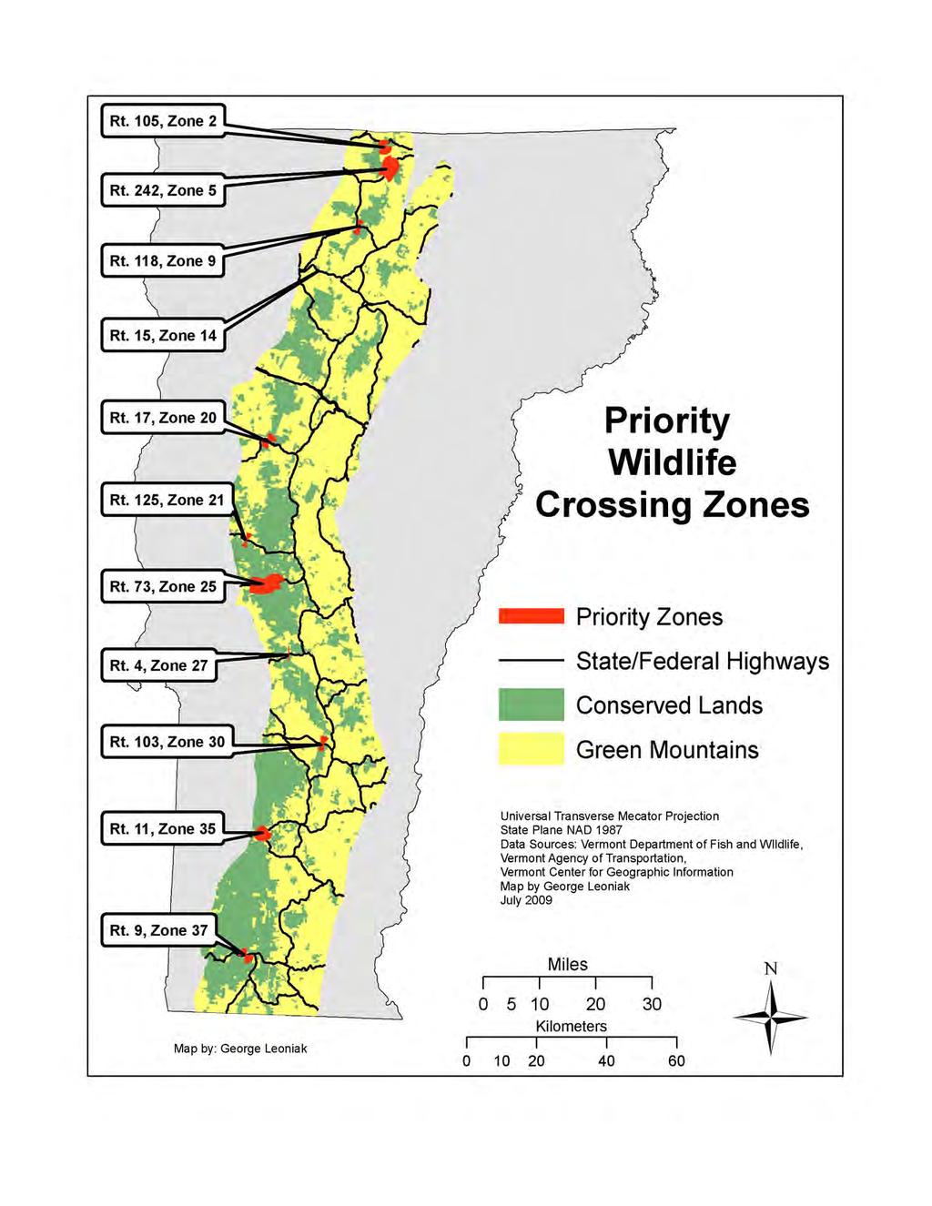
13 side of the road. Contributing factors that influenced the selection process were related to the presence/absence of these features: conserved land, wetlands, bridges/culverts, guardrails, and animal vehicle collisions. The team also examined which crossing zones might be in need of a management plan, because the zone posed a threat to human safety. Crossing zones that presented opportunities for outreach and partnerships were also considered during the prioritization process. Based on these analyses, 11 of the 38 crossing zones were selected as priority crossing zones, and specific management plans for each of these locations are presented in the following section. Only 2 of the 13 road sections reviewed (Routes 108 and 109) do not contain a priority crossing zone because the zones on these routes did not meet the criteria used to select priority zones. The Priority Crossing Zones are distributed throughout the Green Mountain Corridor as noted on the Priority Wildlife Crossing Zones Map below. 13
14
15 V. Management Plans The project area, Green Mountain Corridor, was divided into three separate regions for purposes of Critical Paths. One of the primary goals of the Critical Paths project is to develop management plans specific to each Priority Crossing Zone. These management plans include a description of the zone s physical features, highlights of anecdotal reports and field data, and ecological as well as regulatory management recommendations that will encourage increased permeability of these Priority Crossing Zones. The work presented in the management plans, if acted on, can play a key role in increasing habitat connectivity throughout the Northeast, and benefit the long-term viability of numerous SGCN in Vermont. The Northern Region included the following Priority Wildlife Crossing Zones: Zone 2, Route 105; Zone 5, Route 242; Zone 9, Route. 118; and Zone 14, Route 15. Management plans for these zones are noted below. Priority Crossing Zone 2 ~ Route 105 ~ Town of Jay Zone Description and Conditions Priority Crossing Zone 2 encompasses a large corner on the western slope of Route 105. Route 105 is a two-lane highway with a 50 mph speed limit. The road within the zone slopes moderately to the west. Vehicular speed is generally less than the posted limit because of the corner, the slope of the road, and warning signs signaling a curve. There are no wildlife crossing signs. The sight distance is short, although the corner itself is broad. The paint lines are in relatively good condition. The only guardrails are fairly short. This stretch of road is located in an undeveloped area; the nearest buildings to the west are about two miles away and there are no buildings for approximately five miles to the east. Route 105 is a major east-west truck route for the northern border region of Vermont; thus there is a fair amount of traffic even though the road passes through a mountainous, wild area. Vegetation is mostly deciduous woodland. The terrain slopes from south to north, and two culverts carry water northward. A well-used salt lick exists on the north side of the road on relatively flat ground. The lick is located in a pullout where there is no cover. The salt lick water drains downslope into one of the streams. A well-worn game path comes down a moderate slope opposite the lick on the south side of the road (Photo 2). Moose also access the lick via a tote road on the south side of the road. Wet ground extends west of the lick on the
16 north side of the road, where there is a wide grass verge that is also used by wildlife. VAOT personnel report that bear use a lick in the woods down slope of the roadside lick. A map of Priority Crossing Zone 2 appears on the following page. 17
17
18 Anecdotal Reports VAOT personnel Pat Donovan (Westfield) and Dwight Robtoy (Enosburg) identified this zone. Pat stated that moose lick road salt in the winter. There was a cow moose with a calf in the road throughout the winter of that motorists had to drive around to avoid hitting. Dwight spoke to a bear hunter who provided information about bear. Houndsman Gary Greenwood of Essex Junction also provided information on bear and bobcat activity in the area. A VFWD game warden had just been assigned to the region and therefore felt he had no additional information. Summary of Tracking Surveys Abundant moose activity was observed during three spring surveys. Additionally, the NWF team made a short July visit to assess road conditions. The surveyor observed a moose at the lick in early June (Photo 1). Besides moose activity, there were deer tracks in the lick and a coyote track was found on the west end of the zone. Physical Management Strategies Wildlife using this zone are somewhat protected because the corner slows traffic speed, but improvements could still be made. Wildlife crossing signs on both ends of the zones would help alert motorists. The white fog-line paint should be kept in good condition and could be broadened. Reflectors on posts could be added to both sides of the road to increase motorists ability to see obstacles in the dark. The main wildlife attractant to this zone is road salt. For a longer-term solution, an alternative road de-icing agent could be used. There would thus be less concentrated wildlife usage, resulting in fewer collisions and safer conditions for both wildlife and motorists. Policy Overview The town of Jay repeatedly emphasizes the need for the protection of natural resources throughout their Town Plan. The theme of protection is applied in a broad context, often without the mention of wildlife in particular. However, a great deal of attention is given to the two major road corridors within the town, Routes 105 and 242. Route 242 is specifically addressed as the backbone of the town, as this is the primary access corridor for recreationists traveling to the 20
19 Jay Peak Mountain Resort. Though the town does acknowledge the negative impacts of habitat fragmentation and the necessity of travel corridors for the long-term viability of wildlife populations, it does not include any specific policies or implementation mechanisms to ensure or facilitate habitat connectivity. Within the land use development regulations are road standards, however, these standards do not specifically address wildlife or habitat connectivity. Additionally, the zoning bylaws delineate five distinct zoning districts. The two proposed wildlife crossings in this study lie in the Rural District 1 (Priority Crossing Zone 2), and the Recreational District (Priority Crossing Zone 5). Neither of these districts addresses wildlife within the descriptions or criteria. Both of the zoning districts have relatively small minimum lot sizes (Rural District 1 = 3 acres; Recreational District = 1.5 acres). Though the zoning regulations do require a site plan review, this review does not address wildlife or the issue of habitat connectivity. Policy Recommendations To whatever degree lands have not been conserved in the wildlife corridor, seek conserved status with a willing landowner and conservation partner. Recognize the location and significance of the wildlife crossing and seek to implement specific management and/or conservation strategies in the town plan. Define with specificity the species using the wildlife corridor in the town plan. Adjust site plan review process in the zoning regulations to minimize undue adverse effects to functions of the corridor for wildlife movement. Incorporate wildlife protection standards in the zoning regulations. For example, follow Accepted Management Practices in all silvicultural operations and require mandatory consultation with the Vermont Fish and Wildlife Department and Department of Transportation prior to any major road maintenance. The creation of a new VT 105 and VT 242 Road Corridor District would be another way to help regulate development near critical habitat adjacent to or within Crossing Zone 2. The Jay Town Plan explicitly describes the relative importance of these two roads both ecologically and economically. The town recognizes that tourists are attracted to this area because of the scenic beauty and recreational opportunities. Establishing a specific 21

. However, the rest of the land is fairly wild.")
20 zoning district for these two major human travel corridors within the town would also benefit wildlife travel corridors adjacent to these roads. Photo 1. Moose at salt lick in zone 2. Photo 2. Game trail across from salt lick. Priority Crossing Zone 5 ~ Route 242 ~ Town of Jay Zone Description and Conditions Route 242 passes through a large block of forested habitat. To the west is the small town of Montgomery Center. Jay Village is to the east near Route 100. Jay Peak Ski area is near the summit, and has a good deal of related development (such as condos and hotels). However, the rest of the land is fairly wild. Some of the surrounding forest is held by the State as Jay State Forest. Atlas Timber Company owns thousands of acres. The company has conserved some of its property, although not right up to the edge of Route 242. Priority Crossing Zone 5 encompasses the upper elevation of Route 242, including the summit. The east end of the zone is just below Jay Peak Ski Area s main entrance. Route 242 is a two-lane highway with a 50 mph speed limit. The upper section is a sometimes steep and curving mountain road. Sight distances within Zone 5 are mostly short. Traffic speeds vary, depending on road conditions. The mountains slope to the east and south, so that the land falls away from the eastbound lane. Trees come right to the road in most places, with either a very narrow, or no, grass verge. There are a couple of moose crossing signs, but 22
21 this zone is long, and signage is minimal considering the distances involved. The paint lines are presently faded. Guardrails are generally short on the west side of the summit. On the east side of the summit there are two long sections of guardrail. There are several culverts within the zone, some of which are fairly large and carry a large volume of water. A map of Priority Crossing Zone 5 appears on the following page. 23
22
23 Anecdotal Reports Informants for Priority Crossing Zone 5 included VAOT personnel Pat Donovan of the Westfield garage, Dwight Robtoy of the Enosburg garage, VFWD Game Warden Carl Wedin, and bear hunter Gary Greenwood. All informants stated that wildlife crossings were dispersed over a long stretch of Route 242 because it passes through such a large, uninterrupted habitat block. Wildlife uses much of the area as primary habitat; that is, near the top of the mountain there are no constricted places that animals must use to cross the road. Therefore this zone is quite long. Roadkill is limited; only one moose is recorded in VFWD records. However, everyone also stated that a variety of species has been observed over the years including fisher, bear, moose and deer. The VAOT supervisors pointed out two places where there were salt licks, and these were confirmed in the spring. One of the salt licks is over a bank on a corner above the entrance to Jay Peak Ski Area. This is a potentially dangerous spot for both motorists and wildlife. Summary of Tracking Surveys Priority Crossing Zone 5 was surveyed three times in the spring. Additionally, the NWF team made a short July visit to assess road conditions. Salt licks were very active and two more were recorded besides the ones pointed out by Pat Donovan and Dwight Robtoy (Photo 3). Moose were quite active around the licks. There was much moose browsing by the licks, but also in other places. A red maple had been bark-stripped by a moose right across from the upper Jay Peak parking lot entrance. Also near the entrance a white-tailed buck had rubbed a small tree. A road-killed skunk was found below the main ski area driveway. There were two game trails found that were made by smaller mammals, i.e., furbearers. A road-killed garter snake was also found. Physical Management Strategies Some parts of Priority Crossing Zone 5 appear to be fairly safe for wildlife to cross. Traffic speed is kept down because of the curves and steepness of the road, and there are no guardrails (Photo 4). Brighter paint would be useful throughout. Various sections of the zone might benefit from increased signage (especially near the salt licks) and removal of trees and thick vegetation from the edge of the road to increase visibility. If any culvert work is to be 25
24 done, VAOT should consult with VFWD to construct culverts that can wildlife can more easily utilize. The long guardrail on the eastbound lane just above Jay Peak Ski Area would benefit from some gaps to increase permeability and safety for both wildlife and motorists. The salt lick on the large corner above Jay Peak Ski Area is below that guardrail and has particularly poor visibility. Efforts could be made to drain that lick, or if that s not possible, warning signs at that location might help. Policy Overview For an overview of Jay s Town Plan and Zoning regulations see the Policy Overview discussion for Priority Crossing Zone 2 above. Westfield s Town Plan identifies natural areas and corridors and notes that these areas are valuable habitat for wildlife species. In addition, the Town Plan recognizes that uninterrupted habitat apart from humans provides wildlife with areas for travel and food. In particular, the Town Plan identifies fisheries, the Missisquoi River flood plain and the woods and higher elevations on the west side of town provide relatively uninterrupted habit for upland habitat as natural areas that support wildlife. This last area, on the west side of town, may correspond to Priority Crossing Zone 5, depending on how this broad description is defined. Priority Crossing Zone 5 lies within Westfield s recreational-residential district. Westfield currently does not have a zoning map, but the recreational-residential boundary description encompasses this zone. There is no mention of wildlife in either the general zoning purpose statement or in the district purpose statement. Commercial accommodations and family dwellings are permitted uses in this district and conditional uses include retail and manufacturing. Westfield does not have a conservation district; additional districts are village and rural-agricultural. Rural-Agricultural is the most development restrictive, yet it still allows commercial accommodations and dwellings as a permitted use and light manufacturing as a conditional use. Zoning contains Conditional Use Review standards and Site Plan Review. As part of the process, developers must identify existing features. Westfield has not adopted subdivision regulations. 26
25 Policy Recommendations Neither Jay nor Westfield has adopted subdivision regulations that incorporate the protection of wildlife habitat. Both towns should establish subdivision regulations that include site plan review criteria that specifically address and define critical wildlife habitat, which should include this priority crossing zone. This will help control development and subdivision along the Route 242 corridor. Though the crossing zone is entirely encompassed by the Jay State Forest within the town of Jay (it is not within the town of Westfield), the conserved land width could be extended. Purchasing the development rights on lands adjacent to the Jay State Forest would create a buffer around the crossing zone, and guarantees that this area remains as forested habitat. Vermont Fish and Wildlife Department and the Town of Jay should work with the Jay Peak Ski Resort to ensure the long-term protection of lands nearby the crossing site. Additionally the town could work with the State to discuss forest management plans for the land adjacent to the crossing site. The portion of this crossing zone within the Town of Jay lies within the Recreational District. The primary focus of this district is to regulate development associated with the Jay Peak Ski Resort. For this reason, it is imperative that the Resort is aware of this crossing site, as well as included in discussions of how to improve habitat permeability within this area. For other recommendations for the Town of Jay please see above (Priority Crossing Zone 2). Westfield should recognize the location and significance of the wildlife crossing and seek to implement specific management and/or conservation strategies in the town plan. Westfield should define with specificity the species using the wildlife corridor in the town plan. Westfield should consider re-zoning around the corridor to limit density and uses that are traffic generators. The current recreation-residential district encourages strip development. The zoning district surrounding the corridor should encourage minimal development densities and uses, and encourage road frontage requirements to maintain undeveloped road frontages. Westfield should zone this area as a rural-agricultural district, Westfield s 27

26 most development restricted district. The town could also consider adopting a conservation district to surround this area. In addition, Westfield should develop site plan review standards to minimize undue adverse effects to the functions of the corridor for wildlife movement. Photo 3. Salt lick in zone 5. Photo 4. Open road at Route 242 summit. Priority Crossing Zone 9 ~ Route 118 ~ Towns of Belvidere and Eden Zone Description and Conditions This area is a well-known wildlife area called Moose Alley. An extensive wetland on both sides of the road is rich habitat for a number of species. There is a large box culvert at the intersection of Routes 109 and 118 (Photo 5). There are three houses on the west end. There are no guardrails except for very short sections by two culverts. The eastern half is the most-used part of the zone because the wetland comes close to both sides of the road and the cover is better. The cover is mixed, but mostly coniferous, trees and small deciduous shrubs. The westbound lane grass verge is about 30 feet wide. In winter this verge is used as a snowmobile trail. The west side of the zone does not have good cover because there are large banks covered with grasses where there was a cut made to construct the road. Small trees are beginning to grow on these banks. The entire stretch of this two-lane highway is quite flat and traffic tends to move fast, often likely more than the 50 mph speed limit. The sight distance for motorists is long (Photo 6). VAOT has installed moose crossing signs. Road paint is faded. A map of Priority Crossing Zone 9 appears on the following page. 28
27
28 Anecdotal Reports VAOT Eden supervisor Gerry Moran, VFWD Game Warden Dennis Reinhardt, and bear hunters Mike Lamere and Gary Greenwood shared their knowledge of this zone and others on Route 118. Gerry and Mike had seen fisher and bobcat near the box culvert. Gary and Mike both stated that bear also use Moose Alley. There are two VFWD records of road-killed moose in this zone. Summary of Tracking Surveys Six tracking surveys were done in Priority Crossing Zone 9, three in late winter and three in the spring. Additionally, the NWF team made a short July visit to assess road conditions. A bobcat crossed over the road by the box culvert in late winter. This animal may have used the culvert if the ice had been solid. Beaver, mink, skunk and raccoon sign was found in the vicinity of the culvert. Some of these animals had gone through the culvert on thin ice. In the spring moose were also crossing here, and there was a small lick on the west side of the culvert on the south side of the road. Coyote tracks were found throughout the zone in winter. The coyote(s) apparently were hunting along the grass verge probably there are small mammals in the grass and shrubs. Also in winter mink, snowshoe hare and turkey tracks were found along the eastern half of the zone. The mink went over the road and also used a metal culvert. In the spring moose sign was so ubiquitous that it probably erased sign of smaller animals. There were numerous game trails on the south side of the road in the wetland area. Deer tracks and pellets were also present. Peepers, green frogs, and an eastern newt were observed, but no road-killed amphibians were found. The surveyor found a road-killed cow moose in the wetland area in June, 2009 (Photo 6). Physical Management Strategies This zone crosses through a rich wildlife habitat. As such, there is greater potential for road kill. Considering all the wildlife activity, we recommend that this zone have very large wildlife-crossing signs with yellow blinking lights. A slower posted speed limit could help, but it would have to be vigilantly enforced to have an effect because motorists are not inclined to drive slowly along this straightaway. Alternatively, speed tables could be installed if they were 31
29 broad enough not to interfere with plowing. Bright, wide painted fog lines would of course be helpful. No change in vegetative management is recommended as the grass verges and ditches are relatively wide. As a short term solution, a shelf in the box culvert would allow smaller mammals to use the culvert instead of having to cross over the road. A better, longer-term solution would be to replace the culvert with a bridge that has some dry-land passage. The culvert is in a small dip, and that could be filled in so that the sight line for motorists would be improved. The upstream bank by the culvert is eroding, meaning it is too small for large storm events. Eventually this culvert will need to be replaced even though it is relatively new. Policy Overview Priority Crossing Zone 9 spans a short section of roadway along the town boarders of Eden and Belvedere on Route 118. According to the Eden Town Plan, this section of roadway has seen a 7.9% decline in annual average daily traffic over the past decade. Both towns similarly address the negative impacts of habitat fragmentation on wildlife populations. Additionally both of the town plans recognize the importance of habitat connectivity and travel corridors to wildlife populations. Though neither town describes a specific policy for maintaining or facilitating habitat connectivity, both towns express concern for the need to protect and maintain viable wildlife populations. One of the goals listed in the Eden Town Plan is to, maintain the native diversity of wildlife throughout Eden through the protection of critical habitats. Both towns, with collaboration from the Lamoille County Planning Commission, have completed a full inventory of existing bridge and culvert conditions, which should be incorporated into any long term management plans for wildlife crossings. Despite a strong emphasis on protection of wildlife populations, both Eden and Belvedere lack zoning bylaws to enact these goals. Currently neither town has zoning or subdivision regulations, and this is a critical first step in facilitating the implementation and long-term protection of wildlife populations in this area, and specifically at the crossing site on Route


30 Policy Recommendations Both of the Eden and Belvidere Town Plans should acknowledge the importance of wetland and riparian buffers, specifically the role they play as travel corridors for wildlife between critical habitats. The towns should consider implementing subdivision regulations to establish adequate wetland and riparian buffers, and specific wildlife review standards to protect the local fauna and the wildlife crossing. Over the long-term as development pressures increase, the town should consider implementing zoning regulations that would include standards specific for the conservation of wildlife, critical habitat, and this priority crossing zone. If zoning is enacted, the town should consider enacting a Conservation District that incorporates the land adjacent to the crossing site on route 118. Photo 5. Box culvert at west end of Zone 9. Photo 6. Straight road and road-killed moose. Priority Crossing Zone 14 ~ Route 15 ~ Town of Cambridge Zone Description and Conditions Priority Crossing Zone 14 is located on Route 15 just west of the Johnson town line. Route 15 between Jeffersonville and Johnson is problematic from a wildlife habitat connectivity standpoint. This busy two-lane highway runs through the Lamoille River Valley. The river has a wide floodplain that is intensively farmed. Miles of cornfield and some hayfield separate extensive forested wildlife habitat on both sides of the valley. Besides the Winooski River with 33
31 Interstate Highway 89 and Route 2, the Lamoille River Valley is the most significant barrier to wildlife movement in the Green Mountain Corridor. VAOT personnel and VFWD game wardens report that wildlife-vehicle collisions can happen anywhere along this section of Route 15. The south side of the road is mostly forested and the land rises quickly to a long ridge that continues several miles to Madonna Mountain. On the south side of the road the land falls away quickly to the floodplain fields where there is little cover most of the year. Some hedgerows along the fields provide a bit cover year-round, but in late summer the cornfields provide abundant cover. Ripe corn is a major attractant to several species including bear and deer. The majority of wildlife crossings of Route 15 therefore occur from August until corn harvest. In addition, there are some apple trees on the north side of the road that attract wildlife through the fall and into early winter. Route 15 is fairly developed between Jeffersonville and Johnson, with many houses and farms and also development along side roads that climb up the southern slope towards the ridge. There are few stretches of road that are free from human structures and impact. Traffic is heavy with many trucks; and motorists often travel faster than the 50 mph posted speed limit. The shoulders are narrow and trees often come right to the road edge on the south side, limiting visibility. We hesitated to recommend an over-the-road crossing zone on this stretch of Route 15 when we felt there would be no effective way to improve permeability or safety for either wildlife or motorists. However, bear hunter Mike Lamere of Belvidere pointed out the Smith Brook ravine that has been filled in to level the highway. The road surface is about 30 feet higher than the ravine bottom. Presently there is a four-foot square concrete culvert under the road (Photo 7). It is showing signs of wear and appears to be too small for large storm events, as evidenced by erosion around the entrance. On the south side of this feature the ravine is steep sided, with a forested wetland at the bottom. There is a house above the ravine, but it is out of sight. On the north side of the road the wetland broadens a bit and there is open marsh, alder, deciduous woods and no nearby structures. All this provides good cover for wildlife approaching the road. South of this ravine is a narrow band of woods that connects to the large forested ridge. On the north side of the road there is also a narrow corridor of trees that connects to better cover in the floodplain. Conservation of these thin bands of cover would improve the value of this crossing considerably. 34
32 The road within the zone is bounded by two curves, with a short sight distance and guardrails lining both sides. The road dips a bit as it goes through/over the ravine (Photo 8). A map of Priority Crossing Zone 14 appears on the following page. 35
33
34 Anecdotal Reports Informants for Route 15 were VAOT Cambridge Garage supervisor Mike LeClair, VFWD Warden Dennis Reinhardt and bear hunter Mike Lamere. All of them stressed that wildlife crossed in many places along the stretch of Route 15 between Jeffersonville and Johnson. There have been several collisions around the VAOT garage, but that is probably because it is on a corner and not because of greater use. Mike wasn t sure if bear would go through the Smith Brook culvert as it is only four feet wide, but there is one record of a bear-car collision at this site, so at least some bears are going over the road. Summary of Tracking Surveys Besides initial visits to Route 15 with VAOT Cambridge supervisor Mike LeClair and bear hunter Mike Lemere, Priority Crossing Zone 14 was visited three times in the spring and once again in July. Deer tracks were found at the bottom of the ravine on both sides of the road, including some fawn tracks that were near the entrance to the culvert. There is a lightly used game trail on the north side through the marsh. Raccoon tracks were also found in the mud near the south entrance to the culvert. Mike Lamere reported following bears with hounds through this ravine, but he wasn t sure if the bears used the culvert or not. Physical Management Strategies The best-case scenario for this ravine would be to build a bridge with dry land passage underneath it. Even moose would likely pass under such a structure. Deer fencing could be erected on either side to funnel wildlife under the bridge and discourage animals from crossing over the road. A less ideal but workable option would be to build a much larger culvert, at least 12 feet square but wider if possible, with some dry passage along one side. Fencing could be used in the same way as with a bridge. Looking at the crossing on a landscape level, more hedgerows in the fields beyond the swamp and extending to the river would facilitate wildlife movement across the entire floodplain and encourage wildlife to use the ravine route rather than crossing other parts of Route
35 Policy Overview The Cambridge Town Plan explicitly addresses the importance of wildlife habitat connectivity and the negative impacts of habitat fragmentation. The plan references a study completed by the University of Vermont Spatial Analysis Lab, which found that the wildlife habitat in the town of Cambridge is primarily forest and is remarkably unfragmented. The plan goes on to note that the town should continue to support the efforts of the Cambridge Conservation Commission in the acquisition of natural and fragile areas in the town. Additionally, the plan suggests further investigation into the gaps in previous conservation efforts, and notes which fragile habitats still in need of protection. Priority Crossing Zone 14 is located within the Rural Residential-Agriculture zone. This description of this zoning district encourages the protection of the working landscape, and encompasses the majority of lands within Cambridge. Generally the zoning regulations of the town do not recognize wildlife in great detail. Neither the zoning nor the subdivision regulations specifically address habitat connectivity, wildlife crossings, or habitat fragmentation. However, the Town Plan does recommend that subdivisions and other development should avoid fragmenting habitat, and that core habitat areas and interconnecting links (e.g. wetland areas, riparian zones, travel corridors) are to be preserved. Cambridge also has a separate road ordinance, where the town states: All proposed highways must minimize loss of critical habitats including wetlands, prime agricultural soils. Highways shall maintain a 50 foot setback from all perennial streams and rivers (except to cross) and a 100 foot setback from any lake shore. Though this ordinance specifically addresses new roads, it does show the Town s desire to protect critical habitats. Policy Recommendations The town already suggests performing a study of critical habitats in their town plan. This Critical Paths report should be given to the town so they are aware of this critical crossing site for their proposed study. The town should also include in its study an inventory of critical habitat and corridors linking core habitat. More immediately, the town should incorporate wetland and riparian buffers into the Town zoning regulations, as well as wildlife protection methods into its conservation and planning land use regulations. Finally, the Town should consider acquiring the wetland 38


36 complex on the north side of Route 15 adjacent to the crossing site, and the riparian zone along the stream on the south side of the crossing site. As the adjacent land to the crossing area is not currently protected, Vermont Fish and Wildlife Department should collaborate with the Cambridge Conservation Commission and the Vermont Land Trust to conserve these lands. In particular land surrounding the nearby wetland, and the riparian corridor along the stream that crosses Route 15 should be conserved. One mechanism for doing this may be working with adjacent landowners to conserve the land through the purchasing of the development rights by the Cambridge Conservation Commission. Cambridge zoning regulations include a specific district for Route 108 south. A similar district could be proposed for route 15, allowing for the regulation of development within the road corridor. Included in the district regulatory uses should be specific mention of the crossing site and the adjacent lands. Photo 7. Existing culvert at Zone 14 Photo 8. Route 15 above culvert The Central Region included the following Priority Wildlife Crossing Zones: Rt. 17, Zone 20; Rt. 125, Zone 21; and Rt. 73, Zone 25. Management plans for these zones are noted below. 39
37 Priority Crossing Zone 20 ~ Route 17 ~ Town of Buel s Gore Zone Description and Conditions Priority Crossing Zone 20 is located near the summit of Route 17, known as Appalachian Gap. The surrounding land is within Camel s Hump State Forest. From the summit of the gap the road drops away steeply down the western slope. At the point where the road levels out (Photo 9) there is a beaver pond on the north side of the road. The beaver pond is the focal point of much wildlife activity. There is a salt lick on the opposite side of the road from the pond. Several game trails, used particularly by moose, run in different directions through the zone. Beyond the zone to the west the road becomes steeper and the terrain coming down to the edge of the road is ledgy. The vegetation in the zone is a mix of deciduous and coniferous trees. Around the pond it is more open, partly due to beaver activity, but also because of heavy moose browsing. The area is rather wild. There are no houses down the western side of the gap for at least a mile, and those are seasonal camps. The closest town to the west is the tiny hamlet of Jerusalem, which is about seven miles away. To the east there are houses and businesses scattered along the road from the summit of the gap all the way to Route 100 and Irasville, approximately eight miles away. These structures are associated with the Mad River Ski Area. Because there is so much human impact around the ski area, wildlife habitat on Appalachian Gap is better on the western slope than on the eastern slope. Route 17 is a two-lane state highway with a posted speed limit of 50 mph. However, because of the steep terrain and tight corners, vehicles move through the zone much more slowly. Sight distance is short. There are no wildlife warning signs. The paint lines are worn. There are a couple of short guardrails associated with a culvert near the center of the zone. There are two culverts, one of which is very small and somewhat crushed. A map of Priority Crossing Zone 20 appears on the following page. 40
38
39 Anecdotal Reports Eric Austin of Middlesex VAOT maintains Appalachian Gap and helped define the zone boundary. VFWD Game Warden Chris Clark was also helpful along this route. Besides the wellknown salt lick and attendant moose activity, the two reported that the zone was used by several species attracted to the beaver wetland and its small outlet stream. There have been no large animal-vehicle collisions recorded in the zone, probably due to the fact that vehicles must move slowly through it to negotiate the curves. Summary of Tracking Surveys Tracking surveys were conducted in Priority Crossing Zone 20 three times in late winter and three times in the spring. Additionally, the NWF team made a short July visit to assess road conditions. The surveyor found tracks of moose (one), fisher, coyote, mink and snowshoe hare on snow in March. In the spring, moose tracks were ubiquitous, going across the road and along five different trails in this fairly short distance. A moose was seen in the lick on another spring day when the surveyor was driving by (Photo 10). Physical Management Strategies Priority Crossing Zone 20 is protected from fast motorists by tight corners and steep terrain. There are no state records of large animal-vehicular collisions at this site. However, moose use the licks and cross over to the pond very regularly in the spring and summer. Signage would be advisable. Wide and bright fog lines would also help motorists see wildlife by the side of the road. The culverts in this stretch are rather small. When VAOT must replace them it would be helpful to wildlife, especially fisher, mink and bobcat, to make them larger and provide some sort of hood over them so that plowed snow doesn t cover them up in the winter. Lower down on Route 17 a bobcat was using a culvert for a while in the winter, but snow eventually built up from plowing, covering the culvert and forcing the bobcat to cross over the road. Policy Overview The Buel s Gore Town Plan is relatively limited in reference to wildlife, wildlife habitat or natural features. The Town Plan is only ten pages long, but recognizes fragile upland habitat 42
40 as a valuable natural resource and recognizes that this habitat is important to endangered species, specifically bear habitat. The Plan recognizes as a general landowner/resident priority that the number of roads should be kept to a minimum and enhancement of environmental quality given high priority. In the General Land Use section, the Plan notes special wildlife habitat should be treated with special attention to their preservation. The Plan also calls upon residents and landowners to identify and recommend land use based on natural resource constraints and their stewardship. Habitat is not placed in a broad context, but only in relation to identifying areas of the town. Zone 20 lies within Buel s Gore s Forestry/Conservation One District. The district purpose does not recognize wildlife, but notes the district is intended to protect the natural qualities of the land. Permitted uses in this district are forestry and agriculture. Conditional uses include single-family homes, agricultural roads, home occupations, public utilities, and outdoor recreation. Zoning contains provisions for conditional use review, but does not mention wildlife inventory or protection. However, conditional use review requires the Board of Adjusters to consider preservation of existing features, including trees, scenic points, brooks, streams, and other natural resources. The wildlife crossing itself is part of the Camel s Hump State Forest, and land development in the crossing that is subject to local land use review is unlikely. Policy Recommendations The wildlife corridor lies in a parcel of land that is already conserved Camel s Hump State Forest. Therefore additional land conservation is not necessary. Buel s Gore should recognize the location and significance of the wildlife crossing and seek to implement specific management and educational strategies in the town plan after consulting with project partners. Buel s Gore should define with specificity the diversity of species using the wildlife corridor in the town plan. A public parking area is located in close proximity in Fayston. Funding may be available for an educational sign, alerting motorists of wildlife crossing and species concerns. 43


41 Photo 9. Fairly level road in Zone 20. Photo 10. A moose at the salt lick in Zone 20. Priority Crossing Zone 21 ~ Route 125 ~ Town of Ripton Zone Description and Conditions Priority Crossing Zone 21 is located along a flat stretch of Route 125 between the Town of Ripton (two miles west) and Middlebury College s Bread Loaf Campus (one mile east). Most of the land is in the GMNF, but the western end is privately owned. To the south is a large tract of uninterrupted forestland, conserved as GMNF. Forestland also extends for miles to the north although there are a couple of small dirt roads with houses about a mile away. The Robert Frost Memorial Interpretive Trail is included in the zone. The trail has a large parking area on the south side of the road. On the eastern end of the zone there is a wet meadow and the parking lot on the south side and an old field with apple trees on the north side of the road. There is a hedgerow next to the road that offers some cover for animals approaching the road from the north. The western half of the zone is forested to the road edge on both sides. The Middlebury River flows close by on the south side and there is an extensive beaver wetland associated with the river that is attractive to wildlife. Shier species can approach the wetland through the woods on the west end. One of the main features of this zone is a salt lick right in the trail parking lot. According to VFWD records, four moose collisions have occurred near the lick. There is also a five-foot culvert in the center of the zone that was damaged in two 2008 floods. Presently there is a gate on the upstream side of the culvert that is meant to prevent debris from filling it. The speed limit on this two-lane highway is 50 mph, and vehicles generally do travel at that speed or faster. The sightlines are moderate in length; even though the road is fairly straight there are two wide 44
42 corners. The painted lines are in poor condition. There are moose warning signs for the area on either side of the lick area. A map of Priority Crossing Zone 21 appears on the following page. 45
43
44 Anecdotal Reports Middlebury VAOT supervisor Eugene Allen and VFWD Game Warden Dale Whitlock identified the zone. They pointed out the salt lick and the high rate of moose collisions as the main feature of the zone. There are other anecdotal reports of bobcat and fisher crossing in this area. Summary of Tracking Surveys The zone was visited three times during the spring. Additionally, the NWF team made a short July visit to assess road conditions. The salt lick was quite active in the early spring; later in the spring it was used less and vegetation began to grow back. Directly across the road from the lick were two well-used game trails coming down the bank. Lightly used game trails were scattered along the entire length of the old field. Deer used the lick as well as moose. Both moose and deer sometimes walked along the road as opposed to crossing directly to the lick. Another small game trail was located along an old tote road just west of the culvert. In July Forrest Hammond and Jens Hilke, VFWD biologists and members of the Critical Paths team, visited the site to assess potential management strategies. The original zone as identified by Eugene Allen and Dale Whitlock ended near the culvert. Forrest and Jens recommended that the zone be extended because of the excellent cover to the west of the culvert. During that visit we saw a few game trails in the extended part of the zone and two garter snakes near the culvert. However, the new part of the zone was not surveyed with the rest of the zone in the spring, so no more information is available. Physical Management Strategies Moose-vehicle collisions are an issue in this zone. Drivers need to travel through the zone at slower speeds. Larger signs with lights and a lowered speed limit might help. However, lowered speed limits must be enthusiastically enforced. Another, and probably better, alternative would be to fill in the salt lick and remove it as a wildlife attractant. Wildlife would still cross the road to get to the wetland, but activity would be reduced. The culvert is in very poor condition and needs to be replaced. A larger culvert with no gate on the upstream side would improve zone permeability for mammals, especially if it had a 47
45 shelf or dry ground passage. It is much safer for animals to cross through a culvert than to go over the road. Policy Overview Ripton s Town Plan recommends protecting natural resources, including wildlife and their habitats, and threatened and endangered species. In addition, the town plan references a natural communities map to identify Biologically Significant Areas and states, The Town s policy is to preserve and protect rare and endangered plant and animal species, outstanding natural communities and to encourage maintenance or restoration of native biological diversity. Priority Crossing Zone 21 is located within Ripton s Conservation District, mostly within the GMNF. The district purpose does not mention protecting wildlife. The district is intended to limit development on National Forest lands. Permitted uses in this district are timber harvesting and open land recreation. Ripton s bylaws include both conditional use review and site plan requirements. Conditional use review does not require considering natural resources or wildlife habitat in review. Site plan requirements require listing the location of preserved farm land, natural or wildlife areas, resource and regulation areas. In addition, planned unit development standards require open space and list wildlife habitat as one of the purposes considered approved as satisfying this requirement. Ripton s subdivision regulations mention wildlife in the general purpose statement, stating, The Subdivision Regulations implement the Plan by seeking to protect wetlands, wildlife General subdivision development standards also recognize wildlife. The standards also require all building to be located so as to retain significant natural resources as designated in the Town Plan, including locally significant wildlife habitat. Policy Recommendations Subdivision regulations should define/identify wildlife crossing as locally significant wildlife habitat in order to better protect the wildlife crossing. When amending its zoning bylaws, Ripton should implement the 2004 Plan recommendation to include a forest district adjacent to the wildlife crossing. 48


46 Zoning bylaws should incorporate wetland and riparian buffers, as a majority of the land adjacent to the crossing are wetlands. Ripton should recognize the location and significance of the wildlife crossing and seek to implement specific management and/or conservation strategies in the town plan. In addition, Ripton should define with specificity the species using the wildlife crossing in the town plan. Project partners and the Town of Ripton should seek to conserve private land on west side with willing landowners and a local or statewide land trust. Develop educational signage that promotes the wildlife crossing at the Robert Frost Memorial Interpretive Trail. The scenic byway corridor plan that already exists for this roadway may also provide opportunities for educational signage that promotes the importance of the wildlife crossing. Photo 11. Zone 21 near Robert Frost Trail Photo 12. Salt lick in Trail parking lot. 49
47 Priority Crossing Zone 25 ~ Route 73 ~ Towns of Goshen and Rochester Zone Description and conditions Zone 25 covers a long section of Route 73 at and near the summit of Brandon Gap. The terrain is mountainous. Moose use this area year-round. There is a beaver wetland below the road on the eastern side of the summit that attracts moose. Game trails directly across from the pond provide access from the other side of the road. There are also other wet areas along the road downslope from the beaver pond that are used as licks in the spring. A transmission line runs the length of the zone on the northern side; it is never more than one hundred feet or so from the road. Rubus spp. berry bushes and short shrubs provide food for various species along the transmission line ROW. A game trail runs almost the entire distance of the line. The majority of the vegetation is deciduous; yet young balsams are abundant and are a winter attractant for moose. Mt. Horrid forms a dramatic backdrop to Brandon Gap. Peregrine falcons nest on its cliffs. The entire area is considered a wildlife viewing area, and the GMNF has a wildlife watching pull out near the beaver pond and cliffs and a picnic area on the western slope. Trees line the two-lane highway with little or no grass verge (Photo 13) except at pullouts at the beaver pond and a picnic area, and at the top of the gap. Sight lines are short to moderate because there are curves throughout the zone. The speed limit is 50 mph, and most cars do travel that fast in spite of the curves. The road paint is presently in good condition. Moose warning signs exist at both ends, but the zone is so long their efficacy is probably reduced. This zone is entirely within the GMNF. The Long Trail passes across the summit, and there is a rather large parking lot associated with it. There are no human habitations nearby except for two seasonal camps at the eastern end. There are a few homes in Goshen about 2 miles to the west. Towns are far away, with the tiny hamlet of Goshen about five miles west and Rochester about eight miles to the east. A map of Priority Crossing Zone 25 appears on the following page. 50
48
49 Anecdotal Reports The people that identified this zone were Nick Lusser of the Brandon VAOT garage, Dennis Rhoades of the Rochester VAOT garage, and VFWD Game Warden Dale Whitlock. Nick reported that a VAOT road maintainer followed a bear up the western slope near the summit as the bear tried in vain to find a way off the right (south) side of the road which is lined with a long guardrail. VFWD collision records indicate that no fewer than nine moose have been struck on this section of road. Obviously the area can be dangerous for both humans and animals. Summary of Tracking Surveys The zone was surveyed three times in the spring. Moose sign (tracks, scat, and browsing) was abundant in many places at the beaver pond, in other wet areas near the road, along the transmission line, and even in the road. Moose trails were mostly directly across from wet areas. Bear sign was in the form of scratches on transmission line poles. Most of the scratches were old, but the surveyor found one fresh scratch. There were deer tracks along the transmission line and a coyote had passed under a guardrail near the summit (Photo 14). This was the only zone in which the surveyor found a road-killed frog. It was crushed beyond recognition. The surveyor also saw two mating peepers and frog masses in a couple of vernal pools along the transmission line. Unfortunately, one of those pools dried up before the tadpoles could develop into frogs and they perished. A small garter snake was seen at the pile of dead tadpoles; it seemed as though it was feeding on them. Physical Management Strategies The two main issues at this zone are the length of the guardrail on the western slope and the high number of moose-vehicle collisions. Many species don t like guardrails. Although it s not unheard of for wildlife to cross over them (especially when pursued), more often than not one will find tracks just at the end of guardrails showing that animals made the effort to walk around them. As stated above, a bear was caught on the road when it couldn t find a way through the guardrail. It ran up the road for some distance. Gaps in this guardrail would help wildlife to move more freely through the zone, which would make it safer for both wildlife and motorists. 52
50 As for moose car collisions, obviously motorists need to drive more slowly through this area and visibility needs to be enhanced. Very large warning signs with yellow blinking lights would alert drivers. If it didn t interfere with plowing, speed tables could be installed. Vegetation along the road edge could be cut back. Also, moose are very difficult to see at night. Wider fog lines and perhaps reflectors might help with nighttime visibility. Policy Overview Goshen s Town Plan recognizes the importance of ecosystems and encourages protection of wildlife habitats, breeding grounds and wetlands. The Plan also recommends that development should not occur in deer wintering areas and bear habitat should be preserved. These are the only two habitats and species mentioned. However, these statements are specifically made in reference to the Goshen Municipal Forest, which is not near Priority Crossing Zone 25. Goshen s bylaws do not mention wildlife in the general purpose statement or within district purpose statements. The eastern portion of the corridor within Goshen falls in the town s Forest/Conservation District. This district recommends protecting fragile areas above 2000 ft., but does not mention wildlife or natural resources. Forestry is the only permitted use within this district. The western portion of the corridor within Goshen appears to fall within the town s Low Density Residential District 10. This district s purpose statement mentions retaining open space, but does not mention wildlife or natural resources. Goshen had not adopted subdivision regulations. The wildlife crossing in Rochester is located within the Green Mountain National Forest amongst conservation lands. There is a wildlife watching area with pull over located within the zone and two seasonal camps. Rochester s Town Plan has a section on wildlife resources, and mentions the importance of biodiversity, deer wintering areas, bear mast stands, and edge habitat. Its goals include to maintain biodiversity including that of natural predators and fish, and to restore endangered or threatened wildlife. Its policies to accomplish these goals are to maintain and enhance diversity, use long-term protection methods (conservation easements, land purchases, leases), protect deer wintering areas, and to discourage fragmentation while trying to connect links between wildlife habitats. Priority Crossing Zone 25 goes through portions of the Conservation-Residential District of Rochester s Zoning Regulations. This district permits single-family dwellings and has a lot 53
51 size of three acres, but does not have any provisions on wildlife. The rest of the land the crossing traverses is labeled conserved lands on the zoning map. Policy Recommendations: The Forest Service should consider acquiring the in-holdings located within this zone. The Conservation-Residential Zoning District in Rochester should include provisions to protect significant wildlife habitat, limit fragmentation and ensure the ecological integrity of the crossing zone. The Forest/Conservation District in Goshen should include provisions to protect significant wildlife habitat, limit fragmentation and ensure the ecological integrity of the crossing zone. Provide an educational sign at the wildlife watching area to notify travelers of wildlife crossing area, and the importance of wildlife habitat connectivity in this area. Even though the crossing is mostly protected as GMNF land, the town plans in Goshen and Rochester should recognize the location and significance of the wildlife crossing and seek to implement specific strategies for conservation in the Town Plan. Include in each town plan a specific inventory of wildlife and wildlife habitat that exists in the town, and specifically recognize the species utilizing wildlife corridor. 54


52 Photo 13. Near Route 73 summit. Photo 14. Coyote track in roadside gravel The Southern Region included the following Priority Wildlife Crossing Zones: Rt. 4, Zone 27; Rt. 103, Zone 30; Rt. 11, Zone 35; and Rt. 9, Zone 37. Management plans for these zones are noted below. Priority Crossing Zone 27 ~ Route 4 ~ Town of Mendon Zone Description and Conditions This crossing zone has a long sight distance from the east and a short sight distance from the west (Photo 15), this is due to a curve in the road at the western edge of the zone. There is a curve sign located at the west edge of the zone, which may slow down motorists as they enter the zone from the east. An unsafe to pass sign is also encountered as a motorist approaches the zone form the east. The roadside vegetation on either side of the road is coniferous with some wetland shrubs in the understory. A stream parallels the road to the south. There are no guardrails present within the zone. There is a small round culvert and stream located at the western end of the zone. The topography throughout the zone is flat. There is some minor development to the east and west of the zone, but none of it is within in the zone. The speed limit is 50 mph within this zone and there are signs at either end of the zone that indicate this. 55
53 The Rutland City Forest is located on the south side of the road. A map of Priority Crossing Zone 27 appears on the following page. 56
54
55 Anecdotal Reports VFWD representative Doug Blodgett indicated that this zone is used by wildlife and that vegetation enhancement to promote wildlife movements had been conducted within the zone. Historic roadkill data indicated that four moose road kill had been documented within this zone. Summary of Tracking Surveys Priority Crossing Zone 27 was surveyed on one occasion in the winter and three times in the spring. The winter survey detected moose and coyote crossing the road. The spring surveys detected moose crossing the road twice during one of the visits. Physical Management Strategies Moose crossing signs should be posted in advance of approaching the zone, since there are no moose crossing signs within miles of this zone. This zone may also benefit from signage that triggers a flashing light when an animal has entered the road. This type of signage would inform motorists to slow down as they approach the zone, which would greatly decrease animal vehicle collisions within this section of road Policy Overview The wildlife crossing in Mendon is within the northern tip of the Rutland City Forest and close to the southern tip of the Green Mountain National Forest. The relevant section of the road goes through one of the remaining isolated stretches of forest land along Route 4. Mendon s Town Plan includes concerns such as forest fragmentation, deeryards, bear habitat, and endangered species. The wildlife section, however, does not mention anything specific about wildlife travel corridors. The recommendations for the Agriculture, Forests and Wildlife section in the Town Plan do include guiding development within mapped seasonal black bear habitat in accordance with the Vermont Agency of Natural Resources study of the effects of resort and residential development on black bears in Vermont. According to the Interim Zoning Regulations, adopted by Selectboard on June 11, 2008, the wildlife crossing is located within the Commercial District, which borders Route 4 on either side by 500ft. It is also bordered to the south by the City Forest District, which allows a single family dwelling as a conditional use, and has a minimum lot size of 15 acres. The Interim Zoning 58
56 Regulations also include two specific Conservation Districts similarly having a single family dwelling as a conditional use, and a 15-acre minimum lot size. In general, wildlife impacts are considered under the following sections of the Interim Zoning Regulations: Section Structures in Sensitive Development Areas, Section Riparian Buffer Protection, and Section 803 Standards and Criteria for Planned Unit Developments. According to Section 616, where structures are proposed to be located or substantially altered in areas sensitive to development, they will be permitted only after careful consideration of the location of all proposed structures relative to existing vegetation, and the location of fragile features (including, but not limited to, streams, undisturbed blocks of forest land, or unique habitats and natural areas). More specifically, structures shall be sited to retain a maximum amount of continuous, undisturbed forest land and shall minimally disturb connected wildlife habitat areas. Uses that are deemed conditional uses in the Conservation I, Conservation II, City Forest, and Ski Area Development districts must go through Section 616 (Structures in Sensitive Development Areas) review before being approved. Mendon s subdivision regulations are generally concerned with protecting natural resources, but wildlife habitat is not addressed with any specificity. Section of the Planning Standards states that due regard shall be given to the preservation and protection of existing features, trees, scenic points, brooks, streams, rock out-croppings, water bodies, wetlands, other natural resources, and historic resources. Beyond this general statement, the subdivision regulations do not define which natural resources should be preserved or protected, nor do they provide direction for how such resources should be preserved or protected (e.g., through designation as open space, buffers, etc.). Policy Recommendations Because the northern section of the crossing zone is located within a commercial district that encourages frontage development, consider rezoning the wildlife crossing, or creating an overlay district, to ensure that development does not adversely impact the ecological integrity of the wildlife crossing. Ensure that the entire wildlife crossing falls under the jurisdiction of the Sensitive Development Area of Section 616 of the Interim Zoning Regulations to minimize impacts to wildlife resources and retain a maximum amount of continuous, undisturbed 59

57 forestland. Provide a specific definition for sensitive development areas in the zoning bylaws. In addition, provide a definition for fragile features, unique habitats, and natural areas to better implement Section 616 in the Interim Zoning Regulations. Finally, broaden the review of Section 616 to include roads, driveways, and utilities. Add wildlife habitat and wildlife crossing protection to the list of considerations under Section 501 Site Plan Review Intent, Section 503 Site Plan Review General Standard, and Section 506 Conditional Use Review General Standards. Provide more specificity for the preservation of existing features in accordance with Section of the Planning Standards of the Subdivision Regulations. For example, define the natural resources that must be given due regard for preservation and protection in the Planning Standards. Ensure that the wildlife crossing and important wildlife habitat are defined as existing features that must be considered in Section 410 of the Subdivision Regulations. Recognize the location and significance of the wildlife crossing and seek to implement specific recommendations for conservation in the Town Plan. Include in the Town Plan a specific inventory of wildlife and wildlife habitat that exists in the town, including a specific description of wildlife species utilizing wildlife corridor. In the Town Plan, provide specific recommendations on how to guide development within the mapped seasonal bear habitat. For example, discern whether development should be allowed in mapped habitat and whether impacts can be mitigated. Consider listing the wildlife corridor as a Special Area in the Town Plan. Photo 15. Line of sight from east to west 60
58 Priority Crossing Zone 30 ~ Route 103 ~ Town of Mount Holly Zone Description and Conditions This zone is located within two miles of a sign that indicates it is a bear crossing area. Sight distances while driving towards the east or towards the west are long (Photo 16). Hardwoods are the dominant cover type on either side of the road throughout the entire length of the zone. Guardrails are not present in this section of road. The topography descends steeply towards the road on the south side. The steepness is greater is some sections due to the presence of a railroad bed that parallels the south side of the road. The north side of the road is flat, and then descends with a moderate slope towards a stream that parallels the road. There is no development within the zone. The road has a wide shoulder, and it is 3 lanes wide. These features in combination with areas where the hardwoods are set well back from the roads edge creates a large gap between vegetative cover on either side of the road. The speed limit is 50 mph within this zone. A map of Priority Crossing Zone 30 appears on the following page. 61
59
60 Anecdotal Reports VAOT staff Dave Paterson indicated that this zone was used by wildlife and that roadkill had been observed there. Historic roadkill data indicated that Black Bear had been documented within this zone. Summary of Tracking Surveys Priority Crossing Zone Crossing Zone 3 was surveyed on one occasion in the winter and three times in the spring. The winter survey detected moose traveling along the railroad bed, and crossing the road within the middle of the zone. Coyote and raccoon were also documented during the winter survey. The spring surveys did not detect any species, and this is likely due to the short grass vegetation on either side of the road, and the distance from the roads edge to cover. These features also made it difficult to detect any obvious animal runways, because there were no unique vegetation features that funneled animals towards the road. Physical Management Strategies The vegetation on both sides of the road, but especially on the north side, is set far back from the road s edge. Creating thicker cover towards the road s edge with plantings of coniferous species may funnel wildlife towards specific crossing locations; however, motorists would need to be aware of these specific crossing areas within the bear crossing signs. So, more signs would need flank locations that have this coniferous vegetation planted at the roadside. Wildlife fencing that directs species towards the planted vegetation may also funnel animals towards these specific locations. This fencing would ensure that animals were using the planted habitat feature. The railroad bed that parallels the road is steep in many locations, and it may also create a barrier to animal movements. Locations where the railroad bed is not as steep may act as natural funnel toward the road, so this feature should be taken into account when selecting a location for vegetation enhancement at the roadside. Policy Overview The wildlife crossing in Mt. Holly is bordered on the south by Okemo State Forest and to the north by conserved lands. Map II b4 provided in the Town Plan shows that there is a Bear Production Area which crosses Route 103 in direct correspondence with the wildlife crossing, 63

61 and extends northward and southward of Route 103 from this point. There are also Deer Wintering Areas within the general region. The Mt. Holly Town Plan specifies that Mt. Holly intends to make the bear corridor a continuous strip of conserved and protected land through the Forest Legacy program, while collaborating with the state of Vermont, the Nature Conservancy, and the Mount Holly Conservation Trust. It also highlights the importance of the Okemo State Forest as corridor to connect the Green Mountain National Forest with conserved lands north of Route 103. Mt. Holly does not have zoning, and the subdivision regulations do not consider wildlife. Policy Recommendations Follow through with recommendations in the Town Plan to conserve and protect the bear corridor through the Forest Legacy Program and other conservation programs. Integrate wildlife protections into the subdivision regulations. Require a site plan review process to minimize undue adverse effects to the functions and ecological integrity of the wildlife crossing. Include a land use map in the town plan that designates conservation areas that would encompass this wildlife crossing area and the adjacent bear production area identified in the town plan map. Recognize the location and significance of the wildlife crossing and seek to implement specific strategies for conservation in the Town Plan. Include in the Town Plan a specific inventory of wildlife and wildlife habitat that exists in the town, and specifically recognize species utilizing the wildlife crossing. Photo 16. Line of sight from west to east 64
62 Priority Crossing Zone 35 ~ Route 11 ~ Town of Winhall Zone Description and Conditions When approaching this zone from the west, there is a sign that indicates that moose may cross the road for the next two miles. There is no moose crossing sign when approaching from the east. There is a slight curve in the road towards the center of the zone. Sight distances while driving towards the east are long (Photo 17) and while driving towards the west they are medium (Photo 18). Hardwoods are the dominant cover type towards the eastern/middle portions of the zone, while the western portion of the zone consists of wetland vegetation. There are guardrails present on both sides of the road in the western section of the zone. These guardrails are in front of the wetlands habitat. There are no guardrails within the eastern section of the zone. Wetlands are present on both sides of the road in the western section of the zone. There is a small box culvert in the western section of the zone. The topography in the eastern section of the zone is flat on either side of the road. The western section of the zone is steep on both sides of the roads in some sections, and moderate to flat in others. There is a house located in the middle of the zone on the southern side of the road. A major transmission line parallels the zone to the north. A telephone line from the house travels north towards the major transmission line. The speed limit is 50 mph within this zone and there is a sign that indicates this when approaching the zone from the west. The intersection of Routes 30 and 11 is located just to the west of this zone. Both the north and south sides of the zone are within the Green Mountain National Forest, except for a small section of private property on the south side of the road in the middle of the zone. A map of Priority Crossing Zone 35 appears on the following page. 65
63
64 Anecdotal Reports VAOT representatives and VFWD representative Forest Hammond located this zone. Both groups described the location as a problem area, where animal vehicle collisions occur. Historic roadkill data indicated that two Moose and one Bear had been documented within the zone. Summary of Tracking Surveys Priority Crossing Zone 35 was surveyed on one occasion in the winter and three times in the spring. The winter survey did not detect any species crossing this zone; however, this survey was conducted in March while snow conditions were not optimal. The spring surveys documented Moose crossing the zone at the eastern side of the zone and towards the middle of the zone along the eastern boundary of the southern wetland. Black bear sign was found along the telephone line corridor located within the middle of the zone. The poles showed a number of bites, claw marks, and hairs of different ages. It is likely that bears use this feature as a travel corridor as they approach the road. Physical Management Strategies A wildlife crossing sign should be posted for motorists who are approaching the zone from the east. This zone may also benefit from signage that triggers a flashing light when an animal has entered the road. This type of signage would inform motorists to slow down as they approach the zone which would greatly decrease animal vehicle collisions within this section of road. Policy Overview This zone is almost entirely within the GMNF and traverses through wetland areas and conservation lands. The Winhall Town Plan highlights the presence and importance of deer yards, bear habitat, and endangered species. In particular, the Town Plan encourages keeping large areas of wildlife habitat within wooded areas connected. Additionally, it suggests using cluster development to maintain these connections in order to minimize fragmentation of wildlife habitat specific to deer and bear. The town plan also discusses the town s participation in a 67
65 Traffic Calming Study of Route 30, in which it adopted a policy to respect the integrity of the natural environment to maintain the community s scenic, rural character and historic sites. In Winhall s Zoning Regulations, the wildlife crossing is located within the Forest District. The Forest District allows single family dwellings as a permitted use, and has a lot size of 25 acres. However, this district does not specifically highlight the importance of managing the area to protect wildlife. The crossing also touches a small portion of the Residential District. This district has a lot area of 1 acre and allows single family dwellings. There are also three special purpose districts, including Conservation and Recreational Protection Areas (surrounding the Appalachian Trail), Shoreland (on map but not in text), and Scenic Restrictions. The Subdivision Regulations note the importance of wildlife in its purpose statement, and generally mention natural resources in its planning standards. Policy Recommendations Encourage the Forest Service to acquire the in-holdings along the road corridor. Change the in-holdings that are adjacent to the wildlife crossing to the forest district zoning designation to ensure that these areas are not subdivided. Incorporate wildlife protection standards specifically into the Forest District description in the Zoning Regulations. Conduct traffic calming study for Route 11, similar to the study already completed on Route 30 within Winhall. Recognize the location and significance of the wildlife crossing and seek to implement specific strategies for management and conservation in the Town Plan. Photo 17. Line of sight west to east 68

66 Photo 18. Line of sight east to west Priority Crossing Zone 37 ~ Route 9 ~ Town of Searsberg Zone Description and Conditions Priority Crossing Zone 37 is within a section of road that indicates that moose may cross the road for the next four miles. The sight distance while driving from the east to west is long (Photo 19), but it is short/medium from west to east, because motorists approach a curve in the road from this direction (Photo 20). The roadside vegetation at the eastern side of the zone is a mixture of Aspen and other hardwoods on either side of the road. Vegetation on the west side of the zone consists of wetland shrubs and mixed forest types. There are guardrails present on both sides of the road in the western section of the zone. These guardrails are in front of the wetland habitat. There is a small section of guardrail on the north side of the road at the eastern section of the zone. This guardrail is located where the transmission lines cross the road. A wetland with open water is located on the south side of the road at western portion of the zone. The wetland drains to the north, under Route 9, through a large round culvert (Photo 21), and a stream emerges on the north side of the culvert. Two small round culverts are located in the eastern section of the zone. The topography in the eastern section of the zone is moderately steep in some locations on the south side of the road, and the north side of the road is flat at the roadside. The western section of the zone is steep on both sides of the road. There is a house located at the southern end of the zone on the north side of the road, and a transmission line is located at the far eastern edge of the zone. The Vermont Association of Snow Travelers snowmobile trail crosses the road toward the middle of the zone, and there is an old unmaintained section of road at the eastern edge of the wetland. A sign indicates that the speed limit is 50 mph within this zone at the western end of the zone at the Searsberg/Woodford town line. Both the north and south sides 69
67 of the zone are within the GMNF. A map of Priority Crossing Zone 37 appears on the following page. 70
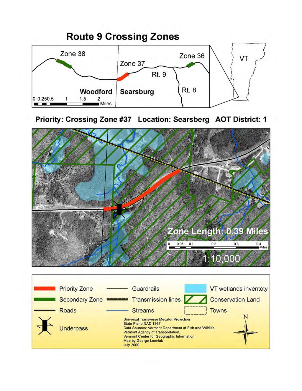
68
69 Anecdotal Reports VFWD Forest Hammond and the surveyor located this zone. The surveyor met with the local area game warden and VAOT representatives along this section of road, but the location was not indicated as a problem area or a location where animal vehicle collisions occur. No occurrences of animal/vehicle collisions were documented at this zone. Summary of Tracking Surveys Priority Crossing Zone 37 was surveyed on three occasions in the winter and three times in the spring. Winter and spring surveys indicated that river otter, mink, beaver used the large round culvert at the western portion of the zone, while gray fox, red fox, coyote, white-tailed deer, and showshoe hare crossed sections of the road in the eastern section of the zone. Physical Management Strategies Beavers had dammed the large culvert at the western end of the zone. The dam creates an 8 drop in to the culvert. The height of this dam may create a barrier to species movements towards the wetland. Mink and river otter tracks were observed moving down the dam and through the culvert, but not in the other direction toward the wetland. These species and others may have circumvented the culvert and move over the road to return to the wetland. This round culvert only facilitates the movement of aquatic and semi-aquatic species. This location may benefit from a culvert that could also facilitate the movements of terrestrial species. A multispecies underpass may be appropriate, because the slope is steep on either side of the road and guardrails are present on both sides of the road. The combination of the steep slope and guardrails may act as a barrier to the movement of some terrestrial species. An underpass that enhanced the movements of aquatic, semi-aquatic and terrestrial species is recommended for the western portion of this zone near the wetland. The eastern section of the zone has two small culverts, which have a drop of 4 feet on the northern side of the road. No species were observed using these culverts during the winter surveys, because their entrances were covered with snow. Wildlife may use these culverts during other seasons, and the height of the drops should be minimized to enhance the ability of wildlife to enter and exit the culverts. 72

70 The vegetation on the north side of the road is set far back from the roads edge towards the center of the zone. Creating thicker cover towards the roads edge with plantings of coniferous species may encourage species movements at this site, however motorists would need adequate warning of the crossing zone, because this section of road has a long sight distance. Motorists tend to increase speed in these situations, which may increase the potential for animal/vehicle collisions, so signs would need to warn drivers well in advance of the crossing zone. This zone is within a four mile section of road that is flanked by moose crossing signs, but additional signs should be posted when approaching this zone. Policy Overview This zone is located in the GMNF. There are wetlands located to the north and south of the crossing, and one house near the southern end of the zone. Searsburg does not have a town plan, zoning or subdivision regulations. Policy Recommendations Encourage acquisition of the in-holdings by the GMNF, to limit future subdivision. If development pressure increases, the town should consider adopting a town plan, zoning and subdivision regulations. The town plan and regulations should incorporate policies to maintain the ecological integrity and functions of the wildlife crossing. Photo 19. Line of sight from east to west 73


71 Photo 20. Line of sight from west to east Photo 21. Large Culvert VI. Conclusion Through Critical Paths, the project partners developed and tested a replicable methodology to prioritize important wildlife crossing zones and develop recommendations to reduce wildlife mortality and enhance road permeability for wildlife in Vermont. Recommended physical management strategies are, for the most part, reasonable and cost effective. In addition, policy recommendations can supplement physical adaptation strategies to ensure that the 74