Watershed Condition Framework
|
|
|
- Morris Chandler
- 5 years ago
- Views:
Transcription

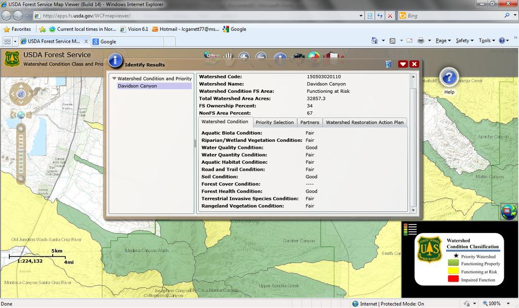
1 US Forest Service - Watershed Condition Classification Maps Page 1 of 2 1/9/2013 Watershed Condition Framework The Forest Service has released the first national Watershed Condition Framework and the accompanying Watershed Condition Classification Technical Guide. The Watershed Condition Framework establishes a new consistent, comparable, and credible process for improving the health of watersheds on national forests and grasslands. This framework will help focus our efforts in a consistent and accountable manner and facilitate new investments in watershed restoration that will provide economic and environmental benefits to local communities. The technical guide provided the protocol for the agency s first national assessment of watershed condition across all 193 million acres of National Forest System lands. Watershed Condition and Prioritization Interactive Map Website Watershed condition classification was completed on National Forest System lands in May of During the summer and fall of 2011, priority watersheds were identified and work began on Watershed Restoration Action Plans. Watershed Restoration Action Plans are programmatic documents in which the Forest Service describes existing resource conditions and identifies possible management actions that could be taken to move the Agency towards a desired future condition. If the Forest Service determines that it wants to move forward with any of these possible actions, the proposed actions will be subject to National Environmental Policy Act (NEPA) requirements at the time the projects are proposed. NEPA may have already been completed or may be underway on some of the projects described in the Action Plans. The results of the Forest Service Watershed Condition Framework planning work are available through a map viewer website where users can view the priority watersheds, read about why the watershed was selected, download the Watershed Restoration Action Plans and learn about other important planning items, including estimated costs and restoration partners. Each watershed on the map also contains information on the overall watershed condition rating and the individual rating of its 12 watershed condition indicators. The U.S. Forest Service s watershed condition classification, priority watershed designation and Watershed Restoration Action Plans are the first three steps in the agency s Watershed Condition Framework. This interactive mapping capability will better provide current and future partners important information on potential needs for watershed restoration and maintenance and will also increase the public s awareness of their local watershed conditions and the role they can play in improving them. The USDA Forest Service Watershed Condition and Prioritization Interactive map Interactive Mapping User Guide (PDF 1.6MB) Download a table containing the WCC and Prioritization information (HTML 7.25MB) For GIS Application download a shapefile with WCC and Prioritization information (ZIP 227MB) For GIS Application download an Excel spreadsheet with WCC attribute information (.xlsx 4.16 MB)
2 US Forest Service - Watershed Condition Classification Maps Page 2 of 2 1/9/2013 Watershed Condition Classification Maps The Watershed Condition Classification maps characterize the health and condition of National Forest System lands in the more than 15,000 watersheds across the country. These maps are the culmination of the first step in the agency s Watershed Condition Framework, instituted in 2011, and is the baseline condition that will be used along with information on ecological, social and economic factors and partnership opportunities to establish watershed restoration priorities. National Map (6.74mb PDF) Region 1 (3.86mb PDF) - Montana, Northern Idaho, North Dakota, Northwestern South Dakota and Northeast Washington. Region 2 (3.43mb PDF) - Colorado, Nebraska, Kansas and most of Wyoming and South Dakota. Region 3 (4.68mb PDF) - New Mexico and Arizona. Region 4 (5.81mb PDF) - Southern Idaho, Nevada, Utah and Western Wyoming. Region 5 (5.36mb PDF) - California. Region 6 (5.86mb PDF) - Washington and Oregon. Region 8 (3.20mb PDF) - Alabama, Arkansas, Florida, Georgia, Kentucky, Louisiana, Mississippi, North and South Carolina, Tennessee, Texas, Oklahoma, Virginia, and Puerto Rico. Region 9 (3.07mb PDF) - Maine, Illinois, Ohio, Michigan, Wisconsin, Minnesota, Iowa, Missouri, Indiana, Pennsylvania, West Virginia, Maryland, New York, Connecticut, Rhode Island, Massachusetts, Vermont, New Hampshire and New Jersey. Region 10 (3.71mb PDF) - Alaska.

3 USDA Forest Service Watershed Condition Classification - Region 3 Ratings based on assessments of National Forest System land in sixth-level watersheds MAY 12, 2011 Watershed Condition Classification Functioning Properly Miles Functioning at Risk Impaired Function
4
5
6
7
8