PART B. Policy Gaps to be Addressed in the Peel Region Official Plan Review (PROPR)
|
|
|
- Derick Skinner
- 5 years ago
- Views:
Transcription

1 PART B Policy Gaps to be Addressed in the Peel Region Official Plan Review (PROPR)
2
3 PART B Policy Gaps to be addressed in the Peel Region Official Plan Review (PROPR) 1.0 PURPOSE As discussed in Part A, the purpose of the (PROPR) is to identify policy and mapping gaps in the existing Official Plan in relation to recent Provincial policies and plans and updated mapping from various sources. Please note that this discussion paper includes preliminary recommended options to assist reviewers and provide clarity as to how policy options may be considered. The preliminary recommendations are presented to assist readers for discussion purposes only. The current policies in the Region of Peel Official Plan (ROP) are quite thorough and encompassing. The Plan itself is not very old, having been completed in 1997 and updated in However, with the changes to provincial policy, certain Regional policies are no longer relevant and gaps exist with respect to policy and mapping for some natural heritage features. The purpose of the policy review, therefore, is not to undertake a full scale review of the policy framework, but to identify revisions where these are needed to bring the Plan into conformity with provincial policy. As demonstrated through the review of provincial policies in Part A, these gaps are largely related to conformity with the Provincial Policy Statement (PPS) and with the Greenbelt Plan. In addition, changes are anticipated to the mapping of certain natural feature components of the Regional Greenlands System. Mapping updates to Schedule A for natural heritage features are being proposed in accordance with existing ROP policy where improved mapping data is available from various sources. When reviewing the mapping updates proposed in Part B, the term existing refers to Core features as currently mapped in the ROP on Schedule A. The term proposed refers to proposed mapping changes that are being considered through the PROPR policy review. Section 2 outlines proposed mapping updates as well as options for minor policy changes with respect to these features. The mapping update includes revisions to provincially significant wetlands, provincially significant life science s of Natural and Scientific Interest (ANSIs), Environmentally Significant s (ESAs), and Escarpment Natural s. These features are identified as Core s of the Greenlands System in section 2.3 of the Regional Official Plan. In addition to the mapping updates, a recommended approach for the mapping of Core Valley and Stream Corridors and a separate background technical study on significant woodlands and significant wildlife habitat have been prepared. A summary of these studies, their findings and the policy options to incorporate policy into the ROP are set out in Sections 3, 4 and 5 respectfully. Additional minor policy revisions to address conformity with the PPS are set out in Section 6, and Section 7 identifies policy options to address conformity with the natural heritage policy component of the Greenbelt Plan. 34
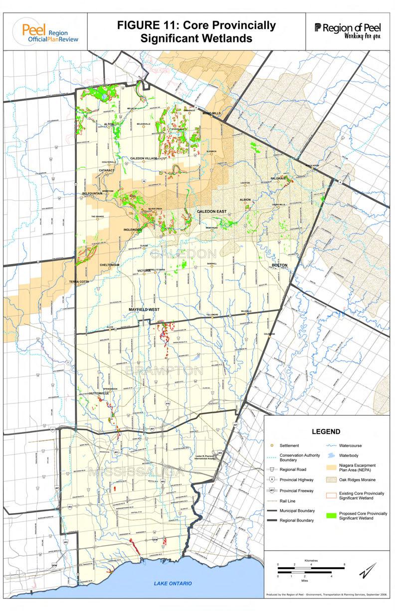
4 2.0 MAPPING UPDATES 2.1 WETLANDS Why are wetlands important? Wetlands control floods, protect coastal zones, provide for groundwater recharge or discharge, improve water quality and are host to a wide diversity of species of plants and wildlife. Wetlands also store carbon within their plan communities and soil instead of releasing it to the atmosphere as carbon dioxide. Wetlands are defined in the PPS as lands that are seasonally or permanently covered by shallow water, as well as lands where the water table is close to or at the surface. In either case, the presence of abundant water has caused the formation of hydric soils (soils in which there is an abundance of moisture) and has favoured the dominance of either hydrophytic or water tolerant plants. The four main categories of wetland are swamps, marshes, bogs and fens. Significant coastal wetlands were added as a new category of wetlands subject to protection under the 2005 PPS. The PPS defines significant wetlands and significant coastal wetlands as an area identified as provincially significant by the Ontario Ministry of Natural Resources in accordance with the Ontario Wetland Evaluation System (OWES). Coastal wetlands are defined in the PPS as any wetland that is located on Lake Ontario or is on a tributary to Lake Ontario and lies, either wholly or in part, downstream of a line located 2 kilometers upstream of the 1:100 year floodline of Lake Ontario. The PPS requires the protection of significant wetlands and prohibits development and site alteration within significant wetlands and significant coastal wetlands. Within the Protected Countryside of the Greenbelt Plan, wetlands are given a higher level of protection. For all wetlands in this Plan area, development and site alteration is not permitted with the exception of fish, forest and wildlife management; conservation and flood or erosion control projects; and infrastructure, aggregate extraction, passive recreational and existing uses subject to additional policies in the Greenbelt Plan (Section 4.0). Municipalities are permitted to be more restrictive than the PPS requirement, and some municipalities (e.g. Simcoe County) have opted to apply the higher standard in the Greenbelt Plan to other non-greenbelt areas Current Policy and Mapping The ROP currently recognizes and protects wetlands within the Greenlands System policies for Core s, Natural s And Corridors (NACs) and Potential Natural s and Corridors (PNACs). Core s incorporate provincially significant wetlands, whereas NACs incorporate wetlands of class 4 to 7 and PNACs incorporate unevaluated wetlands. Although the existing policies identify provincially significant wetlands, they currently do not list significant coastal wetlands. Rattray Marsh, in the City of Mississauga, is an example of a wetland that has been previously identified and protected as a provincially significant wetland and Core of the Greenlands System, but which is now considered a significant coastal wetland under the PPS. The ROP policies should be updated to reflect the new terminology and PPS policy for coastal wetlands. 35
5 The protection of provincially significant wetlands as Core s is still relevant, but the class system, which the ROP uses to identify NAC wetlands, is no longer used to rate wetlands. Accordingly, it is appropriate to consider replacing the class rating system with new terminology. The terminology could be evaluated, non-provincially significant wetlands as a component of NACs and unevaluated wetlands as a component of PNACs. A number of new wetland evaluations to identify provincially significant wetlands (PSW) have been completed since the ROP was adopted. Wetland mapping updates were included in ROPA 13 in 2005, but these did not include updates in the Town of Caledon. Table 4 indicates the areas of existing provincially significant wetlands in Peel Region by municipality. It also provides an indication of the amount of proposed provincially significant wetlands to be identified on Schedule A based on recent wetland evaluations and mapping provided by the Province. The proposed PSW wetland mapping is shown on Figure 11. There has been an increase in the amount of wetlands identified as provincially significant, with the vast majority of the wetlands occurring within the Town of Caledon. This is due to new or updated wetland evaluations by the Ministry of Natural Resources (MNR). The new or revised provincially significant wetland evaluations include: Hall Lake-Kenniflick Wetland Complex Town of Caledon (new) Castlederg Wetland Complex Town of Caledon (new) Hockley Valley Wetland Complex Town of Caledon (new) Campbell s Cross Wetland Complex Town of Caledon (new) Credit River-Alton Wetland Complex Town of Caledon (new) Widgett-Innis Lake Wetland Complex Town of Caledon (revised) Centreville Creek Wetland Complex Town of Caledon (revised) Credit Fork s Wetland Complex Town of Caledon (revised) Little Credit River Wetland Complex Town of Caledon (revised) Speersville Wetland Complex Town of Caledon (revised) Levi Creek Wetland Complex City of Brampton (revised) Churchville-Norval Wetland Complex City of Brampton (revised) In addition, wetlands within North-west Brampton; the Churchville-Norval Wetland Complex in the City of Brampton; and the Belfountain Wetland Complex and Caledon Mountain Wetland Complex in the Town of Caledon are undergoing evaluations and approval by the MNR. As such, these wetlands are not shown on Figure 11 or accounted for in Table 4. These wetland evaluations may be added to the PROPR mapping updates depending on when final wetland evaluations are approved by the MNR. Table 4: Core Provincially Significant Wetland Mapping in the ROP Total Peel Caledon Brampton Mississauga (ha) (ac) (ha) (ac) (ha) (ac) (ha) (ac) Existing Proposed
6
7 2.1.3 Recommended Policy Options for Wetlands The recommended policy options with respect to wetlands are to: Recommendation 1: Update the mapping for provincially significant wetlands; Recommendation 2: Update the terminology for wetlands as evaluated non-provincially significant wetlands in the Natural s and Corridors and unevaluated wetlands in the Potential Natural s and Corridors categories; and Recommendation 3: List significant coastal wetlands as Core s. 2.2 AREAS OF NATURAL AND SCIENTIFIC INTEREST (ANSIS) Why are ANSIs important? The PPS defines ANSIs as: areas of land and water containing natural landscapes or features that have been identified as having life science or earth science values related to protection, scientific study or education. Within the definition of an ANSI there are two main types: earth science ANSIs and life science ANSIs. Earth science ANSIs contain significant representative examples of bedrock, fossil and glacial landform features which are important to the scientific understanding of ongoing geologic processes. Life science ANSIs represent the Province s best natural heritage features and landscapes outside of provincial parks and conservation reserves. They are based on a regional (ecoregion) scale ecological analysis and framework. Life science ANSIs include specific types of forests, valleys, wetlands. The protection of life science ANSIs assists in preserving biodiversity at provincial, regional and local scales and protecting features representative of the Province s natural heritage. s of Natural and Scientific Interest are evaluated based on specific criteria and are identified as either provincially or regionally significant by the Ministry of Natural Resources. The Provincial Policy Statement requires that all significant ANSIs be protected with no development or site alteration permitted unless it has been demonstrated that there will be no negative impacts. For the purposes of the PPS, significant ANSIs include only those ANSIs that have been ranked as provincially significant Current Policy and Mapping The Region of Peel Official Plan definition of ANSI is similar to the PPS definition and is found within the Greenlands System policies as follows: areas of land and water containing natural landscapes or features of provincial significance having values related to natural heritage appreciation, scientific study or education. - Life Science s of Natural and Scientific Interest are those areas identified by the Ministry of Natural Resources for their high quality representation of important provincial biotic attributes. - Earth Science s of Natural and Scientific Interest are those areas identified by the Ministry of Natural Resources for their high quality representation of important provincial geological attributes. 37
8 ANSIs are incorporated into the Regional Greenlands system policies through the identification of provincial life science ANSIs as Core s and provincial earth science ANSIs as Potential Natural s and Corridors. This differentiation is appropriate from a natural heritage perspective considering the difference in ecological importance of the life science verses earth science ANSIs. However, the ROP policies do not list regionally significant ANSIs in the three Greenlands System categories. The ROP policies could be amended to list regional ANSIs in one of the three Greenlands System categories. Table 5 indicates the areas of existing provincially significant life science ANSIs in Peel Region by municipality. It also provides an indication of the total area of proposed life science ANSIs based on current mapping from the Province. These features are illustrated on Figure 12. There has been very little change in the amount of ANSIs identified as provincially significant, with a slight increase in the Town of Caledon and a slight decrease in the City of Mississauga due to mapping improvements. Table 5: Core Provincially Significant Life Science s of Natural And Scientific Interest (ANSIs) Total Peel Caledon Brampton Mississauga (ha) (ac) (ha) (ac) (ha) (ac) (ha) (ac) Existing N/A N/A Proposed N/A N/A Recommended Policy Options for ANSIs The recommended policy options with respect to ANSIs are: Recommendation 1: Update the mapping for provincially significant life science ANSIs. Recommendation 2: List regionally significant life science ANSIs as Natural s and Corridors. Recommendation 3: List regionally significant earth science ANSIs as Potential Natural s and Corridors. 2.3 ENVIRONMENTALLY SENSITIVE OR SIGNIFICANT AREAS (ESAS) Why are ESAs important? Environmentally Sensitive or Significant s are important because they provide a protected area for animals and/or plants that are limited, rare or unique within the Region. Ecosystem diversity is protected which enhances ecological integrity, protects the Region s natural heritage and potentially increases resilience of ecosystems to stresses, including development impacts. The Provincial Policy Statement does not provide a definition of the term ESA. In the Region of Peel Official Plan, the definition provided is as follows: 38
9
10 Environmentally Sensitive or Significant s: places where ecosystem functions or features warrant special protection. These may include but are not limited to rare or unique plant or animal populations or habitats, plant or animal communities, or concentrations of ecological functions. Environmentally Sensitive or Significant s are identified by the conservation authorities according to their established criteria. Although ESAs are not explicitly recognized in the PPS, most ESAs would be considered significant under the PPS as they may contain significant wildlife habitat, significant woodlands or wetlands and / or threatened and endangered species Current Policy and Mapping The Region of Peel includes ESAs in the Core s of Greenlands System and are thus accorded the highest level of protection. The criteria for identifying ESAs are based on evaluations completed by the conservation authorities. This process of identifying Environmentally Sensitive or Significant s as an environmental planning approach is being updated to include planning on a natural heritage systems basis where the focus is on protecting a linked natural heritage system rather than individual features or areas. As planning shifts to more formally adopt natural heritage system approaches, the role and purpose of ESA protection may change. This is discussed further in Part C of the discussion paper. Table 6 indicates the areas of existing ESAs in the Region by area municipality. It also provides an indication of the amount of proposed ESAs based on updated mapping from the conservation authorities. The features are illustrated on Figure 13. There has been a decrease of approximately 400 hectares in the amount of ESAs identified within the Credit River watershed with most of that decrease occurring in the Town of Caledon. This change arose due to improved mapping of the features using updated orthophotography by Credit Valley Conservation. Table 6: Core Environmentally Sensitive or Significant s (ESAs) Total Peel Caledon Brampton Mississauga (ha) (ac) (ha) (ac) (ha) (ac) (ha) (ac) Existing 8, , , , ,324.6 Proposed 7, , , , , Recommended Policy Options for ESAs The recommended option with respect to ESAs is to: Recommendation 1: Update the mapping for ESAs. 39
11
12 2.4 ESCARPMENT NATURAL AREAS Why are Escarpment Natural s important? The Niagara Escarpment is a provincially significant natural heritage feature that has been recognized nationally and internationally. The geological feature creates a unique ecology through the Escarpment area. The Niagara Escarpment Plan is protective of natural areas and controlling of development to regulate encroachment on the escarpment. The two key protective designations are Escarpment Natural s and Escarpment Protection s. Escarpment Natural s include escarpment slopes and related landforms in a relatively natural state, significant stream valleys, provincially significant wetlands, provincially significant life science ANSIs and forested lands within 300 metres of the Escarpment brow. These areas are designated Escarpment Natural because they contain the most significant natural and scenic areas of the Escarpment. This designation is the most restrictive NEP designation in terms of permitted development and land use. Permitted uses within Escarpment Natural s include existing uses, single dwellings, non-intensive recreational uses, home occupations, cottage industries, farm vacation homes, bed and breakfasts in existing dwellings, conservation activities, forest, fish and wildlife management, essential infrastructure and utilities. Escarpment Protection s include natural features that have been significantly modified by land use activities, that are considered of regional significance (e.g., regionally significant life science ANSIs and ESAs), or that are needed to buffer Escarpment Natural s. Escarpment Protection s are important for maintaining the open landscape character of Escarpment Features. The NEP policies encourage agriculture, forestry and recreation in these areas Current Policy and Mapping The Region of Peel Official Plan recognizes the NEP and supports the designations and policies of the NEP. Escarpment Natural s are included as a component of the Core s of the Greenlands System whereas Escarpment Protection s are included within the Natural s and Corridors component. Escarpment Natural s are identified in the Niagara Escarpment Plan which is updated from time-to-time by the Province. Table 7 indicates the area of existing Escarpment Natural s in Peel Region by local municipality. It also provides an indication of the total amount of proposed Escarpment Natural s based on updated mapping from the Province. These features are illustrated on Figure 14. There has been a slight decrease of approximately 30 hectares in the amount of Escarpment Natural s designated in the Niagara Escarpment Plan in Peel Region. As the Niagara Escarpment only occurs in the Town of Caledon, this change was limited to Caledon only. The original Escarpment Natural boundaries in the 1996 ROP were digitized from the official Niagara Escarpment Plan maps at the time (1994). Those maps were created at a scale of 1:50,000 and hence the boundaries of the Escarpment Natural s appear to be smoothed or generalized. The current Niagara Escarpment Plan designation boundaries were digitized at a scale of 1:10,000 in the late 1990s based on Ontario Base Maps and aerial photograph interpretation, which provides more detailed mapping of Escarpment Natural boundaries. The proposed mapping revisions represent only minor adjustments. 40
13
14 Table 7: Core Escarpment Natural s Total Peel Caledon Brampton Mississauga (ha) (ac) (ha) (ac) (ha) (ac) (ha) (ac) Existing 3, , , ,867.2 N/A N/A N/A N/A Proposed 3, , , ,794.9 N/A N/A N/A N/A Recommended Policy Options for Escarpment Natural s The recommended option with respect to Escarpment Natural s is to: Recommendation 1: Update the mapping for Escarpment Natural s. 41
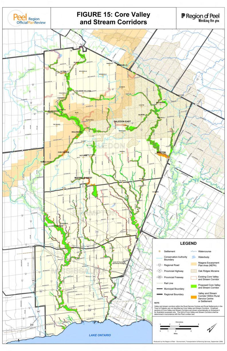
15 3.0 SIGNIFICANT VALLEYLANDS 3.1 WHY ARE VALLEYLANDS IMPORTANT? Valleylands contain essential ecosystems that contribute to the overall health and sustainability of the natural environment. Valleylands also offer important economic, recreational and social opportunities that contribute to the quality of life for communities. Providing essential ecological functions, valleylands contain a diversity of habitats and maintain biodiversity as linkages that facilitate the movement and dispersal of flora and fauna over long distances. In the Region of Peel, the major valley systems provide bioregional linkages connecting the Niagara Escarpment, the Oak Ridges Moraine and the Greenbelt to Lake Ontario and other natural features. In addition to their ecological functions, valleylands convey flood waters and contain areas that are subject to flooding and erosion or facilitate groundwater flow including groundwater recharge and discharge. In highly urbanized and fragmented landscapes, valleylands represent a significant portion of the remaining natural areas. Such features are important landforms that contribute to the character of a community and are areas that are highly valued for their recreational opportunities and cultural heritage. The PPS requires the protection of significant valleylands and permits no development or site alteration unless it has been demonstrated that there will be no negative impacts. The Region of Peel, the Cities of Brampton and Mississauga and the Town of Caledon must identify and protect significant valleylands in a manner that is consistent with the Provincial Policy Statement (PPS). The respective policies of the Regional and area municipal official plans guide the identification and protection of significant valleylands in accordance with the PPS. Significance is defined in the PPS to mean ecologically important in terms of features, functions, representation or amount, and contributing to the quality and diversity of an identifiable geographic area or natural heritage system. Core valleylands are considered significant by the Region of Peel at a regional scale and context and therefore represent a subset of the overall valley and stream corridor system in Peel. The area municipalities may identify additional valleylands that they determine are significant to the geographical area of that specific municipality. 3.2 CURRENT POLICY AND MAPPING Core valley and stream corridors are distinguished from locally significant valley and stream corridors in the ROP. Valley and stream corridors associated with the main branches of the Credit River, Etobicoke Creek, Mimico Creek, West Humber River, and Humber River are included within Core s in the ROP along with smaller watercourses draining directly into Lake Ontario. These valley and stream corridors have been identified for their regional significance recognizing their contributions in providing: important ecological functions that are regional in scale; habitat for endangered or threatened species; and linkages to other Core s of the Greenlands System. Natural s and Corridors include those valley and stream corridors that have a drainage area of 125 hectares or larger and which are not defined as part of the Core s. Potential Natural s and Corridors include those valley and stream corridors that have a drainage area of less than 125 hectares. 42
16 In 2005, the Region revised Schedule A to update the mapping of Core valley and stream corridors in the Cities of Brampton and Mississauga. Updates to the mapping in the Town of Caledon were intended to be completed at the time, but were deferred pending approval of Official Plan Amendments 124 and 161 for the Town of Caledon. Now that these policies for the Town of Caledon have been approved, it is proposed that refinement of Core valleylands mapping proceed through this current official plan review. As a component of this review, staff from the Region, the Town of Caledon and the Cities of Brampton and Mississauga have prepared a technical review of mapping criteria called Proposed Methodology to Update Mapping of Core Valley and Stream Corridors which is included as Appendix A to this discussion paper. 3.3 CORE VALLEY AND STREAM CORRIDOR CRITERIA The Proposed Methodology to Update Mapping of Core Valley and Stream Corridors sets out a proposed mapping methodology and criteria for regionally significant valleylands. The proposed methodology was developed with input from area municipal staff in order to refine Core valleyland mapping within the Town of Caledon and to include minor refinements in the Cities of Brampton and Mississauga to incorporate recent mapping data. The proposed methodology considers mapping criteria appropriate for identifying Core valleylands within the Urban System (Cities of Mississauga and Brampton) and Rural System (Town of Caledon) within Peel. These methodologies and criteria are summarized in Table 8. Table 8: Summary of Core Valley and Stream Corridor Mapping Methodology and Criteria Core Valley and Stream Corridor Mapping Criteria Component Main branches, major tributaries, other tributaries and identified watercourses draining directly to Lake Ontario Valley and stream corridors are the natural resources associated with the river systems characterized by their landform, features and functions, and include associated ravines. Main branches, major tributaries and watercourses having direct drainage to Lake Ontario are mapped from their outlet to the furthest upstream extent of their defined valley landform (i.e., mapped to limit of crest of slope) Other tributaries are included and mapped to the limit of their defined valley portion if they meet the following criteria: contains habitat of aquatic endangered or threatened species; or watercourse crosses municipal boundaries and provides linkage to other Core s of the Greenlands System. Excludes ill-defined headwater drainage features including created headwater valley/stream corridors, discontinuous defined valley features and other nonvalley landforms 43
17 Ill-defined sections of major valleys Ill-defined sections are illustrated using regulatory floodplain and meander belt hazards whichever is greater unless site specific assessment has determined valley width in accordance with text of Plan Shown schematically and subject to site specific evaluation to confirm width of Core Valley and Stream Corridor Associated Ravines Associated ravines within the Urban System are included if meeting one of the following criteria: important ecological functions related to the valley landform; habitat for endangered / threatened species; linkage to other natural features of the Greenlands System; flood and erosion hazards; and restoration potential. Associated ravines within the Rural System are not considered Regional Core valley and stream corridors. Significance determined in accordance with the Town of Caledon policies. Figures 15 and 16 apply the mapping methodology and criteria to illustrate the potential Core valley and stream corridors. Table 9 indicates the areas of existing Core valley and stream corridors in Peel Region. It also provides an indication of the proposed Core valley and stream corridors based on the revised methodology. Table 9: Core Valley and Stream Corridors Total Peel Caledon Brampton Mississauga (ha) (ac) (ha) (ac) (ha) (ac) (ha) (ac) Existing 7, , , , , , , ,964.1 Proposed 9, , , , , , , ,
18
19
20 3.4 POLICY OPTIONS AND PRELIMINARY RECOMMENDATIONS FOR CORE VALLEY AND STREAM CORRIDORS The policy options for Core valley and stream corridors are as follows: Option 1: Define Core valley and stream corridors as the main branches, major tributaries and other tributaries and watercourses meeting specified criteria as set out in Table 8; Include associated ravines within the Urban System as Core valley and stream corridors if they meet certain criteria as set out in Table 8 above; For ill-defined sections of the valleys use regulatory floodplain and meander belt hazards as the width of the corridor; and Continue to categorize all non-core valley and stream corridors into Natural s and Corridors and Potential Natural and Corridors based on the 125 ha drainage area minimum size threshold. Option 2: Define Core valley and stream corridors as the main branches, major tributaries and other tributaries and watercourses meeting specified criteria as set out in Table 8 above; Include associated ravines within the Urban System as Core valley and stream corridors if they meet certain criteria as set out in Table 8 above; For ill-defined sections of the valleys use regulatory floodplain and meander belt hazards as the width of the corridor; and Categorize all non-core valley and stream corridors as Natural s and Corridors, with no differentiation based on drainage area. Option 3: Continue to define Core valley and stream corridors in accordance with the existing policy of the ROP. The preliminary recommended option is Option 2 as the 125 ha drainage area threshold separating NAC and PNAC valley and stream corridors is no longer considered relevant for determining valley and stream corridor significance. Conservation authority staff advised that the criterion was used previously in technical guidance as a threshold to identify watercourses with flood and erosion hazard potential and is no longer relevant as a criterion for separating valley and stream corridors into NAC and PNAC categories. All valley and stream corridors that are not identified as Core valley and stream corridors are recommended to be identified as NACs which are subject to further interpretation, protection, management and stewardship in accordance with area municipal official plan policy. 3.5 QUESTIONS FOR THE PUBLIC Which of these options should be considered by the Region in updating its Official Plan? Are the proposed mapping criteria to identify major tributaries and other tributaries as Core valley and stream corridors appropriate? Should other criteria for the identification of Core valley and stream corridors be considered? 45
21 4.0 SIGNIFICANT WOODLANDS 4.1 WHY ARE WOODLANDS IMPORTANT? Woodlands perform a host of ecological functions that are important for the maintenance of a healthy environment. The woodland canopy shades the ground reducing air temperature and evaporation. Surface water run-off is reduced through interception of rainfall by the tree canopy and ground flora. By reducing the rate of evaporation and slowing surface run-off, more rain and snow can soak into the ground to replenish the groundwater, and the problems associated with rapid surface run-off (e.g., erosion and sedimentation) are reduced. This also assists in the maintenance of baseflow in watercourses; benefiting water quality, as well as fish and other aquatic life. Woodlands adjacent to watercourses also shade the water keeping it cooler, while insects and decomposing leaves provide a source of food for fish and aquatic organisms. The foliage also plays and important role in improving air quality. In particular, woodlands convert carbon dioxide to oxygen through the process of photosynthesis as well as trapping airborne particulate matter (e.g., carbon sequestration). Woodlands can also provide products with direct economic value. In addition to the timber, which can be harvested for a variety of uses, woodlands may also be used for maple sugar production and fuelwood. The flora associated with woodlands is distinct from that provided by open habitat, thus woodland preservation protects a large number of wildflowers and shrubs that would not otherwise occur. There are also many different types of woodlands, depending on soil type, moisture, slope, etc., each with a distinct composition of plants and animal species. As discussed in Section 2.9, woodlands also provide wildlife habitat, including habitat for rare, threatened and endangered species. Maintenance of a range of woodland types thus preserves biological diversity. Woodlands also provide aesthetic benefits and have value from a purely social and educational perspective. They provide respite from the urban environment and can provide a place for solitude and reflection. Prior to settlement, Peel was a predominantly wooded landscape, and the remnant woodlands provide a reminder of the environment that the first settlers in the Region encountered. Thus, woodland cover helps to define the character of communities and contributes to community identity. 4.2 CURRENT POLICY AND MAPPING The ROP includes woodlands within the Greenlands System and uses only a size criterion to determine whether the woodlands fall within the Core s, Natural s and Corridors (NAC) or Potential Natural s and Corridors categories. Core s include woodlands greater than 30 hectares in size, while NACs include woodlands of 3 to 30 hectares in size, and PNACs include all other woodlands less than 3 hectares in size. Core s are afforded protection in the ROP through policies that prohibit development and site alteration with some exceptions. Woodlands identified as NACs are to be evaluated, protected and restored in accordance with area municipal official plans while PNACs are subject to further evaluation to determine their significance and level of protection. Woodlands are defined in the Regional Plan as complex ecosystems comprising communities 46
22 of trees, shrubs, ground vegetation and the immediate biotic and abiotic environmental conditions on which they depend. Woodlands provide a range of ecosystem functions including: attenuating flood flows; trapping air and water borne sediment; preventing erosion and stabilizing steep slopes; providing shade for cold water fisheries; enhancing groundwater recharge areas; providing habitat; and promoting species diversity. Woodlands may also contain remnants of old growth forests. The Regional Plan does not identify the term significant woodland ; however, significance is determined in accordance with the policies for Core, NAC and PNAC categories. 4.3 SIGNIFICANT WOODLANDS STUDY The Peel-Caledon Significant Woodlands and Significant Wildlife Habitat Study (currently in draft) is the technical study undertaken to define significant woodlands in the Region of Peel and the Town of Caledon. This was accomplished by developing a suite of criteria and thresholds that identify those woodlands that should be considered significant. The study process first identified a number of other Towns, Cities, Counties and Regions, as well as government and non-government organizations that have undertaken studies on the significance of woodlands. From this review, a list of 18 candidate draft criteria was identified. These criteria were evaluated to assess their defensibility, ease of quantification, availability of accepted thresholds, availability of data and need for fieldwork. This evaluation was initially undertaken by the consultant team, and subsequently refined through consultation with a group of municipal staff, a technical advisory team, stakeholders and the public. The evaluation yielded six draft criteria that have been recommended to identify significant woodlands in the Region of Peel and the Town of Caledon. The draft report has been released to the public for comment and may be further refined following this circulation. It is important to note that significant woodlands are defined in the Oak Ridges Moraine Conservation Plan (ORMCP). Woodlands within the ORM plan area that satisfy the definition of significant woodland using the ORMCP must be considered significant. The Region or local municipalities can identify additional significant woodlands, but not fewer. Definition The Peel-Caledon Significant Woodlands and Significant Wildlife Habitat Study explored several alternative definitions of woodlands 11 for use outside of the ORM plan area. The definition of woodlands is intended to assist landowners, decision makers and those evaluating natural features to determine what natural features qualify as woodlands for the purpose of defining significance. It is important that the definition include the diversity of woodland communities and ages in Peel. Various definitions were considered and the following definition, meeting these requirements, is recommended in the Significant Woodland and Significant Wildlife Habitat Study Report (draft). It is based on the definition from the ORM Conservation plan, with some refinements that resulted from consultation with stakeholders: For the purpose of this report, a woodland will be defined as any area greater than 0.5 ha that has: (a) a tree crown cover of over 60% of the ground, determinable from aerial photography 12, or 11 As noted in the introduction, the terms forest and woodland are used synonymously in a general sense in this report unless otherwise noted. 12 forest of Lee etal
23 (b) a tree crown cover of over 25% of the ground ( savannah of Lee et al. 1998), determinable from aerial photography, together with on-ground stem estimates of at least: 1,000 trees of any size per hectare, or 750 trees measuring over five centimeters in diameter, per hectare, or 500 trees measuring over 12 centimeters in diameter, per hectare, or 250 trees measuring over 20 centimeters in diameter, per hectare (densities based on the Forestry Act of Ontario 1998) Treed portions with less than the required stocking level will be considered part of the woodland as long as the combination of all treed units in the overall connected treed area meets the required stocking level. Woodlands experiencing changes such as harvesting, blowdown or other tree mortality are still considered woodlands. Such changes are considered temporary whereby the forest still retains it long-term ecological value. And, which have a minimum average width of 40 metres or more measured to crown edges. As noted in Section 5.2 of the Peel - Caledon Significant Woodlands & Significant Wildlife Habitat Study, the clarifications and guidance for interpretation provided in the ORM Technical Paper #7 provide valuable guidance both on and off the Moraine. This includes guidance in defining patches, addressing interior gaps, and determining when plantations are included. It is recommended that the guidance provided in the ORMCP Technical Paper #7 for applying the woodlands definition should also be used in the Region of Peel and the Town of Caledon with respect to: how to address two or more wooded patches that are connected; interpreting gaps in wooded areas; how to treat indents in woodlands; when two wooded patches are so close as to be considered one patch; the exclusion of certain plantations; and the exclusion of communities dominated by non-native buckthorn or Norway maple. With respect to plantations, the following would be excluded from being significant (per the ORMCP Technical Paper 7): a plantation managed for production of fruits, nuts, Christmas trees or nursery stock; or a plantation managed for tree products with an average rotation of less than 20 years (e.g., hybrid willow or poplar); or a plantation established and continuously managed for the sole purpose of complete removal at rotation, as demonstrated with documentation acceptable to the planning authority or the Ministry of Natural Resources, without a forest restoration objective. The ORM definition and guidelines as articulated in ORM Technical Paper #7 would continue to apply as a minimum on the ORM. The recommendation to use the ORM definition off the Moraine provides a consistent single definition to be applied Region-wide for ease of application. 48
24 The formal definition of woodland recommended in this section is for the application of criteria and thresholds. Meeting the definition of woodlands, however, does not necessarily mean the feature is considered a significant woodland as set out in the PPS. The determination of significance at both the Regional and local level is to be established based on specific criteria and thresholds. The Peel-Caledon Significant Woodlands and Significant Wildlife Habitat Study considered a range of potential criteria and thresholds. Proposed Criteria from the Peel-Caledon Significant Woodlands and Significant Wildlife Habitat Study The recommended suite of criteria recommended in the Peel-Caledon Significant Woodlands and Significant Wildlife Habitat Study is as follows: Woodlands satisfying any one of the following criteria should be considered significant: 1. Woodlands of a minimum size. The study identified two options for establishing certain thresholds: Option 1: Recommendation based on Urban-Rural System Distinction Woodlands satisfying the following size criteria should be considered significant: i. Urban System (i.e., within the 2031 urban boundaries for the Cities of Brampton and Mississauga): all woodlands 4 ha and greater in size; ii. Rural System (i.e., comprises all of the Town of Caledon): all woodlands larger than 16 ha. Option 2: Recommendation based on Physiography/Historical Land Use Woodlands satisfying the following size criteria should be considered significant: i. s on and above (west of) the Niagara Escarpment: all woodlands greater than 16 ha in size; ii. Rural and Urban System below the Niagara Escarpment: all woodlands greater than 4 ha. 2. Woodlands, or inclusions in woodlands equal to or greater than 0.5 ha that are older than 90 years; 3. Any woodland equal to or greater than 0.5 ha identified as supporting a linkage function, as determined through a natural heritage study approved by the Region and/or Town; 4. Woodlands equal to or greater than 0.5 ha within 100 m of another significant natural feature; 5. Woodlands within 30 m of a watercourse, surface water feature or evaluated wetland; and 6. Woodlands that supports any of the following: i. any G1, G2, G3, S1, S2, or S3 plant or animal species, or community as designated by NHIC; or 49
25 ii. any species designated by COSEWIC or COSSARO as Threatened, Endangered, or of Special Concern. iii. The following forest communities: Dry-Fresh White Pine-Red Pine Coniferous Forest Type (FOC 1-2) Dry-Fresh White Pine-Oak Mixed Forest Type (FOM 2-1) Dry-Fresh White Pine-Sugar Maple Mixed Forest Type (FOM 2-2) Moist-Fresh Hemlock-Sugar Maple Mixed Forest Type (FOM 6-1) Dry-Fresh Red Oak Deciduous Forest Type (FOD 1-1) Dry-Fresh White Oak Deciduous Forest Type (FOD 1-2) Dry-Fresh Mixed Oak Deciduous Forest Type (FOD 1-4) Dry-Fresh Oak-Hickory Deciduous Forest (FOD 2-2) Dry-Fresh Hickory Deciduous Forest (FOD 2-3) Fresh Sugar Maple-Black Maple Deciduous Forest (FOD 6-2) Terms that are underscored are defined in the Peel-Caledon Significant Woodland and Significant Wildlife Study Report. Why the Threshold Change At present, the ROP includes only woodlands greater than 30 ha as Core s. The current technical study to identify significant woodlands in the Region has proposed six draft criteria for defining significance, including a criterion that addresses size thresholds. The recommended size thresholds include all woodlands greater than 4 ha in the Urban System 13, and woodlands greater than 16 ha in the Rural System 14 on and north of the Niagara Escarpment and the Oak Ridges Moraine with an option of 4 ha or 16 ha for the Rural System south of the Niagara Escarpment and Oak Ridges Moraine. This change in size thresholds reflects the results of the comprehensive investigation and analysis undertaken as part of the Peel - Caledon Significant Woodland and Significant Wildlife Habitat Study. It is also consistent with approaches taken elsewhere in southern Ontario. This analysis included quantification of the existing forest cover in the Region, a review of best practices in other Ontario municipalities and an examination of the ecological attributes of woodlands and extensive consultation with staff from the conservation authorities, area municipalities of Peel, MNR, Niagara Escarpment Commission (NEC), and various stakeholder groups with interests in Peel Region. Lower size thresholds for identification of significant woodlands may be appropriate when woodland cover is considered at a local municipal scale. Cultural Woodlands All woodlands in the Region of Peel have been subjected to some level of human management in the past. This extends back to before European settlement, when First Nations managed woodlands for game and other forest resources, as well as using openings for agriculture and settlement. Currently, most of the existing woodlands represent remnant patches that have recovered through natural succession processes after having been logged, grazed, or otherwise used for economic gain. Some woodlands are second or third growth woodlands that occur on land where the forest was completely removed at various points in time. These forests vary in composition and quality depending on the length of time that the forest has been reestablishing, the nature and duration of the land use while it was cleared, and the underlying environmental characteristics such as soil type, moisture, exposure, seed bank, etc., all of which influence natural succession processes and species composition. Some of these woodlands 13 Within the 2031 urban boundaries for the Cities of Brampton and Mississauga 14 Comprises all of the Town of Caledon 50
26 could have been established over 100 years ago and may be virtually indistinguishable from those that have never been completely cleared. Some woodlands have been recently planted or have naturally established on sites that have been highly disturbed. The provincial Ecological Land Classification (ELC) recognizes these as cultural woodlands or cultural savannahs, depending on the degree of canopy closure. Such woodlands may provide shading of watercourses, or occur adjacent to an existing mature woodland thus facilitating the development of additional interior conditions in the mature woodland, or be characterized by features and functions that would merit consideration of significant status. Additionally, cultural woodlands can contribute to the urban landscape by providing greenspace for aesthetic, recreational, cultural heritage and "green infrastructure" functions. Notwithstanding this, some cultural woodlands in designated urban areas that have established through natural succession processes on abandoned lands may be located in areas that may be more appropriately planned for urban uses. Cultural woodlands in designated urban areas should be assessed with consideration for the local context and sound natural heritage and planning principles to determine their significance as part of healthy and sustainable communities. Significant cultural woodlands (i.e., those meeting significance criteria) that have been included within a Natural Heritage System (and have thus been recognized as having ecological values and contributing to an ecological system as a landscape scale) should be protected. Cultural savannahs and cultural woodlands (as defined through ELC) may need to be evaluated on a site-by-site basis to evaluate their significance. 4.4 POLICY OPTIONS AND PRELIMINARY RECOMMENDATIONS FOR SIGNIFICANT WOODLANDS i) Definition of Woodlands: An appropriate definition of woodlands was determined as part of the Peel - Caledon Significant Woodland and Significant Wildlife Study as described under Section 4.3 above. Recommendation: Adopt in the ROP the definition as recommended by the Peel Caledon Significant Woodlands and Significant Wildlife Habitat Study. ii) Criteria and Thresholds for the ROP: Natural heritage features are categorized in the ROP as Core s, NACs and PNACs. The recommendations of the Peel - Caledon Significant Woodlands and Significant Wildlife Habitat Study therefore need to be considered in terms of how the ROP categorizes significant woodlands and divides the criteria and thresholds between the Core, NAC and PNAC categories. If categorized as Core s, the woodlands are considered to be significant from a Region of Peel context. Whereas NACs and PNACs are intended to be identified, protected, restored and enhanced through policies in the area municipal official plans having regard for the ROP and provincial policy. NAC and PNAC woodlands are intended to support and connect core areas and can be considered to be significant in the local municipal context. An appropriate level of protection will be determined in accordance with the area municipal official plans. a) Determination of Significance Patch Size: In addition to options on how to categorize significant woodlands as Core s, NACs or PNACs, there is also a need to consider different woodland patch size options as recommended 51
27 in the Significant Woodlands and Significant Wildlife Habitat Study. The following are identified as policy options for the ROP: Option 1: Provide for different patch size thresholds for Core s based on Urban-Rural System distinction: Within the Urban System, all woodlands 4 ha or greater in size are classified as Core s; Within the Urban System, all woodlands equal to and greater than 2 ha and less than 4 ha in size are classified as NACs; Within the Rural System, all woodlands 16 ha or greater in size are classified as Core s; Within the Rural System, all woodlands equal to and greater than 4 ha and less than 16 ha in size are classified as NACs; and All other woodlands greater than 0.5 ha are classified as PNACs. Option 2: Option 3: Provide for different size thresholds based on Physiography/Historical Land use: Lands on and above (west of) the Niagara Escarpment, all woodlands 16 ha and greater in size are classified as Core s; Lands on and above (west of) the Niagara Escarpment, all woodlands equal to and greater than 4 ha in size and less than 16 ha are classified as NACs; Within the Urban System and portions of the Rural System below the Niagara Escarpment and Oak Ridges Moraine, all woodlands 4 ha and greater in size are classified as Core s; Within the Urban System, all woodlands equal to and greater than 2 ha and less than 4 ha in size are classified as NACs; and All other woodlands greater than 0.5 ha are classified as PNACs. Continue to define Core, NAC and PNAC woodlands in accordance with the existing policies in the ROP: For all lands within the Region of Peel, all woodlands that are a minimum of 30 ha in area are classified as Core s; For all lands within the Region of Peel, all woodlands that are greater than 3 ha and less than 30 ha are classified as NACs; and For all lands within the Region of Peel, all other woodlands are classified as PNACs. b) Determination of Significance Age, Proximity, Linkage Function and Supporting Significant Species Function: Similar to options for patch size, minimum woodland threshold size options may be considered for the significant woodland criteria for age; proximity to other features; supporting linkage functions; and supporting significant species. Option 1: For Core woodlands, the minimum threshold size will be 0.5 ha. All other woodlands will be classified as PNACs. 52
28 Option 2: For Core woodlands, the minimum threshold size will be 4 ha. All woodlands less than 4 ha and equal to or greater than 0.5 ha will be classified as NACS. All other woodlands will be classified as PNACs. Option 3: In keeping with the ROP policies for NACs and PNACs as supporting and linking Core s, the linkage, proximity and surface water quality criteria will be considered as NACs and only age and significant species will be considered as Core s as follows: For Core woodlands, the minimum threshold size for the age and significant species criteria will be 4 ha; All woodlands meeting the age and significant species criteria and which are less than 4 ha and equal to or greater than 0.5 ha will be classified as NACs; All woodlands meeting the linkage, proximity and surface water quality criteria and which are equal to or greater than 0.5 ha will be classified as NACs; and All other woodlands greater than 0.5 ha will be classified as PNACs. Option 4: Continue to define Core, NAC and PNAC woodlands in accordance with the existing policies in the ROP without reference to criteria for age; proximity to other features; supporting linkage functions; and supporting significant species. iii) Addressing Cultural Woodlands and Cultural Savannahs For those woodlands identified as cultural woodlands or cultural savannahs using the Ecological Land Classification the following policy options were identified. Option 1: Consider these woodlands as significant based on the threshold and criteria considered above. Option 2: Classify all such woodlands as PNACs which would allow the significance to be based on a site-by-site investigation. Option 3: Do not consider such woodlands as significant. Option 4: Do not add policy for cultural woodlands and cultural savannahs to the ROP. Cultural woodlands and cultural savannahs will continue to be considered and defined in accordance with the Core, NAC and PNAC criteria in the ROP. The preliminary preferred option is Option 1 for the size criteria, Option 3 for the age, proximity, linkage, surface water and significant species criteria and Option 2 for cultural woodlands and savannahs. Table 10 illustrates the preliminary recommended option for establishing criteria and thresholds for the Core, NAC and PNAC woodland categories. Figures 17 and 18 illustrate the mapping of Core, NAC and PNAC woodlands when the preliminary recommended criteria and thresholds are applied. Table 11 indicates the area of existing Core woodlands mapped in the ROP and the total area of proposed Core woodlands based on the draft recommended criteria. 53
29
30
31 Discussion Paper Table 10: Recommended Criteria and Thresholds for the Identification of Core, NAC and PNAC Woodlands ROP Category Core Maintains Integrity of the System Size Age Linkage Proximity Surface Water Quality Any woodland =/> 4 ha and containing at least 0.5 ha of woodland that is older than 90 years Rural System: =/> 16 ha Urban System: =/> 4 ha Significant Species N/A N/A N/A Any woodland =/> 4 ha that supports any of the following: i. any G1, G2, 3, S1, S2 or S3 plant or animal species, or community as designated by NHIC; or ii any species designated by COSEWIC or COSSARO as Threatened, Endangered or of Special Concern; or NAC Supports Integrity of the System PNAC May Support Integrity of the System Rural System: =/> 4 ha up to 16 ha Urban System: =/> 2 ha up to 4 ha Cultural woodlands, cultural savannahs and all other woodlands > 0.5 ha Any woodland =/> 0.5 ha and less than 4 ha and containing at least 0.5 ha of woodland that is older than 90 years Any woodland =/> 0.5 ha identified as supporting a linkage function, as determined through a natural heritage study approved by the Region or appropriate area municipality Any woodland =/> 0.5 ha within 100 m of another significant feature Any woodland =/> 0.5 ha within 30 m of a watercourse, surface water features or evaluated wetland N/A N/A N/A N/A N/A iii. The following forest communities: FOD 1-2, FOM 2-1, FOM 2-2, FOC 1-2, FOD 1-3, FOD 1-4, FOD 2-2, FOD 2-3 or FOD 6-2 Any woodland =/> 0.5 ha up to 4 ha that supports any of the following: i. any G1, G2, 3, S1, S2 or S3 plant or animal species, or community as designated by NHIC; or ii any species designated by COSEWIC or COSSARO as Threatened, Endangered or of Special Concern; or iii. The following forest communities: FOD 1-2, FOM 2-1, FOM 2-2, FOC 1-2, FOD 1-3, FOD 1-4, FOD 2-2, FOD 2-3 or FOD
32 Table 11 - Preliminary Recommended Core Woodland s 15 Peel Caledon Brampton Mississauga (ha) (ac) (ha) (ac) (ha) (ac) (ha) (ac) Core Existing 12,136 29,988 11,296 27, , Core Proposed 17,947 44,349 15,675 38,734 1,202 2,971 1,070 2, QUESTIONS FOR THE PUBLIC Should the Region adopt all six criteria for the identification of Core woodlands? If the size criteria are chosen, which of the patch size options (patch size based on Rural/Urban System or patch size based on Physiography/Historical Land Use) should be considered by the Region in updating its Official Plan? Which of the minimum threshold size options for age, proximity, linkage function and supporting significant species function should be considered by the Region in updating its Official Plan? Are some of the criteria more relevant for the identification of locally significant woodlands by the area municipalities? Should the Region divide criteria and thresholds for significant woodlands among the Core, NAC and PNAC categories as recommended? 15 Criteria for identification and mapping of Core Woodlands has been applied to a woodlands base layer. Although every effort has been made to apply the proposed criteria and thresholds to the updated woodlands base layer mapping in as comprehensive a manner as possible, criteria and thresholds that would require field verification will not be fully captured in the calculation of total proposed Core woodland cover. The proposed mapping is considered the best possible representation of Core Woodlands using current best available data. 55
33 5.0 SIGNIFICANT WILDLIFE HABITAT 5.1 WHY IS WILDLIFE HABITAT IMPORTANT? Wildlife habitat is a total set of conditions required for wildlife to persist. Wildlife habitat varies among species because each species has unique requirements. These conditions include requirements for shelter, feeding and reproduction. As defined by the PPS, wildlife includes plants, animals and other organisms. Wildlife habitat can occur at a variety of scales, depending on the species. It can be as small as a burrow or as large as a forest. It can occur in a variety of habitats, and even in multiple countries (e.g. migratory landbird stopover areas). Wildlife habitat for a single species can also change with the seasons (e.g. woodland breeding pools in spring and adjacent deciduous forest the remainder of the year). Wildlife habitats are defined by the landform, soils, hydrology, vegetation communities, climatic conditions and predators and prey that are present. As these factors change in composition, condition or extent, so do the associated wildlife habitats. Vegetation communities provide the fundamental foundation for almost all wildlife habitats, although some species have adapted and use human built structures such as homes and bridges as habitat. The more varied and extensive wildlife habitats are in the landscape, the more varied and extensive are the wildlife species they support. 5.2 CURRENT POLICY AND MAPPING Although significant wildlife habitat is a key natural feature identified for protection in the PPS, the ROP does not include it in the Greenlands System except that some significant habitat is captured in other features already protected such as ANSIs, ESAs and the habitat of threatened and endangered species. 5.3 SIGNIFICANT WILDLIFE HABITAT STUDY The Peel Caledon Significant Woodlands and Significant Wildlife Habitat Study recommends adoption of the definition for wildlife habitat contained in the Province s Signficant Wildlife Habitat Technial Guide which is identical to the definition in the 2005 PPS. According to the PPS, wildlife habitat is identified as: areas where plants, animals, and other organisms live, and find adequate amounts of food, water, shelter, and space needed to sustain their populations. Specific wildlife habitats of concern may include areas where species concentrate at a vulnerable point in their annual or life cycle; and areas which are important to migratory or nonmigratory species. The significant wildlife habitat portion of the Peel Caledon Significant Woodlands and Significant Wildlife Habitat Study identified a lengthy list of Significant Wildlife Habitat (SWH) criteria potentially applicable to the Region of Peel and Town of Caledon. In total, forty-one criteria were selected for assessment. These criteria were largely based on the information contained within the Significant Wildlife Habitat Technical Guide (SWHTG) (OMNR 2000) and Oak Ridges Moraine Conservation Plan Technical Paper 2 (ORMCP TP2) (OMNR 2007). The criteria were grouped according to the following four categories as per the SWHTG. Category A Seasonal Concentration s Category B Rare Vegetation Communities or Specialized Habitats for Wildlife 56
34 Category C Habitats for Species of Conservation Concern Category D Animal Movement Corridors Next, all available information on each of the 41 potential SWH criteria was assembled and reviewed. Where possible, thresholds appropriate to the Region of Peel and, where warranted, the Town of Caledon, were identified. Sources of information included the SWHTG and ORMCP TP2, as well as data from various governmental agencies (e.g. OMNR, Conservation Authorities), non-governmental agencies (e.g. Bird Studies Canada, Ontario Mammal Atlas) and other scientific and technical sources. Consultations were also undertaken with various agency experts throughout the study (e.g., OMNR, TRCA, CVC and NHIC). OMNR was consulted several times to ensure that recommended criteria and thresholds were consistent with SWH guidelines currently under development for Site Regions 6E and 7E. Based on this review, each of the criteria received one of the following three recommendations: Criteria recommended with a threshold; Criteria recommended without a threshold; Not recommended (i.e., inappropriate for the jurisdiction). A detailed description of each criterion was provided, along with a rationale for proposed thresholds or an explanation of why thresholds were not provided. Table 12, lists all 41 criteria assessed and their associated recommendation. Recommendations apply equally to the Town of Caledon and the Region of Peel unless specified otherwise. Details of the recommended thresholds are provided in the draft study report available through contacting the Region of Peel Planning Department. Table 12 - Summary of recommendations related to the candidate criteria for significant wildlife habitat SIGNIFICANT WILDLIFE HABITAT (SWH) CRITERIA recommended with a threshold recommended without a threshold not recommended A1. Deer wintering area A2. Colonial bird nesting sites (e.g., heronry, gull colony) A3. Waterfowl nesting habitat A4i. Migratory Landbird Stopover s Region of Peel 57
35 SIGNIFICANT WILDLIFE HABITAT (SWH) CRITERIA recommended with a threshold recommended without a threshold not recommended A4i. Migratory Landbird Stopover s Town of Caledon A4ii. Migratory Bat Stopover s A4iii. Migratory Butterfly Stopover s Region of Peel A4iii. Migratory Butterfly Stopover s Town of Caledon A4iv. Migratory Waterfowl Stopover and/or Staging (Terrestrial) A4v. Migratory Waterfowl Stopover and/or Staging (Aquatic) A4vi. Migratory Shorebird Stopover s A5. Raptor wintering areas (i.e., used for feeding and/or roosting) A6. Snake hibernacula A7. Bat maternal roosts and hibernacula A8. Bullfrog concentration areas (see details under B8ii) A9. Wild Turkey winter range A10. Turkey Vulture summer roosting areas B1. Rare vegetation communities B2. Forests providing a high diversity of habitats (captured by significant woodlands) B3. Old-growth or mature forest stands (captured by significant woodlands) B4. Foraging areas with abundant mast (i.e., nut bearing trees) B5. Highly diverse areas B6. Cliffs and caves B7. Seeps and springs B8i. Amphibian breeding habitat - Forested sites (e.g., vernal pools) 58
36 SIGNIFICANT WILDLIFE HABITAT (SWH) CRITERIA recommended with a threshold recommended without a threshold not recommended B8ii. Amphibian breeding habitat - Non-forested sites (e.g., marshes) B9. Turtle nesting habitat and turtle overwintering areas B10. Habitat for area-sensitive forest interior breeding bird species B11. Habitat for open country and early successional breeding bird species B12. Habitat for wetland breeding bird species B13i. Raptor nesting habitat - wetlands, ponds, and rivers B13ii. Raptor nesting habitat - woodland habitats B14. Mink, River Otter, Marten, and Fisher denning sites B15. Mineral licks C1. Species identified as nationally Endangered or Threatened by COSEWIC which are not protected in regulation under Ontario s Endangered Species Act. C2. Species identified as Special Concern based on Species at Risk in Ontario List that is periodically updated by OMNR. C3. Species that are listed as rare (S1 S3) or historical in Ontario based on records kept by the Natural Heritage Information Centre in Peterborough. C4. Species whose populations appear to be experiencing substantial declines in Ontario. C5. Species that have a high percentage of their global population in Ontario and are rare or uncommon in the Regional Municipality of Peel / Town of Caledon. C6. Species that are rare within the Regional Municipality of Peel/Town of Caledon, even though they may not be provincially rare (? Plant list is available; may be able to develop a preliminary list for wildlife from conservation authority data as part of this study) 59
37 SIGNIFICANT WILDLIFE HABITAT (SWH) CRITERIA recommended with a threshold recommended without a threshold not recommended C7. Species that are subjects of recovery programs. C8. Species considered important to the Regional Municipality of Peel / Town of Caledon, based on recommendations from a local Conservation Advisory Committee. D. Animal movement corridors 60
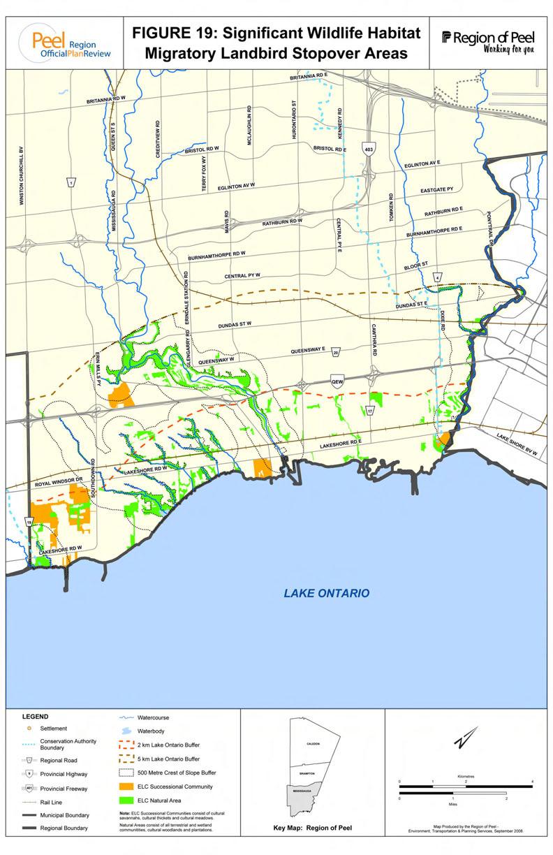
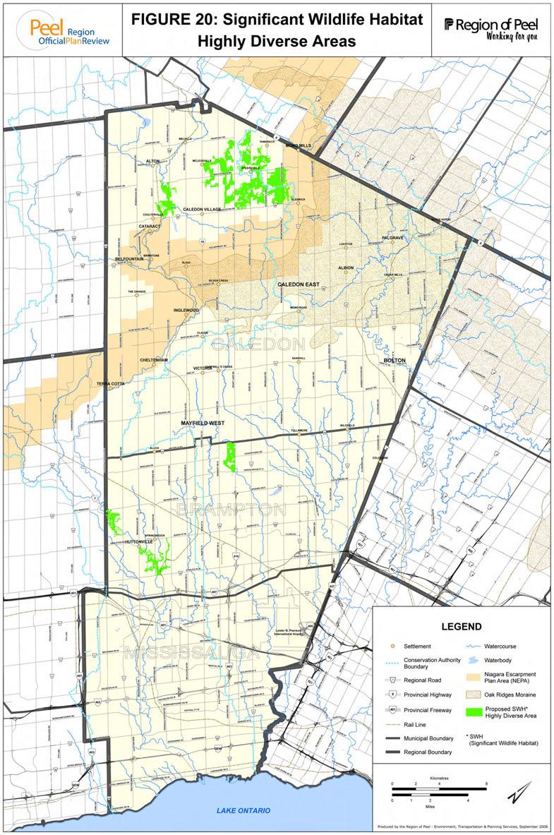
38 5.4 SIGNIFICANT WILDLIFE HABITAT STUDY- MAPPING The Study Report concluded that it would be impossible to produce comprehensive SWH mapping on a Region-wide basis for the majority of criteria being considered. Most SWH criteria cannot be mapped at a Region-wide scale since the information required is currently unavailable and needs to be gathered through site-specific investigations triggered by development proposals or other proposed land use changes. Other data on rare species (e.g. Species at Risk ) are sensitive and cannot be disclosed for security reasons. Although most SWH criteria are not possible to map, it has been possible to map two of the potential SWH criteria: Migratory Landbird Stopover s and Highly Diverse s. The MNR has also indicated an interest in providing mapping of deer wintering areas to the Region in the future. Migratory Landbird Stopover s Landbird is a term used to describe a general grouping of North American birds that live largely or entirely on land. This grouping includes all of the families of songbirds in North America. Stopover areas are areas where migrating landbirds stop to rest, forage and wait for favourable migration conditions. Habitat close to large lakes, such as Lake Ontario, is more important to stopover migrants since they are more likely to be making landfall after a potentially exhausting flight over water, especially if they have already traveled a large distance. Further detail on the rationale and criteria for Migratory Landbird Stopover s is set out in the Peel Caledon Significant Woodlands and Significant Wildlife Habitat Study. The areas of land that would meet the proposed criteria for Migratory Landbird Stopover s is documented in Table 13. Figure 19 graphically illustrates the areas meeting the proposed criteria. Table 13: Migratory Landbird Stopover s Proximity to Lake Ontario Terrestrial Natural s Wetland Natural s Successional Communities * (ha) (ac) (ha) (ac) (ha) (ac) Immediately on Lake Ontario* N/A N/A N/A N/A Within 2km 3, Within 5 km in river valleys , N/A N/A Within 5 km and within 500 m of river valleys*** , Note: * Successional Communities include ELC cultural savannahs, cultural thickets and cultural meadows. ** Immediately on Lake Ontario applies to Successional Woodlands Greater than 5 ha. Other successional community categories include areas greater than 10 ha. *** Within 5 km of Lake Ontario and within 500 m of river valleys does not include the river valley features within 5 km of Lake Ontario. Highly Diverse s Highly diverse areas are areas with a potential for a diversity of communities and species. Diversity was determined by the number of Ecological Land Classification (ELC) community types (at the Community Series level) per habitat patch. Habitat patches were defined as continuous natural areas (i.e., all woodland, wetland, and successional communities) not 61
39
40 separated by arterial or collector roads or built-up areas by more than 20 metre gaps. Successional communities included thicket and savannahs but not cultural meadows. The Peel Caledon Significant Woodlands and Significant Wildlife Habitat Study identified the top 5% most diverse habitat patches separately in (a) the Rural System and (b) the Urban System portions of the Region. The amount of land that would meet the proposed criteria is documented in Table 14. Figure 20 graphically illustrates the highly diverse areas meeting the proposed criteria. Table 14: Highly Diverse s Total Peel Caledon Brampton Mississauga (ha) (ac) (ha) (ac) (ha) (ac) (ha) (ac) Urban System , Rural System 1, , , , Total 2, , , , POLICY OPTIONS AND PRELIMINARY RECOMMENDATIONS FOR SIGNIFICANT WILDLIFE HABITAT i) Definition of Significant Wildlife Habitat: Recommendation: Adopt in the ROP the definition as recommended by the Peel Caledon Significant Woodlands and Significant Wildlife Habitat Study. ii) Criteria and Thresholds for the ROP: Option 1: List significant wildlife habitat as a Core and include policy to identify significant wildlife habitat in accordance with the criteria and thresholds recommended in the Peel-Caledon Signficant Woodlands and Signficant Wildlife Habitat Study. This option would include all the criteria from the Peel - Caledon Significant Woodlands and Significant Wildlife Habitat Study in the Official Plan as Core, and where sufficient geographic data is available, such as for highly diverse areas, this data would be added to the mapping of Core s in the ROP. Option 2: Option 3: List significant wildlife habitat as a Core but place the criteria and thresholds in an appendix. This option would include significant wildlife habitat in the Core of the Greenlands, but the criteria and thresholds for the identification of Core significant wildlife habitat would be included in an appendix as information to be applied on an application basis, and the habitat would not be mapped in the ROP. List significant wildlife habitat as a Core without reference to the study criteria and thresholds. 62
41
42 Option 4: Option 5: List significant wildlife habitat as a NAC and direct the area municipalities to use the criteria as study requirements. With this option, significant wildlife habitat would be included in the NAC component of the Greenlands System and the criteria and thresholds would be included in an appendix of the ROP as study requirements for municipalities or applicants (e.g. when completing environmental impact studies (EIS)) in determining areas of significant wildlife habitat. Existing thresholds will be applied or refined, and new thresholds provided for criteria that currently have none, through those studies. List significant wildlife habitat as a NAC without reference to the study criteria and thresholds. Option 4 is the preliminary recommended option due to the need for detailed site level analysis to determine areas of significant wildlife habitat. Option 4 provides greater certainty and guidance for applicants as recommended criteria and thresholds are provided for conformity with the PPS. It further provides reference to criteria and thresholds that have been refined and recommended based on a Regional analysis of significant wildlife habitat. 5.6 QUESTIONS FOR THE PUBLIC Which of the options should be considered by the Region in updating its Official Plan? 63
43 6.0 OTHER POLICY GAPS RELATED TO THE PPS The following analysis explores gaps in the implementation of the Provincial Policy Statement (PPS) This analysis focuses on policies and mapping for specific features identified in the PPS. 6.1 FEATURES PROTECTED The PPS requires protection of specific features. These specific features include: significant wetlands; fish habitat; significant woodlands; significant valleylands; significant habitat of endangered species and threatened species; significant wildlife habitat; and areas of natural and scientific interest. 6.2 PERMITTED USES The PPS has two categories of protection. In certain features, a very high standard of protection is required and no development or site alteration is permitted. This includes significant habitat of endangered species and threatened species, significant wetlands (in Ecoregions 5E, 6E and 7E, which includes the Region of Peel) and significant coastal wetlands. As well, no development or site alteration is permitted in fish habitat except in accordance with provincial and federal requirements. In other features, such as significant woodlands, valleylands, wildlife habitat and ANSIs development and site alteration are not permitted unless it is demonstrated that there will be no negative impacts on the natural features or their ecological functions. Further clarification is provided in the PPS that the natural heritage policies are not intended to limit the ability of existing agricultural uses in accordance with normal farm practices to continue. This provides certainty that existing agricultural uses will continue without being subject to the natural heritage policies of the PPS. 6.3 CURRENT POLICY The Core s of the ROP include habitats of vulnerable, threatened and endangered species, whereas the PPS no development and site alteration policy only requires protection of habitat of threatened and endangered species. Under the PPS, vulnerable species (now referred to as special concern species ) are addressed through the protection of species of conservation concern under significant wildlife habitat. Within the Core s of the ROP, development and site alteration is prohibited except for development permitted in floodplains, and for servicing, conservation, recreation and minor development and minor site alterations. Minor development is defined as development, which due to its scale or intensity, can demonstrate no significant incremental or cumulative impacts on the landform, features or ecological functions of the Greenlands System in Peel, as set out in further detail in the area municipal official plan. 64
44 Site alteration is defined as site grading, excavation or removal of top soil, vegetated cover and peat and the placing or dumping of fill. Minor site alteration is not defined. Permitting minor development or minor site alterations in provincially significant wetlands or within the habitats of threatened and endangered species would not conform with the PPS. As well, reference to no significant impacts in the definition of minor development may not conform with the PPS reference to no negative impacts, which would be a more strenuous test. The PPS also contains policies on adjacent lands and states that development is not permitted unless it is demonstrated that there is no negative impacts on the natural feature or its ecological function. Adjacent lands are defined in the PPS as those lands contiguous to a specific natural heritage feature or area where it is likely that development or site alteration would have a negative impact on the feature or area. The ROP only addresses study requirements for development and site alterations of new and expanded mineral aggregate extraction sites on adjacent lands. The ROP will need to be updated to address the new PPS policy for development and site alteration on adjacent lands. As well the definition of adjacent lands in the ROP should be updated to reflect the PPS definition. Lastly, although the ROP contains policy allowing established agricultural activities on adjacent lands without an environmental impact study, the current policy predates the PPS exemption for agriculture which applies to existing agricultural uses in accordance with normal farm practices on adjacent lands as well as within features. For example, existing crop production on a field that also happens to provide significant stopover habitat for waterfowl is permitted to continue without being subject to the PPS no development and site alteration policy. In order to clarify the exemption for existing agricultural uses in the ROP, it is recommended that the current policy wording be updated to be consistent with the PPS direction. This recommendation responds to stakeholder comments received during consultation on the Peel-Caledon Significant Woodlands and Significant Wildlife Habitat Study that new policy and criteria for significant woodlands and significant wildlife habitat should not prevent existing agricultural uses from continuing. 6.4 PRELIMINARY RECOMMENDED POLICY OPTIONS The following minor policy changes would ensure conformity with the PPS. The changes include: Recommendation 1: Revise the policies for minor development and minor site alteration so that no development or site alteration is permitted in significant wetlands, significant coastal wetlands and the habitat of threatened and endangered species; Recommendation 2: Change the definition of minor development from no significant impacts to no negative impacts; Recommendation 3: Change the reference to vulnerable, threatened and endangered species to threatened species and endangered species. Recommendation 4: Revise the policies to prohibit development and site alteration on adjacent lands to natural heritage features and areas unless it is demonstrated that there will be no negative impacts on features or functions. Recommendation 5: Update the definition of adjacent lands to reflect the PPS definition. Recommendation 6: Revise the ROP to clarify that the Greenlands System s no development and site alteration policies do not apply to existing agricultural uses in accordance with normal farm practices consistent with the policy wording in the PPS. 65
45 7.0 POLICY GAPS RELATED TO GREENBELT PLAN CONFORMITY 7.1 THE GREENBELT PLAN IN PEEL The policy framework of the Greenbelt Plan is summarized in Part A, Section 3.4. The Greenbelt Plan, including the area identified as Natural Heritage System, is delineated on Figure 9, the majority of which lies within the Town of Caledon with a small portion, extending into the City of Brampton. 7.2 EXAMPLES OF OTHER MUNICIPAL GREENBELT CONFORMITY The Greenbelt Act 2005 requires municipalities to amend their official plans to conform to the Greenbelt Plan. Municipal official plans are to contain policies that reflect the requirements of the Greenbelt Plan as well as mapping to reflect the Protected Countryside and Natural Heritage System. The following contains a best practice review of what other regional municipalities have undertaken to conform with the Greenbelt Plan. At this time, it appears that many Regional municipalities are currently undergoing the Greenbelt Plan conformity exercise. In terms of their approach, some have had an opportunity to define their work plan whereas others are initiating the process Regional Municipality of York The Region of York put forward a work plan to the Regional Council in January 2008 regarding the Greenbelt Plan conformity. The work plan indicates that conformity work has been built into the overall growth management work program that has been underway. The Region is intending to extend the approach already established for the Oak Ridges Moraine Conservation Plan to lands outside the moraine, but within the Greenbelt. In terms of the inventory of key natural features and key hydrologic features, York feels that there has been a thorough and comprehensive inventory maintained to date by the Region and its area municipalities that is in keeping with the requirements of the Greenbelt Plan. It is estimated that approximately 69% of York Region is subject to the various policies for the Greenbelt Plan s Protected Countryside designation. The revisions to the Regional Plan include: Deleting multiple lots for residential dwellings as a permitted use in the rural area; Changing from the use of CLI to classify agricultural land to the LEAR (Land Evaluation and Review) system in line with the Province; Refinement of other policies regarding expansion into the greenbelt area; Proceeding with the Natural Heritage System update which will begin in 2008 and will incorporate the identified Greenbelt Natural Heritage System; Finalize the mapping of wellhead protection areas and vulnerable areas; Mapping revisions in line with the work program. The Region of York has some of the work underway at this time with the remainder to be completed by Regional Municipality of Durham The Region of Durham was at the end of a long Official Plan review process when the Greenbelt Plan was released in Rather than finishing the Official Plan review, it was 66
46 decided to put the review on hold so that the Greenbelt Plan could be incorporated into the policies. The result is OPA 114 adopted by Regional Council September 13, Since then there have been appeals to the Ontario Municipal Board of OPA 114, primarily to the land use policies and/or mapping. There has also been one appeal to the Natural Heritage policies, which was approved by the Ontario Municipal Board in January The natural heritage policies are now in force. The policies of the Plan reflect very closely the policies of the Greenbelt Plan with respect to the Natural Heritage System and the protection and delineation of key natural heritage features and key hydrologic features. The Natural Heritage System is incorporated as a designation in the Official Plan as part of the Major Open Space s designation, which applies in and outside the Greenbelt Plan. Key natural heritage features and key hydrologic features are also mapped on a separate schedule, but the region has applied the same criteria for identifying these features in and outside the Greenbelt Plan. As well, these features are to be shown in more detail in area municipal official plans Regional Municipality of Niagara Niagara Region has recently implemented new environmental policies into the Regional Policy Plan. Amendment 187 was originally adopted by Regional Council late in 2005, and approved by the Ontario Municipal Board in the spring of The amendment brings the environmental policies of the Regional Policy Plan into conformity with the Provincial Policy Statement and the Greenbelt Plan. The policies identify a Core Natural Heritage System consisting of an Environmental Protection designation and an Environmental Conservation designation. In addition, Potential Natural Heritage Corridors are also designated. The Region s Core Natural Heritage System map also delineates the Greenbelt Natural Heritage System and the Niagara Escarpment. Key natural heritage features and key hydrologic features are not specifically delineated on the map. However, the features that comprise these categories are largely captured by the Environmental Protection designation and the Environmental Conservation designation. 7.3 PERMITTED USES IN THE GREENBELT PLAN NATURAL HERITAGE SYSTEM The Natural Heritage System of the Greenbelt Plan is illustrated in the Greenbelt Plan as an overlay on the Protected Countryside designation. The Natural Heritage System has been identified to include areas of the Protected Countryside with the highest concentration of the most sensitive and/or significant natural features and functions. The intent of the Greenbelt Plan is to manage the area as an integrated and connected natural heritage system. The full range of existing and new agricultural uses, agricultural-related uses, secondary uses and normal farm practices permitted within the Protected Countryside are not subject to the Natural Heritage System, but are subject to the environmental feature policies of the Greenbelt Plan. Non-agricultural uses that are permitted in the Protected Countryside are subject to the Natural Heritage System policies, which set out additional requirements for connectivity between natural features and restrictions on building coverage, the proportion of the site that can be disturbed, impervious area and area that is to remain in self-sustaining vegetation. The Greenbelt Plan requires municipalities to amend their official plans to show the boundaries of the Natural Heritage System and policies that reflect the requirements of the Greenbelt Plan. 67
47 7.4 KEY NATURAL HERITAGE FEATURES AND KEY HYDROLOGIC FEATURES POLICIES In addition to the requirement to identify and include policies for the Natural Heritage System overlay, the Ministry of Municipal Affairs is requiring that municipalities amend their Official Plans to include policies for key natural heritage features (KNHFs) and key hydrologic features (KHFs). Within features identified as KNHFs and KHFs that are located within the Natural Heritage System, including any associated vegetation protection zones, development or site alteration is not permitted except for forest, fish and wildlife management, conservation and flood or erosion control, infrastructure, aggregates, passive recreational, agricultural, shoreline and existing uses. A minimum width of 30 metres is required as a vegetation protection zone surrounding most KNHFs and KHFs to protect the features and their functions from the impacts of proposed development and, where possible, to restore or enhance the features or functions. In addition, studies are required for development within 120 metres of a KHF or a KNHF located in the Natural Heritage System. Those studies are to determine if the vegetation projection zone is of sufficient width to protect the features and their functions. Recreational uses permitted in a KNHF and KHF are limited to small-scale structures such as boardwalks, footbridges, fences, docks and picnic facilities provided the negative impacts on these features is minimized. This scale of recreational use would fit under the permission for passive recreational uses in the ROP. No new mineral aggregate extraction is permitted in significant wetlands, significant habitat of endangered and threatened species or significant woodlands unless the woodland is occupied by young plantation or early successional habitat. Aggregate extraction is permitted in other KNHFs and KHFs subject to specific provisions set out in Section of the Greenbelt Plan. The ROP may need to reflect the provisions for aggregate resources permitted in the other key natural heritage features and key hydrologic features. Existing Uses are permitted within the Greenbelt Plan including within key natural heritage features and key hydrologic features. Expansions to such uses within these natural features, including agricultural buildings and structures must demonstrate that there is no alternative to the expansion and impacts on the features and its functions are minimized to the maximum extent possible. This will need to be addressed in the ROP. Section 5.3 of the Greenbelt Plan permits municipalities to adopt policies that are more restrictive than the requirements of the Plan, unless in doing so the policies conflict with the objectives of the Greenbelt Plan. Under this policy, the Region has the option of applying the Greenlands System policies for Core s, NACs and PNACs within the NHS of the Greenbelt Plan in addition to the policies of the Greenbelt Plan. This is similar to the approach taken for the ORMCP, where the ROP states that where key natural heritage features and hydrologically sensitive features coincide with components of the Greenlands System, the policies of the Greenlands System will also apply (ROP, Section ). For most KNHFs and KHFs, the Greenbelt Plan criteria will be more restrictive with the exception of Environmentally Sensitive or Significant s, which are not a listed KNHF in the Greenbelt Plan and for some of the criteria for significant woodlands if the criteria for Core woodlands proposed in Part B, Section 4.0 of the discussion paper are adopted. Policies for KNHFs and KHFs will need to be reviewed with the Province and may need to be incorporated into the ROP. Currently, not all of the features listed as KNHFs and KHFs would 68
48 be considered Core s under the current policies of the ROP. If the KNHFs and KHFs are incorporated into the ROP Greenlands System framework, policy permissions and exemptions will need to be reviewed and harmonized as appropriate. 7.5 CRITERIA FOR IDENTIFICATION OF KNHFS AND KHFS On September 19, 2008, the Ministry of Natural Resources released three proposed technical papers providing criteria to assist municipalities in identifying KNHFs and KHFs listed in Section of the Greenbelt Plan. The proposed criteria have been released for public review and comment. The criteria are draft at this stage and comments will be considered by MNR as part of the decision making process to finalize the technical papers. Draft technical criteria are outlined for the following KNHFs: fish habitat; wetlands life science areas of natural and scientific interest; significant valleylands; significant woodlands; sand barrens, savannahs, tallgrass prairies, and alvars; and significant habitat of endangered, threatened and special concern species. In accordance with the Greenbelt Plan, these criteria apply to the identification of features within the Natural Heritage System of the Protected Countryside. Beyond the NHS, KNHFs within the Protected Countryside are to be defined pursuant to the PPS and, as such, are identified in accordance with criteria in the applicable Regional and area municipal official plans. The Greenbelt Plan policies and criteria for KHFs apply to both the NHS and Protected Countryside outside of the NHS. The MNR has previously released technical criteria for identifying natural features within the Oak Ridges Moraine Conservation Plan. The Greenbelt Plan technical criteria, as proposed by the Province, creates the potential that there will be multiple sets of criteria and thresholds for the identification of natural features within the Region in the NHS of the Greenbelt Plan, in the Oak Ridges Moraine Conservation Plan and in areas outside of the provincial plan areas including the Protected Countryside outside of the NHS. For instance, the recommended criteria for significant woodlands in Section 4.4 of this discussion paper are different from the ORMCP criteria and may be different from the Greenbelt Plan criteria. This potentially makes implementation complex for landowners in Peel and particularly in the Town of Caledon where various sets of criteria will need to be considered. It should be noted that the proposed technical criteria are draft criteria at this stage and may change upon finalization of the technical papers by MNR. Regional staff will be reviewing the recommendations in the Peel-Caledon Significant Woodlands and Significant Wildlife Habitat Study in light of the Greenbelt Plan technical papers and further stakeholder input before finalizing the recommended policy for the Natural Heritage Policy Review. 7.6 OPTIONS FOR GREENBELT PLAN CONFORMITY There are a number of different ways of addressing the Greenbelt Plan in the ROP. Option 1: Incorporate the Natural System policies of the Greenbelt Plan as a separate policy section similar to ROPA 7 for ORMCP conformity. A separate policy section will 69
49 achieve conformity with the Greenbelt Plan, but it places natural heritage policies in separate unrelated sections of the ROP; Identify the Natural Heritage System as an overlay on a new Schedule to the ROP; Incorporate new policies for KNHFs and KHFs in the separate policy section; and Either map KNHFs and KHFs for both the NHS and Protected Countryside on a new schedule or provide policy direction that the mapping be the responsibility of the affected local area municipalities in the Region subject to further discussion with MNR. Option 2: Incorporate the Natural System policies of the Greenbelt Plan within the Greenlands System policies of the ROP. This places the natural heritage policies of the Greenbelt Plan a logical place with the natural heritage policies of the ROP; Identify the Natural Heritage System as an overlay on a new schedule to the ROP; Incorporate new policies for KNHFs and KHFs that divides the features between the Core s and NAC components of the Greenlands System based on size thresholds or feature types. This would achieve conformity, but divides features into different levels of significance that are not differentiated in the Greenbelt Plan; and Map the KNHFs and KHFs for both the NHS and Protected Countryside that are classified as Core s on a new schedule and provide policy direction that the mapping of KNHFs and KHFs classified as NACs be the responsibility of the affected local area municipalities in the Region subject to further discussion with MNR. Option 3: Incorporate the Natural System policies of the Greenbelt Plan within the Greenlands System policies of the ROP. This places the natural heritage policies of the Greenbelt Plan in a logical place with the natural heritage policies of the ROP; Identify the Natural Heritage System as an overlay on a new schedule to the ROP; Incorporate all of the KNHFs and KHFs within the NHS of the Greenbelt Plan and all KHFs within the Protected Countryside as Core s and divide the KNHF features in the Protected Countryside outside of the NHS in accordance with the ROP s Greenlands System policy framework for natural heritage features under the PPS. This option places the KNHFs of the Natural Heritage System and all KHFs in a protection category consistent with the intent of the Greenbelt Plan to protect the features and would ensure the fullest degree of conformity; and Map all KNHFs and KHFs that are classified as Core s on a new schedule and provide policy direction that the mapping of all other KNHFs in the Protected 70
50 Permitted Use Options Countryside be the responsibility of the affected local area municipalities in the Region subject to further discussion with MNR. Option 1: Option 2: Incorporate into the ROP the permitted use policies for non-agricultural uses within the Natural Heritage System of the Greenbelt Plan. These permitted use policies include those in Sections and which require limits on site disturbance, building coverage and impervious surfaces, and requirements for 30% of the site to be returned to self-sustaining vegetation and connectivity maintained between KNHFs and KHFs located within 240 metres of each other. If KNHFs and KHFs are included in the Core s of the ROP through Options 3 or 4 above, the ROP will need to clarify that expansions of existing uses including agricultural buildings into the key natural heritage features and key hydrologic features of the Greenbelt may be permitted if it is demonstrated through a natural heritage evaluation and hydrological evaluation that there are no other alternatives and the impact on the features and functions is minimized to the maximum extent possible. Under this option, Regional staff, in consultation with the Province, will review the possibility of allowing new residential dwellings on existing lots of record within some of the KNHF features to further clarify implementation of the existing use policies of the Greenbelt Plan; Option 3: If KNHFs and KHFs are included in the Core s of the ROP, through Options 3 or 4 above, the ROP will need to clarify that minor development is not permitted within key natural heritage features or key hydrologic features located within the Greenbelt Natural Heritage System, and Option 4: If KNHFs and KHFs are included in the Core s of the ROP, through Options 3 or 4 above, the ROP will need to permit mineral aggregate development in some of the Core s within the Greenbelt Natural Heritage System subject to the specific requirements of Section of the Greenbelt Plan. Options for Criteria to Identify Natural Features Option 1: Option 2: Option 3: Include a policy, similar to the approach in ROPA 7 for the Oak Ridges Moraine, that states where key natural heritage features and key hydrological features coincide with components of the Greenlands System in Peel, the Greenlands System policies of the ROP with respect to criteria also apply in addition to the Greenbelt Plan criteria. Revise the ROP s Greenlands System policies to clarify that where the Province has approved detailed criteria and guidelines within provincial plan areas for the identification of natural heritage features and areas, the provincial criteria and guidelines will apply (including on the Oak Ridges Moraine). Where criteria and guidelines are not provided in provincial plan areas by the Province, the Greenlands System criteria in the ROP will apply. Harmonize the criteria so that a single set of criteria applies for identifying features in the Core across the Region. 71
51 The preliminary preferred option is Option 3 for Greenbelt Plan conformity, all four of the options for permitted uses and Option 2 for the criteria to identify natural features. 7.6 QUESTIONS FOR THE PUBLIC Which of the options for Greenbelt Conformity should be considered by the Region in updating its Official Plan? Should all of the revised permitted use provisions be considered in the ROP? Should the Region consider harmonizing the Greenlands System policies for the identification of natural heritage features with provincial criteria that apply to the Greenbelt Plan and Oak Ridges Moraine Conservation Plan to establish a single set of criteria in the Region? 72
52 8.0 GREENLANDS MANAGEMENT AND STEWARDSHIP The natural heritage system can sustain itself and evolve without the need for human intervention and management. Management, however, does become necessary when human activities and actions have or could disrupt natural conditions. These activities may result in disruptions of predation leading to overabundance of certain wildlife; disruptions of woodlands from over use; or disruptions of wildlife corridors due to development, often leading to a decline in biodiversity 16. In particular, habitat loss in Peel is a significant challenge that has not only resulted in reduced natural heritage area but also the fragmentation of the natural systems. This habitat loss has consequences for managing natural areas and wildlife populations to ensure healthy ecosystem function. In such cases, intervention through the management of natural areas is necessary to ensure the long-term sustainability and biodiversity of the natural heritage system. Ontario s Biodiversity Strategy (Ontario's Biodiversity Strategy: "Protecting What Sustains Us") identified five major threats to Ontario s biodiversity: pollution, climate change, habitat Why Should I Care About Biodiversity? change, invasive species and unsustainable use. Humans are part of nature, and Human population growth, the distribution of that biodiversity plays a fundamental role in population and the demands that human maintaining our health and well-being. populations make on resources and remaining We depend upon it for food, fresh water, natural systems is the cause of these five major clean air, and medicines. It also threats. 17 Population growth puts pressure on the terrestrial and aquatic ecosystems and leads to habitat change. 18 As a result there is a need for not only sustainable-growth planning but also for management strategies for the remaining habitat in these areas. Ontario s Biodiversity Strategy recognized that all Ontarians can play an important role in protecting provides us with wood, fibres, and other raw materials without which we wouldn t have homes to live in or clothes to wear. Nature s products, such as timber, fish, precious metals, and aggregates, are the basis of our economy. In short, without biodiversity we wouldn t survive. (Interim Report on Ontario s Biodiversity, 2008) biodiversity and achieving sustainable use of our ecosystems. As such, management of our ecosystems and remaining natural features does not necessarily need to be undertaken by government or quasi-government agencies. Individual landowners, community associations or environmental groups can assist in the management of our natural heritage resources through securement, stewardship and active management. For instance, the Ontario Breeding Bird Atlas is a volunteer-based project to gather data on the breeding distribution of all bird species in Ontario; more than 27,300 farmers participated in the Environmental Farm Plan (EFP) where farmers learned about and implemented environmentally sound practices; and every year thousands of Ontarians participate in tree planting and clean up initiatives. In this regard, Ontario s Biodiversity Strategy identified a number of key actions: Engage Ontarians Our success will depend on the values that guide how Ontarians 16 Biodiversity refers to the variability among living organisms from all sources including terrestrial, marine and other aquatic ecosystems and the ecological complexes of which they are a part; this includes diversity within species, between species and of ecosystems. Biodiversity loss or decline is the reduction in the variety and types of ecosystems, species and genes. Ontario s Biodiversity Strategy, 2005, page Interim Report on Ontario s Biodiversity, 2008 page Ibid, page
53 behave. We must build a broad public understanding of and a commitment to biodiversity, and develop a variety of ways in which people can participate in maintaining our natural heritage as a legacy for future generations. Promote Stewardship Private landowners, farmers and non-farmers alike, have a key role to play in the stewardship of the biological resources of this province, particularly in southern Ontario. Private resource-based companies operating on Crown land in northern Ontario also have a key role in the sustainable use and conservation of biodiversity. Work Together No one agency or organization retains the scientific expertise, the legal authority, or the financial resources to care for all of Ontario s biodiversity. Partnership is an important tool in the protection and sustainable use of biological assets. This strategic direction overlaps all the others. If this strategy is to be successfully implemented, a broad coalition including private landowners, academic institutions, non-government organizations (NGOs), industrial sectors, urban and rural communities, Aboriginal communities, all levels of government and individual Ontarians must work together. Integrate Biodiversity Conservation into Land Use Planning We need to plan growth carefully in southern Ontario. There is an urgent need to recognize in our planning rules and processes the importance of green spaces and conserving biodiversity. 19 The Region of Peel has established a number of management and stewardship strategies. These include the Peel Rural Water Quality Program (PRWQP), which gives financial and educational assistance to eligible rural landowners to protect surface and water quality in Peel Region. Projects that are eligible for funding include livestock access restrictions from watercourses, milkhouse washwater disposal, manure management, field and stream bank erosion control, barnyard runoff control, nutrient management improvements and well protection. Stewardship promotes voluntary action and cooperative planning by organizations, communities, landowners and residents to protect, maintain and restore our land, air and water for long-term ecological sustainability. Stewardship, a key action in Ontario s Biodiveristy Strategy, is a component of the Region s natural heritage policy framework which is reflected through a commitment to partnerships with the conservation authorities, area municipalities and other agencies. In recognizing the significant role stewardship plays, the Region funds a wide variety of programs that are planned and delivered by Credit valley Conservation and the Toronto and Region Conservation Authority within the Region s watersheds. The partnerships and programs ensure that stewardship continues to play a prominent role in the maintenance and enhancement of the Region s natural heritage for future generations. This paper discusses three key areas of management and stewardship in which the Region may wish to strengthen, support or promote in the future. These include securement, ecological goods and services, and wildlife and invasive species management. 19 Protecting what sustains us, Ontario s Biodiversity Strategy, MNR, 2005, page 21 74
54 8.1 GREENLANDS SECUREMENT Why is greenlands securement important? Greenlands securement is the protection of key natural heritage features and areas using a variety of tools. The tools may involve both public and private non-governmental organization initiatives and include (but are not limited to) land stewardship programs, planning policy, monitoring, and acquisition of land through bequests, easements, donations or purchase. To protect natural heritage through greenlands securement, partnerships may be established between different levels of government and non-governmental organizations (NGO s). In the GTA, a number of organizations are active in greenlands securement including the conservation authorities, the Nature Conservancy of Canada, Ducks Unlimited, the Oak Ridges Moraine Land Trust, and in some cases, the Provincial Government. The Region of Peel has in the past and will continue to partner and cooperate with these and other public and private sector organizations for the protection of natural heritage features and areas in Peel. Greenlands securement is important because in some instances public ownership and care of natural heritage is critical for the long term health and well being of the natural heritage system. These systems are necessary for the sustainability of Peel s environment. The Region s involvement in greenlands securement is consistent with the ROP goal to maintain and/or enhance the natural environmental system within the Region Overview of the Region of Peel Greenlands Securement Project The Region of Peel has initiated a Greenlands Securement Project to provide financial assistance to help the conservation authorities and other organizations implement their greenlands securement strategies and to support greenlands securement initiatives in Peel. Under this project, the Region has entered into formal agreements with Credit Valley Conservation (CVC), the Toronto and Region Conservation Authority (TRCA) and the Oak Ridges Moraine Land Trust (ORMLT). This project is also carried out in partnership with the Town of Caledon and the Cities of Brampton and Mississauga. The project supports the Peel ROP policies that aim to protect, preserve and enhance the Regional Greenlands System. The direction of the Region is to use planning policy, stewardship and monitoring as a first line approach for securement opportunities. Only after these avenues have been explored should acquisition be considered for high priority greenlands. To protect important natural heritage areas in perpetuity through public ownership, the most effective tools include acquiring an interest in the title of the lands through fee simple purchases, conservation easements or land donations. Detail on the Greenlands Securement Project can be found in the Peel Region Greenlands Securement Project Implementation Guidelines, December 2006, which can be downloaded from the Region s website at Unlike other municipal greenlands securement initiatives in the GTA that are implemented at a staff level, the Peel model is led by a subcommittee of Regional Council. The Greenlands Securement Subcommittee, which was established in 2006, facilitates the participation and support of politicians, which in turn has increased the profile of the Greenlands Securement Project, and strengthened relationships with Peel s community. Through the Greenlands Securement Project, the Region of Peel generally funds up to 50% of the capital costs required to secure a property through acquisition, which is to be used for 75
55 leveraging funding from other partners. Additional funding is available through provincial programs such as the Ministry of Natural Resources (MNR) Natural Spaces Land Acquisition and Stewardship Project, and the Nature Conservancy of Canada (NCC) Greenlands Program. The City of Toronto has also contributed funding to acquire properties in the headwaters of the Humber River within Peel. To date, the Greenlands Securement Subcommittee and Regional Council have set aside $2,000,000 towards the Greenlands Securement Project. A total of five properties, representing 60 ha (148 ac) within Peel have been acquired. These properties contain Core s of Peel s Greenlands System as well as areas suitable for restoration and enhancement efforts. A total of $794,272 was granted by Regional Council to help acquire these five properties. The conservation authorities and the ORMLT are in negotiations to acquire several more properties within Peel. A successful greenlands securement project strongly benefits from the participation of willing landowners. To elicit landowner interest and participation, the Peel Greenlands Securement Project incorporates landowner outreach and public education tools to raise the awareness of greenlands securement within Peel s communities. As part of the Greenlands Securement Project, the Region of Peel initiated the Landowner Outreach, Conservation Easements and Land Donations Pilot Project in By encouraging landowner participation in establishing conservation easements and donating land, the pilot project aims to demonstrate an effective and affordable way to develop a strategic approach and delivery system to secure natural heritage features and areas in Peel. A Landowner Outreach Coordinator works at arms-length from the Region and its partners to educate landowners in Peel about their securement options. In addition, the Region hosts workshops that focus on providing information to landowners interested in learning more about the benefits of greenlands securement Current Policy The current policies of the ROP provide direction for the Region to work jointly with the area municipalities, conservation authorities and other partners in undertaking work to support greenlands securement within Peel. Specifically, the ROP contains policies related to greenlands securement within Section 7.6, Regional Initiatives. Policies , and direct the Region, in partnership with the area municipalities, conservation authorities, the province and other agencies, to study methods for the acquisition and restoration of the natural environment in Peel, develop a priority list of properties to be considered for acquisition and to encourage environmental education and stewardship programs. Through the Peel Greenlands Securement Project, the Region is meeting these ROP policies Policy Options for Greenlands Securement The ROP provides a broad direction for greenlands securement initiatives in Peel, which has been met with the establishment of the Peel Greenlands Securement Project. However, the ROP could incorporate greenlands securement objectives into the Regional Greenlands System policies and in particular link policies for greenlands securement to the protection, restoration and enhancement of Core s. Option 1: Continue with the greenlands securement project without change to the ROP. Option 2: Introduce new policy specific to greenlands securement which identifies the principle of securement of Core s consistent with the objectives of the Region s Greenlands Securement Project. 76
56 Option 3: Set out criteria for determining priority areas for securement in the text or an appendix to the ROP. Criteria have been developed through the Region s Greenlands Securement Project. Option 4: Identify specific lands as having priority for securement. For example, the conservation authorities have identified specific areas within their watersheds that are considered having priority for securement Questions for the Public Which of these options should be considered in the ROP? Are there other public/private acquisition/stewardship options that should be pursued by the Region and/or its partners? 8.2 ECOLOGICAL GOODS AND SERVICES Ecological goods and services represent the benefits humans derive from ecosystems and their willingness to pay for that benefit. The concept uses economics to determine the full economic value of ecosystems as a basis for developing land stewardship programs or to decide on how to allocate public spending on conservation and restoration initiatives. The concept is often applied through programs that provide monetary rewards to landowners who agree to protect ecologically important areas on their lands. Rural water quality programs that provide grants to landowners and tax incentives such as the Ontario Government s Conservation Land Tax Incentive Program, which reduces property taxes in exchange for environmental protection, are examples of programs that reward landowners through incentives. However, new programs, based on the ecological goods and services concept, go beyond existing incentive programs to base payments on the value others are willing to pay for the long term protection of a natural area. The protection of that natural area and the ecosystem functions it provides are the resulting ecosystem goods and services. This concept has been discussed for many years, but is growing in awareness particularly in an effort to promote rural and farm stewardship. Examples of ecological goods include clean air and water. Examples of ecological services include biodiversity, control of stormwater run-off, groundwater recharge, seed dispersal, pollination, carbon sinks to reduce global warming and passive recreational opportunities. In a recent report prepared for the David Suzuki Foundation titled Ontario s Wealth, Canada s Future: Appreciating the Value of the Greenbelt s Eco-Services, the total value of ecosystem services provided by Ontario s Greenbelt is estimated at $2.6 billion annually which translates to a value of $3,487 per hectare per year. Of the nine land cover types considered in the study, wetlands and forests provided the greatest value of ecosystem services at $1,331 and $989 per hectare per year respectively. This report concludes that we are all dependent on the natural environment for the goods and services that ecosystems provide and recommends that the provincial government enhance its financial support for stewardship and other incentive programs to recognize and reward farmer s efforts to conserve the natural soil, water, air and biodiversity resources of the Greenbelt. 20 A similar recommendation is made in an earlier report prepared by the Canadian Institute for Environmental Law and Policy for the Friends of the 20 Sarah Wilson, 2008, Ontario s Wealth, Canada s Future, Appreciating the Value of the Greenbelt s Eco-Services, The David Suzuki Foundation, p
57 Greenbelt Foundation encouraging both the federal and provincial governments to consider incentive programs for farmers linking incentives and effective environmental management to the viability of farming. 21 The study entitled Remuneration for ecological goods and services produced by agriculture: Elements for a Quebec Analysis (2005) provides a starting point for discussion on the possibility of providing remuneration for EG&S generated by agriculture. Taken from the perspective of related public policies, the study identifies, among a number of issues, some characteristics of remuneration methods, and examples of programs in the United States, Europe and Canada which are then compared and analyzed in the study. Ecosystems are not currently recognized in the marketplace and are rarely accounted for in our determination of wealth. Market forces influence the amount of land that may remain in a natural state compared to the financial return of alternative land uses. The ecological goods and services concept offers a way for society to invest in and encourage the protection of ecosystems and for landowners to make more balanced economic decisions Alternative Land Use Services Canadian examples of ecological goods and services programs have emerged recently under the name Alternative Land Use Services (ALUS). It is a new policy concept supported by farmers. ALUS is a voluntary, incentive-based method of recognizing and rewarding farmers and possibly other rural landowners for maintaining, creating or enhancing environmental features and functions for the benefit of the public good. It is considered a method government and non-governmental organizations can use to encourage farmers and rural landowners to move beyond the minimum legislated environmental requirements and to undertake activities that can protect the environment and improve air, land and water resources for the future. The principle behind ALUS is that farmers and rural landowners, through appropriate conservation and stewardship of their land, provide environmental benefits (e.g. carbon sequestration, wildlife habitat) for which the broader public are willing to pay. Much of the remaining natural features and ecosystems are found on farmland or other rural lands and managed / stewarded by these landholders. To maintain or enhance these ecosystems, farmers and rural landowners could be further encouraged through a variety of mechanisms such as: Tax rebates; One time or ongoing direct payments (based on land area, specific service, land rental rates, area of continued farm use); Cost-shared stewardship programs; Voluntary approaches and non-direct payments (technical extension assistance, consultation on the farm); and Environmental marketing (certification, eco-labels). ALUS builds on the foundation of other existing incentive programs along with regulation. ALUS works under several key principles: (1) Shared Responsibility: Stewardship of natural capital and environmental resources is a shared responsibility of governments and landowners; 21 Maureen Carter-Wilson, 2008, Ontario s Greenbelt in an International Context: Comparing Ontario s Greenbelt to its Counterparts in Europe and North America, p Introduction to Ecological Goods and Services, Prairie Habitat, Joint Venture, September
58 (2) Fair Market Value: Stewardship and conservation are services and should be assigned a fair market value; (3) Measurable: Will produce measurable environmental goods and services and associated socio-economic benefits for all Canadians; (4) Community Decision-Making: Investment in the capacity within its citizens and communities is integral to conservation; (5) Integrated: ALUS will be integrated with the Environmental Farm Plan in Ontario and complement other existing farm programs and policies (Agricultural Policy Framework) to ensure efficiency and to have the best landscape impact; (6) Targeted: Environmentally sensitive lands will be targeted for stewardship. Fragile or marginal lands may be retired from cultivation or farmed in a different manner to benefit the environment, as identified by the landowner; and (7) Accountable: ALUS will be managed and controlled by farm and rural communities to deliver environmental services. ALUS will be independently monitored and audited. ALUS implementation will be transparent and open to public scrutiny. Stewardship activities under ALUS could include maintaining grassed waterways, tree planting for windbreaks, connecting woodlots for wildlife corridors, fencing livestock from water supplies, wetland restoration, and the promotion of integrated pest management. Societal benefits include reduced greenhouse gas emissions / pollutants, higher quality water resources leading to improved drinking water quality, increased fishing and wildlife hunting and enhanced aesthetics. Municipalities would save on drainage, erosion control, water treatment and flooding costs. According to a recent study, an ALUS program could save taxpayers tens of millions of dollars and benefit society by hundreds of millions if implemented across Canada 23. This study is the first attempt to put a dollar value on the potential cost savings and social benefits of ALUS. The challenge for ALUS type programs to be successful is to find long-term funding and to determine appropriate values for ecological goods and services. Municipal Examples ALUS pilot projects have already met with success near Blanshard, Manitoba and Norfolk County in Ontario. Other pilot projects are underway on Prince Edward Island and in municipalities in Saskatchewan and Alberta. Rural Municipality of Blanshard, Manitoba The first ALUS pilot project in Canada was launched by the federal and provincial governments along with the Keystone Agricultural Producers, Delta Waterfowl Foundation, and the Rural Municipality of Blanshard in November The three-year $1.8 million initiative is delivered throughout the Manitoba Agricultural Services Corporation and is receiving national, provincial, local and international funding to proceed. An implementation committee consisting of key stakeholders has been struck to ensure the success of the pilot project. During the first sign-up period in the fall of 2006, over 70% of the eligible landowners or 160 landholders enrolled their lands in the project which represented over 20,000 acres, totaling over $300,000 in annual payments for ecological goods and services. Annual payments under the pilot project range 23 Tyrchniewicz, A and E Alternative Land Use Services (ALUS): A Preliminary Overview of Potential Cost Reductions and Financial Benefits to Canada. January 15, pages. 79
59 from $3.50/acre for maintenance of natural areas with no limitations on use to $25/acre for maintenance of permanent cover with limited or no agricultural use of fragile lands. Norfolk County, Ontario Led by the Norfolk Federation of Agriculture, the Norfolk County ALUS pilot project has had input from a collaboration of 56 partners including local, provincial, national and U.S. organizations. A Partnership Advisory Committee directs the pilot project. The collaboration has commitments of over $1 million towards the three-year $1.9 million pilot project. In 2005, a benchmark survey of public opinion on the environment in relation to farming and the quality of life in Norfolk County was completed; the final report was released in July Air quality was the most important environmental issue mentioned by half of urban and one-third of farm and rural non-farm respondents. Water quality was the second highest ranking environmental issue mentioned for all groups. A significant finding of the survey was that a majority of non-farm residents in Norfolk County believed that farmers should be, or possibly could be paid to deliver environmental services. Four ALUS demonstration farms are now established. Four alternative land use services remain at the core of their ALUS pilot project including: (1) Wetland Services: Protect and restore wetlands via wetland drain restoration to improve surface and groundwater supplies; (2) Riparian Services: Establish undeveloped grassy areas beside lakes, streams, ditches, and ponds to reduce silt load and improve fish habitat; (3) Upland Services: Promote tree planting, grassed waterways, wildlife meadows and perennial grassed field borders on uplands to sequester carbon, produce clean air, reduce soil erosion and improve wildlife and pollinator habitat; and, (4) Wildlife Enhancement Services: Protect and enhance fish and wildlife habitat with emphasis on Species at Risk e.g. implement recovery plan actions to increase biodiversity. Examples of expected annual remuneration for the Norfolk County ALUS pilot project includes, but is not limited to: (1) $150/acre for the creation of margins along municipal ditches; (2) $100/acre for the maintenance/enhancement of natural lands with no agricultural use; and, (3) reforestation without agricultural use (including windbreaks) is $50/acre 24. Prince Edward Island In 2008, Prince Edward Island became (PEI) the first province in Canada to adopt ALUS as a provincial farm policy program. Initiated by the current Minister of Environment, Energy, and Forestry, a farmer on PEI, ALUS recently received startup funding of $750,000 for a pilot project. This initiative was supported by a nitrate study, which found that many of the drinking wells in PEI contained nitrates. Those wells with the highest contamination were found in agricultural areas. Remuneration for EG&S includes: payments of $296/hectares/year for shelterbelt establishment while farmers who retire high slope land receive payments of $ /hectares/year. Saskatchewan The ALUS taskforce in Saskatchewan includes the Agricultural Producers Association of Saskatchewan, Saskatchewan Soil Conservation Association, Provincial Council of Agricultural Development and Diversifications Boards and the Delta Waterfowl Foundation with an advisor from the University of Saskatchewan. The Rural Municipality of Lakeside has been selected as the location for the ALUS pilot project. It is estimated that the pilot project will cost $1.9 million 24 A Proposal to Test an ALUS Concept in Norfolk County, Ontario, 2004, 69pg. 80
60 and shall focus on water-related benefits like groundwater recharge, flood control, reduced municipal infrastructure costs and cleaner water. Alberta Sponsored by the Delta Waterfowl Foundation in partnership with the Alberta Research Council, a federal funding proposal has been made. The County of Vermillion River was selected as the pilot project location. To date, six hundred thousand dollars of private sector funds have been secured for this three year pilot project Policy Options and Preliminary Recommendation for Stewardship and Ecological Goods and Services Stewardship can be both a voluntary and a policy driven initiative. The ROP currently contains policies that support the protection of the environment through stewardship activities as administered though the conservation authorities. However, opportunity exists for the ROP to contain policies to recognize stewardship principles, the range of stewardship initiatives by agencies and landowners, and potential direction for new initiatives or programs not currently in place in the Region. Option 1: Continue with management and stewardship initiatives without change to the ROP. Option 2: Introduce the principles of natural system management and stewardship into the Regional Greenlands System. Option 3: Identify specific management and stewardship initiatives in the ROP that should be initiated by the Region including ALUS. It is recommended that the ROP be revised to more specifically recognize the value of stewardship and the concept of ecological goods and services. As well, it is recommended that Peel Region undertake further research on ecological goods and services payments as an incentive tool for natural heritage stewardship and in particular to consider whether a program similar to ALUS should be initiated in Peel Questions for the Public Should the ROP continue to contain general policy guidance to encourage the use of stewardship projects to protect the environment? Should the ROP contain more specific policies to direct the types of stewardship activities? Should the ROP provide direction for the Region to research and consider an ALUS type program that provides direct payments to landowners for the protection of natural areas? 8.3 INVASIVE SPECIES MANAGEMENT Currently, a major issue facing natural heritage management within the Region and beyond is the threat of non-native invasive species invading woodlands, wetlands and other natural areas. If left unmanaged, invasive species pose a risk to the ecological integrity of Peel s natural areas through the displacement of native species and the subsequent alteration to the genetic diversity and structure of local native species populations. Invasive species are typically highly adaptable to habitat conditions and possess particularly aggressive reproductive characteristics 81
61 that make it difficult for native species to compete and survive. In some cases, native species endemic to an area can be permanently extirpated. Examples of invasive species currently existing in Ontario include: Asian Long-Horned Beetle (Anoplophora glabripennis), Emerald Ash Borer (Agrilus planipennis), Zebra Mussel (Dreissena polymorpha), Common Carp (Cyprinus carpio), Spiny Waterflea (Bythotrephes longimanus), Norway Maple (Acer platanoides), Garlic Mustard (Alliara petiolata), Purple Loosestrife (Lythrum salicaria) and Eurasian Watermilfoil (Myriophyllum spicatum). One possible method of reducing the likelihood of such occurrences is to discourage the use of invasive species on private and public lands. Stewardship programs and planning policies aimed at the promotion of native species plantings including the ecological, social and financial benefits have the potential to greatly reduce the impacts of invasive species invasions. The Ontario Biodiversity Strategy (2005) identifies invasive species as one of the greatest threats to biodiversity in the province (Ontario Biodiversity Council, 2008). The strategy calls for a number of key actions that will be required in order for Ontario to reach its biodiversity conservation goals. These goals include: protection of genetic, species and ecosystem diversity and the sustainable use and development of the province s biological assets by all Ontarians. Within Peel region, CVC is formulating their own Invasive Species Strategy which is based in large part on the Ontario chapter of the Society for Ecological Restoration s document entitled A Strategic Plan for Managing Invasive Plants in Southern Ontario. On the ground, CVC continues with projects and programs designed to reduce the risk posed by invasive species such as electrofishing monitoring and opportunistic removal of goby (Microgobius gulosus), rusty crayfish (Orconectes rusticus) and other aquatic invaders, Norway maple girdling on CVC properties and Phragmites control at Rattray Marsh using blankets (Credit Valley Conservation, Credit Valley Conservation: An Invasive Species Strategy Working Draft, 2008) Current Policy The ROP contains policies related to the protection, maintenance, enhancement and restoration of ecological integrity, but it does not specifically address or provide guidance on the management of invasive species or the protection of native species diversity. Current policies direct the Region in consultation with the area municipalities, conservation authorities and provincial agencies to adopt policies and establish programs that support the interpretation, protection, restoration, enhancement, proper management and stewardship of the Greenlands System. The ROP sets out policies that ensure that the Greenlands System in Peel is not damaged or destroyed and states that the Region will support area municipalities in the application of these policies. The principle of protection and policy guidance for the proper management and stewardship of natural areas provides a foundation for examining the need for policy on invasive species. The City of Brampton s Official Plan contains policies, which promote the use of native species in restoration, enhancement and landscaping to ensure long-term biodiversity, community aesthetics and community objectives. Similarly, the City of Mississauga encourages the longterm protection and preservation of natural areas through re-vegetation using native species. Their Official Plan contains policies for non-native species management promoting their reduction, elimination and regulation to improve ecological value. The Town of Caledon Official Plan contains policies that utilize an ecosystem-based planning and management approach to 82
62 ensuring ecological integrity by promoting maintenance, enhancement, restoration and protection of ecosystem functions, processes and attributes including biological diversity Other Municipal Policy Examples There are a number of municipalities in Ontario that have incorporated policies into their official plans encouraging the use of native species plantings in order to limit the threats posed by invasive species. The Region of Waterloo includes policies related to biodiversity under the Environmental Stewardship chapter of their Regional Official Plan. The Plan encourages the use of species native to the region and discourages the use of non-native invasive species when planting within or adjacent to areas of the Natural Habitat Network. In addition, the Official Plan also states that where feasible and appropriate, native species will be used in plantings along Regional Roads and on the grounds of Regional facilities. municipalities are also encouraged to use native species in their own roadside plantings. Niagara Region s Official Plan supports the use of native tree species in reforestation of areas of shallow and unstable soils, steep slopes, stream valleys, headwaters and in ground water infiltration areas critical to the maintenance of the quality and quantity of natural streams and water supplies. The Plan also suggests using native species at mineral resource rehabilitation sites as well as in transportation and utility site landscaping Policy Options and Preliminary Recommendations for the Management of Invasive Species Management of invasive species should begin at a policy level. Policies that support the protection of native species diversity should be encouraged, particularly for guiding land management in or near environmentally sensitive areas such as those occurring in Peel s Greenlands System. Opportunity exists for ecological rehabilitation and natural areas enhancement using native species plantings as a tool to manage the threats of invasive species while also promoting stewardship. The Region, therefore, should address the following policy options: Option 1: Include general policy guidance supporting the principles of invasive species management for all invasive species. Option 2: Include more specific policies that encourage the use of native species plantings and discourage the use of non-native invasive species such as: i) Encourage public education and awareness of the threats posed by the planting of invasive species and the societal benefits of using native species; ii) Encourage the use of native species plantings at regional and municipal facilities and along transportation and utility corridors; iii) Discourage the use of invasive species plantings in new developments, especially those located adjacent to areas of the Greenlands System; iv) Encourage area municipalities and conservation authorities to consider the use of native species plantings in the rehabilitation and enhancement of their natural areas and disturbed lands; v) Encourage area municipalities to minimize the impacts of invasive species through proper management and control of existing occurrences. 83
63 Option 3: Do not change the current policies in the ROP and leave the option to develop policy for invasive species up to the area municipalities, other agencies and organizations. It is recommended that the ROP contain the more specific policy direction set out in Option Questions for the Public Which of these options should be considered in the ROP? Are there other management and stewardship options that should be pursued by the Region? 8.4 WILDLIFE MANAGEMENT Achieving and maintaining biodiversity and a full range of predators can ensure that an individual species population doesn t become out of balance. But in fragmented landscapes with a high level of human intervention, that is often not possible. Some species no longer have sufficient predation to control their population levels. Landowners and farmers have mentioned concerns with some wildlife species as their populations increase in Peel Region. Nuisance white tailed deer is often given as an example by farmers as a concern, and in both urban and rural environments raccoons are often cited as a nuisance. Wildlife management is a mandate of the Ministry of Natural Resources which has developed policy and programs for wildlife populations and habitat protection as well as programs for managing wildlife as a resource for hunting, fishing, ecotourism and other uses. MNR s initiatives with respect to managing nuisance wildlife are focused on public education (e.g. Bear Wise Program, fact sheets, etc.) and programs for health related concerns (such as rabies control) that focus on reducing risks and responding to the public's concerns. The MNR has developed a Strategy for Preventing and Managing Human-Wildlife Conflicts in Ontario and, for deer, a Strategy for Preventing and Managing Human-Deer Conflicts in Southern Ontario which identifies a number of initiatives to reduce the economic impacts of damage to the agriculture industry including increasing awareness of funding programs available to farmers. There is also legislation, administered by the Ministry of Agriculture, Food and Rural Affairs (OMAFRA), that provides compensation for livestock losses due to wolf and coyote predation. OMAFRA, Ontario Soil and Crop Improvement Association, Ontario Ministry of Transportation, Transport Canada and Environment Canada have also generated public education materials on how private landowners can manage nuisance wildlife. The responsibility to address nuisance wildlife on private property ultimately rests with private landowners when wildlife conflicts exist (e.g., raccoon, skunks and squirrels in urban areas). Private landowners are able to access needed services through private non-profit (Pest Control Ontario) and private for-profit organizations for assistance. In the case of farmers, additional help in the form of financial assistance and technical advice is provided by senior levels of government. 84
64 In considering that programs for managing wildlife conflicts are currently included in provincial ministry mandates it is not recommended that the ROP address this matter. As future opportunities arise, it is recommended that the Regional Council and staff advocate to senior levels of government for programs to assist landowners and farmers who are experiencing wildlife conflicts. 9.0 SUMMARY OF CORE AREA MAPPING CHANGES The preliminary recommended options for changes in the mapping and criteria for Core s of the Regional Greenlands System will revise the amount of natural features identified in the ROP. Figures 11 through 17 illustrate the mapping changes to each of the Core features due to revised mapping data or through revisions to the criteria and policies for these Core s. Figure 21 illustrates the combined changes in Core s identified on Schedule A. Figure 22 identifies the areas within Peel already covered by the Niagara Escarpment Plan, Oak Ridges Moraine Conservation Plan and Natural Heritage System of the Greenbelt Plan as well as environmental policy areas identified in the ROP, the Town of Caledon Official Plan, City of Brampton Official Plan and the City of Mississauga Official Plan. The proposed Core s of the Greenlands System that are being identified through PROPR are also shown on Figure 22. The mapping indicates that the majority of proposed Core s are already contained within one or more of the existing environmental policy areas as indicated in Table 15 below. Table 15 : ROP Core Land s Peel Caledon Brampton Mississauga (ha) (ac) (ha) (ac) (ha) (ac) (ha) (ac) Core s identified in 2005 (ROPA 13) 20,233 49,997 15,903 39,296 2,542 6,280 1,789 4,421 Core s identified in 2008 (PROPR) Already protected in Provincial, Regional and OPs Amount not already protected in Provincial, Regional and OPs 24,909 61,552 19,481 48,139 3,206 7,921 2,223 5,492 24,551 60,667 19,309 47,713 3,312 7,739 2,111 5, The proposed preliminary policy options and recommendations will update policy and criteria to identify additional Core s which results in approximately 4,676 ha of additional Core lands being included on Schedule A. More than 98 % of the proposed Core lands are 85
65
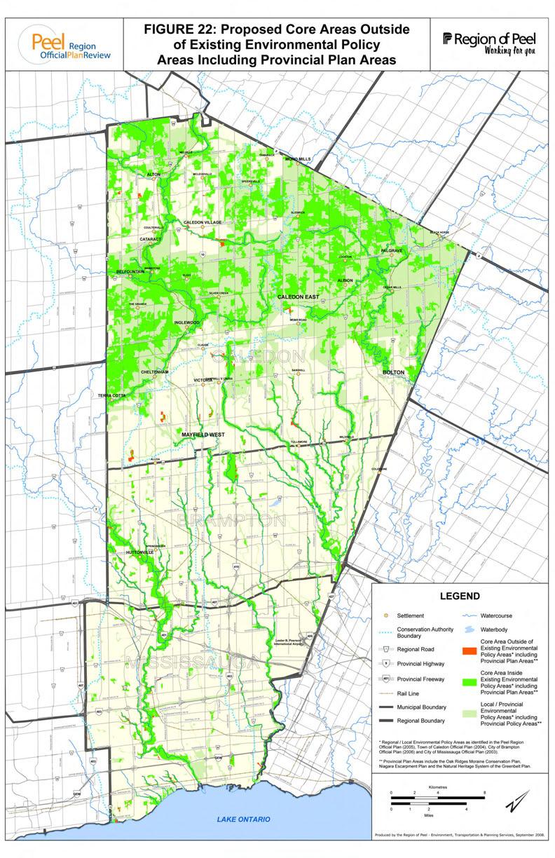
66