Sunshine Coast Timber Supply Area
|
|
|
- Alan Edwards
- 5 years ago
- Views:
Transcription
1 Sunshine Coast Timber Supply Area Vegetation Resources Inventory Photo Interpretation Project Implementation Plan PREPARED BY: GERRY SOMMERS & WARREN NIMCHUK ISSUED: AUGUST 2005 REVISED: MARCH 2006
2 1. INTRODUCTION BACKGROUND INFORMATION VRI PROCESS VRI PLANNING STATE OF CURRENT INVENTORY DOCUMENT OBJECTIVES LANDBASE PHOTO INTERPRETATION PLAN PROJECT OBJECTIVES TARGET AREA POLYGON DELINEATION CALIBRATION DATA SOURCES FIELD CALIBRATION ATTRIBUTE ESTIMATION DIGITAL MAP PROCEDURES DELIVERABLES PROJECT IMPLEMENTATION SCHEDULING AND ESTIMATED COSTS...7 Table 2 Delivery Schedule CERTIFIED PHOTO INTERPRETERS QUALITY CONTROL AND QUALITY ASSURANCE REFERENCE MATERIAL APPROVAL/SIGN-OFF OF VPIP...11 APPENDIX I FLIGHT INDEX...12 ii
3 1. INTRODUCTION 1.1 Background Information The Ministry of Forests and Range (MoFR) has developed a business plan to ensure the successful implementation of the Vegetation Resources Inventory (VRI) ground sampling and photo interpretation projects. The process includes the preparation of VRI Strategic Inventory plans (VSIPs) and Project Implementation Plans (VPIPs). A VSIP provides a general strategic direction for implementing the provincial VRI. The VSIP for the Sunshine Coast Timber Supply Area (TSA) was prepared between August 2005 and March 2006 and should be referred to for details on background information to Vegetation Resources Inventory VRI activities and also for products needed to address the TSA s forest management issues identified by the licensee. A VPIP is a working document that details the specific operational activities associated with the implementation and documentation of a VRI project. It identifies the target areas for new photo interpretation, fieldwork, aerial photography, format of base files and project scheduling. 1.2 VRI Process The VRI is an improved vegetation inventory process for assessing the quantity and quality of BC s timber and other vegetation resources. The VRI addresses the inventory design-related issues raised by the Forest Resources Commission in its 1991 report The Future of Our Forests. The VRI was designed by inventory specialists from government, industry, and academia, and has been approved by the BC Resources Inventory Committee (RIC) with the objective of developing a common set of standards and procedures for Provincial resources inventories. The VRI process consists of several components: 1. The BC Land Cover Classification Scheme (BCLCS) 2. Photo-Interpreted Estimates (VRI Phase I) 3. Spatial products including line work (polygon boundaries) and a VRI file database 4. Ground Sampling (VRI Phase II) Timber emphasis Ecology Coarse woody debris 5. Net Volume Adjustment Factor (NVAF) sampling 6. Within Polygon Variation (WPV) sampling 7. Statistical Adjustment For more information, VRI manuals are available through the internet at
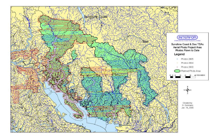
4 1.3 VRI Planning The intent of the VRI planning process is to ensure the inventory baseline products meet a range of applications that are efficiently implemented. After the strategic inventory plan has been prepared, it can be used to prepare coordinated VRI Project Implementation Plans (VPIPs), which are working documents that detail the specific operational activities associated with implementing and documenting the inventory activities identified in the VSIP. The VSIP and VPIPs provide the framework for coordinating the implementation of the provincial VRI over the TSA, and management inventories over priority areas. The VSIP and VPIPs seek to ensure that VRI products address important issues in priority areas, and support resource-specific management interpretations that address forest management issues. This planning process defines the baseline inventory product needs, ensures the right baseline products are selected to meet a range of applications, and achieves efficiencies in the delivery of the desired inventory products. Coordinated inventory planning also maximizes the value of the inventory data produced over issue areas by ensuring the VRI products are useful for addressing more than one resource issue. 1.4 State of Current Inventory The Sunshine Coast TSA was re-inventoried between 1991 and The inventory file has been continually updated to A Phase I VRI was not carried out prior to the last timber supply review, as due to the recent inventory, District staff felt funds would be better spent by initiating a Phase II VRI in the TSA. In 2003, the licensees initiated a project to update the inventory to VRI standards. The first step was to capture new photography marks the third year of attempts to capture 1:15,000 scale color aerial photographs. To date, approximately 85% of the TSA has been flown. In the last TSR (January 1, 2002), the timber supply implications of using the forest cover data adjusted with VRI Phase II data were found to be as follows: 1. All existing coniferous stands over 21 years of age, and all lodgepole pine-leading and deciduous leading stands were assumed to be unmanaged, and the volumes for these stands were underestimated using VDYP. 2. The results of a Phase II VRI were used to adjust heights, ages and volumes for existing stands in the TSA. When Ministry staff compared the VRI data to the forest cover inventory file, the data suggested that the forest cover files underestimated existing stand volumes by approximately 14%. 3. District staff also confirmed that comparisons of cruised volumes for harvested stands suggested that volumes for existing stands were underestimated by the forest cover inventory. The Chief Forester stated the following in the AAC Rationale for Sunshine Coast TSA (January 1, 2002); 2
5 While I am satisfied that the VRI data (Phase II) provides an improved assessment of existing stand volumes relative to the original (forest cover) inventory file, I am also mindful that the methodology associated with this inventory is relatively new, and that some uncertainty is still inherent in the application of the data to pre-existing inventory data, in particular for timber supply review purposes. 1 The Chief Forester also recommended that prior to the next timber supply in the Sunshine Coast TSA, district staff should work with the appropriate agencies to reduce the uncertainty in the VRI data and its application to the timber supply review. There have been limited inventory updates since The MOFR have completed an ad hoc update for TSR 3 using Landsat imagery, forest cover and FDPs (incomplete information for logged openings). The regular updates still need to be completed. In preparation for a new inventory, 1: color photo is being acquired for the Sunshine TSA. Appendix 1 (Flight Index) summarizes the completion status of the Sunshine TSA aerial photography program up to the summer of Document Objectives The objective of this VPIP is to outline and describe the VRI Phase I activities scheduled for completion in the Sunshine Coast TSA. It provides some basic land base information and some background information from the previous Annual Allowable Cut (AAC) Rationale document (October 2000). This document describes the individual phases of the inventory plan including polygon delineation, field sampling, final attributing and digital mapping. The VPIP also describes the quality control and assurance requirements that will ensure all work is done to provincial VRI mapping standards. The VPIP provides a project implementation plan that describes scheduling, air photo type and scale, project personnel, estimated costs and quality assurance. In addition to the information provided in this VPIP, other higher level plans and related planning documents have been prepared and are indicated as links under the appropriate headings. Please refer to the documents for the additional information. 1.6 Landbase The Sunshine Coast Timber Supply Area (TSA) is situated along the southwest coast of British Columbia, extending from Howe Sound in the south to the head of Bute Inlet in the north. The TSA covers approximately 1.5 million hectares and is part of the Sunshine Coast Forest District, one of eight districts in the Coast Forest Region. The mountainous topography and associated high rainfall in the Sunshine Coast TSA produces a diverse climate and ecology. The landscape ranges from rocky shorelines and coastal plains to rugged ice-capped mountains. The Coast Mountains dominate the TSA, with nutrient-rich, moist floodplains in valley bottoms and alpine meadows at higher 1 AAC Rationale for Sunshine Coast TSA (January 1, 2002)
6 elevations. Several significant coastal fjords, most notably Bute, Toba and Jervis inlets occur in the TSA. The forests of the Sunshine Coast TSA are diverse. The main tree species in the forested landbase are hemlock/balsam/spruce, Douglas fir, cedar, and alder-dominated stands. In this report, we have assumed that the forested landbase corresponds to the Vegetated Treed (VT) landbase (BC Landcover Classification Scheme, or BCLCS). About 28% of the TSA land base is considered productive forest land managed by the B.C. Forest Service (approximately hectares). A summary of the TSA land base is provided in Table 1 2. Table 1. Landbase By Forest Cover Area description Hectares Percentage of Total TSA Area Total TSA Area ha 100 % Total Productive Forest Land % Estimated Protected Areas % Total Crown Forested Landbase % 2. PHOTO INTERPRETATION PLAN 2.1 Project Objectives The objective of this VRI inventory is to improve the polygon delineation and attributing in the TSA. The entire TSA was done to previous forest cover inventory standards (refer to section 1.4) and that delineation does not meet current VRI standards. Similarly, final polygon descriptions were done to old forest cover inventory standards and many VRI attributes are missing. The main areas of concern are: Inventory to be brought up to VRI standards (i.e. all vegetated area outside the productive forest is not classified to VRI standards) Check volume estimates for stands over 21 years of age and all lodgepole pine and deciduous leading stands from VDYP models. There is a lack of deciduous information in the TSA Second growth forest stands require better species composition, growth type group height and age estimation (i.e. those young stands that as a result of succession need to be described more accurately) Site indices have been underestimated in areas of old growth 2 Sunshine Coast TSA Analysis Report, Ministry of Forests June
7 A better inventory is required to better define the operablility line Silviculture and free growing information needs significant improvement The new VRI Phase 1 will either address these concerns or serve as a stepping stone for other data improvement projects. Additional detailed information can be found in section 3.4 of the Sunshine Coast TSA VSIP (August 2005; Revised March 2006) The product is a spatial database consisting of unadjusted photo estimates supported by previous and current fieldwork. Ground sampling to check and adjust the photointerpreted attributes is discussed as a separate process (see section 4.3 in the Sunshine Coast TSA VSIP) For details on the forest management issues and inventory product needs identified, please refer to: Sunshine Coast TSA Strategic Inventory Plan (VSIP), August 2005; Revised March Sunshine Coast Timber Supply Area Rationale for (AAC) Determination, January Target Area As identified in the VSIP, the target area for populating the Phase I database with attributes is the entire Sunshine Coast Timber Supply Area landbase, including woodlots, parks, and proposed protected areas. Small, isolated private lots may be also included but large regions of private land will be excluded. There will be no re-delineation of parks or proposed park areas. 2.3 Polygon Delineation Provincially Certified Photo Interpreters will complete a VRI Phase I polygon delineation (which will be based on the BC Land Cover Classification Scheme) according to the most current MoFR VRI standards. For silviculture openings, external boundaries will be delineated as per new photos for vegetation. Internal boundaries will be maintained for all non free-to-grow stands. Silviculture opening numbers will be maintained. Silviculture information provided by the licensees (most likely accessing the RESULTS databases) will be used. Licensees (most likely accessing the RESULTS databases) will provide a list of free growing polygons and these areas will re-delineated with the free growing information utilized as reference material for polygon descriptions. All new roads and landings will be digitized and kept on a separate layer and provided to BMGS for updating the TRIM base. All delineation will be quality control checked and audited to ensure adherence to project objectives and MoFR Standards. 2.4 Calibration Data Sources Calibration data sources are field data reference points established across the land base
8 such as ground calls, air calls, ground observations, ground samples and cruise plots. Field data measurements or estimates at these points are used to assist in the delineation and interpretation of forest vegetation and terrain types. Previous or historical data sources will also be reviewed and those air and ground calls/observations that are still valid will be transferred to the new photos and utilized in new stand delineation and attributing. 2.5 Field Calibration It is the intention for classifiers to complete the delineation, fieldwork and final attributing of the mapsheets assigned to them. In the TSA, calibration fieldwork will be completed in the form of ground calls, ground observations and air calls in priority areas such as: stands having complex species composition second growth types height class 2-3 stands deciduous-coniferous mixes deciduous stands with possible coniferous in-growth stands not previously sampled polygons larger than 20 ha in size multi-layered or uneven aged stands a cross-section of stand stages of development all significant terrain types some vegetated treed and non-treed wetland types Ground and air calls will be established according to VRI fieldwork procedures and standards and delivered in both hardcopy and a digital format. For more information on VRI air call and ground call procedures refer to: Ground Call (Ground Calibration) Data Collection Procedures and Standards (version 3.0, March 2004). Air Call (Air Calibration) Data Collection Procedures and Standards (version 2.0, March 2003). 2.6 Attribute Estimation All attribute estimation will be to MoFR VRI standards and it is expected that the same interpreters will complete all phases of work for a particular set of mapsheets. Initial delineation will be re-assessed during the final classification phase to ensure consistency and that VRI standards are met. All VRI attribute files will be validated through VEGCAPS and delivered in.mdb format consistent with Ministry standards. 2.7 Digital Map Procedures All VRI mapping will be done to provincial mapping standards and specifications. The graphics file will be checked for the integrity of the file structure to guarantee that no corrupt elements or missing pointers internally are present. A check on the parameters entered in each layer or theme will be done. This will confirm that the data meets the 6
9 criteria defined in the Ministry standards and specifications. A log report will indicate the type of errors found on each level. Completed VRI digital graphic files will be submitted in digital standard format and all digitizing must be done to TRIM digitizing standards. In order to produce the Vegetation Information File (VIF), the overlay themes must have closed shapes and unique nodes before information is combined to produce a resultant file. The Ministry of Forests is in the process of creating a revised format for the submission and storage of spatial and attribute data for the VRI program. The new format and database standards will be available by April 3, VRI photo interpretation projects initiated after March 31, 2006 are to be completed to the new standard. All final products relevant to the work completed in a fiscal work will be delivered to the MoFR at the end of that year. 2.8 Deliverables Deliverables will include the following; Digital map and attribute data All new document photos Data sources used Archival data and photos provided by MOFR 3rd party QA reports All final products relevant to the work completed in a fiscal work will be delivered to MOFR at the end of that year. 3. PROJECT IMPLEMENTATION 3.1. Scheduling and Estimated Costs All VRI mapping for the TSA will be completed the new 1: color aerial photography of the project area that is to be acquired in All new photography, will be done to BC government specifications. Table 2 provides a summary of delivery schedule to complete the VRI in the TSA.
10 Table 2 Delivery Schedule Fiscal Year Project Area (Landscape Units) Photo Preparation Polygon Delineation Sample Design Field Data Collection Polygon Descriptions Digital Map Production & Deliverables Quality Control 2005 Cortes/Bute East LU s Fall 2005 Fall 2005 Fall 2005 Fall 2005 Fiscal Year 2006 Fiscal Year 2006 On going 2006 TBD and VPIP will be revised to reflect specific LU s Spring 2006 Spring 2006 April 2006 June-Sept 2006 Oct March 2007 Oct March 2007 On going 2007 TBD and VPIP will be revised to reflect specific LU s Spring 2007 Spring 2007 April 2007 June Aug 2007 Sept March 2008 Oct 2007 March 2008 On going VRI Task Phase I 1:15,000 Color Photo acquisition Estimated Cost $150, Phase I Polygon Delineation and Attribute Estimation* Phase I Air and Ground Calibration* Phase I Air and Ground Calibration Helicopter Cost Estimated 2005 fiscal PHASE I COSTS for LU s identified above and for those tasks identified 0.85 to $1.25 per hectare = $1.2 million to $2.8 million $100 - $150/air call $250 - $300/ground call Dependent upon the sample plan air calls and ground call access* $0.75 per hectare assumes 1.5 million hectares assumes approximately 95 full mapsheet equivalents *Neither VRI nor the previous reinventory standards (manuals) specify how many calibration points are required in a mgt unit to support photo interpretation. Each case is unique and depends on: the amount and composition of productive forest amount of existing, usable calibration data distribution of existing calibration data knowledge and skill of the interpreter(s) and their familiarity with the area lots of other considerations, including available budget. MOF set "benchmarks" for the number of air calls and ground observations with measurements (these replaced the earlier ground calls) that would be established. These were not a Standard, but more a "Best Practice" to ensure that the 8
11 interpreters had adequate data to be confident in their attribute estimates. Note, also, that this "benchmark" specified that the air and ground calls were done by the individual interpreters in the areas they were assigned, to calibrate themselves for later work with the photos Certified Photo Interpreters At least 50% of the photo interpreters must be VRI certified and all non-certified individuals must have successfully completed the Basic VRI Photo Interpretation Course. Non-certified interpreters must also work directly under the supervision of a certified interpreter for training and quality control. All supervising certified interpreters are responsible for the quality of work completed under their certification Quality Control and Quality Assurance A certified photo interpreter having at least 5 years of coastal photo interpretation experience in BC will conduct proper quality control on 2-5% of each phase of the project. Documentation of all quality control checks will be maintained and made available to the Project Coordinator. As part of the quality control program, the VRI contractor will hold a field data collection workshop in the project area at the commencement of the fieldwork program. The purpose of the workshop is to make sure that all individuals involved in the field data collection, monitoring and/or evaluation have a common understanding of the standards, specifications, and procedures that will be employed in the TSA. It will also ensure that all vegetation attributes are collected in a consistent and accurate manner. Attending will be: Project Manager and Project Supervisors VRI interpreters Contracted resources Invited to attend will include: Sunshine Coast TSA Project Coordinator Quality Assurance Contractor Ministry VRI specialists At the beginning of the fieldwork, the project VRI Supervisor will accompany each interpreter in the field for a day and check their work as the plots are being established. Any errors or discrepancies will be corrected on site until the work meets the required standards of the supervisor. The Project Supervisor will accompany the interpreters on their first flight plan to ensure 3 document from Derek Challenger, MoFR, June 23, 2005
12 that air call estimates are complete and correct. All subsequent air calls will be flown with two certified photo interpreters, in the helicopter, so that the second interpreter can check all estimates. The Project Supervisor will also ensure that the photo interpreters establish the air calls and a majority of the ground calls on their assigned mapsheets.. An independent contractor will conduct an independent and comprehensive quality assurance program. This contractor will ensure the VRI contractor produces a consistent and reliable product. The third party Quality Assurance Contractor will have a minimum of 5 years VRI delineation, fieldwork and final attributing experience in Coastal BC and will check all phases of the VRI s follows: Delineation approximately 2% check of polygons for 80% of mapsheets Fieldwork approximately 7.5% check of ground calls and air calls representative of the project area Final Attributing approximately 2% check of polygons for 80% of mapsheets The project coordinator will ensure the inventory contractor(s) conducting the inventory provides adequate and ongoing internal quality assurance (QA) of all deliverables. The results of all quality control and quality assurance will be recorded on approved QA/QC forms. For more information, please refer to the following: Quality Assurance Procedures for Photo Interpretation (version 2.0, March 2004) 4. REFERENCE MATERIAL Each member of the inventory team will have the following reference material available for the duration of the project: Sunshine Coast TSA VRI Strategic Inventory Plan (2006) Sunshine Coast TSA VRI Project Implementation Plan (2006) VRI BC Land Cover Classification Scheme (2002) VRI Photo Interpretation Procedures (2002) VRI Quality Assurance Procedures for Photo Interpretation (2004) VRI Photo Interpretation Standards (1998) VRI Ground Call Data Collection Procedures and Standards (2004) Air Call Data Collection Procedures and Standards (2003) MSRM Vector Cleaning Specifications (1997) MOF Forest Inventory Manual MOF Biodiversity Guidebook MOF Color Stereogram, Handbook MOF Black and White Stereogram Handbook Several tree and plant field guide books 10
13 5. APPROVAL/SIGN-OFF OF VPIP I have read and concur that the Sunshine Coast TSA Project Implementation Plan (VPIP), meets current Vegetation Resources Inventory Standards and Ministry of Forests and Range business needs. Manager, Date Vegetation Resources Inventory Section Forest Analysis and Inventory Branch Ministry of Forests and Range
14 12 Appendix I Flight Index
15