Monitoring Forest Dynamics in Northeastern China in Support of GOFC
|
|
|
- Juliet Evans
- 5 years ago
- Views:
Transcription
1 Monitoring Forest Dynamics in Northeastern China in Support of GOFC Principal Investigator: Dr. Guoqing Sun, University of Maryland Co-Principal Investigator: Dr. Darrel L. Williams, NASA s Goddard Space Flight Center Co-Investigators: Dr. Z. Li, Institute of Forest Resources Information Technology, Chinese Academy of Forestry Dr. X. Zhan, University of Maryland Prof. L. Tang, China Remote Satellite Ground Station, Chinese Academy of Sciences Dr. K. Jon Ranson, NASA s Goddard Space Flight Center LCLUC Science Team Meeting on GOFC and Disturbance 20 th 22 nd September 2000, Rockville, Maryland
2 EXECUTIVE SUMMARY The forests in Northeastern China have been undergoing dramatic changes due to forest fire, insect infestation, massive logging, agricultural conversion, and afforestation. These changes affect the climate, the ecosystem, the economy and living heritage in the region, not to mention the possible impact on the global carbon cycle. The aim of this proposed study is to develop a forest monitoring system in a region that undergoes rapid land cover changes. This monitoring system will utilize satellite remote sensing data, Geographic Information System techniques, and state-ofthe-art methodologies for forest cover mapping and change detection. This study will take advantage of a Chinese-funded forest mapping program using SAR data (currently conducted by Co-I Dr. Li), historic Landsat-5 data, and forest cover maps available in China. Dr. John Townshend s algorithms for MODIS 250m land cover change indicator will be adopted for this project. In return, the updated high resolution land cover map of the region from this project may serve as a validation data set for MODIS land products. We will work closely with Dr. Samuel Goward s Landsat-7 team and forest classification in this region may serve as a case study for his Research Environment for Advanced Landsat Monitoring (REALM). This study will fulfill the requirements stated in the NRA by developing operational methods and a complete system for forest monitoring, and by providing GOFC-defined data products for other GOFC partners and data users.
3 RESEARCH OBJECTIVES The research objectives are devoted to developing the three major components for the system: updated base cover maps, change detection function, and database management system 1) Develop an updated base map of forest cover by combined use of ERS interferometric tandem SAR data and Landsat-7 ETM+ data. Research emphasis will be placed on the standardization of the classification methods, and the algorithms for deriving forest physical parameters from SAR and ETM+ data. 2) Adopt UMD MODIS Land Cover Change Mapping Algorithms to develop operational procedures for forest change detection and analysis by combined use of multi-temporal low spatial resolution MODIS 250m data and high spatial resolution Landsat-7 ETM+ and radar data; 3) Develop a PC-based GIS database to provide updated forest cover/land use maps, and other data sets for forest dynamics monitoring and ecological studies in this region; Then, to test the scientific use of the forest monitoring system we will: 4) Perform test runs in a test site to predict forest dynamics using this database and selected forest growth models useful for forest management strategies and carbon dynamic assessments.
4 The study area The study area includes three provinces in Northeastern China: Liaoning, Jilin and Heilongjiang, and the eastern part of Inner Mongolia Autonomous Region. This area accounts for about 13% (1.25 million km 2 ) of the land area, 10% (125 million) of the population, and 30% (36 million ha) of the forest area in China. It is the eastern part of a region called "the Three-north Forest Shelter-Belt." A shelter-belt Afforestation Program (Green Great Wall Program) in the "Northeast, North and Northwest" (called "Three North") of China was started in 1978, and will be completed in 2025.
5

6 Forest Classification from AVHRR data by UMD. The rest of the areas in Northeastern China are agricultural land, Grassland and wetland. Evergreen Needleleaf Deciduous Needleleaf Mixed Forests Deciduous Broadleaf
 agricultural conversion, d) deciduous Xiaoxinanling e) mixed forests Changbai Mountain f) mixed forests g) deciduous")
7 c f d a b c e The test sites in the three major forest areas: Daxinganling a) Larix gmelinni burned in 1987 b) insect infestation, c) agricultural conversion, d) deciduous Xiaoxinanling e) mixed forests Changbai Mountain f) mixed forests g) deciduous broadleaf f g


8 Landscape of Grassland in Inner Mongolia Plateau Farmland Shelter-belt in Plain of Northern China Forest for Protection Against Wind & Drifting Sand Poplar & Birch Natural Hybrid Forest in the Mountain Area of the Northern China

9 Field observation at Southern Daxinganling, Heilongjiang Province in June 1999
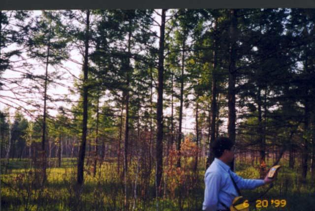
10 GPS measurement

11 Field survey in Changbai Mountain Area, Jilin Province, China, June, 2000


12 Forests in Changbai Mountain Area, Jilin Province, China, June, 2000

13 Forest disturbances: selective cut

14 Clear cut and Ginseng farm
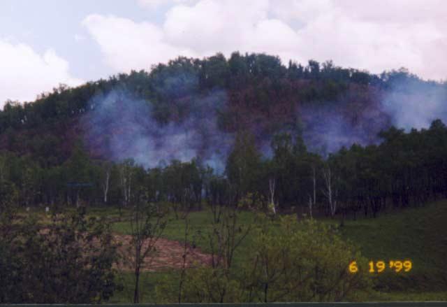
15 Fire


16 Forest Fire, May-June 1987 TM mosaic image after the forest fire in May and June The burned area is about 1 million ha. The center Lat/Long is about 53N/124E. (From RSGS, China) Landsat-7 image, P121/R23, Sept. 5, 1999 Landsat-7 image, P121/R23, June 19, 2000


17 Forest fire, May-June, 2000 May 11, 2000 July 28, 1999 August 6, 1999 May 20, 2000

18 A tank used for forest fire fighting
19 Data Available Historical (1985, 1990) land use and forest maps in digital format Political boundaries, transportation, hydrology networks in ARC/INFO format Fixed sampling sites for national forest resources inventory and monitoring Detailed forest stand management records from forest bureaus Allometric equations of biomass for major species in this region Satellite data Landsat-7 ETM Interferometry Land Use (ILU) data from ERS tandem SAR data or forest/non-forest maps from the ILU data JERS-1 data at test sites MODIS 250m data Landsat-4 and 5 data Others (SRTM SAR, ENVISAT ASAR, and ALOS POLSAR, VCL)

20 China s forests, and the four phases of the forest mapping project currently conducted by Dr. Li s team in Institute of Forest Resource Information Techniques, Chinese Academy of Forestry. The first phase was started in June 1999.

21 Permanent sample sites for forest resource inventory in Northern Heilongjiang Province. Color shows forest species and ages in 1990 (from Forest Administration Bureau of Daxinganling, Ministry of Forestry, China).

22 Forest inventory maps in 2000, Lushuihe Forest Bureau, Jilin
23 Specification of the fields (total 50) in stand data sheet 1. Region No. 2. Stand No. 3. Area (hectare) 4. Land type 1-forest 2-open stand (crown cover < 20%) 3-shrub 4-5. Ownership 7. Forest type 8. Origin 1-timber 2-shelter 3-special 1- plantation 2-natural 9. Dominate species 10. Species composition 11. Average age 12. Average diameter 15. Average height 16. Crown closure ( ) 17. Timber volume (cubic meter per hectare) 18. Stem density (number of trees per hectare) 19. Management type 20. Plantation species 23. Stems planted 24. Survive rate 25. Plantation age 26. Productivity 33. Soil texture 34. Soil thickness 38. Understory species

24 Landsat-7 images, Spetember 2, 1999 (bands 5, 4, 2) 42-9 Broadleaf mix 93 yrs. 19m, 60% Pinus koraiensis 15 yrs 4m, 60% Populus davidiana : 7 year, 2m, 40% 49-2 Populus davidiana, 20 yrs. 7m 70% 49-8 Pinus koraiensis, 175 yrs. 23m, 70% 54-7 Pinus koraiensis, 120 yrs. 17m, 60% Larix olgeusis 11 yrs. 3m 80%

25 Ordered Landsat-7 images in Daxinganling and Changbai areas Scene received


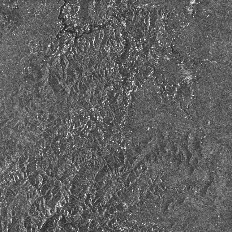
26 JERS-1 LHH SAR Images of 1998 P88 P90 P89 R229 R230 Covered by Landsat 7 P116/R31
27 Methods Divide North-Eastern China into ecological zone with uniform imaging conditions Order ETM data at similar dates within an ecological zone Apply unsupervised/supervised classification for each zone using REALM system TM and ETM images Forest maps (~85 and ~90) Interferometry SAR Land Use InSAR data Forest/non-forest map DEM Soil map Climate maps (precip., temp.) Boundaries (political, ecological) Permanent Sample sites Other field data (GPS), VCL (REALM) Classification: Training site statistics Clustering, decision-tree MLC, Neural Net Region selection polygon Attribute Circular sample Others Change detection Forest dynamics modeling Carbon storage changes MODIS data and Product Change Detection
28 EXPECTED RESULTS The following results can be expected from this study: Through the collaboration between researchers in China and USA, a validated fine-resolution forest cover map of Northeastern China and the semi-automatic classification methods will be produced. The database and operational procedures for forest monitoring in Northeastern China using multi-sensor satellite data (temporal coarse resolution MODIS data and fine resolution Landsat-7 and SAR data) will be developed at University of Maryland and NASA's GSFC. The 250m MODIS land cover change detection method from UMD MODIS Team will be directly used for change detection, while the high-resolution data sets and field observations from this project will be used to conduct validation of the 250m MODIS product in this region. The potential of using data from new sensors (e.g. SRTM, VCL) for detailed structure parameters estimation will be investigated and algorithms will be developed. The feasibility of using remote sensing data and forest growth models for predicting forest development will be tested. Positive application will provide the impetus for future work in this area.