PROJECT SCOPE OF WORK CITY OF TOWN AND COUNTRY STORMWATER PROGRAM
|
|
|
- Whitney May
- 5 years ago
- Views:
Transcription

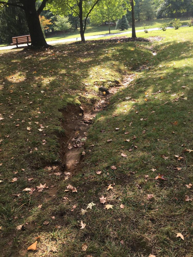
1 PROJECT SCOPE OF WORK CITY OF TOWN AND COUNTRY STORMWATER PROGRAM Project ID Number: 2- Problem: Storm runoff from the park flows overland through a gap in a berm and then into the neighboring subdivision to an area inlet. The berm had been installed as a buffer between the park and Wheatfield Farm Subdivision. The runoff has causing erosion that has progressed to six-inch deep and 2-inch wide rills. At intermediate flat spots in the drainage way, ponding occurs. Gutter drains from adjacent properties have been installed and have contributed to the erosion. Proposed Solution: Close the existing berm along the east side of the park property and install a storm sewer to divert stormwater from overland flow to the storm sewer system in Wheatfield Farm Subdivision. Description of Proposed Alignment: At the upper limits of the project, construct a bioswale with an underdrain system that runs easterly to a new area inlet just to the west of the existing berm located along the east property line of the park. Continue from the area inlet easterly along the north property line of 327 Starbuck Road with a new 2-inch sewer to a new area inlet. Continue from the area inlet to the existing area inlet at the downstream end of the project. Required Easements: 327 Starbuck Road (Temporary Construction Easement) 327 Starbuck Road (Permanent Easement) 339 Starbuck Road (Temporary Construction Easement) 339 Starbuck Road (Permanent Easement) 369 Wheatfield Farm Road (Temporary Construction Easement) 369 Wheatfield Farm Road (Permanent Easement) 36 Wheatfield Farm Road (Temporary Construction Easement) 333 Clayton Road (Temporary Construction Easement) 333 Clayton Road (Permanent Easement) Commentary: There is some erosion at the upper limits of the project, but the majority of the erosion is caused by private drains as shown in the photographs. Depending on MSD review, additional water quality BMP s or upstream detention may be required. PROJECT SCOPE OF WORK
: Location Benefit Identification (LBI) Project Points: Cost to Benefit Ratio: Coordination Required: 6")
 B: Frequent")
2 PROJECT INFORMATION SUMMARY CITY OF TOWN AND COUNTRY STORMWATER PROGRAM Project Name: Longview Farm Park / Wheatfield Farm Subdivision Project ID Number: 2- Number of Properties Impacted: Number of Easements Required: Number of Properties Benefited: Opinion of Probable Construction Cost (OPC): Location Benefit Identification (LBI) Project Points: Cost to Benefit Ratio: Coordination Required: 6 $344, ,238 Project Source: x Citizen Complaint Municipality Maintenance Government Agency Category of Problem: Description A: Frequent structural flooding from creeks or rivers (floodplain) B: Frequent structural flooding from overland flow (non-floodplain) C: Frequent roadway flooding x MSD x Corps of Engineers MO DNR MODOT County Highways City Streets x City Parks County Parks x Municipality: City of Town & Country Railroad: x : Local Utility Service Providers Attached Supplemental Information: x Project Scope of Work x Conceptual Plan Drawing x Itemized Opinion of Probable Construction Cost (OPC) x Location Benefit Identification (LBI) Forms x Existing Condition Photos D: Infrequent structural flooding from creeks or rivers (floodplain) E: Infrequent structural flooding from overland flow (non-floodplain) F: Infrequent roadway flooding G: High risk structural erosion H: High risk roadway erosion x I: Yard erosion J: Moderate risk structural erosion K: Moderate risk roadway erosion x L: Erosion or flooding of common ground or unmaintained area x M: Yard flooding N: Flooding from inadequate sinkhole O: Flooding from inadequate roadway drainage x P: Maintenance of stormwater system facilities Q: Notes: MSD/MO American Water Base Map Number(s): FEMA FIR Map Number(s): 2P 2989C63H PROJECT INFORMATION SUMMARY
3 OPINION OF PROBABLE CONSTRUCTION COST CITY OF TOWN AND COUNTRY STORMWATER PROGRAM Project Name: Longview Farm Park - Wheatfield Farm Subdivision Project ID Number: 2- ITEM ESTIMATED UNIT EXTENDED NUMBER PAY ITEM DESCRIPTION QUANTITY UNIT PRICE PRICE Mobilization Lump Sum $,. $,. 2 Additional Fill 72 Cubic yards $22. $, Bioswale Seeding & Plantings 78 Square Yards $4. $8,. 4 Compaction of Fill 68 Cubic Yards $22. $,7. Connection To Existing Inlet (2" thru 24" Pipe) Place $2,36. $2,36. 6 Excavation Class "C",263 Cubic Yards $28. $3, Unclassified Excavation 74 Cubic Yards $. $3,2. 8 Geofabric 2 Square Yards $2. $24. 9 Grade Control Structure Each $6,9. $6,9. Granular Backfill 4 Cubic Yards $. $22. Inlet - Area Each $2,. $2,. 2 Inlet Manhole - Top Section Each $,7. $,7. 3 Manhole Standard Construction 6 Linear Feet $33. $2,. 4 PVC Pipe 6 Inch Linear Feet $32. $3,2. Pipe Sewer 2 Inch (Storm) 378 Linear Feet $9. $34,2. 6 Sidewalks & Driveways Concrete - Rem. And Rep. 2 Square Yards $. $,2. 7 Sodding - Bluegrass 2,984 Square Yards $3. $38, Protection and Restoration of Site Lump Sum $22,. $22,. SUB-TOTAL - CONSTRUCTION: $97,646.6 Estimated MSD Plan Review Submittal Fee: $4. Estimated MSD Conceptual Review Fee: $2,. Estimated MSD Plan Review Fee: $42.7 Estimated MSD Construction Permit Fee: $9. Estimated MSD Construction Inspection Fee: $2,3. Estimated Engineering Fee: $4,. Estimated Geotechnical Engineering Fee: $6,. Estimated Property Survey/Strip Map Preparation Fee: $2,8. Estimated Property Title/Easement Search Report Fee: $,2. Estimated Topographic Survey Fee: $9,4. Estimated Property Rights Acquisition Document Preparation Fee: $2,2. Estimated Cost of Easements: $,. Estimated Construction Survey Fee: $6. SUB-TOTAL: $264,96.6 3% Contingency: $79,47.98 TOTAL: $344,378.8 OPINION OF PROBABLE CONSTRUCTION COST
4 City of Town & Country Location Benefit Identification Project Id Number: 2- Location Address / Description: 32 Clayton Rd Total Calculated Benefit Points: 4. Evaluation Category Problem Type Benefit Points High Medium Low Retaining Wall (Public) Street ROW Retaining Wall (Private) Yard 3 Unimproved Channel (Trail) 6 Erosion Erosion Subtotal Impassable Traffic Passable Traffic Accessory Structure (Trail) 6 Flooding Flooding Subtotal 7 Unimproved Channel 3 Street Gutter Swale / Berm (Trail) 6 Maintenance Maintenance Subtotal Street Drainage Drainage Subtotal Frequency Rating Degree of Risk > / year Life / Limb / year Health. / years / years Property Value Frequency Rating Multiplier Degree of Risk Multiplier.
5 City of Town & Country Location Benefit Identification Project Id Number: 2- Location Address / Description: 339 Starbuck Rd Total Calculated Benefit Points:. Evaluation Category Problem Type Benefit Points High Medium Low Retaining Wall (Public) Street ROW Retaining Wall (Private) Yard 3 Unimproved Channel Erosion Erosion Subtotal 4 Impassable Traffic Passable Traffic Accessory Structure Flooding Flooding Subtotal Unimproved Channel 3 Street Gutter Swale / Berm Maintenance Maintenance Subtotal 4 Street Drainage Drainage Subtotal Frequency Rating Degree of Risk > / year Life / Limb / year Health / years Property Value. / years Frequency Rating Multiplier Degree of Risk Multiplier.
6 City of Town & Country Location Benefit Identification Project Id Number: 2- Location Address / Description: 327 Starbuck Rd Total Calculated Benefit Points: 3. Evaluation Category Problem Type Benefit Points High Medium Low Retaining Wall (Public) Street ROW Retaining Wall (Private) 6 Yard 3 Unimproved Channel (Fence) 6 Erosion Erosion Subtotal 6 Impassable Traffic Passable Traffic Accessory Structure Flooding Flooding Subtotal 6 Unimproved Channel Street Gutter Swale / Berm (Fence) 6 Maintenance Maintenance Subtotal 3 Street Drainage Drainage Subtotal Frequency Rating Degree of Risk > / year Life / Limb / year Health / years Property Value. / years Frequency Rating Multiplier Degree of Risk Multiplier.
7 City of Town & Country Location Benefit Identification Project Id Number: 2- Location Address / Description: 369 Wheatfield Farm Rd Total Calculated Benefit Points: 2. Evaluation Category Problem Type Benefit Points High Medium Low Retaining Wall (Public) Street ROW Retaining Wall (Private) Yard 3 Unimproved Channel (Fence) 6 Erosion Erosion Subtotal Impassable Traffic Passable Traffic Accessory Structure Flooding Flooding Subtotal Unimproved Channel Street Gutter Swale / Berm (Fence) 6 Maintenance Maintenance Subtotal 8 Street Drainage Drainage Subtotal Frequency Rating Degree of Risk > / year Life / Limb / year Health / years Property Value. / years Frequency Rating Multiplier Degree of Risk Multiplier.
8 City of Town & Country Location Benefit Identification Project Id Number: 2- Location Address / Description: 3 Starbuck Rd Total Calculated Benefit Points:.8 Evaluation Category Problem Type Benefit Points High Medium Low Retaining Wall (Public) Street ROW Retaining Wall (Private) Yard 3 Unimproved Channel Erosion Erosion Subtotal 4 Impassable Traffic Passable Traffic Accessory Structure Flooding Flooding Subtotal Unimproved Channel Street Gutter Swale / Berm Maintenance Maintenance Subtotal 2 Street Drainage Drainage Subtotal > / year / year Health / years Property Value. / years Frequency Rating Life / Limb Degree of Risk Frequency Rating Multiplier Degree of Risk Multiplier.
9 City of Town & Country Location Benefit Identification Project Id Number: 2- Location Address / Description: 377 Wheatfield Farm Rd Total Calculated Benefit Points:.7 Evaluation Category Problem Type Benefit Points High Medium Low Retaining Wall (Public) Street ROW Retaining Wall (Private) Yard 3 Unimproved Channel Erosion Erosion Subtotal 4 Impassable Traffic Passable Traffic Accessory Structure 3 Flooding Flooding Subtotal 4 Unimproved Channel Street Gutter Swale / Berm 6 Maintenance Maintenance Subtotal 8 Street Drainage Drainage Subtotal > / year / year Health / years Property Value. / years Frequency Rating Life / Limb Degree of Risk Frequency Rating Multiplier Degree of Risk Multiplier.


 Park.")

10 2- Existing berm on east side of Longview Farm Park Looking south from playground on Longview Farm Park Existing berm on east side of Longview Farm Park. (27) Looking south from playground on Longview Farm Park. (27) Looking south along the west side of existing berm at Longview Farm Park

 Looking north at playground.")


11 2- Fence, east side of Longview Farm Park and west side of Wheatfield Farms Subdivision. (27) Looking north at playground. (27) Fence, east side of Longview Farm Park and west side of Wheatfield Farms Subdivision West side of Wheatfield Farms Subdivision on other side of fence. (27)


")

12 2- Erosion along south fence line of 369 Wheatfield Farm Erosion and private drain system along south fence line of 369 Wheatfield Farm Private drain systems entering area inlet in backyard of 369 Wheatfield Farm Erosion along south fence line of 369 Wheatfield Farm (27) Private drain systems entering area inlet in backyard of 369 Wheatfield Farm (27)


13 U V 34 Existing 923 -ft Contours Project Location 64, % Sanitary Manhole " ) Stormwater Inlet 27 64, % # * P-27S V U 4 Sanitary Gravity Main Stormwater Manhole Stormwater Intake/Outfall Stormwater Gravity Main Stormwater Channel Impervious Pavement V U Parcels 64 2P-77D '' 2 2P-28S 333 2P-29S '' P-78D Proposed WHEATFIELD FARM RD 2'' Proposed Improvements Strip Map Limits Topo Limits FEMA Flood Hazard Zone Regulatory Floodway 62 2P-62S 2P-28D P-77S 3 STARBUCK RD '' 2P-43D '' $344,379,238 Problem Description Improve storm sewer collection and conveyance system P-76S Easements Required Properties Impacted Properties Benefited Project Benefit Points Conceptual Cost Cost to Benefit Ratio Proposed Solution Description 2P-34S 2P-3D RD.2% Annual Chance Flood Hazard Park runoff contributing to downstream yard erosion N TO AY CL P-29D '' P-63S 2'' % Annual Chance Flood Hazard P-79D Feet inch = feet Warning: If this bar does not measure " then drawing is not to scale City of Town & Country Stormwater Program Longview Farm Park / Wheatfield Farm Subdivision 2-