K&C Phase 4 Status report
|
|
|
- Victoria Phillips
- 5 years ago
- Views:
Transcription
 using L-band SAR data Shaun Quegan, João Carreiras National")
 Brazil Science Team meeting #22 Tokyo, Japan,")
1 K&C Phase 4 Status report Measuring above ground biomass and changes over Brazilian tropical secondary forests and savanna woodlands (Cerrado) using L-band SAR data Shaun Quegan, João Carreiras National Centre for Earth Observation (NCEO) University of Sheffield United Kingdom Edson Sano Institute of Environment and Renewable Natural Resources (IBAMA) Brazil Science Team meeting #22 Tokyo, Japan, February 16-18, 2016
2 The importance of tropical secondary forests establishing on abandoned farmland act as a carbon sink: accumulation on average ~10 Mg ha -1 yr -1 and important at recovering biodiversity Amazon: ~ 1/3 deforested land supporting secondary forests at some stage in the 1990s and 2000s (Lucas et al., 2000; Carreiras et al., 2006) however, still high uncertainty in terms of contribution of its dynamics to the global carbon cycle (South America, 50%; Pan et al., 2011)
3 Project outline and objectives Assess the sensitivity of L-band SAR data to forest above ground biomass in a range of lower-carbon tropical regions in Brazil : secondary forests and savanna woodlands (Cerrado) Value of L-band data for measuring forest above ground biomass: sensitivity up to ~ 100 t/ha (saturation level at this frequency) developing forest monitoring systems (activity data + emission factors) in regions with lower biomass density
4 Support of K&C Thematic Drivers changes in forest biomass have an impact in terms of climate: deforestation: source of carbon to the atmosphere forest growth: carbon removal from the atmosphere uncertainties in these biomass-related fluxes in terms of the global carbon budget -> currently estimated as the residual term (exception: Pan et al., 2011, using observational data) accurate maps of secondary forests and Cerrado biomass and change reduce uncertainty carbon accounting (UNFCCC)
 Santarém (Pará) Machadinho d")
 Barreiras (Bahia) Luis Eduardo")
5 Study areas Secondary forests Manaus (Amazonas) Santarém (Pará) Machadinho d Oeste (Rondônia) Savanna woodland (Cerrado) Barreiras (Bahia) Luis Eduardo Magalhães (Bahia)
6 Preliminary results What is the capability of optical and L-band SAR data to discriminate the age of tropical secondary forests? access to time series maps of non-forest, secondary forest and mature forest spanning three decades (1980s - ) over the three sites precise location of areas with secondary forests of known age ALOS PALSAR catalogue dual-pol (HH+HV) level 1.1, JAXA PI programme Landsat 5 TM surface reflectance data USGS
7 Discrimination age of secondary forests HH + HV discrimination up to ~ 10 years -> leveling-off TM4 + TM5 (and TM7), sensitivity up to ~ 10 years
 TM3, TM4, TM5, TM7 (Landsat 5 TM) algorithm: non-parametric Random Forests (Breiman, 2001) R randomforest")
8 Mapping secondary forest age classes 2 regrowth age classes initial-intermediate : 10 yr advanced: 11 yr also non-forest and mature forest 6 predictors HH, HV (ALOS PALSAR) TM3, TM4, TM5, TM7 (Landsat 5 TM) algorithm: non-parametric Random Forests (Breiman, 2001) R randomforest package
9 Mapping secondary forest age classes non-forest observed (# plots) initialintermediate advanced mature forest Total Commission Error non-forest 5, , Predicted (# plots) initialintermediate advanced , mature forest ,004 2, Total 5, ,160 2,104 9,624 Omission Error overall accuracy: 95% ini-int regrowth: misclassification (16-21%) mainly as advanced regrowth advanced regrowth: misclassification (17-19%) mainly as ini-int and mature forest
10 Mapping secondary forest age classes Surface reflectance in the near infrared and shortwave infrared more important at discriminating the age of regrowth classes than L-band dual-pol backscatter


11 Mapping secondary forest age classes: Manaus, 2010


12 Mapping secondary forest age classes: Santarém, 2010


13 Mapping secondary forest age classes: Machadinho d Oeste, 2010
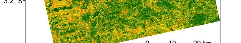
14 Cerrado, Brazil Barreiras + Luis Eduardo Magalhães (Bahia) ALOS PALSAR mosaics generated between


15 Some examples of frontier deforestation over Cerrado important to monitor and know the contribution of these disturbances in terms of the regional carbon budget requires information about the distribution of predisturbance biomass
 Source ALTO Alto Paraíso/GO 10 109 58 Miranda (2012) PNCV Alto Paraíso/GO 10 92 48 Miranda (2012) SIL Silvânia/GO 9 151 64 Miranda (2012) SD São Desidério/BA 9 144 129 Miranda (2012) COR")
16 Compilation of biomass plot data over Cerrado savanna adapted from Miranda (2012) 23 studies and ~160 sites Site name Municipality/ State # plots Average biomass (Mg ha -1 ) Standard deviation (Mg ha -1 ) Source ALTO Alto Paraíso/GO Miranda (2012) PNCV Alto Paraíso/GO Miranda (2012) SIL Silvânia/GO Miranda (2012) SD São Desidério/BA Miranda (2012) COR Correntina/BA Miranda (2012) INTER Distrito Federal Miranda (2012) VALE Distrito Federal Miranda (2012) JBBCV Distrito Federal Miranda (2012)
17 Project milestones Initial maps of AGB of secondary forests and savanna woodlands (cerrado) and their changes (mid-2016) Validation of above-ground biomass maps of secondary forests and savanna woodlands (cerrado), associated error analysis and final map products, including error maps (late 2017)


18 Data sharing Manaus August 2014 Adv22_18 ASF = 19 yr PALU = 7 yr FC = 2x Adv12_2 ASF = 23 yr PALU = 1 yr FC = 2x
19 Deliverables Above-ground biomass map of secondary forests over areas of approximately 200x200 km around each regrowth hotspot site (Manaus, Santarém and Machadinho d Oeste) Above-ground biomass map of Cerrado in the eastern part of the municipalities of Barreiras and Luis Eduardo Magalhães, Bahia State Change maps for these regions and assessment of their implications for carbon and biodiversity
20 Acknowledgements JAXA K&C 4: PIKC1621 JAXA ALOS 4 th RA: PI1208 Foundation for Science and Technology, Portugal, REGROWTH-BR (PTDC/AGR-CFL/114908/2009) UK NERC National Centre for Earth Observation (NCEO) (R8/H12/82) United States Geological Survey (USGS) Thank you!!! Questions?