Urban Monitoring of Spatial Development of Moscow State Region
|
|
|
- Lynne Powell
- 5 years ago
- Views:
Transcription
1 State Region Boris Feldman, NIiPI of Urban planning, Moscow, Russia Alexander Antonov, NIiPI of Urban planning, Moscow, Russia Roman Feldman, NIiPI of Urban planning, Moscow, Russia 1. Moscow Oblast According to the information from Moscow oblast government approximately 35-40% of it s territory is used for agricultural purposes, about of 45% are covered by forest or forest like vegetation. The northern, western and eastern frontiers are the least involved in agriculture. In the southern part of the region, especially to the south of the Oka river, 60 % of the territory are used in agriculture. Agriculture tends to have suburban specialization. Plant growing is developed in the southern part of the region. The most part of cultivation area (more than 3/5) is occupied by fodder crops. Considerable areas are occupied by grain crops such as wheat, barley, oats and rye. Potato growing also plays an important role. 2. Theoretical Background of Lands Detection on the Base of Remote Sensing Data Agricultural, forest, rural and settelment s lands in Moscow oblast are the four main types of area usage. But as we see only the agricultural lands are mostly used for plant growing. Gardening takes place only on the lands of gardening cooperative. As a consequence the most part of agricultural lands are occupied by cultivated plants which have their special rates of absorption and reflection in different parts of the spectrum. In the red spectral band (0,6 0,7 mcm) lies the maximum of solar radiation absorption performed by chlorophyll of vascular plants. In infra-red spectrum lies the maximum of reflection performed by cellular construction of a leaf. High photosynthetic activity (which is usually connected with dense vegetation) leads to less reflection in the red spectral band and more reflection in the infra-red. Besides that vascular plants usually have more green biomass with especially high water saturation which allows to distinguish them from plants with natural vegetation cycle using another spectral channels located in near and middle infra-red band. 3. Identification of Different Types of Territory Using Combinations of Spectral Channels In this study archive data from satellites Landsat 5 TM / Landsat 7 ETM+ were used for analysis. Images from satellites ASTER, IRS 1C/1D, IRS P-6 were used as supplementary data. Landsat 5 data for the period of were analyzed for identification of initial state of the territory and Landsat 5/7 data for the period of were analyzed for identification of it s contemporary state. The last years we have used the SPOT-5 images. This images can be synthesized to high resolution of 2.5 meters to pixel, but they have only Green-Red-Near_Red-Middle_Red channels, as Landsat-5/7 has 8 channels from Blue to termal. 1
2 4. Principles of Identification of the Territories Used for Agricultural Purposes For identification of the territories used for various purposes the area of Moscow oblast was divided into several model classes. Every pixel of the image was rated as one of model subclasses. According to the results of processing the analysis of pixel contiguity was made. After it pixels were combined into areas with similar spectral characteristics. Using combining and generalization these areas were reduced to the one of model classes as of 2002 and 2011 years. Each area was analyzed in order to correlate it with one of model classes at the beginning and in the end of the specified period to identify if that territory was used for agricultural purposes. Identification of agricultural lands borders changes was made in the same way. Following model classes were distinguished: 1. Water water objects and wet dark forests which can t be distinguished from them 2. Forest areas covered with forests 3. Bush - bushes or perennial herbs 4. Urban_High dense stone building of populated points or industrial and warehouse territories 5. Urban_Low rural scarce building where the area of green spaces is much more than the area occupied by buildings. 6. Agr agricultural vegetation 7. Ground territories of open soil. They include arable lands and less territories of open pits, construction sites etc. 8. PPA (Populated areas) territories inside settlement borders not covered with buildings. This class also includes highways and main railroads. Geological, soil and climatic conditions allow to use the whole territory of Moscow oblast for agricultural purposes. It means that only the territories which are not suitable for agriculture can t be used for agricultural purposes. All areas were finally referred one of three metagrops: 1. Territory used for agricultural purposes or suitable for agriculture. 2. Territory which is not suitable for agricultural purposes, that include following land categories: Water objects of all classes Swamps and peatbogs Forests Small glades in forest far from forest border bushes or perennial herbs Urban territories Gardening cooperatives Open pits and dumps Paved roads, railroads Territories of airports Green spaces in settlements Vegetation on wetlands. 3. Territories which are difficult or impossible to refer to one of the previous metagrops by results of the remote sensing data analysis. For example it may be fields which has not been used in agriculture for 4-5 years. After this period natural meadow vegetation has similar spectral characteristics with not irrigated fields or haying meadows. After 5-7 years such fields begin to overgrow with shrub vegetation and their spectral characteristics begin to change. Also similar spectral properties have dense natural vegetation along river banks or another water objects with dense cultivated vegetation, corn for example. 2
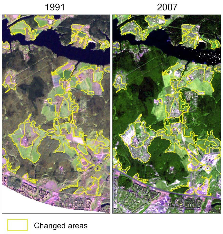
3 Results of the analysis Main characteristics of Moscow oblast s territory in 2002: the area of the whole territory without city of Moscow area was km 2 ( 100% ) the area occupied by railroads and paved highways 1.8% the area of settlements 10.1% the area of water objects, swamps - 5 % the area of forests % other territories which are not suitable for agriculture form 5.2% territories suitable for agriculture and occupied by grass vegetation or arable lands 31.8% of the whole area. Changes detected by 2011: Moscow oblast s area hadn t changed; The area of highways and railroads had increased by 10-20% because of broadening and reconstruction. The area of settlements and other urban territories increased about 30% and continue growing. The area of forests had decreased by 5% generally because of appearance of new glades inside the forest. In some districts of the region the area of shrub lands had increased. In some cases areas of herbaceous vegetation appeared on the place of forests; The area of water objects almost hadn t changed. In some cases new ponds had appeared but their area is less than 0,1% of the total area of water objects. Since 2002 a part of peatbogs s area had been used by gardening cooperatives; The area of other territories which are not suitable for agriculture almost increased by 20%. Big territories of forest, peatbog s and less agriculture were destroyed by fire in During the period from 2002 till 2011 areas of lands suitable for agriculture were decreasing about 18% in two different ways urbanization (90% of changes) and naturalization (10%): 1. The area of lands suitable for agriculture has generally reduced in favour of urbanized territories in the following way: lands in districts neighboring to Moscow (in a radius of 3-8 km) have decreased by 30-85%. Lands of Krasnogorskiy and Lyuberetskiy districts almost entirely are occupied by urbanized territories lands within borders of main cities (with more than 70 thousand citizens) have decreased by 30-60% % of lands adjacent to big lakes and reservoirs in a radius of 2-5 km are occupied by urbanized territories % of lands in a radius of km from Moscow are occupied by new urbanized territories. in the rest of Moscow region the area of lands used for agricultural purposes has decreased 5-7% because of appearance of new urbanized territories. 3
4 4


5 2. Some of areas suitable for agriculture were of non operating during this period and have naturalized to forest or shrub: In some districts because of cutting down forested territories area of lands suitable for agriculture has even increased: But as usual the cutes in the forest are used for new elite settlement. The good news is that this processes is very rare. 5