Chapter 6: Land Use/Land Cover
|
|
|
- Mildred McDowell
- 5 years ago
- Views:
Transcription
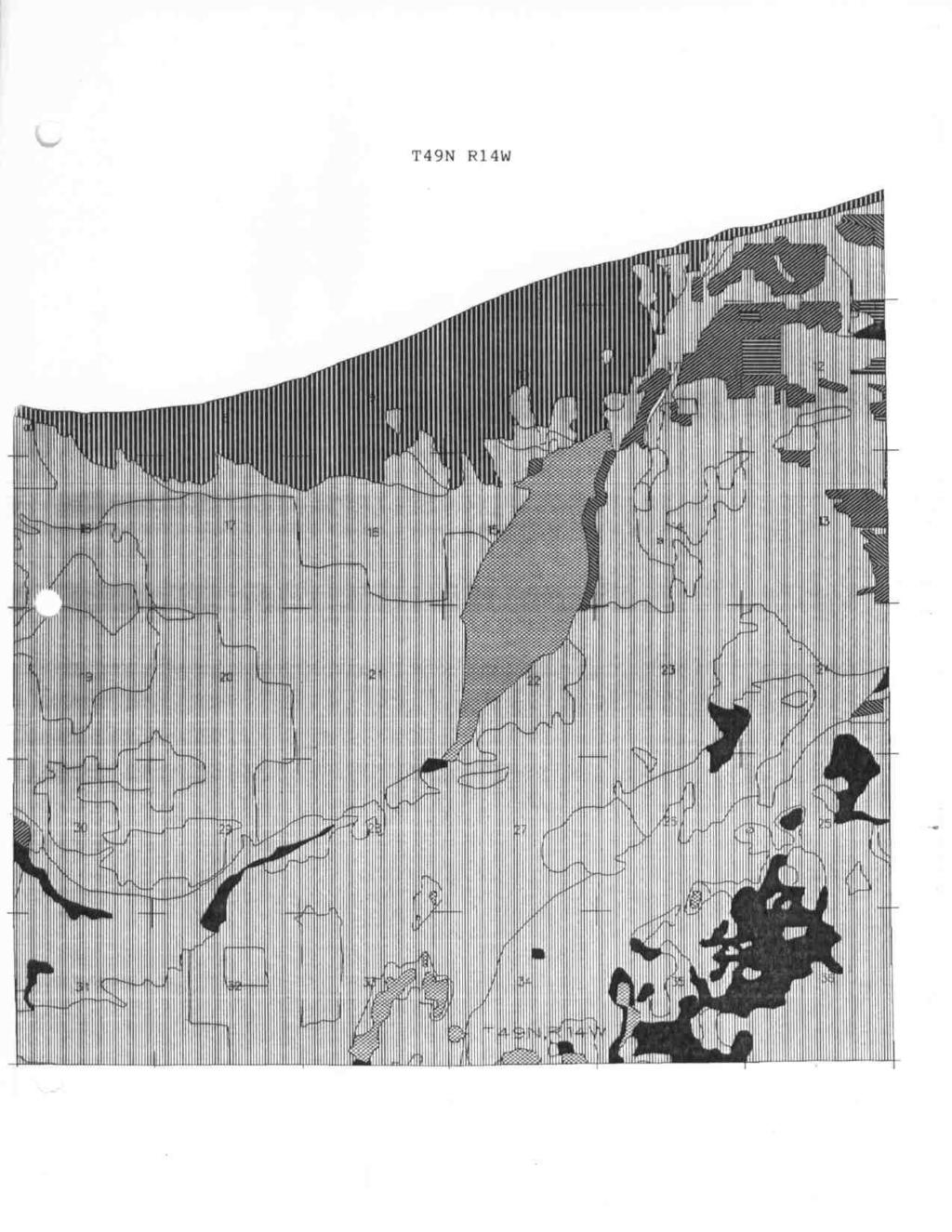
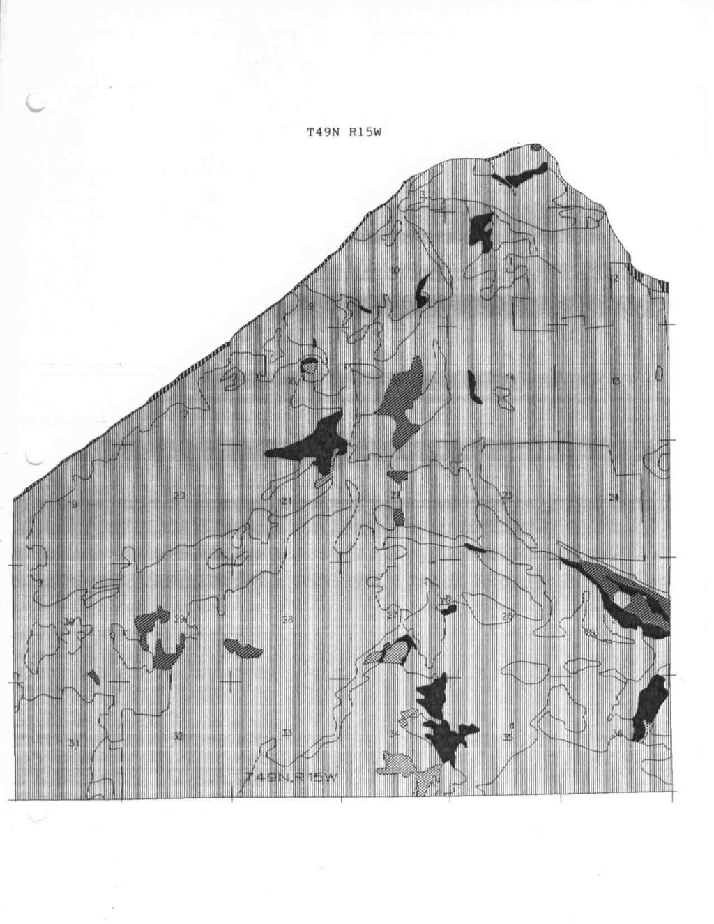
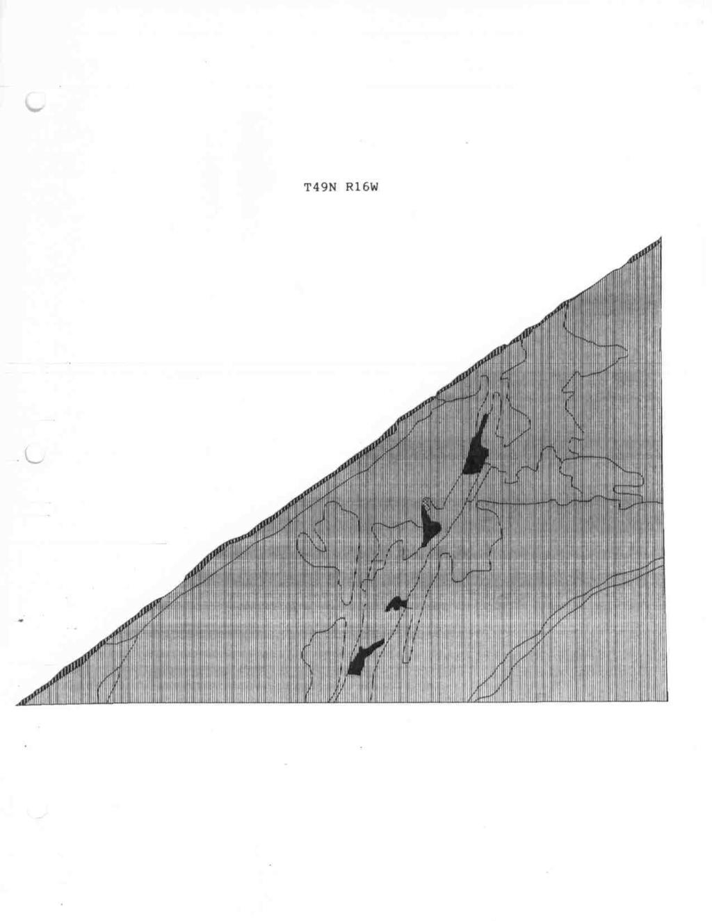
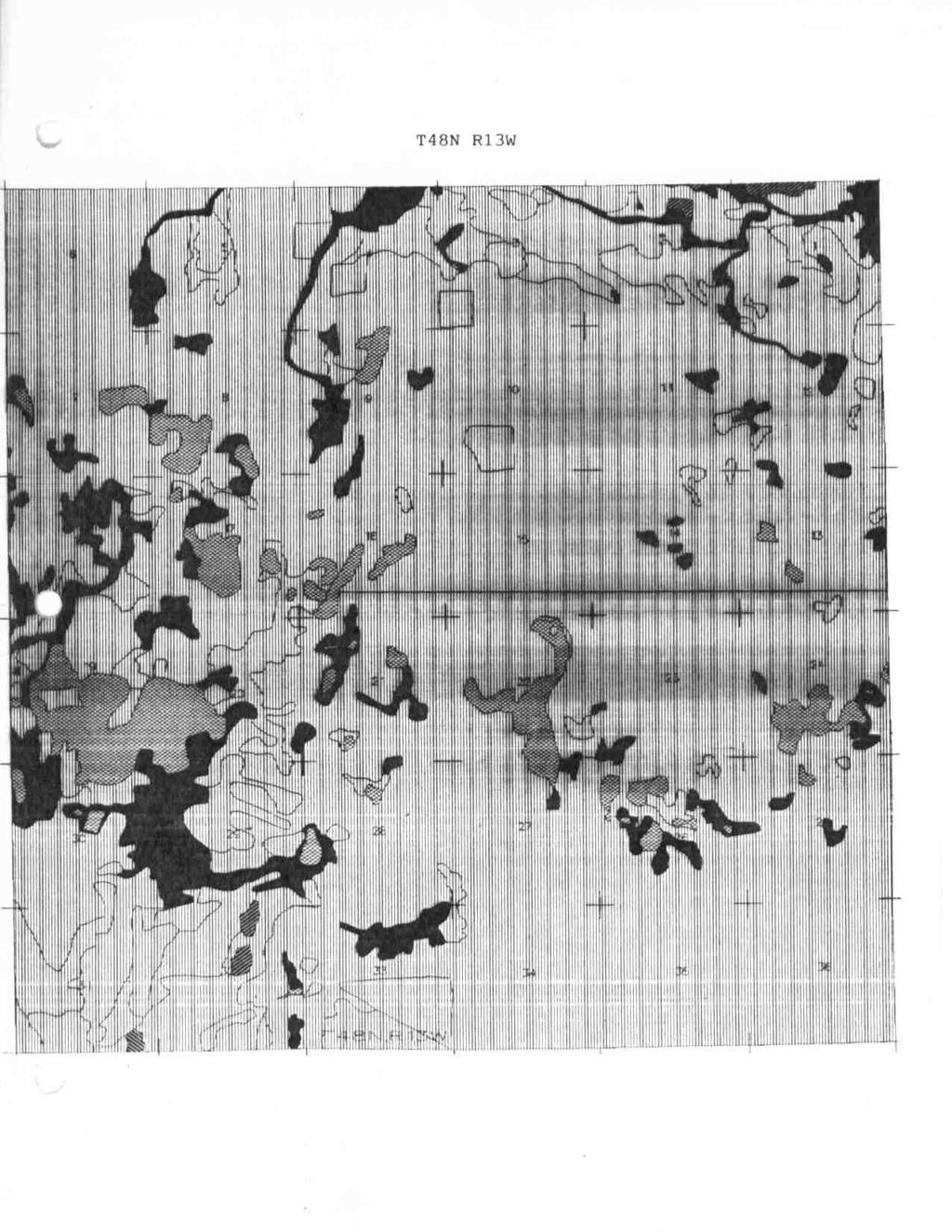
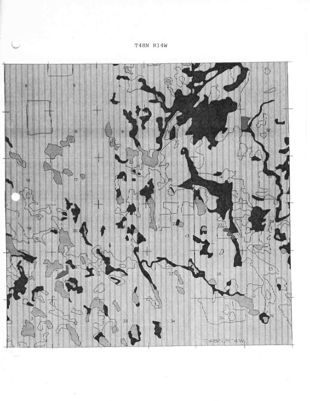
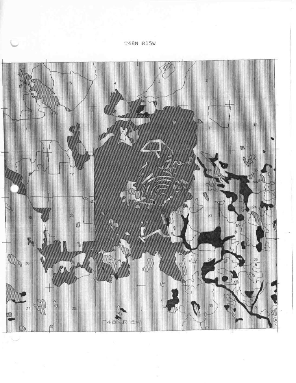
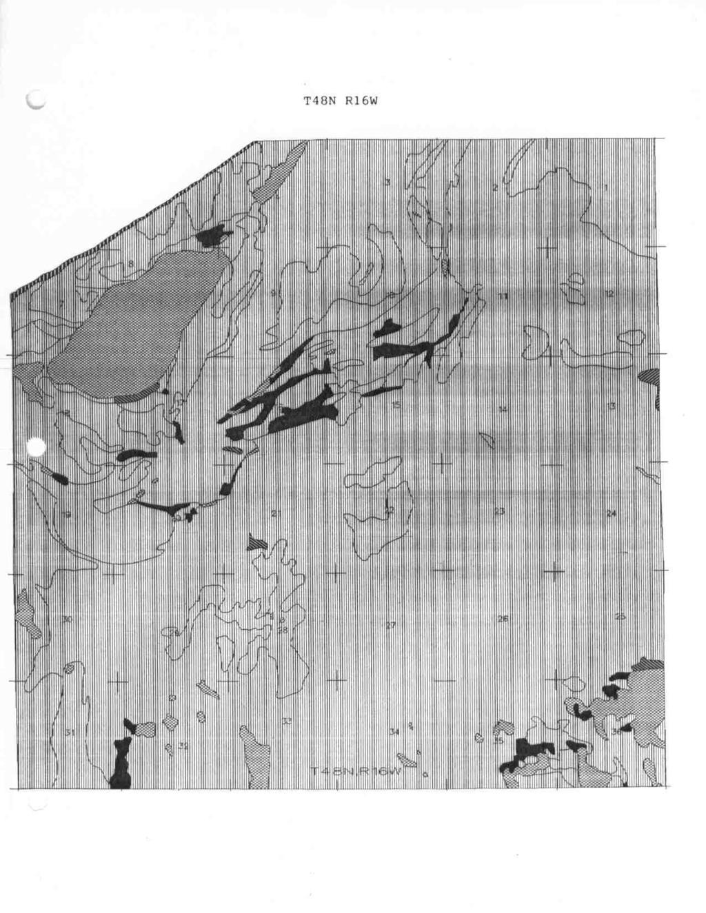
1 Chapter 6: Land Use/Land Cover The general historic land use pattern that emerged in Burt Township is similar to many other communities across the Upper Peninsula. Commercial fishing and lumbering were the two major economic forces which gave rise to the community of Grand Marais and the township. The Township s location on Lake Superior and the ability to provide a harbor of refuge were significant in the early settlement of the community. Forest is the primary land use in Burt Township, with forests covering about 83 percent of the land area. Agriculture and urban uses represent very small proportions of the township, and are generally concentrated in the area around Grand Marais. The broad categories of land use described in this section are based on the Michigan Resource Information System (MIRIS), which utilized 1978 aerial photography. The inventory mapped land uses as small as two or three acres, and is generally considered to be very reliable; however, the data was compiled using standard manual interpretation techniques, and was not field checked. Changes in land use since 1978 are not reflected in the inventory. Table VI-1 shows the various land uses for Burt Township, according to MIRIS. A brief description of each land use/land cover category follows, and the land uses are graphically depicted on Map VI-1, which accompanies this plan. In addition, at the end of this chapter there are some maps that illustrate land use in the township in greater detail. Table VI 1 Land Use/ Land Cover in Burt Township Burt Township Alger County Acres Percent Acres Percent Urban and Built Up , Single Family Institutional Industrial 66.1 < 0.1 Air Transportation Water Transportation Open Pit Extractive 42.9 < 0.1 Outdoor Recreation 16.4 < 0.1 Cemeteries Agriculture , Cropland Orchard 16.6 < 0.1 Non-forested/Open 8, , Herbaceous Shrub 8, Forest 127, , Upland Hardwood 84, Aspen, Birch 12, Lowland Hardwood 1, Pine 15, Other Upland Conifer 1, Lowland Conifer 11, Water 5, , Lake 5, Wetlands 8, , Forested 3, Shrub 4, Emergent Barren 2, < 0.1 Beach, River Bank Sand Dune 1, TOTAL 152, , Source: Michigan Resource Information System VI 1

2 Burt Township covers approximately 239 square miles or 152,754 acres, which is roughly onequarter of the land area of Alger County. Urban Lands These are areas of intensive land use in which much of the surface is covered by structures. Included are commercial and residential development, transportation facilities, and power and communication facilities, as well as areas such as mines and quarries, shopping centers, industrial and commercial complexes and institutional land uses.
3 Slightly less than on-half of one percent of the land area of Burt Township is classified as urban according to MIRIS. Specifically, the urban land uses were determined to be 0.49 percent or acres. The vast majority of these urban land uses are situated in and around the community of Grand Marais, however, some notable exceptions do exist including air transportation which accounts for the airport approximately three miles south of Grand Marais; single-family residences on Nevin and Beaver Lakes; and a few industrial uses (ie: sawmills) along M-77. Agriculture Lands Agricultural areas are those where the production of food and fiber is the dominant land use. Just over 100 acres of land are devoted to agricultural purposes in the township. Like most of the urban uses, these lands are primarily situated in the vicinity of Grand Marais. The agricultural land uses include small amounts of cropland and orchards, and account for less than 0.1 percent of the total land area of the township. Non-forested or Open Lands Non-forested land (open land, range land) is defined as areas supporting early stages of plant succession consisting of plant communities characterized by grasses or shrubs. In cases where there is obvious evidence of seeding, fertilizing or other cultural practices, these areas are mapped as agricultural. Areas dominated by grasses or shrubs, but which occur in marshes, flooded basins or bogs, are mapped under the appropriate wetland category. Approximately 5.7 percent of the township is classified as non-forested. Although this cover type is scattered throughout the township, a large amount is concentrated in the vicinity of the airport. Forestland Forestlands are lands that are at least 10 percent stocked by forest trees of any size, or formerly having such tree cover, and not currently developed for non-forest use. Forestlands are by far the largest land use/cover in Burt Township, accounting for just over 83 percent of the total area. Water Bodies The water category includes all areas which are predominately or permanently water covered. This category is divided into streams and waterways, lakes, reservoirs and the Great Lakes. It is probably the easiest category to identify and delineate from the aerial photographs. Water bodies that are vegetated are placed in the wetland category. Sewage treatment or water supply facilities are a basic part of the urban pattern are identified in the urban areas. Nearly 5,200 acres of Burt Township is classified as water. Wetlands If water is the easiest area to classify, wetlands are undoubtedly the most difficult. In the MIRIS inventory, wetlands are defined as areas where the water table is at, near or above the land surface for a significant part of most years. The hydrologic regime is such that aquatic or hydrophytic vegetation usually is established. This general category includes marshes, swamps, bogs, potholes, wet meadows and river overflow and land and shallow lakes and ponds with emergent vegetation. VI 3
4 Although wetlands exist in most areas of the township, there are more wetlands in the eastern portion than the western half. Wetlands are generally more prevalent away from Lake Superior, although there are some notable exceptions. Barren Lands Barren land is land of limited ability to support life with little or no vegetation. Land temporarily barren owing to human activities and where it may reasonably be inferred that the land will be returned to its former use is included in one of the other categories. Agricultural land temporarily without vegetation because of tillage practices is still classified as agricultural land. Sites for urban development stripped of cover before construction begins are classified as urban lands. Areas of extraction and industrial land having waste and tailings dumps are placed in the respective extractive and industrial category. The barren lands in Burt Township include the sand dunes and beach areas and account for 2,242.6 acres or 1.5 percent of the total land area. Factors Influencing Land Use Patterns A number of factors impact or determine how and when land is utilized. These can basically be broken into three broad categories: physical, legal and economic/location. The physical characteristics of the land influence, in many instances, how it will be used. These characteristics are weighed against economic and locational factors in many cases, and when the demand for certain types of property becomes high enough, it may be feasible to attempt to overcome physical constraints. There are many instances where land which would ordinarily be considered too steep, too sandy, too rocky or otherwise unsuitable for development has been developed because of its location, for example. Examples of physical factors which influence land utilization include soil types with poor drainage or high water tables, which are unsuitable for private septic systems; soils with low productivity for agriculture crops, which limit agricultural use; or steep slopes which may limit construction or logging activities. Existing adjacent land use, the proximity of services such as sewer or water, and the existing transportation system are other physical factors which influence land use. Legal factors which influence land utilization include zoning and other land use restrictions, and land ownership. Zoning places specific restrictions on the types of uses that are allowed on a parcel of land, and the conditions under which development may take place. Laws at both the state and federal level regulate development in wetlands, floodplains, areas of historic or archeological significance, etc., particularly when state or federal funds are used in the development. In Burt Township, for example, the Michigan Department of Natural Resources regulates development in dune areas, and the presence of piping plover nesting and foraging areas near Grand Marais limits certain types and seasons of use in and near those areas. Ownership also impacts how a parcel of land will be utilized. Zoning and other laws aside, the private owner of a parcel of property determines how and when a parcel will be utilized. In the case of public ownership however, there may be limitations and/or restrictions as to how the land can be utilized depending on which governmental agency owns the property. Location has a significant influence on the demand for certain types of development, such as residential or recreational development along a lakeshore, commercial establishments on a busy highway, or industrial sites near concentrations of natural resources. Economic factors, such as the demand for a natural resource (lumber, iron ore, etc.), rising or falling personal income, increased vacation and leisure time, increasing numbers of retired people, and housing demand also influence land use. VI - 4
5 There are of course other factors which ultimately influence land use patterns, but legal, physical and economic/locational considerations are key determinants in most cases. Land Ownership Significant portions of Burt Township are in public ownership, including the Pictured Rocks National Lakeshore and the Lake Superior State Forest. Benson Forest Products is also a large landowner in the township. Over 19,000 of the township s 152,754 acres are owned by the National Park Service. There are also lands of other ownership found within the buffer zone of the Pictured Rocks National Lakeshore. Land use within the Lakeshore will be in accordance with the Park Service s stated objective of managing for the perpetuation and protection of the natural environment and the preservation of cultural features while making them available for appropriate public use. (Pictured Rocks National Lakeshore General Management Plan, Sept., 1981). Legislation authorizing establishment of the Lakeshore stipulated that the area be made up of two management zones. Portions of both zones are located within Burt Township. The shoreline zone was to be acquired by the Park Service, while the inland buffer zone would remain largely in state and private ownership. Timber harvest is permitted within the buffer zone, although the legislation authorizes the Park Service to use eminent domain to acquire lands in order to halt uses that could be detrimental to lands within the shoreline zone. In 1985, the Park Service completed a plan which clarified permissible uses in the inland buffer zone, and identified lands which the National Park Service was interested in acquiring if available. The National Park Service has acquired acres of inland buffer zone land in Burt Township as of December 31, The Park Service worked with Burt Township and other local units of government to enact zoning for privately-owned lands within the inland buffer zone. The Park Service is presently preparing an Environmental Impact Statement for a proposed new road within the shoreline zone. If constructed, the new road would connect with existing roads, including H-58 and Newburg Road, to form a scenic shoreline drive. This new road would be located within the township, and improved access and associated paving and upgrading of roads could potentially affect traffic volumes and patterns in the township. The draft EIS is expected to be completed in mid Much of the remainder of the township is located within the boundaries of the Lake Superior State Forest, including over 29,000 acres of land owned by the State of Michigan. The primary land uses in this area are forest producti9on and outdoor recreation. Over 77,000 acres of land in the township previously owned by Cleveland Cliffs International Corporation is now owned by Benson Forest Products of Au Train. Some of these lands are located within the boundary of the Lake Superior State Forest. The primary land use is forest production. Contaminated Soil Two sites in Burt Township are included in the Michigan DNR s proposed list of sites of environmental contamination for The sites are the Alger County Road Commission Garage in Grand Marais (Site No ) and the Burt Township Dump east of Grand Marais (Site No ). VI 5

6 These sites represent the location of environmental contamination as defined by the Michigan Environmental Response Act, Public Act 307 of 1982, as amended. As defined by this act, environmental contamination means that release of a hazardous substance, or the potential release of a discarded hazardous substance in a quantity which is or may become injurious to the environment, or to the public health, safety or welfare. The contaminant at the Road Commission garage is road salt; at the dump site the contaminant is domestic solid waste. Both sites are listed as inactive, meaning no actions have been taken to remove the contamination. The Burt Township Dump has a Site Assessment Model (SAM) score of 20 on a scale of 0-48, with 48 points representing the highest risk. The Road Commission Garage has a SAM score of 12.
7
8
9
10
11
12
13
14