The Long-Term Perspective of Climate, Fire, and Water in the Southwest from Tree Rings Thomas W. Swetnam Laboratory of Tree-Ring Research, University
|
|
|
- Myra Howard
- 5 years ago
- Views:
Transcription


1 The Long-Term Perspective of Climate, Fire, and Water in the Southwest from Tree Rings Thomas W. Swetnam Laboratory of Tree-Ring Research, University of Arizona Jemez Mountains Tree-Ring Lab


2 2018 Wet years 1885 Dry years


3 3 Andrew Ellicott Douglass Founder of Modern Dendrochronology & Laboratory of Tree-Ring Research


4 What happened to the Cliff Dwellers? Why did they leave and where did they go? Pueblo Bonito, Chaco Culture National Historical Park Cliff Palace, Mesa Verde National Park Keet Seel, Navajo National Monument


5 5 Secrets of the Southwest Solved by Talkative Tree Rings, by A. E. Douglass, National Geographic magazine, December 1929 The great drouth of 1276 to 1299 was the most severe of all those represented in this 1,200 year record and undoubtedly was connected with extensive disturbances in the welfare of the Pueblo people. AED
6 Courtesy of David Stahle

7 Drought sensitive tree-ring width chronologies are calibrated with instrumental-based records of Summer Palmer Drought Severity Index, and interpolated to an evenly spaced grid network. Cook, E.R., C.A. Woodhouse, C.M. Eakin, D.M. Meko, D.W. Stahle. Science 306: Nov


8 Calibration/Verification Reconstruction Very Wet! Data from Cook et al. Science 306: Nov , graphic courtesy of David Stahle

9 Woodhouse, C. A., & Pederson, G. T. (2018). Investigating runoff efficiency in upper Colorado river streamflow over past centuries. Water Resources Research, 54,


10 Tree-Ring reconstruction of 1,200 years of Colorado River flow Meko, Woodhouse and others, 2007 The general picture of a collision between water demand and supply in the Upper Colorado River Basin in the not-too-distant future is all too apparent. Stockton and Jacoby 1976


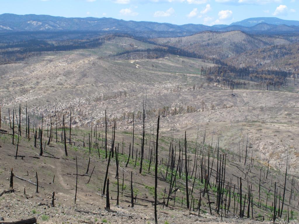
11 Fire-scarred trees record the history of forest fires within their tree rings. In the western US they typically show that frequent fires occurred before circa 1900, then abruptly ceased with the advent of livestock grazing and fire fighting by government agencies. 11


12 The Western North American fire scar network now includes more than 800 tree-ring based fire scar chronologies.

13 The combined record of fire occurrence from more than 800 sites shows relatively high fire frequency prior to circa 1900, and a high degree of synchrony in both large and small fire years. These regionally synchronous patterns are well-correlated with dry/wet conditions.
 with Percentage of Sites Scarred Per Year over the region as well as modern Area Burned.")
14 Drought Area Index over the Western US is significantly correlated (r=0.51, p<0.01) with Percentage of Sites Scarred Per Year over the region as well as modern Area Burned. Largest and Smallest fire years are also strongly linked to wet/dry patterns over this 3 million km 2 region. Drought Area Index Year

15 Encebado Fire, 2003
16 The Las Conchas Fire, near Los Alamos, New Mexico burned > 40,000 acres during the first 15 hours. For some hours in late afternoon it burned as a paired, counter-rotating, horizontal roll vortex fire. Las Conchas Fire, June 26, 2011
17

18 Photo courtesy Craig Allen

 doi:10.")
19 Extreme water quality degradation following a catast rophic forest fire. Dahm et al. Freshwater Biology (2015) doi: /f wb.12548
20 Dissolved oxygen levels in the Rio Grande at the Hwy 550 bridge, Bernallilo, NM, following the Las Conchas Fire in 2011 (red line). Average conditions in previous years shown in black line. Dahm et al. 2015

21 Wildland Urban Interface University of Wisconsin


22 How did Puebloan people live within drought and fireprone forests and woodlands of the Southwestern United States for multiple centuries? Kwastiyukwa in Jemez Mountains, approx. 1,500 rooms, 3 to 4 stories, occupation ca CE

23 The Southern Jemez Plateau in northern New Mexico sustained 8,000 to 5,000 people living within a 40,000 ha forested area from circa 1400 to 1620 AD. At least 10 villages had 500 to 1,500 rooms each, and 3 to 4 story stone masonry buildings. The surrounding landscape today is forested with ponderosa pine, pinyon pine and juniper trees.

24 Liebmann, M.J., J. Farella, C.I. Roos, A. Stack, S. Martini, and T.W. Swetnam Native American depopulation, reforestation, and fire regimes in the Southwest United States, CE. Proceedings of the National Academy of Sciences 113 (6) E696-E704
. Liebmann et al.")
25 By sampling and tree-ring dating trees that established on village ruins following de-population we estimated the timing of last major use of the village sites, i.e., terminus ante quem (a limit before which). Liebmann et al
26 1521 Smallpox in Mexico 1541 First Contact 1598 Oñate Liebmann et al s Missions established at Giusewa and Walatowa

27 Franciscan friar Geronimo Zárate Salmerón stated that he baptized 6,566 souls at Giusewa in the 1620s.

28 The combined fire scar record over the entire Jemez Mountains shows a clear pattern of reduced widespread fires during the period prior to the 1680 Pueblo Revolt. Many fires occurred during the pre-1680 period, but they were relatively small fires. Swetnam, T.W., J. Farella, C.I. Roos, M.J. Liebmann, D.A. Falk and C.D. Allen Multi-Scale perspectives of fire, clim ate and humans in western North America and the Jemez Mountains, U.S.A. Philosophical Transactions of the Royal Soci ety B. 371:


29 or If you would like to read more

 of")
30 Forest thinning with chain saws and other mechanical equipment can effectively restore the historical tree densities (numbers/area) of forests. Before After


31 The most effective fuel treatments and long-term maintenance of healthy, resilient ponderosa pine forests includes the use prescribed fire.


32

33 Fire adds richness to the land Paul Tosa,
34 TREE-RING RESEARCH, Vol. 71(2), 2015, pp DOI:
35 Toby R. Ault, and Scott St. George. Unraveling the mysteries of megadrought Physics Today. Vol 71, 8, 44 (2018); doi: /PT


36 354 Tree-Ring Width Site Chronologies calibrated with warm season vapor pressure deficit and cool season precipitation to produce a Forest Drought Stress Index. A. Park Williams, et al. March 2013, Vol 3(3).
37 Measurements of forest productivity and mortality overlaid on the Forest Drought Stress Index (red, right y axis). Vegetation Greenness (satellite observations) Percentage Standing Dead Trees by Species Area with >10 Trees/Acre Killed by Beetles Area of Forest & Woodland with Moderate & Severe Burn (satellite obs.)


38 Based on downscaled global circulation model outputs, by 2050 average Forest Drought Stress Indices in the Southwest will be as low or lower than during the worst droughts of the past millennia. Williams et al. Nature Climate Change 2013.