A Comprehensive Approach to Urban. Photo: Chris Doolittle
|
|
|
- Shon Hampton
- 5 years ago
- Views:
Transcription

1 A Comprehensive Approach to Urban Wildfire Losses in California Jon E. Keeley 1,2, Alexandra D. Syphard 3, Teresa Brennan 1, C.J. Fotheringham 1 1 U.S.. Geological Survey, Sequoia National Park, CA 2 University of California, Los Angeles, CA 3 Conservation Biology Institute, La Mesa, CA Photo: Chris Doolittle
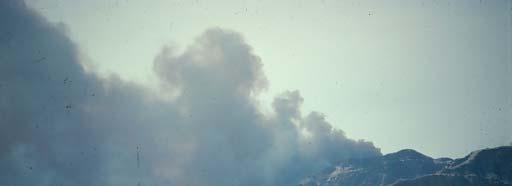
2 "The hazardous mediterranean climate, highly flammable vegetation, and rugged terrain, all important elements of fire behavior, become problems only in the presence of people. People recreate and build homes in the mediterranean wildlands because of the delightful climate and will continue to do so as long as space is available. People start most fires, and their mere presence tends to warp fire suppression strategies because fire agencies must protect lives and property threatened by fires rather than 'back off' and build fire lines around fire perimeters." Carl C. Wilson (1979) USFS Chief of Forest and Fire Research Photo: LA Times
3 Pop Fire size Losses #/km 2 Year (ha) Structures Lives Mediterranean Portugal , Greece , California northern southern , Chile 21 S. Africa Cape Australia Western Aus , Victoria , NASA
4
5
6
7 NUMBER AREA Fire Frequency and Area Burned (%) Santa Ana Wind (days) Image: NASA 0 J F M A M J J A S 0 N D Month
8
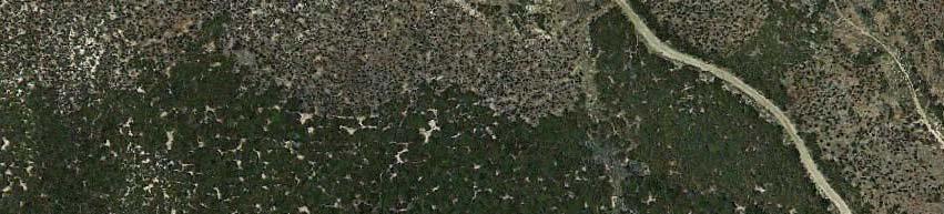
9 Image: Google Earth
10 Wildland-Urban Interface USGS Fire Risk Scenario Can we alter future fire outcomes? Image: Google Earth
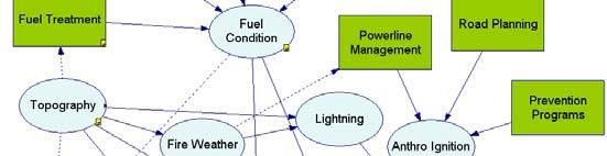
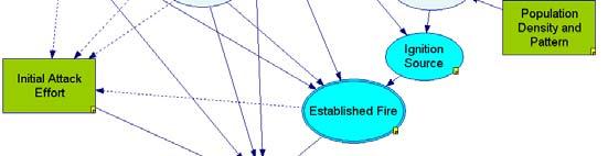
11 Damage risk Is a function of wildland and urban factors: D = f (I, S, E, G, H) I = P a fire starting in the landscape S = P of fire reaching the urban environment E = P of it encroaching into the urban environment G = P of fire propagating within the built environment H = P of home destruction, given an urban fire Image: Google Earth


12 I = P a fire starting in the landscape S = P of fire reaching the urban environment E = P of it encroaching into the urban environment G = P of fire propagating within the built environment Image: Google Earth H = P of home destruction, given an urban fire


13


14
15


16 The Role of Fuel Breaks in SoCal NFs National Forests Syphard, Keeley, and Brennan Forest Ecology and Management 2011 International Journal of Wildland Fire 2011


17 What is the role of fuel breaks in controlling large fires & what factors influence this role? GIS overlay and analysis Personal interviews
18 Effective during normal weather or to control flanks Unsafe and ineffective during most Santa Ana events Embers can fly kilometers ahead of fire front Not Stopped Stopped P roportion of intersections 0 Jan Feb March April May June July August September October November December


19 The Role of Fuel Breaks in Southern CA National Forests Most fires don t encounter a fuel break Fires either stopped or were controlled by firefighters ~ 50% of encounters -2007) f Fires (1980- Number of Intersect No Intersect ANF LPNF SBNF CNF
20 Outcome Results, 3 Forests Most important: Access, Fire size, Condition of FB > 95% were controlled but fires rarely stop on their own Variation among forests * Significant all 3 forests * * * LPNF ANF SBNF Distance trails t * * Fire size Fire season Fuel break condition n Fuel break length Access Resources Elevation Slope Solar radiation Vegetation age Distance road Distanc nce development Percent Deviance Expl lained


21 Aerial Views of Mastication N ½ mile N ¼ mile Corte Madera Mastication Spring Cleveland National Forest Lone Pine Mastication Winter San Bernardino National Forest


22 Aerial Views of Crushing N ½ mile N ¼ mile Leona Divide Crushing, Angeles National Forest Leona Divide-Crushing,2008 & Mastication 2009 Angeles National Forest
23
24
25 What About Effectiveness of Mechanical treatments: Proximal impact: Reduce flame lengths Ultimate impact: During severe fire weather conditions, treated areas generally do not provide barriers to the fire front, but are sometimes valuable for controlling flanks Under moderate weather conditions fires may stop at fuel treatments, or provide defensible space for backfires but not always and this is an area in need of further research. East Camino Cielo Mastication Treatment, Los Padres National Forest
26 USGS Fire Risk Scenario Fuel treatments Suppression Zoning Planning Image: Google Earth Urban structure & landscaping
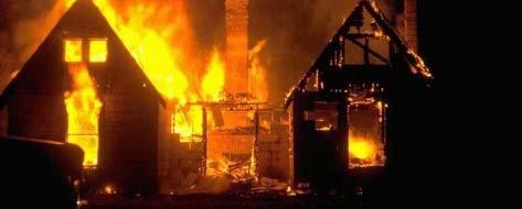
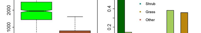
27 Factors driving housing losses: 36,399 / 313 Santa Monica 687,869 / 5,230) Mountains San Diego County


28 Calfire Hazard Maps High Low Structures unaffected by wildfire Structures destroyed Syphard et al. 2012
29 Syphard et al. 2012
30 Land Use Planning Syphard et al. 2012, PLoS ONE Syphard et al. 2007, Ecological Applicati Syphard et al. 2009, Conservation Biolo


31 USGS Fire Risk Scenario Fuel treatments Suppression Zoning Planning Image: Google Earth Urban structure & landscaping
32
33
34
35 Defensible Space (Syphard, Brennan, Keeley in review)


36 Defensible Space Low slope properties P < P = 0.14 High slope properties 07 P < ,6 0,5 stroyed 0,4 03 0,3 Proporti des on of homes 0,7 0,2 0,1 0 P = feet25 50 feet feet feet 299 feet feet
37
38 Image: Google Earth
39


40 Image: Google Earth
41 What does the future hold? Climate change? In southern California i we need to think more broadly in terms of global changes >99% of all lands are burned by human-ignited fires In the next several decades populations will increase by more than 50% while temperatures are predicted to increase 2-3%


42 U.S. Forest Service USFS Cal Fire
43 Sierra Nevada region 5. Sierra Nevada ) El Dorado NF Stanislaus NF Inyo Mono NF Sierra NF Sequoia NF 5. Amador San Joaquin Calaveras Stanislaus Tuolumne Mariposa Merced Madera Inyo Mono Fresno Kings Tulare Kern 5. Sierra Nevada El Dorado


44
45 Winter A) USFS 5.0 Spring Winter B) Cal Fire 5.0 Spring 4.2 rea burned (log ha / million ha) Ar r 2 = 0.00 r 2 = 0.15 P = P < Summer Autumn Ar rea burned (log ha / million ha) r 2 = 0.00 r 2 = 0.00 P = P = Summer Autumn r 2 = 0.12 r 2 = 0.00 P < P = Average temperature ( o C) Average temperature ( o C) r 2 = 0.01 r 2 = 0.00 P = P = Area burned (lo og ha / million ha) Winter A) USFS Spring r 2 = 0.04 r 2 = 0.22 P = P < Summer Autumn r 2 = r 2 = 0.00 P = P = Precipitation (mm) Area burned (log ha / million ha) Winter B) Cal Fire Spring r 2 = 0.00 P = r 2 = 0.01 P = Summer 5.0 Autumn r 2 = r 2 = P = P = Precipitation (mm)
46 California 120 USFS 350 CalFire Area burned (1000-ha / million ha) r 2 = 0.62 P = Area burned ( ha / milli ion ha pro otected) r 2 = P = Decade Decade 9Keeley & Syphard in preparation)
47 Year Fire County Month Acres Santiago Cyn Orange Sept 308, Matilija Sta Barbara Sept 219, Laguna San Diego Sept 174, Wheeler #2 Ventura July 122, Cedar San Diego Oct 270, Day Ventura Sept 161, Zaca Sta Barbara July 240, Witch San Diego Oct 198, Station Los Angeles August 166,600
48 Drought (Keeley & Zedler in press)
49 Image: NASA

")
50 Drought (Keeley & Zedler in press)


51 Acknowledgments MHDP USGS Hazards Project Photo: JE Keeley