Potentially Trackable Small Patch Communities of the Maybelle Dunes, Richardson River Dunes and Marguerite Crag and Tail Wildland Parks
|
|
|
- Angel Wilkinson
- 5 years ago
- Views:
Transcription
1 Potentially Trackable Small Patch Communities of the Maybelle Dunes, Richardson River Dunes and Marguerite Crag and Tail Wildland Parks Lorna Allen and J. Derek Johnson Introduction Natural plant communities are defined as recurring assemblages of plant species; the species occurring together because they respond similarly to a variety of site attributes 1. They occur at different scales. Some, termed matrix communities, 2 are widespread and cover large areas across the landscape. Large patch communities are less extensive and cover less of the landscape, but overall may still form large, uninterrupted patches. Together, matrix and large patch communities usually make up the main, representative vegetation of an area. Small patch communities form small, discrete areas, usually associated with specific, specialised habitats, such as cliff faces. They may be correlated to some unusual attribute such as saline seepage. Work to characterise the vegetation of a study area generally concentrates on matrix and large patch communities as the representative types that are common or spread over large areas. Small patch communities are overlooked specifically because they are not extensive enough to be considered representative. However, small patch communities may add significantly to the biodiversity of a site. They may contain a disproportionately large percentage of the total flora, and also support a specific and restricted set of associated fauna (e.g. invertebrates or herpetofauna) dependent on specialized conditions 2. However, plant communities are not just containers for species but complex dynamic systems in themselves 2. Documenting these small patch plant communities then is important in documenting the biodiversity of protected areas. Both as elements of biodiversity themselves that may be rare or unusual, and as specialised habitats that potentially harbour species not yet documented. Methods The focus of this work was to collect information on small patch communities in three recently established wildland parks in and at the edge of the Athabasca Plains Subregion of the Canadian Shield Natural Region of Alberta. These are the Maybelle River, Richardson River Dunes and Marguerite Crag and Tail wildland parks. Although the information presented here will supplement the information on representative vegetation being collected by the Ecological Land Classification team, emphasis was placed on documenting communities that may be significant in a provincial context. 1
2 A review of the literature for sites with similarities to the wildland parks and for sites in northeastern Alberta, northwestern Saskatchewan and the nearby Northwest Territories was done. Any plant communities or habitats that have been documented as unusual in any way were noted as community types of interest that potentially occur within the wildland parks. Wherever possible these potential types were linked to landscapes that could be picked out on aerial photographs. The potential types and target landscapes are listed in Appendix 1. In addition, the Alberta Natural Heritage Information Centre Preliminary Plant Community Tracking List 3 is a compilation of plant communities thought to be of restricted distribution in the province. Although none on the current list are specific to the Canadian Shield Natural Region, it is possible that some of those known to occur in the Boreal Natural Region may be found in the study areas. Again, these were identified and linked to a landscape, as listed in Appendix 2. In total, 26 unusual communities or habitats were identified as potentially occurring within the study areas and linked to landscapes. Aerial photographs for each of the three wildland parks were then reviewed and any landscapes with potential to include these unusual communities were marked as target areas. As many target areas as possible were visited during the field program. When a plant community that might be unusual was encountered, a vegetation plot was subjectively placed in a homogeneous location. Site data and floristic composition was documented and the cover of each species noted. For sites with complex lichen mixtures, all lichen species were noted, but individual covers were not assigned. Instead, an overall lichen cover was estimated and the main species assigned relative dominance. Plot sizes were chosen appropriate to the physiognomy of the vegetation being documented. Results Table 1 summarises the targeted landscapes that the literature suggested may include some unusual community types. No rocky shorelines, saline seepage areas, shrubby forest openings or Larix fens were located during the aerial photograph review. Locations for all other target landscapes were found on the aerial photographs, however due to timing and logistic constraints, not all were visited. No patterned wetlands, sharp river breaks or large conifers on stabilised dune ridges were inspected. 2
3 Table 1. Target Landscapes General Target Landscapes Observations Landscape Uplands Open graminoid slopes Graminoid slopes located and documented (Carex siccata slope) Shrubby forest openings No sites located on aerial photographs Aspen stands Stands visited, no unusual types noted Vegetated Dune blow outs with No sites inspected Dune Areas conifers Open pine stands One stand documented (Pinus banksiana / Cladina) Open sandy knolls Unusual dwarf shrubland documented (Hudsonia tomentosa lichen crust) Large conifers on stabilised No sites inspected dune ridges Active Dune Areas Gravel areas between active dune ridges Gravel areas visited, no vegetated ones located Riparian Spruce stands Stands visited, no unusual types noted areas Deciduous stands One stand documented (Betula papyrifera / Vaccinium vitis-idaea) Shrublands Stands visited, no unusual types noted Sharp river breaks No sites inspected Wetlands Sandy shorelines Sites visited, no unusual types noted Rocky shorelines No sites located on aerial photographs Shorelines with Phragmites No stands documented Saline seepage No sites located on aerial photographs Small graminoid wetlands among dunes Two communities documented, (Chamaedaphne Kalmia / Cladina and Carex oligosperma / Sphagnum) Beaver ponds Vegetation too immature to document communities Larix fen No sites located on aerial photographs Patterned fen No sites inspected Some landscape types visited did not support plant communities that were considered unusual. Although in some cases they were a restricted community within the particular wildland park, they were similar to more widespread types and so were not documented in detail. 3
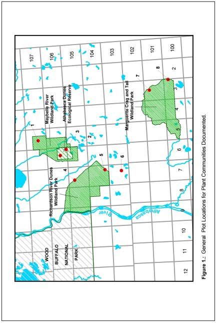
4 One beaver pond was inspected that likely included the community on the tracking list Carex pseudo-cyperus - Calla palustris, currently ranked S1S2. A seed head left over from a previous year permitted confirmation that Carex pseudo-cyperus was present, however, the sedges were too immature to document the community in detail. Another community on the tracking list, Phragmites australis, appears to be frequent around lakes in northeastern Alberta. None were sampled on the ground, but some observations were made. In her work to locate rare plant species, Joyce Gould documented two occurrences of an unusual fen type (Andromeda polifolia - Sarracenia purpurea poor fen). Those plant communities located that were potentially significant in a provincial context were documented through plots. Other types were just noted. Plant Communities Documented Seven plant community types (CT) of potential significance were documented in detail. The general locations of the plots are given in Figure 1 and listed beside each type. The types documented include: two forest/woodland communities CT 1. Betula papyrifera / Vaccinium vitis-idaea (Site 4) CT 2. Pinus banksiana / Cladina mitis (Site 8) three shrublands CT 3. Andromeda polifolia / Sarracenia purpurea Sphagnum angustifolium poor fen (Sites 3, 4 &7) CT 4. Chamaedaphne calyculata Kalmia polifolia / Cladina mitis (Sites 4 & 5) CT 5. Hudsonia tomentosa / lichen crust on sand (Site 5) and two herbaceous communities CT 6. Carex oligosperma - Sphagnum subsecundum poor fen (Sites 4 & 5) CT 7. Carex siccata graminoid slope (Sites 1 & 3) For each of these, detailed information collected is presented followed by a discussion, evaluation as to the community s significance and brief recommendations. 4
5 5

6 CT 1. Betula papyrifera / Vaccinium vitis-idaea Location (Figure 2) Maybelle River Wildland Park 12V UTM (June 18, 2000) Site Description A mature stand of birch on a leading dune edge, at the eastern edge of the main dunes. The plot is located mid-slope on a strongly sloping (25 ) north-east facing dune in a protected pocket with a subxeric moisture regime on rapidly drained sand. photo by Drajs Vujnovic Comments This is a stand of mature birch with a closed canopy and open understory. There is a dense layer of leaf litter, covering about 75% of the ground in the plot. A small amount of exposed sand is present (1% cover) from small mammal burrows. Although the plot was done on the slope, the stand continues onto the flats at the base of the slope. On the flats, Vaccinium myrtilloides becomes more prevalent and Cypripedium acaule is present. 6
7 Plot: 10 X 20 m plot (20 m side following the contour of the slope) Species Cover (%) Scientific Common Trees Betula papyrifera white birch 50 Pinus banksiana jack pine + Shrubs Prunus pensylvanica pin cherry + Vaccinium myrtilloides common blueberry 5 Herb, Dwarf shrub Aralia nudicaulis wild sarsaparilla 2 Arctostaphylos uva-ursi bear berry 5 Chimaphila umbellata prince s-pine 1 Maianthemum canadense wild lily-of-the-valley 2 Geocaulon lividum northern bastard toadflax 1 Trientalis borealis northern starflower + Vaccinium vitis-idaea bog cranberry 50 Mosses Rhacomitrium canescens grey moss + Lichens Cladina mitis green reindeer lichen + Surveyor: L. Allen Discussion Most white birch stands noted in the study areas were B. papyrifera / Vaccinium myrtilloides communities. A Betula papyrifera / Vaccinium vitisidaea / Cladina mitis type was noted as a rare type in the Andrew Lake area 4, but this was a mesic community with Picea mariana prominent in the understory and Alnus crispa present (4% cover). No other similar white birch stands were noted in the literature. Significance White birch stands were not uncommon in the study areas, but generally occurred as small patches, often in subxeric to mesic locations. Landals 5 noted that aspen and birch stands tended to be found in similar habitats; in depressions and where drainage provides mesic soil conditions or along lake edges where the water table is high. More work is needed to describe the types that may be present. Current information suggests that 7

8 there may be one or more types that are restricted to this region of Alberta. Recommendation Although not uncommon in the study areas, there may be one or more white birch communities that are restricted to this region of the province. Further work is needed to document the birch community types present and to evaluate their significance. 8

9 CT 2. Pinus banksiana / Cladina mitis Location (Figure 3) Marguerite River Wildland Park 12V UTM (June 14, 2000) Site Description A community of vegetated sand plains. The stand is located on a xeric, rapidly drained site on level terrain. photo by L. Allen Comments The jack pine cover is sparse, only about 1% in the stand studied. There are a few scattered, old trees and some saplings (about 2 m tall) coming up. The presence of downed, burnt logs suggests that the old trees may have survived a fire. The shrub and herb layer is essentially lacking, although there are a few thicker patches of Vaccinium myrtilloides and the occasional Picea glauca (about 1 m tall). 9
10 Plot: a north / south transect through the community with a 1 X 1 m plot every 5 meters Species Cover (%) Scientific Common Trees Pinus banksiana jack pine 1 Picea glauca white spruce + Shrubs Vaccinium myrtilloides common blueberry 2 Herb/Dwarf shrub Arctostaphylos uva-ursi bearberry 3 Hudsonia tomentosa sand heather + Lycopodium complanatum ground cedar + Maianthemum canadense wild lily-of-the-valley + Melampyrum lineare cow-wheat + Vaccinium vitis-idaea bog cranberry + Graminoids Carex siccata hay sedge + Carex tonsa bald sedge + Oryzopsis pungens northern rice grass + Mosses Dicranum undulatum wavy dicranum + Polytrichum piliferum awned hair-cap + Lichens Cladina mitis green reindeer lichen 1* Cladina stellaris 3* Cladonia phyllophora + Cladonia gracilis + Cladonia cornuta + Cladonia cristatella + Cladonia deformis + Cladonia amaurocraea + Cladonia crispata + Cladonia botrytes + Cladonia borealis + Cladonia multiformis + Cladonia pyxidata + Cladonia subulata + Cladonia uncialis 2* Cetraria ericetorum + Flavocetraria nivalis + Stereocaulon condensatum + Stereocaulon tomentosum + Black lichen crust? Open sand 1 Geastrum floriforme flower-shaped earthstar + Epiphytes (on Vaccinium branches) Parmeliopsis ambigua Vulpicida pinastri 1*, 2*, 3* = first, second and third most common lichens 10

11 Surveyors: J.D. Johnson, L. Allen Discussion The transect was run through a stand chosen for its high lichen cover. With sparse tree cover, these lichen communities stood out on the aerial photographs. Although this particular stand was more open than most, there did not seem to be an appreciable difference in the understory when compared to the more closed stands with a high lichen cover. Landals 5 also found Cladina mitis and Cladonia amaurocraea as the dominant lichens under open pine in areas of stabilised sand. Significance Pinus banksiana / Cladina mitis is one of the more common communities in the region. For the area south of Lake Athabasca, Raup and Argus 6 consider the open jack pine / lichen forest to be the most common type on dry sites of stabilised dunes and sandy till plains. It is sensitive to disturbance, but not a significant type. Recommendation This is a common plant community in north-eastern Alberta, covering extensive areas. No special status is recommended. 11
 Maybelle River Wildland Park Plot 2 12V 0496726 6421218 NAD 27 (June 20, 2000) Site Description This community forms a band around the edges of small lakes.")
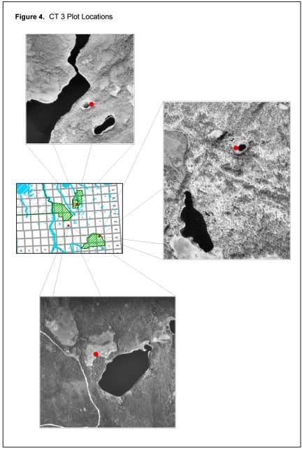
12 CT 3. Andromeda polifolia / Sarracenia purpurea / Sphagnum angustifolium poor fen Location (Figure 4) Marguerite River Wildland Park Plot 1 12V NAD 83 (June 17, 2000) Plot 2 12V NAD 83 (June 17, 2000) Maybelle River Wildland Park Plot 2 12V NAD 27 (June 20, 2000) Site Description This community forms a band around the edges of small lakes. The band varied in width from about 4 m to about 6 m at Plot 2. Photo by A.J. Gould Comments The high cover value of Sarracenia purpurea is striking. The stands appear similar, but plot three has a much greater cover of Andromeda polifolia and the Sphagnum species seem variable. 12
13 Plot: 2 X 2 m Species Cover (%) Scientific Common plot Herbs/Dwarf Shrubs Sarracenia purpurea Andromeda polifolia Chamaedaphne calyculata Kalmia polifolia 5 P - Drosera rotundifolia P - - Vaccinium oxycoccus P - - Eriophorum vaginatum P - 20 Smilacina trifolia - P - Mosses Sphagnum angustifolium Sphagnum magellanicum Sphagnum fuscum P = present Surveyors: A.J. Gould (plots 1, 2 & 3), J.D. Johnson (plot 1) Discussion This community type forming narrow rings around small lakes. No communities dominated by Sarracenia or Andromeda were found in the literature. Significance This appears to be a provincially rare plant community type. Two occurrences were documented, one in the Maybelle River Wildland Park and one in Marguerite River Wildland Park but it is likely that there are several more locations in both. Recommendation This community type should be recognised as a special feature of provincial significance. It should be recommended for addition to the Alberta Preliminary Plant Community Tracking List, proposed rank S1S2. 13
14 14
 Site Description This community occurs on sand in shallow depressions or channel drainages.")
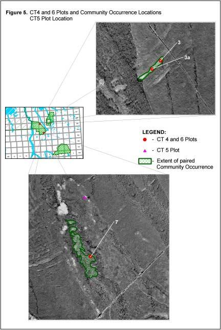
15 CT 4. Chamaedaphne calyculata Kalmia polifolia / Cladina mitis Location (Figure 5) Richardson River Dunes Wildland Park Plot 3 12V UTM (June 15, 2000) Plot 7 12V UTM (June 20, 2000) Site Description This community occurs on sand in shallow depressions or channel drainages. Occurrences may be in the centre of the depression (plot 7), or may form a band along the drainage (plot 3 and another occurrence noted at 12V UTM , but detailed notes not made). When forming a band along drainages, this community was adjacent to another unusual community type, the Carex oligosperma / Sphagnum subsecundum channel fen on sand. In all sites examined, the water table is very near the surface, and the community is likely subject to periodic flooding. photo by L. Allen 15
16 Plot: 5 X 5 m Species Cover (%) Scientific Common plot 3 7 Trees/Shrubs Pinus banksiana jack pine 10 1 Chamaedaphne calyculata leatherleaf Kalmia polifolia northern laurel 5 5 Ledum groenlandicum common Labrador tea - + Salix spp. willows - + Hudsonia tomentosa sand heather + - Vaccinium myrtilloides common blueberry + 2 Graminoid Carex oligosperma few-seeded sedge - + Mosses Polytrichum piliferum awned hair-cap P P Lichens Cladina mitis (1*) green reindeer lichen P P Cladonia gracilis (2*) P P Cladonia cornuta P P Cladonia cristatella P P Cladonia deformis P P Cladonia amaurocraea P - Cladonia crispata P P Cladonia botrytes P - Cladonia borealis P P Cladonia uncialis - P Cladonia/Cladina total cover Diploschistes muscorum P P Black lichen crust P P Open sand 5 1 Epiphytes (on ericaceous shrubs) Parmeliopsis ambigua Vulpicida pinastri *1, *2 = first and second most common lichens P = present but individual species cover not estimated Surveyors: J.D. Johnson, L. Allen 16
17 Comments Pine cover in this community type is always open, but can be variable. The trees are generally fairly small (maximum height 2.5 m, average 1.5 m tall at plot 3). The main lichen is Cladina mitis with Cladonia gracilis having the second greatest cover. Discussion This appears to be an unusual community type, forming on a specific habitat sand substrate with seepage at or near the surface. It was only documented in the Richardson River Dunes Wildland Park, but likely also occurs on suitable habitat in the vegetated dunes area of the Maybelle River Wildland Park. It was often found paired with CT 6, the Carex oligosperma Sphagnum subsecundum poor fen. Significance This appears to be a provincially rare plant community type. Three occurrences are documented to date, but it is likely that there are several more locations in both Maybelle River and Richardson River Dunes Wildland Parks. Recommendation This community type should be recognised as a special feature of provincial significance. It should be recommended for addition to the Alberta Preliminary Plant Community Tracking List, proposed rank S1S2. 17
18 18

19 CT 5. Hudsonia tomentosa / lichen crust on sand Location ( see Figure 5) Richardson River Dunes Wildland Park 12V UTM (June 13, 2000) Site Description This community was found on a southwest-facing slope near the head of a parabolic dune in an area with scattered jack pine and some active sand. It was found on the upper slope of a sand ridge and is likely subject to wind and water erosion. It is a xeric, rapidly drained site. photo by L. Allen Comments This appears to be an early successional community on sand. Charcoal was noted, evidence of past burns. The site is subject to wind and water erosion, with some of the crust areas undergoing deflation. 19
20 Plot: 5 X 5 m Species Cover (%) Scientific Common Shrubs Pinus banksiana jack pine + Herb/Dwarf shrub Hudsonia tomentosa sand heather 40 Solidago spathulata mountain goldenrod + Mosses Ceratodon purpureus purple horn-toothed moss 1 Polytrichum piliferum awned hair-cap 5 Lichens Cladonia + Diploschistes muscorum Grey lichen crust 10 unknown Black lichen crust 15 Geastrum floriforme flower-shaped earth star + Open sand 35 Surveyors: J.D. Johnson, L. Allen Discussion Only one good occurrence of this community type was located, so it is unknown if it is repeated elsewhere on the landscape. A significant portion of the plant cover of the community is made up of what we have called grey or black lichen crust. Samples were collected, but the black crust has yet to be identified. Significance Unknown Recommendations This is a community of unknown significance. Further work is needed to determine if it is a recognizable or repeatable type on the landscape. This is a sensitive site, very susceptible to disturbance of any kind. 20
 Site Description This rare community type occurs on sand, usually in the lowest portions of channel drainages.")
21 CT 6. Carex oligosperma / Sphagnum subsecundum poor fen Location (see Figure 5) Richardson River Dunes Wildland Park Plot 3 12V UTM (June 15, 2000) Plot 7 12V UTM (June 20, 2000) Site Description This rare community type occurs on sand, usually in the lowest portions of channel drainages. It may or may not be bordered by another rare CT, the Chamaedaphne calyculata - Kalmia polifolia / Cladina mitis lichen heath. In all sites examined, the water table is very near the surface, and standing water is often present at some time during the growing season. photo by J.D. Johnson Comments The presence of a fen in these channels indicates a slowly moving water table. Without internal drainage, these channels would likely become basin bogs. 21
22 Plot: 2-5 X 5 m (edge and centre of channel) Species Cover (%) Scientific Common plot 3 7 Graminoids Carex oligosperma few-seeded sedge 1* 1* Carex aquatilis water sedge P P Calamagrostis canadensis bluejoint P P Scirpus cyperinus wool-grass P P Mosses Sphagnum subsecundum twisted bog moss 1* 1* Drepanocladus exannulatus marsh hook moss P P 1* = dominant species P = present but individual species cover not estimated Surveyors: J.D. Johnson, L. Allen Discussion This community type is almost totally dominated by the two named species. The presence of other species is dependent on the width of the channel and the presence or absence of standing water. Bluejoint and wool-grass are restricted to the drier edges of the fen, whereas water sedge and marsh hook moss occur in the lowest and wettest portions of the fen, often where standing water accumulates. This appears to be an unusual community type, forming on a specific habitat sand substrate with seepage at or near the surface. It was only documented in the Richardson River Dunes Wildland Park, where it is not uncommon in the area investigated. It may also occur on suitable habitat in the vegetated dunes area of the Maybelle River Wildland Park. It was often found paired with CT 4, the Chamaedaphne calyculata Kalmia polifolia / Cladina mitis community, both mapped on Figure 5. Significance This appears to be a provincially rare plant community type. About a half dozen occurrences were observed in the Richardson Dunes, but it is likely that there are several more locations in both Maybelle River and Richardson River Dunes Wildland Parks. Recommendation This community type should be recognised as a special feature of provincial significance. It should be recommended for addition to the Alberta Preliminary Plant Community Tracking List, proposed rank S1S2. 22
 to southwest- (plot 5a) facing hillsides.")
23 CT 7. Carex siccata Graminoid Slope Location (Figure 6) Maybelle River Wildland Park Plot 4 12V UTM (June 16, 2000) Plot 5 12V UTM (June 16, 2000) Plot 5a 12V UTM Site Description This community as documented here occurs mid-slope on southeast- (plots 4 and 5) to southwest- (plot 5a) facing hillsides. A fourth site on an east- southeast-facing slope (12V UTM ) was also noted, but not documented in detail. Slopes tended to be moderately steep (about 20 ) and the sites xeric and rapidly drained. Plot 5 was quite stony. photo by L. Allen Comments Scattered Betula papyrifera (plot 4) or Alnus crispa (plot 5) occur at the edge of the stands. 23
24 Plot: three 5 X 5 m plots at roughly mid-slope Species Cover (%) Scientific Common plot 4 5 5a Shrubs Pinus banksiana jack pine Amelanchier alnifolia saskatoon Prunus pensylvanica pin cherry Vaccinium myrtilloides common blueberry Herbs/Dwarf shrub Arctostaphylos uva-ursi common bearberry Hudsonia tomentosa sand heather Solidago spathulata mountain goldenrod Arabis lyrata lyre-leaved rock cress Apocynum androsaemifolium spreading dogbane Artemisia campestris plains wormwood Achillea millefolium common yarrow Anemone patens prairie crocus Campanula rotundifolia harebell Selaginella rupestris rock little club-moss Graminoids Carex siccata hay sedge Carex tonsa bald sedge Festuca saximontana Rocky Mountain fescue Oryzopsis pungens northern rice grass Agrostis scabra hair grass Dichanthelium acuminatum soft millet Mosses Polytrichum piliferum awned hair-cap Ceratodon purpureus purple horn-toothed moss Lichens Cladina mitis green reindeer lichen Cladonia gracilis (1*) + + Cladonia cornuta Cladonia cristatella (2*) + 2 Cladonia deformis (3*) - + Cladonia amaurocraea (4*) - + Cladonia subulata Cladonia botrytes Cladonia borealis Cladonia uncialis Cladonia/Cladina total cover Peltigera rufescens Geastrum floriforme flower-shaped earthstar *, 2*, 3*, 4* = first, second, third and fourth most common lichens Surveyors: J.D. Johnson (plots 4, 5, 5a), L. Allen (plots 4, 5) 24

25 Discussion This community type was documented in three locations, but was noted in many others. It seems to be a fairly common successional type following disturbance on sand. It was noted in areas from slopes such as those documented above to roadsides and along old air strips. Significance This is an early successional plant community type that appears to be fairly common in the area. Recommendation No special consideration required 25
26 Additional communities noted The following lists additional plant communities that were noted during the field program, with general locations (MR = Maybelle River Wildland Park, RRD = Richardson River Dunes Wildland Park, MCT = Marguerite Crag and Tail Wildland Park). These communities however were not documented in detail. Forests / Woodlands Betula neoalaskana / Calamagrostis canadensis MR, mesic stand beside creek flowing into the Maybelle River, much leaf litter and deadfall B. neoalaskana / Equisetum sylvaticum MR, mesic stand beside spring area at east edge of main dunes B. papyrifera / Vaccinium myrtilloides MR, small mesic pocket between two hills Pinus banksiana / Cladina mitis - Cladonia cristatella - Cladonia borealis RRD, open forest on top of stabilized dune ridge P. banksiana saplings with sparse understory RRD, covering extensive areas on sand plains between dune ridges, dense dead and down, burn area P. banksiana / Alnus crispa RRD, base of dune ridges Picea glauca - Betula papyrifera / Hylocomium splendens RRD, Kenny Woods area, mature stands, Abies balsamea in the understory (a few trees), some areas with considerable electrified cat s tail moss (Rhytidiadelphus triquetrus) P. glauca / Equisetum arvense RRD, Kenny Woods area, mature forest along the Athabasca River, large old trees, Rosa acicularis, Cornus stolonifera and Viburnum edule are the main shrub species P. glauca / Viburnum edule Rosa acicularis RRD, Kenny Woods area, stand with large trees, feather moss understory P. glauca / Viburnum edule / Hylocomium splendens - Pleurozium schreberi RRD, Kenny Woods area, mature forest along old river channel, considerable Abies balsamea in understory Picea mariana / Alnus tenuifolia - Salix spp. / Ledum groenlandicum / Sphagnum spp. MCT, coniferous swamp between sand deposits and Marguerite River P. mariana / Chamaedaphne calyculata Kalmia polifolia / Sphagnum spp. MCT, bog between sand deposits and crag areas P. mariana / Pleurozium schreberi MR, stand on terrace beside the Maybelle River, some Hylocomium splendens Populus balsamifera (Picea glauca) Betula neoalaskana / Lycopodium annotinum MR, small bench on south-facing bank of the Maybelle River 26
27 P. balsamifera / Cornus stolonifera / Equisetum pratense RRD, on terrace beside Athabasca River, dense stand, occasional large tree, Cornus essentially unbrowsed P. balsamifera / Rosa acicularis - Viburnum edule Cornus stolonifera RRD, Kenny Woods area along the Athabasca River; large, old trees, occasional Populus tremuloides and Betula neoalaskana, leaf litter is main ground cover Populus tremuloides Betula neoalaskana / Rosa acicularis RRD, dense young submesic forest, impoverished understory P. tremuloides / Equisetum pratense E. arvense RRD, Kenny Woods area, young stand with Picea glauca in the understory Shrublands Alnus tenuifolia / Calamagrostis canadensis MCT, wetland between sand deposits and Marguerite River Alnus tenuifolia / Matteuccia struthiopteris RRD, on terrace beside Athabasca River, dense stand, lots of deadfall, dissected by old channels Rosa acicularis / Festuca saximontana / Arctostaphylos uva-ursi RRD, small shrubby opening along Embarras trail Salix planifolia S. petiolaris RRD, willow ring at edge of old beaver pond Salix spp. Betula pumila MCT, wetland between sand deposits and Marguerite River Herbaceous Carex aquatilis marsh MR, main community in small pothole with standing water, surrounded by dunes RRD, Kenny Woods area, forming patches at edge of an old river channel, largely vegetated but with some open water C. utriculata marsh RRD, small bowl wetland, middle of parabolic dune Equisetum fluviatile RRD, Kenny Woods area, forming patches at edge of an old river channel, largely vegetated but with some open water Phragmites australis RDD, MR, fairly common ring around lakes. A tracking list community 3, but no sites were inspected in detail on the ground Typha latifolia RRD, Kenny Woods area, forming patches at edge of an old river channel, largely vegetated but with some open water 27
28 Discussion and Recommendations Generally, more work on the vegetation is needed in all the wildland parks. For example, there are a number of species of lichens that were not found, but would be expected to occur in the study areas, including Cladina arbuscula, Cetraria islandica and Ramalina spp. The least amount of time on the ground was spent in the Marguerite River Wildland Park. Several landscapes with potential to include unusual plant communities were not visited (Table 1) due to the limited time and difficulties in access. Additional work is needed to inspect landscapes not visited. There are some sites that were looked at superficially, such as the poor fen ponds with the boggy islands, off the east edge of the Maybelle River dunes. Work is needed here to document the vegetation, and should be complimented with information on the water chemistry. More work is needed to better document a number of the communities in the wildland parks. The spring was late in 2000 and so some communities dominated by grasses and sedges were impossible to confirm, because the main species were not yet identifiable. More work is needed to document the species composition of graminoid communities. In particular beaver ponds with potential habitat for the Carex pseudo-cyperus - Calla palustris, currently ranked S1S2, should be inspected. Although not uncommon in the study areas, there may be one or more white birch communities that are restricted to this region of the province. Further work is needed to document the birch community types present and to evaluate their significance. While no aspen stands that appear significant were noted, further fieldwork should be done to document the types that occur and to determine if there are any unusual types present. No communities of riparian areas inspected were considered provincially significant. However they are a restricted habitat within the wildland parks and should be considered special features. They are biologically diverse, with species and communities not found elsewhere in the wildland parks. Further field work should be done to document the types that occur and to determine if there are any unusual types present. More work is required to evaluate the CT 5. Hudsonia tomentosa / lichen crust on sand type. It should be considered potentially significant and managed as a sensitive feature within the wildland park. Some preliminary observations were made on the Phragmites australis community that is currently on the provincial preliminary plant community tracking list 3 (ranked S2S3). Phragmites is by far the dominant species with few if any other graminoids. Other species present include pondweeds amongst the canes and Ranunculus aquatilis. The band of Phragmites 28

29 seems to quickly grade into a lakeshore community of Chamaedaphne- Ledum-Vaccinium myrtilloides or Myrica gale with an understory of either Sphagnum (with the heaths) or fen mosses (with Myrica) depending on the upslope conditions. Further work through aerial reconnaissance and on the ground plot work is needed to better document the community s extent and composition. The following plant community types documented in this study will be recommended for addition to the Preliminary Tracking list. These are probably rare in the Alberta context, and should be considered special features in the wildland parks. Chamaedaphne calyculata Kalmia polifolia / Cladina mitis Carex oligosperma / Sphagnum subsecundum poor fen Andromeda polifolia / Sarracenia purpurea / Sphagnum angustifolium poor fen One occurrence of the Carex pseudo-cyperus - Calla palustris, currently ranked S1S2, was confirmed, at the south end of the large oxbow near Kenny Woods (Figure 7). This community should also be considered provincially significant and recognized as a special feature. 29
30 Conclusion This study concentrated on documenting small patch communities of the Maybelle River, Richardson River Dunes and Marguerite Crag and Tail wildland parks. Four provincially significant plant communities were documented and other significant and sensitive communities noted. There remain significant information gaps on this aspect of the biodiversity of the wildland parks, and further work is needed. Acknowledgements We would like to thank Drajs Vujnovic for developing the figures for this report. References Cited 1. Grossman, D.H., K.L. Goodin and C. L Reuss, eds Rare Plant Communities of the Conterminous United States, an Initial Survey. The Nature Conservancy, Arlington VA. 2. Anderson, M., P. Comer, D. Grossman, C. Groves, K. Poiani, M. Reid, R. Schneider, B. Vickery, A. Weakley Guidelines for representing ecological communities in ecoregional conservation plans. The Nature Conservancy, Arlington VA. 74 pp. 3. Allen, L Alberta Natural Heritage Information Centre Preliminary Plant Community Tracking List. Alberta Environment. Edmonton, Alberta. 4. Hastings, R.I. and R.A. Ellis Environment, vegetation and flora of the Andrew Lake area, Northeastern Alberta. In McGillvary and Hastings Natural Hisory of the Andrew Lake Region, Northeastern Alberta. Natural History Occasional Paper No. 12. Provincial Museum of Alberta. Edmonton, Alberta. 97pp. 5. Landals, M Lake Athabasca Sand Dunes. A survey of preservation and recreation values of the sand dunes and surrounding area. Alberta Parks. Edmonton, Alberta. 6. Raup, H.M. and G. W. Argus The Lake Athabasca Sand Dunes of Northern Saskatchewan and Alberta, Canada. 1. The land and vegetation. Publications in Botany, No. 12. National Museum of Natural Sciences, Ottawa, Ontario. 96 pp. 30
31 Appendices Appendix 1. Unusual communities or habitats Community Reason Landscape Grassy, southfacing slopes Restricted habitat 1 Open, south-facing slopes Gravel pavement vegetation Restricted habitat 2 Gravel areas between active dune ridges Spruce Pine old growth Noted in only a few locations 2 Large conifers on stabilized dune ridges Park-like white spruce by blowouts Noted in only a few locations 2 Dune blow outs with conifers Spruce stands on Limited to small, local areas 2 Riparian spruce floodplains Grass sedge meadow on sand Highly localised 2 Small graminoid wetlands among dunes Stone shore Minor habitat 2 Rocky shorelines Sandstone ledges Almost non-existent in area 2 Sharp river breaks Pine savannah Type suggested for possible inclusion on provincial tracking list Open pine stands 1. Wallis, C.W. and C. Wershler Kazan Upland Resource Assessment for Ecological Reserves Planning in Alberta. Alberta Energy and Natural Resources. Edmonton, Alberta. 2. Raup, H.M. and G. W. Argus The Lake Athabasca Sand Dunes of Northern Saskatchewan and Alberta, Canada. 1. The land and vegetation Publications in Botany, No. 12. National Museum of Natural Sciences, Ottawa, Ontario. 96 pp. 31
32 Appendix 2. Communities on the Preliminary Plant Community Tracking List that occur in the Boreal Natural Region Community SRank Landscape Amelanchier alnifolia / Arctostaphylos S2S3 Shrubby forest openings uva-ursi / Oryzopsis pungens Carex limosa Scheuchzeria palustris S1 Patterned fen Sphagnum majus / S. jensenii / S. riparium Carex pseudo-cyperus - Calla palustris S1S2 beaver ponds Isoetes echinospora S1 sandy shorelines Larix laricina / Carex prairea S1 Larix fen Phragmites australis S2S3 Lake shores Picea glauca / Alnus tenuifolia Betula S3 Spruce stands, river terraces neoalaskana / Equisetum pratense / Hylocomium splendens Picea glauca / Cetraria islandica S1 Open stands, sandy knolls Populus balsamifera / Alnus tenuifolia / S3 Deciduous stands, river terraces Cornus stolonifera / Equisetum pratense Populus balsamifera / Viburnum opulus / S1S2 Deciduous stands, river terraces Matteuccia struthiopteris Populus tremuloides / Rubus parviflorus S2S3 Aspen stands / Aralia nudicaulis Populus tremuloides / Salix bebbiana- S1 Aspen stands Corylus cornuta / Calamagrostis canadensis Matteuccia struthiopteris Puccinellia nuttalliana Suaeda S2 Saline seepage calceoliformis Spergularia marina barren Salicornia europaea S2 Saline seepage Salix athabascensis string shrubland SP Patterned fen Salix drummondiana / Scirpus microcarpus Calamagrostis canadensis S1 Riparian shrubland 32