RCP Network Gathering - November 16, 2017 Nature s Network: Your Local Treasure, Our Landscape Posterity from Maine to Virginia
|
|
|
- Earl Reed
- 5 years ago
- Views:
Transcription


1 RCP Network Gathering - November 16, 2017 Nature s Network: Your Local Treasure, Our Landscape Posterity from Maine to Virginia Scott Schwenk, North Atlantic Landscape Conservation Cooperative, U.S. Fish and Wildlife Service Brian Hall, Harvard Forest, Highstead Michale Glennon, Adirondack Program, Wildlife Conservation Society
2 Session Outline and Objectives Objectives: An interactive discussion on how Nature s Network can inform and support the priorities of your Regional Conservation Partnership 1) Scott - Introduction to Nature s Network 2) Brian - Discussion about where RCPs are in planning processes 3) Michale - Applications of Nature s Network 4) Brian - examples of RCPs in context of Nature s Network 5) Discussion, further exploration of products, and wrap-up

3 Nature s Network A COLLABORATIVE effort of leading scientists from across the entire region A collective VISION of partners conserving habitats and ecosystems for: Fish and wildlife populations Clean water Flood and erosion control Storm protection Outdoor recreation A voluntary STRATEGY for ensuring the future of fish and wildlife by supporting habitats for common and imperiled species

4 We Accomplish More By Working Together Complement your priorities with a regional perspective Regional consensus on the places we can t afford to lose Scientific tools made for the conservation community, by the conservation community Opportunities to collaborate for greater conservation impact Align objectives to invest wisely, leverage resources, and reduce workload
 Begins Connect the Connecticut Conservation Design Pilot Complete Nature s Network Version 1 Complete 2006 2011 2014 2016")
5 Evolution Regional Conservation Needs Program Initiated by Northeast states (RCN) Northeast Conservation Framework agreed upon Nature s Network (RCOA) Begins Connect the Connecticut Conservation Design Pilot Complete Nature s Network Version 1 Complete NOW!


6 A Network of Scientists & Partners More than 30 team members on team, plus contributions from many others representing: 13 Northeast state fish & wildlife agencies / NEAFWA USFWS programs, USGS Nongovernmental organizations - incl. NatureServe, TNC, WCS UMass Amherst & other universities North Atlantic Landscape Conservation Cooperative UMASS AMHERST

7
8 The Conservation Design Terrestrial Habitat Terrestrial and wetland core areas contain intact, resilient examples of every major ecosystem type in the Northeast and Mid-Atlantic. Core areas contain widespread ecosystems (such as hardwood forests), rare natural communities (such as bogs), and important habitat for a variety of fish, wildlife, and plants.
9 The Conservation Design Terrestrial Habitat Imperiled Species Core areas for Imperiled Species identify the most important places for imperiled species of fish and wildlife, based on data showing the the common habitat needs of over 600 Species of Greatest Conservation Need (SGCN).
10 The Conservation Design Terrestrial Habitat Imperiled Species Aquatic Habitat The aquatic core areas include intact, resilient examples of each stream class and type of lake and pond across the region, along with habitat for priority aquatic species.
11 The Conservation Design Terrestrial Habitat Imperiled Species Aquatic Habitat Connectivity Connectivity will help ensure fish, wildlife, plants are able to access the ecosystems on which they depend. There are four types of connectivity that are analyzed in this project: core to core connectivity, regional flow, marsh migration corridors, and riparian climate corridors.


12 The Conservation Design Terrestrial Habitat Imperiled Species Aquatic Habitat Connectivity Nature s Network Conservation Design The key features of each of the four components are integrated in one map for Nature s Network Conservation Design, but many complementary data layers are available to support conservation planning.
13 What is Nature s Network? Maps and data A conservation design depicting shared natural resource priorities
14 What is Nature s Network? Maps and data A conservation design depicting shared natural resource priorities Prioritization tool Analyze opportunities
15 What is Nature s Network? Maps and data A conservation design depicting shared natural resource priorities Prioritization tool Analyze opportunities Map viewer View maps and download data
16 What is Nature s Network? Maps and data A conservation design depicting shared natural resource priorities Prioritization tool Analyze opportunities Map viewer View maps and download data Supplemental landscape data


17 A Network of Information Maps and data A conservation design depicting shared natural resource priorities Prioritization tool Analyze opportunities Map viewer View maps and download data Supplemental landscape data


18 Accessing documentation
19 Data & Tools

20


21 A network of Partners A network of Scientists Nature s Network A network of Implementors A network of Habitats
22


23 Applications of Nature s Network Data Michale Glennon Wildlife Conservation Society Adirondack Program


24 30,000 foot vision Single project site Planning and prioritizing Policy reform
25 Landscape and Regional Scales


26 The Eastern Wildway: Half East Map What would Half-Earth look like in Eastern North America? This 100+ year vision for the Eastern Wildway involves creating a network of protected lands and waters that allows humans and wild nature to coexist by restoring ecological functions and fostering outdoor recreation.


27 The Hudson Valley Conservation Strategy (HVCS) is a rigorous framework for landscape-scale conservation in the region that meets multiple ecological objectives. It is a tool that transforms land protection efforts by identifying the most efficient and synergistic network of properties for conserving long-term climate resilience, biodiversity, and landscape connectivity across the Hudson Valley, including productive and scenic working farmland. Connectivity Regional Flow Freshwater Resilience Landscape Complexity Terrestrial Habitats Ecological Integrity


28 Private Land Conservation and Monitoring Low Connectivity High
29 Municipal Scale


30 Municipal Planning Tool


31 A Conservation Profile for North Elba Background Habitats and Special Features High Quality A compilation of freely available data that you can use to highlight the natural assets in your town Context and Comparison Resources
32 What s Here Background Why we have undertaken this conservation profile Habitats and Special Features Natural habitats in your town and examples of special conservation features worthy of notice High Quality How does your town fare on measures of ecological health? Context and Comparison What can the surrounding landscape context tell you about your town s role in a larger geography and how does your town compare to other towns in the Adirondacks/NY. Resources Tools for identifying and protecting your natural assets Background Habitats and Special Features High Quality Context and Comparison Resources

33 North Elba Habitats Terrestrial habitat data from: The Nature Conservancy, Eastern Science Office, Boston MA NY clip ESM+ MACROGROUP Abandoned train Active train Alpine Boreal Upland Forest Cliff & Talus Cultivated crops Culvert/bridge Dam Developed- high intensity Developed- low intensity Developed- medium intensity Developed- open space Emergent Marsh Lentic Local road Lotic Barren Northeastern Floodplain Forest Northern Hardwood & Conifer Northern Peatland & Fens Northern Swamp Outcrop & Summit Scrub Pasture/hay Primary road Ruderal Shrub Swamp Ruderal Shrubland & Grassland Secondary road Tertiary road Track Wet Meadow / Shrub Marsh Background Habitats and Special Features High Quality Context and Comparison Resources

34

35 Active Boreal train Upland Forest Boreal Central Upland Hardwood Forest Swamp Central Hardwood Oak-Pine Swamp Central Cliff & Talus Oak-Pine Cliff Cultivated & Talus crops Cultivated Culvert/bridge crops Culvert/bridge Dam Dam Developed- high intensity Developed- high low intensity Developed- low medium intensity intensity Developed- medium open space intensity Developed- Emergent Marsh open space Emergent Lentic Marsh Lentic Local road Local Lotic road Lotic NLCD 06 barren land Northeastern NLCD 06 barren Floodplain land Forest Northern Northeastern Hardwood Floodplain & Conifer Forest Northern Peatland Hardwood && Fens Conifer Northern Swamp Peatland & Fens Outcrop Northern & Swamp Summit Scrub Pasture/hay Outcrop & Summit Scrub Special Features Among the habitats that make up North Elba, you have a few that are regionally significant. Those mapped here are all habitats that together make up less than 10% of the Adirondacks, and at the same time are potential habitat for 40-80% of our terrestrial vertebrates. Floodplain forest habitats are among the most altered throughout the northeastern US. These low lying areas were often developed first because of their good soils and accessibility, but they are also important habitats and travel corridors for wildlife. Northern Peatland and Swamp habitats in this region represent our little bits of the great north. On their southern range extent here and reminiscent of the Canadian boreal, these habitats harbor some of our rarest species and those that occur nowhere else in the state. Background Habitats and Special Features High Quality Context and Comparison Resources

 as the lower limit of intact, viable forest sizes for some forestdependent birds.")
36 Special Features Riparian areas along rivers are streams are important for water quality, often contain wetlands, and provide important habitat corridors for species like moose. Background Habitats and Special Features High Quality Legend Regionally important Locally important Large forest blocks allow wideranging species like bears and species that avoid humans to travel across the landscape and meet their needs. Blocks mapped here are locally important (2,000 6,000 acres) as the lower limit of intact, viable forest sizes for some forestdependent birds. Regionally important (6,000 and larger) blocks provide habitat for area sensitive species and accommodate large scale disturbances that maintain forest health. Context and Comparison Resources


 Above average (0.5-1.5 std) Average (-0.5-0.")
37 Legend High Quality Areas Areas of high Ecological Integrity are those Index of Ecological Integrity, Scaled by Ecosystem Groups places Value most expected to have the capacity to sustain 1-20 important ecological functions over the long term Integrity of 80 on scale of Background Habitats and Special Features Areas of high Resilience are expected to have the greatest capacity to adapt to climate change while Legend maintaining species diversity Legend prmlc_0to100 VALUE Low Local Connectivity 0 Estimated resilience score with Override VALUE Areas of high Connectivity are places where structural connections between natural ecosystems are most intact. Low High High Local Connectivity Resilience far above average compared to Northeast US Far above average (>1.5 std) Above average ( std) Average ( std) Below average ( std) Far below average (<-1.5 std) High Quality Context and Comparison Resources

38 VALUE Legend 2, ,000 1, , , , ,000-3, ,000 prmlc_stdnrm Landscape Context Background Ecological Flow This map depicts connectedness of the Adirondack landscape, a representation of the degree to which natural ecological flow patterns are impeded by barriers. Examining North Elba in the context of the surrounding region highlights its importance in maintaining large scale connectivity patterns, and suggests that efforts to protect ecological connectivity may benefit from working with neighboring towns of Harrietstown, Keene, and Newcomb. High Dispersed Blocked Habitats and Special Features High Quality Context and Comparison Resources


39 How does North Elba compare: Habitat Composition Background VS Habitats and Special Features Most of the Adirondacks is forest, as is your town. But you have a lot more boreal forest than most, and you have more outcrop and summit scrub communities. This means you have a distinctly northern flavor to your woods, and they re draped over lots of mountains. Hikers and skiers already know this, of course, but you re also a haven for high elevation, coniferloving critters. You provide opportunities for Bicknell s thrush to thrive (which, by the way, is the only endemic songbird we have in the East); you re a place a yellow-nosed vole could love. High Quality Context and Comparison Resources

40 How does North Elba compare: Scorecard Compared to the Average Adirondack Town, North Elba s terrestrial resilience is 22% higher North Elba s ecological integrity is 9% higher North Elba s habitat diversity is 20% higher North Elba s ecological connectivity is 47% higher Background Habitats and Special Features High Quality Context and Comparison The ecological values in your town are tremendous. On the next page we offer some resources to help you learn more about them and ways to safeguard them as you plan for your future. Resources


41 Resources NYS Gallery on Databasin NYS Gallery tutorial document Make Room For Wildlife I and II Our website Our staff Other resources Background Habitats and Special Features High Quality Context and Comparison Resources
42 Individual Parcel


43 The Boreas Tract Habitat Biomass Resilience Integrity Connectivity Regional Flow Species models Future development Future climate


44 Terrestrial Resilience Local Connectivity Ecological Integrity 85 th percentile 90 th percentile 50 th percentile


45 Ecological justification for a Wilderness designation
46 Policy Reform

47 Conservation Design Bill: Amend the Adirondack Park Agency Act to require Conservation Subdivision


48 Currently being used in Adirondack Park Agency s process to reform the Application for Large Subdivisions
49 What Uses Might You Have?
50
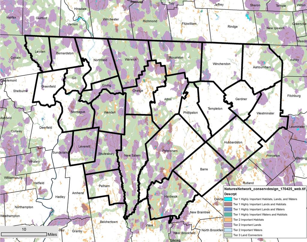
51 Examples of the Data within RCP regions Brian Hall
52 Webmap link:

53

54

55

56

57

58

59

60
61
62

63

64

65
66

67

68

69

70
71 Webmap link: DataBasin: badc710319/active DataBasin (more details) 4acc930a055#expand= For more information: Schwenk, William