VT AOT Chittenden County Circumferential Highway Essex Junction
|
|
|
- Gervais Matthews
- 5 years ago
- Views:
Transcription
1 VT AOT Chittenden County Circumferential Highway Essex Junction File No.: City and State: Essex Junction, VT General Impacts: 20.2 acres other 3.4 acres PEM meadow and marsh 13 acres PEM hayfield 2.6 acres PFO 1.2 acres PSS Functions and Values Lost: Groundwater Floodflow Alteration Sediment Retention Nutrient Retention Shore Stabilization Wildlife Habitat Year(s) Mitigation Constructed: October 1992 Size and Type of Mitigation as Proposed: Mitigation site plus 30 acres upland preservation Proposed Functions and Values of Mitigation: Floodflow Alteration Nutrient Removal Wildlife Habitat Mitigation Special Condition(s): 5. The mitigation site depicted on the plans titled Vermont Route 289 Williston Colchester PB033-1(1) in 7 sheets numbered 101 through 107 and Boundary Survey revised 20 July 1989 and the plot survey of a 30 acre upland buffer area/travel corridor shall be subject to a conservation easement. Such conservation easement shall ensure that the mitigation sites are preserved in perpetuity. Acquisition of the mitigation sites are granting of the conservation easement shall be completed prior to any fill being discharged into wetlands or waters of the project site. Documentary evidence sufficient to establish the completed acquisition of the mitigation site and granting of the conservation easement shall be furnished to the Corps prior to any fill being discharged
2 into wetlands or waters on the Segment II project site. The state (including the VT AOT or VT Agency of Natural Resources) or federal agency or a non-profit conservation organization. Remarks: None Directions: Take 128/95 north to Route 3 north. Take exit 32B/32A towards Lowell/Nashua, NH staying on Route 3 north. Stay straight to go onto Frederick E. Everett Turnpike. It becomes I-93 north. Take I-89 north towards Lebanon/White River Junction, VT. Keep right merging onto I-89 north. Take exit 15, VT-15 towards Winooski/Essex Junction. Keep left at the fork in the ramp. Turn right onto VT-15 east. Turn left onto Susie Wilson Road. It becomes Susie Wilson Bypass. Turn left onto VT-2A.
3 Street Atlas USA DeLorme. Street Atlas USA MN (15.5 W) TN Scale 1 : 8, ft m 1" = 711 ft


4 VT AOT, CCCH Segment 2 Copyright (C) 1997, Maptech, Inc.
5 MITIGATION SITE FIELD DATA FORM Site Name: VT AOT CCCH - Essex Junction File No City/Town: Essex Junction State: VT Waterbody: Monitor(s): Paul Minkin, Keith Wright Date: Was site constructed? yes Is site wetland? yes Size of proposed wetland: TBD Actual size of wetland: TBD Lat/Long Points: N W Saved GPS Waypoint name: EJ90 GPS Tracking Log Name: N/A Perimeter: TBD Surrounding land use: Railroad, highway, upland forest Is wetland function compromised by surrounding land use? Stormwater may bring pollutants into wetland. The transportation corridors diminish wildlife habitat. Plant health: Vigorous Invasive species: Phalaris arundinacea Wildlife use: Beaver lodge, green frogs, deer tracks Plants: Asclepias incarnata Asteraceae sp. Carex lurida Carex sp. Carex sp. (ovales) Carex vulpinoidea Cyperus strigosus Eupatorium fistulosum Euthamia graminifolia Galium sp. Glyceria sp. Ilex verticillata Impatiens capensis Ipomoea sp. Juncus effusus Leersia oryzoides Lemnaceae sp. Lycopus sp. Onoclea sensibilis Phalaris arundinacea Polygonum sagittatum Potamogeton sp. Rubus sp. Sagittaria latifolia Scirpus cyperinus Scirpus microcarpus Scirpus validus Soldiago sp. Spaganium sp. Spiraea latifolia Trifolium repens Typha latifolia Verbena hastata Vicia sp. Page 1 of 2
6 Soils Data: Soil examination revealed low chroma colors (10YR3/1) down to a foot in depth with redox features (10YR 6/6) found at 3 inches. Sketch approximate mitigation site, noting areas and types of wetlands, waters, other features, landscape position, landmarks, etc., and data and photo point(s) See file. Overall Description of site: The site was quite wet even in drought. It consists of a large basin that is surrounded by a wetland fringe. An overwhelmingly strong sulfidic odor emanates from footsteps made along the shoreline. Vegetation is quite thick. A gate behind the gas company was used to access the site, which is surrounded by a fence. Comments, problems, recommendations: None Page 2 of 2
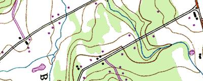
7
8 9.18 ac yes yes no upland forest, railroad 20 feet , VTAOT CCCH Essex Junction/Segment N W PM PEM, POW 60% yes 0 X X unknown X 3,6,8,9 dense vegetation surrounding open water X shallow open water may support some warm water fish X 1,2,3,9 X downslope of railroad and highway X 2,3,4,5,8,9,10 X dense vegetation surrounding open water X 2,4,7 wildlife food, extremely limited X 3,7,12 dense vegetation surrounding open water X 3,5,7,8,11,12,13,17,19 beaver lodge, green frogs, deer tracks, birds X access to site difficult X X X X none known at site

9 VTAOT CCCH Essex Junction Essex Junction, VT 8/19/02 Photo looking southwest from beyond northeast corner of site


10 8 km NE of Burlington, Vermont, United States 25 Apr 1999 Image courtesy of the U.S. Geological Survey 2003 Microsoft Corporation. All rights reserved.