Waituna Creek Restoration
|
|
|
- Brian Mason
- 5 years ago
- Views:
Transcription


1


2 Waituna Creek Restoration Beech Jane Bowen, Mary

3 HISTORY OF THE WAITUNA CATCHMENT Loss of large areas of swamp, bog and fen Resulting in Degraded habitat and fauna Highly modified channel and hydrology Lowland river in intensively farmed catchment

")
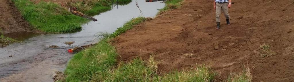
")
4 PROGRESSING TOWARDS CHANGE What we had (past ) What we got ( present) The aim (2018 -????)


5 WHY CHANGE? Cultural significance to Ngāi Tahu Statutory Acknowledgement Internationally significant wetland - Ramsar convention Large proportion of available fish habitat Diverse fish population Tuna Threatened Longfin eel At risk Giant kokopu At risk Inanga-At risk DOC marginal strip and esplanade reserve

6 THE AIM Waituna Scenic Reserve Seaward Moss QEII covenant Marginal Strip Continuous river corridor from the Lagoon upstream Reconnect remaining native vegetation Provide continuous access along the Creek Improve bank stability and habitat Improve instream habitat Esplanade Reserve Scientific Reserve/lagoon


7 DESIGN AND PREPARATION

8 Don t DESIGN CONSIDERATIONS reduce drainage capacity reduce flood capacity affect access and visibility for diggers on at least one bank increase erosion Do s at low to medium flow increase stable habitat increase depth and flow diversity increase sinuosity increase overhanging vegetation and margin all work within marginal strip boundary

9 Initial design W 7 2 m 7 7 m 6 9 m 5 m m 10 m 3 31 m Chainage Height True Left Cross section W6 True Right W 6 W25a W3f
10 ALTERATIONS TO PLANNING Alternative log vane arrangement One sided arrangement to preserve existing habitat Hydrology report shows two sided arrangement better for habitat and lower risk of erosion Engineering concerns and solutions Finding a solution which was secure yet not over engineered


11 CONSULTATION Environment Southland catchment division Awarua runaka- joint resource consent holder Resource consent applications Affected parties Landowner support for project Marginal strip/land tenure ongoing


12 CONSTRUCTION EARTHWORKS
13 CONSTRUCTION LOG VANES

14 CONSTRUCTION LOG VANES
15 Manuka sourced from track cutting CONSTRUCTION MANUKA BUNDLES Installed individually and also in V formation Wired together and anchored using warratahs

16 CONSTRUCTION PLANTING Coir matting for sediment control Contracted forestry crew


17
18 CONSULTATION MONITORING This year carried out during construction Reduced fish numbersdrought, temporary disturbance? Fish already utilizing structures.

19 WHAT DIDN T GO TO PLAN? Minor top soil loss -increased pinning of matting -reporting to regional council Loss of one log vane


20 THE END RESULT One in two year flood and no major issues Increased complexity of creek, aesthetics, addition of riffle, pool habitat Need further fish monitoring before we can determine if providing this habitat has a corresponding increase in fish biomass/abundance Largely positive feedback from the community, affected parties and stakeholders
21 WHAT S NEXT? Whakamana te Waituna A trust made up of DOC, Regional Council, District Council, Ngai Tahu, Awarua Runaka, Living Water and Fonterra Waituna Transformation Project is one of five work streams under Whakamana te Waituna
22 WHAT S NEXT? June Waituna Creek Workshop Creek walk to identify options for the next five years 20 individual projects identified at specific locations and scoping report prepared Cultural Biodiversity/Ecological Recreational


23 THANK YOU


24
25

 to both banks from the height of a normal fresh. We have used this as the base line to work from i.e. we have applied the Queen s chain to the channel alignment in 1951 to establish where the marginal strip should be.")
26 Marginal strip origin Based on Campbelltown hundred map from 1913 (see next slide maybe delete) only a sketch and never fully surveyed. Alignment compared with the 1951 aerial photos and plotting the creek line, opposite, shows: Survey sketch doesn t align well at all. Most likely due to accuracy of the original sketch. No survey notes explaining rational for shape. Norm at the time was to apply a Queen s chain (20.1 m) to both banks from the height of a normal fresh. We have used this as the base line to work from i.e. we have applied the Queen s chain to the channel alignment in 1951 to establish where the marginal strip should be.
.")
27 Campbelltown Hundred 1913 Red box is area of Marshall Road Farm (that part of the farm relevant to the marginal strip).
28