Public Notice ISSUED: EXPIRES:
|
|
|
- Matilda Powers
- 5 years ago
- Views:
Transcription
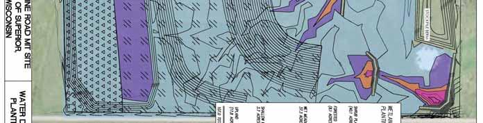
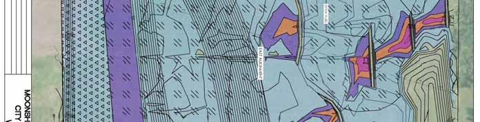
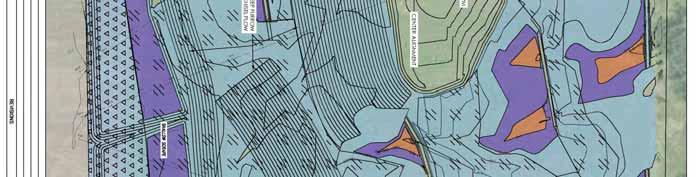
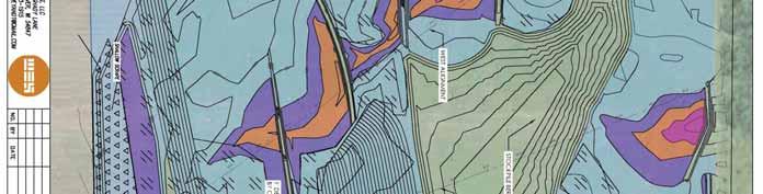
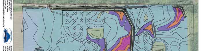
1 SPONSOR: City of Superior Public Notice ISSUED: EXPIRES: REFER TO: WMS SECTION:404 - Clean Water Act 1. WETLAND COMPENSATORY MITIGATION BANK PROPOSAL 2. SPECIFIC INFORMATION. SPONSOR S ADDRESS: City of Superior 1316 North 14 th Street #200 Superior, Wisconsin PROJECT LOCATION: The project site is located in the east ½ of Section 23, T. 48N., R. 12W., Douglas County, Wisconsin. Latitude , Longitude BANK SERVICE AREA: The proposed primary bank service area is the city of Superior. The secondary bank service area is the Lake Superior watershed within Douglas County, Wisconsin. DESCRIPTION OF PROJECT: The sponsor is proposing to develop the Moonshine Road Wetland Bank. The proposed bank site is approximately 107 acres in size. CURRENT LAND USE, INCLUDING ADJACENT PROPERTIES - The site is currently a hay field. It has been a productive hay field for at least 60 years. It is relatively flat and slopes down toward the north, losing a total of 15 feet in elevation from the highest to lowest point. Natural drainage patterns have been straightened and enlarged to enhance drainage for hay production. Drainage ditches converge into two main channels that drain to the center of the northern boundary and into the northwest corner. The Douglas County soil survey data indicates the vast majority of the site consists of Amnicon-Cuttre complex, which is rated as predominantly non-hydric. However, Bergland components are considered hydric, making up 3% of the map unit and located in depressions and drainage ways. Approximately 7.86 acres of existing wetlands were delineated on the property. Vegetation in the upland areas is typical of hay fields, dominated by cool season forage grasses with a mix of native grasses, sedges and forbs. Vegetation in the wetlands is comprised of native sedges, rushes and forbs. MODIFICATIONS PROPOSED TO RESTORE, ESTABLISH, ENHANCE AND/OR PRESERVE WETLANDS ON THE BANK SITE Activities proposed on the site involve a combination of design features to capture hydrology as the site drops in elevation by approximately 15 feet from the highest to lowest point. These features include the construction of shallow ditch plugs, two shallow scrapes and creation of microtopography to restore approximately 80 acres of wetlands. The construction of shallow ditch plugs in main ditch lines would allow surface saturation and/or shallow water to extend laterally while minimizing soil disturbance. Two large shallow scrapes separated by a berm is proposed to be constructed along the south side (highest point) of the property. The two
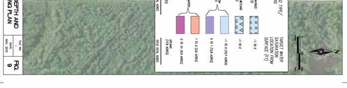
2 Operations - Regulatory ( WMS) scrapes would occupy approximately 12 acres of the site and be planted with wetland tree species on the southern half and shrubs on the northern half. Clay from the scrapes would be used to construct the ditch plugs. Microtopography would be created on portions of the site which would be chiselplowed to create shallow 6-12 inch furrows to retain water. Approximately half the site would be planted to trees and/or shrubs. This includes not only forested and shrub wetlands, but forested uplands as well. The remainder of the site is intended to be open habitat comprising wet/sedge meadows and shallow marsh. Proposed target habitat types are based on the type and quantity of credits that have been sold within the last 5 years at the City of Superior SAMP mitigation bank. Final credits and credit ratios by habitat type will be determined by the Interagency Review Team (IRT). Proposed target habitat types with acreage totals and percentages are shown below on Table 1. Table 1. Proposed habitat types, with acreage totals and percentages. Habitat Type Plan Sheet (method of generating credits) Designatio Acres % Shallow Marsh (restored) Shallow Marsh % Sedge Meadow (2.5 acres preserved) Fresh Wet Meadow (4.7 acres preserved) Sedge / Wet Meadow (30.1 acres restored) Shrub Carr (restored) Wet Meadow Shrub Plantings % 37.5% Forested Wetland (restored) Forested Wetland % Upland (enhanced) Upland % TOTAL % LONG-TERM MANAGEMENT OF THE SITE: The City of Superior currently owns the property and will continue to maintain ownership long term. Similar to other wetland mitigation sites owned by the City, a permanent conservation easement will be placed on the site with covenants to ensure it will be protected in perpetuity. SURROUNDING LAND USE: The site is bordered to the north, east and west by forestland. An active hay field, horse pasture and private residence are located on the adjacent parcel to the south. COORDINATION WITH RESOURCE AGENCIES: This project has been coordinated with the following members of the Interagency Review Team (IRT) and other resource agencies: Wisconsin Department of Natural Resources, U.S. Environmental Protection Agency, U.S. Fish and Wildlife Service, and U.S. Department of Agriculture. 3. REPLIES/COMMENTS. Interested parties are invited to submit to this office written facts, arguments, or objections within 30 days of the date of this notice. These statements should bear upon the suitability of the location and the adequacy of the project and should, if appropriate, suggest any changes believed to be desirable. Comments received may be forwarded to the applicant. A copy of the full prospectus submitted by the Sponsor is available to the public for review upon request. 2
3 Operations - Regulatory ( WMS) Replies may be addressed to Regulatory Branch, St. Paul District, Corps of Engineers, Hayward Field Office, Rivers Edge Drive, Suite 240, Hayward, WI Or, IF YOU HAVE QUESTIONS ABOUT THE PROJECT, call Bill Sande at the Hayward office of the Corps, telephone number (715) To receive Public Notices by , go to: and add your information in the New Registration Box. 4. FEDERALLY-LISTED THREATENED OR ENDANGERED WILDLIFE OR PLANTS OR THEIR CRITICAL HABITAT. None were identified by the applicant or are known to exist in the permit area. However, Douglas County is within the known or historic range of the following Federally-listed threatened (T) or endangered (E) species: Species Grey Wolf (E) Northern Long-Eared Bat (T) Rufra Red Knot (T) Canada Lynx (T) Habitat Northern forested areas. Hibernates in caves and mines swarming in surrounding wooded areas in autumn. Roosts and forages in upland forests during spring and summer. Along Lake Superior While no resident populations are known from Wisconsin, the species occasionally occurs in northern forested areas, and counties listed are those with the highest likelihood of occurrence. Kirtland s Warbler (E) Potential breeding in young jack pine stands (5 to 25 years old). Piping Plover (E) Fassett s Locoweed (T) Sandy beaches; bare alluvial and dredge spoil islands. Open sandy lakeshores. This notice is being coordinated with the U.S. Fish and Wildlife Service. Any comments it may have concerning Federally-listed threatened or endangered wildlife or plants or their critical habitat will be considered in our final assessment of the described work. 3
4 Operations - Regulatory ( WMS) 5. JURISDICTION. The aquatic resources, if any, within the boundaries of the proposed mitigation bank are being reviewed in accordance with current practices for documenting Corps jurisdiction under Section(s) 9 & 10 of the Rivers and Harbor Act of 1899 and Section 404 of the Clean Water Act. We have made a preliminary determination that the aquatic resources within the boundaries of the proposed mitigation bank are subject to Corps of Engineers jurisdiction under Section(s) 9 & 10 of the Rivers and Harbors Act of 1899 and/or Section 404 of the Clean Water Act. If an approved jurisdictional determination is completed for this mitigation bank, a copy will be posted on the St. Paul District web page at the following link: Any regulated discharges associated with implementation of a final approved bank plan could likely be authorized by regional general permit if the bank plan is approved before any regulated discharge occurs. Any required compensatory mitigation would be accounted for in the credit yield calculations because this is a mitigation bank project. 6. HISTORICAL/ARCHAEOLOGICAL. The Corps will review information on known cultural resources and/or historic properties within and adjacent to the project area. The Corps will also consider the potential effects of the project on any properties that have yet to be identified. The results of this review and the Corps determination of effect will be coordinated with the State Historic Preservation Officer independent of this public notice. Any adverse effects on historic properties will be resolved prior to the Corps authorization, or approval, of the work in connection with this project. 7. PUBLIC HEARING REQUESTS. Any person may request, in writing, within the comment period specified in this notice, that a public hearing be held to consider this application. Requests for public hearings shall state, in detail, the reasons for holding a public hearing. A request may be denied if substantive reasons for holding a hearing are not provided or if there is otherwise no valid interest to be served. Enclosure(s) Tamara E. Cameron, Chief, Regulatory Branch 4

5 22 Rd Anderson Rd Wentworth Rd Erickson Rd Potter Rd Erickson Rd Tallberg Rd DOUGLAS COUNTY, WI Kaelin Rd Moonshine Rd SUPERIOR City of Superior PARKLAND Ê LAKESIDE AMNICON CLOVERLAND MAPLE BRULE Partridge Ln SUMMIT OAKLAND HAWTHORNE BENNETT HIGHLAND Wentworth Rd Cnty Road D DAIRYLAND SOLON SPRINGS GORDON US Hwy 2 Golf Course Rd WASCOTT Figure 1. Mitigation Site Location Prospectus: Moonshine Road Mitigation Site 2013 Aerial Photo. Map by D. McNamara, City of Superior, September Miles

6 Primary Bank Service Area: City of Superior, preference for SAMP Projects City of Superior Hwy13 Ê Proposed Mitigation Site Hwy 2 Hwy 35 Lake Superior Basin Secondary Bank Service Area: Lake Superior Basin within Douglas County Douglas County Hwy 53 Miles Figure 2. Proposed Bank Service Area Prospectus: Moonshine Road Mitigation Site Map by D. McNamara, City of Superior, September Bank Service Areas (BSA's) and Water Basins of Wiscosin. Guidelines for Wetland Compensatory Mitigation in Wisconsoin, Version 1. US Army Corps of Engineers, August 1, 2013.


7 8.4 1BHF PG
8