Land Sales Specialists Setting the trend for how Real Estate is sold in the Midwest.
|
|
|
- Isaac Bryant
- 5 years ago
- Views:
Transcription
 442-3177 1711 Oregon Hiawatha, KS 66434 (785) 742-4580 1708 Prairie View Rd, Suite B Platte City, MO 64079 (816) 219-3010 This property could be purchased")


 851-1125 or jamie@barnesrealty.")
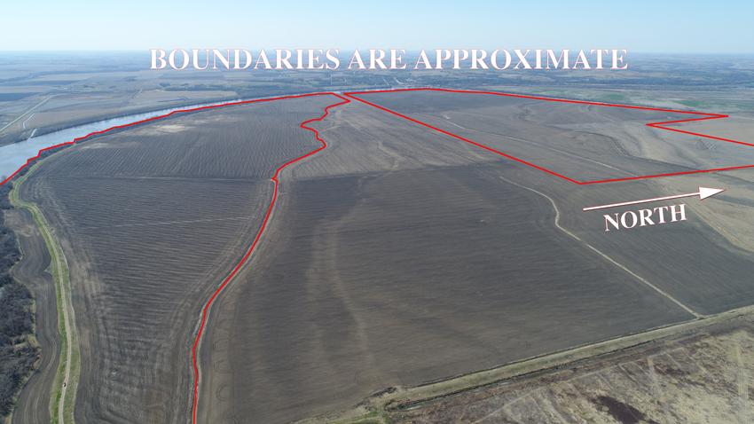
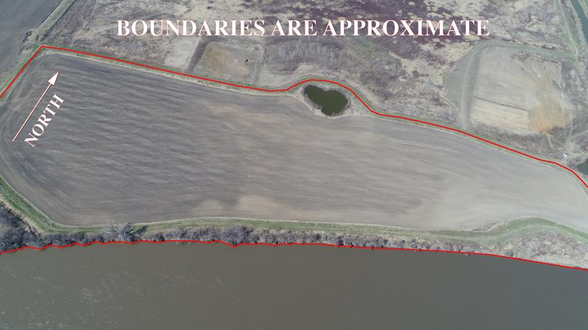
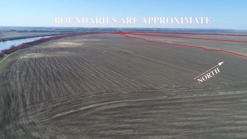
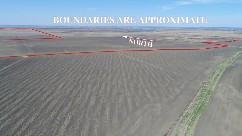
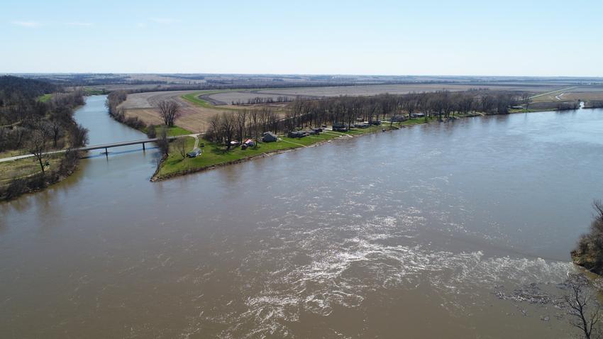
1 Land Sales Specialists Setting the trend for how Real Estate is sold in the Midwest Hwy 59 Mound City, MO (660) Oregon Hiawatha, KS (785) Prairie View Rd, Suite B Platte City, MO (816) This property could be purchased in thirds and be kept together! Unlimited water for irrigation, good soils, and blacktop access with almost 2,000 acres in one piece with good levee protection. Don t you just love the opportunity in this country!? LOCATION: Property is located just East of Rulo, NE and runs along Hwy 159 and the Missouri River. PRICE: $8,750.00/taxable acre or $17,115, total. Buy 1/3 of this now, on the premise the whole tract stays together, and pay a Per Diem amount and close on the rest as you so choose. Talk to the Listing Agent for details! FSA INFORMATION: See Attached IMPROVEMENTS: 250,000 bushels of storage Grain leg unloading pit 120 X 70 Shop w/ concrete 115 X 46 Machine shed TAXES/TAXABLE ACRES: 2017 taxes were $6, on 1, taxable acres. RENTAL STATUS: This tract has had one cash rent tenant in place now going on 10 years. Annual market rent adjustments occur as needed since lease is year to year. If you re an investor purchaser, contact listing agent for latest market rent arrangement. LISTING AGENT: Jamie Barnes (660) or jamie@barnesrealty.com BROKER PARTICIPATION: Barnes Realty Company, as listing Broker, will gladly and fully cooperate with most licensed Real Estate Brokers to obtain a sale of the property on terms satisfactory to the current Owners. Brokers should call our office for details of our Co-Brokerage Policy. Setting the trend for how Real Estate is sold in the Midwest. This information is thought to be accurate; however, it is subject to verification and no liability for error and omissions is assumed. Barnes Realty has made every effort to present accurate information on the property presented. Most of the information comes from outside sources: County/Government/Seller and human error can occur. It s the Buyer s responsibility to satisfy himself with the information presented and to determine the information to be true and accurate and the property to be suited for his intended use. The listing may be withdrawn with or without approval. The Seller further reserves the right to reject any and all offers. All inquiries, inspections, appointments, and offers must be sent through: RICK BARNES, BROKER, BARNES REALTY COMPANY, HWY 59, MOUND CITY, MO PHONE NUMBER:


2 Google Aerial Map General Location Map


3 Driving Map Tax Map Irrigation Location Maps


4 Tract 1 Tract 2

5 Surety Map Aerial Map map center: 40 2' 48.41, ' ft 3612ft 7224ft Holt County Missouri 8/23/2018
")

6 Soil Map Total Tract Soils Map State: Missouri County: Holt Location: 40 2' 48.41, ' 47.2 Township: Minton Acres: 1956 Date: 8/23/2018 Soils data provided by USDA and NRCS. Area Symbol: MO087, MO087, Soil Soil Area Area Version: Version: Code Soil Description Acres Percent of field Non Irr Class Legend Non Irr Class *c Irr Class *c Range Production (lbs/acre/yr) NCCPI Overall NCCPI Corn NCCPI Small Grains NCCPI Soybeans NCCPI Cotton Grable Leta complex, 0 to 2 percent slopes, rarely flooded Leta silty clay, 0 to 2 percent slopes, rarely flooded Luton clay, 0 to 2 percent slopes, rarely flooded Sarpy loamy fine sand, 0 to 2 percent slopes, rarely flooded Haynie silt loam, deep loess, 0 to 2 percent slopes, rarely flooded % IIIs % IIw % IVw % IVs % Is Is Water % VIII Weighted Average *c: Using Capabilities Class Dominant Condition Aggregation Method Soils data provided by USDA and NRCS.
")

7 Soil Map Tillable Soils Map State: Missouri County: Holt Location: 40 2' 48.41, ' 47.2 Township: Minton Acres: Date: 8/23/2018 Soils data provided by USDA and NRCS. Area Symbol: MO087, MO087, Soil Soil Area Area Version: Version: Code Soil Description Acres Percent of field Non Irr Class Legend Non Irr Class *c Irr Class *c Range Production (lbs/acre/yr) NCCPI Overall NCCPI Corn NCCPI Small Grains NCCPI Soybeans NCCPI Cotton Grable Leta complex, 0 to 2 percent slopes, rarely flooded Leta silty clay, 0 to 2 percent slopes, rarely flooded Sarpy loamy fine sand, 0 to 2 percent slopes, rarely flooded Luton clay, 0 to 2 percent slopes, rarely flooded Haynie silt loam, deep loess, 0 to 2 percent slopes, rarely flooded Leta silty clay, 0 to 2 percent slopes, frequently flooded % IIIs % IIw % IVs % IVw % Is Is % IIIw Water % VIII Weighted Average *c: Using Capabilities Class Dominant Condition Aggregation Method Soils data provided by USDA and NRCS.

8 FSA Aerial Map Farm 3627

9 FSA Aerial Map Farm 3628
10 FSA 156EZ Farm 3627
11 FSA 156EZ Farm 3628

12 FSA 578 Farm 3627
13 FSA 578 Farm 3628

14 Aerial Photos
15


16


17

18
19


20