Improvements in Landsat Pathfinder Methods for Monitoring Tropical Deforestation and Their Extension to Extra-tropical Areas
|
|
|
- Phoebe Gibbs
- 5 years ago
- Views:
Transcription
1 Improvements in Landsat Pathfinder Methods for Monitoring Tropical Deforestation and Their Extension to Extra-tropical Areas PI: John R. G. Townshend Department of Geography (and Institute for Advanced Computing Studies) University of Maryland
2 Objectives Objectives To assess whether the overall approach successfully used in Landsat Pathfinder for the humid tropics can also be used in other regions to satisfy the needs of the Global Observations of Forest Cover To carry out large scale prototyping of several advanced processing procedures, including pre-processing to reduce atmospheric and MTF effects, multi-temporal unsupervised processing, application of decision-tree methodologies, mixture modeling and other advanced procedures developed under previous research.
3 Objectives Objectives To assess the improvements introduced by advanced processing procedures using data from areas in the Pan- Amazon and Central Africa that were part of the previous Landsat Pathfinder work. Investigate how the original Landsat Pathfinder methodology and the enhancements proposed operate in selected areas throughout the globe. Paraguay, southern Africa, central Asia, Eastern United States, selected sites in the boreal forest.
4 Science Implications Science Implications The Landsat Pathfinder project has demonstrated the feasibility of monitoring forest cover change over very large areas using Landsat data. To extend this approach to satisfy the needs of the Global Observations of Forest Cover will require an assessment that the overall approach successfully used in Landsat Pathfinder for the humid tropics can also be used in other regions and that more automated procedures are used.
5 NASA Landsat Pathfinder Humid Tropical Deforestation Project A collaborative effort between the University of Maryland at College Park s Geography Department, Michigan State University and NASA Goddard Space Flight Center s GIMMS Group. The goal of this work is to map global deforestation for the humid tropics. Heritage Data sets from both the TM and MSS of Landsat have been used for three time periods, the 1970s, 1980s, and 1990s. The project has focused on - the Amazon Basin, Central Africa, and Southeast Asia, which are the three regions where most of the tropical deforestation in the world has occurred. The Pathfinder project includes about 75% of the tropical rain forest areas. The University of Maryland has had responsibility for the non-brazilian Amazon Basin (also known as the Pan-Amazon) along with central Africa (Details can be found at and Michigan State University has responsibility for the Brazilian Amazon Basin and Southeast Asia.
6 Heritage Landsat Pathfinder Procedures for Classification Utilize existing automated methods Utilize the skills of the human interpreter to refine the classification Multispectral/ Multitemporal approach
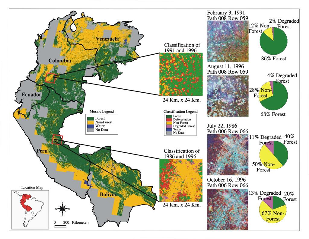
7 Landsat Pathfinder Procedures for Classification Heritage Landsat Pathfinder produces simple but accurate maps of the humid tropical forest - nonforest boundary based on Thematic Mapper (TM) data from the Landsat satellites. This information can be used to detect changes in forest cover, for modeling global climate change or for other research purposes. Pathfinder uses isodata clustering image processing algorithms to produce thematic maps from Landsat imagery. Spectral data from two coregistered scenes are processed simultaneously so that areas of change can be readily identified. The example presented here uses a small portion of Landsat scenes of the northwest Democratic Republic of Congo from 1987 and km 0 5 km February 1987 Path 179 Row 058 An 800 x 800 pixel subset of Landsat 5 TM bands 4,5,3 (R,G,B) December 1994 Path 179 Row 058 An 800 x 800 pixel subset of Landsat 5 TM bands 4,5,3 (R,G,B)
8 Landsat Pathfinder Procedures for Classification Heritage Masks of cloud, shadow, water and land cover are created from the data. Data under cloud, shadow or water masks are not processed further. An unsupervised classification process is applied to data under the land cover masks. Iterative isodata clustering produces large numbers of clusters or groups of pixels based on the spectral data from both images. Forest Nonforest Degraded forest Water Forest to Nonforest (Deforestation) Forest to Degraded Forest (Degradation) Nonforest to Degraded Forest (Regrowth) Degraded forest to Nonforest 0 5 km Composite Map Each cluster is assigned a color which represents a particular land cover type or land cover change between the two images, e.g., forest to nonforest (deforestation), nonforest to forest (regrowth), etc. A modeling program classifies each pixel based on the color assigned to its cluster. The result is a composite map of land cover which includes change between the two scenes.
9 Landsat Pathfinder Procedures for Classification Heritage The composite map may require editing to reclassify those pixels which are spectrally very similar but represent different cover types. In the example shown here, the plantation areas which appeared as forest are reclassified as nonforest according to the project definitions of cover type. Forest Nonforest Degraded Forest Water Forest to Nonforest (Deforestation) Forest to Degraded Forest (Degradation) Nonforest to Degraded Forest (Regrowth) Degraded forest to Nonforest 0 5 km Edited Change Map
10 Landsat Pathfinder Procedures for Classification Heritage The edited composite change map is split and filtered into thematic maps for each scene. The thematic maps are georegistered and mosaicked into a country wide product for a specific time period. Forest Nonforest Degraded Forest Water 0 5 km Thematic Map 1987 Thematic Map 1994

11 Landsat Pathfinder Procedures for Classification Spectral bands time 1 Spectral bands time 2 Composite map Edited composite map Heritage Thematic map time 1 Thematic map time 2
12 Heritage Landsat Pathfinder Procedures for Classification The current system is producing a very consistent and accurate product as is indicated by the fact that little, or no thematic corrections are ever necessary when adjacent classified scenes are joined together. Mechanisms are in place where, as further auxiliary information is made available, the classification can be improved.
13 Heritage Results from Landsat Pathfinder Results from Landsat Pathfinder project have produced delimitations of tropical deforestation in the Pan-Amazon with unprecedented accuracy for most areas. Figure 1 shows in summary the distribution of the main hot spots in the Pan-Amazon, but this gives only a very superficial impression of the detailed data base that has been created.

14 Pan-Am Hotspots

15 Heritage Results from Landsat Pathfinder Large parts of the Pan-Amazon are being deforested. We have documented a spatially-concentrated "deforestation zone in Santa Cruz where >60% of the Bolivian deforestation is occurring at an accelerating rate in areas of tropical deciduous forest
16 Heritage Results from Landsat Pathfinder Results of large area classifications are significantly changing views of the rates of tropical deforestation. For example in Bolivia the total closed canopy forest cover extent, including tropical deciduous forest, totaled 472,000 km 2. The area deforested totaled 15,000 km 2 in the middle 1980s and 28,800 km 2 by the early 1990s. The rate of tropical deforestation in forest zone of Bolivia with >1,000 mm y -1 precipitation was 2,200 km 2 y -1 from to Our estimates of deforestation are significantly lower than those reported by the FAO, but are higher than in-country estimates since the mid-1980s (Steininger et al. 1999).
17 Table 1. Summary of deforestation estimated for Bolivian forests, based on digital analysis of Landsat Thematic Mapper (TM) and Multispectral Scanning System (MSS) images. All areas are in km2 and rates are in km2 y-1. Data from the 1980s are from 1984 to 1987, the 1990s are from All forest in the >1000 mm precipitation zone were mapped (Steininger et al. 1999). Department Potential Forest Forest Non- Forest Deforested by the 1980s* Deforested By the 1990s Deforestation 1980s 1990s Water Cloud Nodata Total Area Ben 92,277 87, , ,909 2,093 9,564 3,030 2, ,560 Cochabamba 26,390 20,322 27,834 1,520 2,774 1, ,346 2,964 57,732 La Paz 64,351 56,318 37,422 1,238 2,869 1, ,781 24, ,626 Pando 58,789 55,999 1, , ,264 2,103 63,405 Santa Cruz 218, , ,179 10,835 18,616 7,782 2,051 1,390 20, ,160 Chuquisaca 11,039 10,842 24, ,982 50,884 Sum 471, , ,615 15,073 28,801 13,724 13,791 15,961 67, ,367 *Areas deforested by the middle 1980s were only mapped below 1000 m elevation; 1,645 km2 of the total deforestation between the time periods were in areas over 1000 m above sea level.
18 Heritage Results from Landsat Pathfinder In Africa rates of deforestation are much less than the Amazon Few very large areas of clearance observed Land cover changes that occur are often associated with previously cleared degraded forests, which have regrown
19 Results from Landsat Pathfinder Heritage
20 Methods Methods Preprocessing of Landsat data Mixture Modeling Improved Landsat Pathfinder Procedures Supervised Approaches Application of Coarse Resolution Data Products
21 Methods Preprocessing of Landsat TM data Automated co-registration Previously tested algorithms (Fonseca and Manjunath 1996). Atmospheric correction. Dark target approach (Kaufman et al. 1988). Algorithm has been successfully implemented on our SP-2 high performance computer
22 Methods Preprocessing of Landsat TM data MTF Effects Assess the optimal pixel size Explore the development of a non-linear filter Assess the implications of enhancing noise due to this procedure Assess the extent to which these problems impact Thematic Mapper data
23 MTF table Table 2 Standard Errors of the Estimate (SEE) * of MODIS Simulated Data for 250m Pixels (at the 90% Confidence Limit) for the Reflective Bands, Namely Bands 1 to 5 and 7 (B1 B5 and B7) of the Thematic Mapper for Partially Forested Test Site in Central Maryland. The Final Column Shows the SEE for the Estimated Vs. The Actual Percentages of Land Cover. The Results Indicate the Major Impacts of the MTF of the Sensor and Reductions in Their Impacts by Pixel Enlargement and deconvolution (Townshend Et Al. 1999). Pixel size (m) and procedure for generating images B1 (DN) B2 (DN) B3 (DN) B4 (DN) B5 (DN) B7 (DN) Land Cover % Error m, derived by simple averaging m, MTF simulation m, aggregated from m, MTF deconvolved m, aggregated from
24 Methods Mixture Modeling Intend to apply mixture modeling to assist in classifying areas of partial tree cover. Two approaches will be tested. Characterize each scene as a mixture of basic components to assist in the labeling of the clusters in the unsupervised classification Derive proportions of scene components and then derive differences in proportions between adjacent time periods
25 Methods Improved Landsat Pathfinder Procedures The most time-consuming part of the work for the human analyst is the assigning the hundreds of spectral clusters labels of the land cover classes. Instead we will implement a hybrid unsupervised and supervised classification.
26 Methods Improved Landsat Pathfinder Procedures This approach will rely on an unsupervised statistics based clustering algorithm to iteratively create several hundred cluster classes. Clusters will then be automatically assigned to output classes based on training bitmaps created by the human analyst.
27 Methods Improved Landsat Pathfinder Procedures Where a cluster is included in more than one of the land cover classes, bit maps will automatically be created over all pixels belonging to those classes throughout the scene Subsequent unsupervised classification will then be carried out until all clusters are only associated with a single land cover class. Analyst input will still be needed but this procedure has been shown to reduce their level of effort by a factor between approximately 2 and 3 dependent on the scene being analyzed.
28 Methods Improved Landsat Pathfinder Procedures Analyst first identifies polygon bitmaps on image which are assigned to a vegetation or change class. Forest Deforestation Non-Forest
29 Methods Improved Landsat Pathfinder Procedures Unsupervised clustering algorithm is run independently of the training sites. Clustering output Forest Non-Forest Deforestation We have developed a program to compare the training site bitmaps and the output clusters from the unsupervised classification.
30 Methods Improved Landsat Pathfinder Procedures Clustering output Thematic Map Automatic Modeling Those clusters belonging solely to a single land cover class will be automatically labeled and will not need to be examined further by the analyst. Where a cluster is derived which includes more than one of the land cover classes, then bit maps will automatically be created over all pixels belonging to those classes throughout the scene and subsequent unsupervised classification will then be carried out until all clusters are only associated with a single land cover class.
31
32 Methods Supervised Approaches Increasingly improvements in our understanding of spectral classes and ground conditions means that a more directed supervised approach becomes feasible in many areas. We will evaluate the following approaches. Neural nets Multi-layer perceptron (MLP) - Three layer network structure (input, hidden and output) Decision Tree Classifiers
33 Application of Coarse Resolution Data Products We will examine the extent to which we can use multi-temporal sequences of MODIS data, especially the NDVI and its improved vegetation indices to assist the characterization of forest types especially in relation to leaf type and duration.
34 Extension to Other Regions Sub-tropical forests in South America including the Chacoan Forests Woodlands and wooded grasslands of Eastern Africa including woodland types such as miombo and mopane woodlands Deciduous and mixed temperate forests in Maryland. Boreal forests from central Asia in Mongolia, Russia and Alaska.
35 Assessment of Procedures Assessment of Procedures Two main approaches will be adopted in assessing the performance of the various procedures Carefully characterized ground sites based on field work Previously well characterized complete scenes based on field work and previous Landsat Pathfinder classification
36 Ground sites based on field work by collaborators Assessment of Procedures These sites will be used primarily to assess the accuracy of the procedures that are developed Southern Santa Cruz, Bolivia - Dr. Tim Killeen Noel Kempf National Park, Bolivia - Dr. Tim Killeen Venezuela - Dr. Otto Huber of the University Simon Bolivar, Caracas Manaus, Brazil - Dr. Marc Steininger Southern Africa Woodlands MODIS validation team Boreal Forests - Dr. Eric Kasischke of ERIM, Dr Clyde Goulden of the Institute of Mongolian Biodiversity & Ecological Studies 3 sites in Maryland MODIS
37 Assessment of Procedures Previous Landsat Pathfinder Classifications Sites in the tropics will be used primarily to assess the extent to which Landsat Pathfinder results involving intensive human intervention can be reproduced with much less intervention. Sites include: near Santa Cruz in Venezuela in Brazil Central African image TBD


38 Path 006 Row 055 Nov Apr
39 Assessment of Procedures Extra-Tropical Test Sites We intend to develop similar thoroughly checked scenes in temperate forests in Paraguay and in boreal forests in Mongolia, Russia, and Alaska. The scenes and reference sites from outside of the tropics will be used to assess the extent to which Landsat Pathfinder methodology and the proposed enhancements to this approach can be extrapolated to other regions
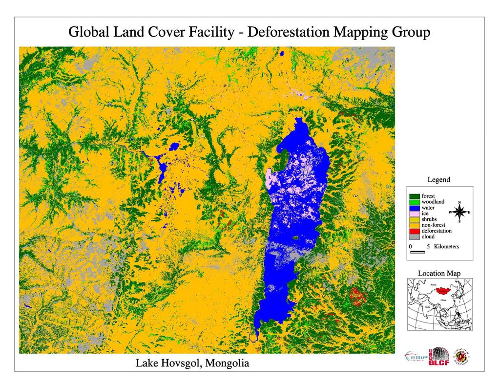
40 Hovsgol
41 Data Plan Data Plan New Methods Testing Landsat 4 & 5 TM images acquired through Landsat Pathfinder Project Extension to New Regions Landsat 7, EarthSat Geo-registered dataset, Landsat 4 & 5 Selected Ikonos scenes and other ultra-high resolution images
42 Data Plan Data Plan Landsat Images and classification products will be stored and distributed through the Global Land Cover Facility.
43 Work Schedule Work Schedule -Year 1 Landsat Pathfinder methods will be first tested in those extra-tropical areas most similar to the areas in tropical areas characterized by large scale clearance such as the clearance types in Paraguay discussed above. Test automated co-registration techniques and implement the most accurate and robust techniques based on our evaluation.
44 Work Schedule Work Schedule -Year 1 (cont d) Implement the pre-processing procedures associated with atmospheric correction and test the MTF effects for TM data to decide the pixel size to be used and whether deconvolution should be implemented. The improvements in unsupervised procedures will be tested and implemented.
45 Work Schedule Work Schedule -Year 2 Test the mixture modeling and supervised components of the approach to assess whether they bring substantial additional benefits. Assess Landsat Pathfinder methods including enhancements in test sites in the boreal zone.
46 Work Schedule Work Schedule -Year 3 The most spatially and temporally complex areas will be examined to assess whether processes provide sufficiently reliable performance. Investigate the contribution of coarser resolution data sets for improved characterization of forest types in terms of leaf type and duration. Participate with GOFC activities providing advice on how to improve the characterization and monitoring of forest cover.
47

48 Paraguay example
49 Tierras Bajas, Bolivia
50 Cochabamba, Bolivia
51 References
Mapping the Boreal zone forest cover and forest cover loss 2000 to 2005
 Matthew Hansen a, Peter Potapov a, Steve Stehman b, Kyle Pittman a, Thomas Loveland c, Mark Carroll d, Charlene DiMiceli d Mapping the Boreal zone forest cover and forest cover loss 2000 to 2005 a - South
The Global Land Cover Facility
 The Global Land Cover Facility REASoN Activities John Townshend, Principal Investigator Joseph JaJa, Co-Principal Investigator University of Maryland January 2004 The GLCF The GLCF research facility is
Forest change detection in boreal regions using
 Forest change detection in boreal regions using MODIS data time series Peter Potapov, Matthew C. Hansen Geographic Information Science Center of Excellence, South Dakota State University Data from the
Module 2.1 Monitoring activity data for forests using remote sensing
 Module 2.1 Monitoring activity data for forests using remote sensing Module developers: Frédéric Achard, European Commission (EC) Joint Research Centre (JRC) Jukka Miettinen, EC JRC Brice Mora, Wageningen
Monitoring Forest Change with Remote Sensing
 Monitoring Forest Change with Remote Sensing Curtis Woodcock (curtis@bu.edu) Suchi Gopal Scott Macomber Mary Pax Lenney Boston University (Dept of Geography and Center for Remote Sensing) Conghe Song (UNC,
Towards Methodologies for Global Monitoring of Forest Cover with Coarse Resolution Data
 Towards Methodologies for Global Monitoring of Forest Cover with Coarse Resolution Data R. DeFries M. Hansen J. Townshend R. Sohlberg M. Carroll C. DiMicelli University of Maryland, College Park Objective:
ESTIMATING TROPICAL DEFORESTATION IN THE CONGO BASIN BY SYSTEMATIC SAMPLING OF HIGH RESOLUTION IMAGERY
 Proceedings of the 2 nd Workshop of the EARSeL SIG on Land Use and Land Cover ESTIMATING TROPICAL DEFORESTATION IN THE CONGO BASIN BY SYSTEMATIC SAMPLING OF HIGH RESOLUTION IMAGERY Gregory Duveiller 1,
Operational Monitoring of Alteration in Regional Forest Cover Using Multitemporal Remote Sensing Data ( )
") Operational Monitoring of Alteration in Regional Forest Cover Using Multitemporal Remote Sensing Data (2000-2003) Janet Franklin Doug Stow John Rogan Lisa Levien Chris Fischer Curtis Woodcock Consultant:
Operational Monitoring of Alteration in Regional Forest Cover Using Multitemporal Remote Sensing Data (2000-2003) Janet Franklin Doug Stow John Rogan Lisa Levien Chris Fischer Curtis Woodcock Consultant:
Greenhouse Gas Emissions from Biomass Burning
 Global Fire Greenhouse Gas Emissions from Biomass Burning Chris Justice Geography Department Chris Justice GOFC/GOLD University Fire of Maryland IT co-chair University of Maryland Fires in Southern Africa,
K&C Phase 4 Brief project essentials
 K&C Phase 4 Brief project essentials Measuring above-ground biomass and its changes over Brazilian tropical secondary forests and savanna woodlands (Cerrado) using L-band SAR data Shaun Quegan, João Carreiras
Carbon in the Forest Biomass of Russia
 Carbon in the Forest Biomass of Russia Woods Hole Research Center R.A. Houghton Tom Stone Peter Schlesinger David Butman Oregon State University Olga Krankina Warren Cohen Thomas K. Maiersperger Doug Oetter
Monitoring Forest Dynamics in Northeastern China in Support of GOFC
 Monitoring Forest Dynamics in Northeastern China in Support of GOFC Principal Investigator: Dr. Guoqing Sun, University of Maryland Co-Principal Investigator: Dr. Darrel L. Williams, NASA s Goddard Space
Forest and Land Cover Monitoring by Remote Sensing Data Analysis
 Low Carbon Asia Research Network (LoCARNet) 3rd Annual Meeting Bogor, Indonesia November 24 26, 2014 Forest and Land Cover Monitoring by Remote Sensing Data Analysis Muhammad Ardiansyah Center for Climate
The GMES Forest Monitoring REDD Services Preparation of Sentinel 2 Applications
 Sentinel-2 for Science Workshop 21 May 2014, Frasacti The GMES Forest Monitoring REDD Services Preparation of Sentinel 2 Applications T. Haeusler, S.Gomez, G.Ramminger, R. Siwe Consortium led by: Project
MONITORING THE MESOAMERICAN BIOLOGICAL CORRIDOR: A NASA/CCAD COOPERATIVE RESEARCH PROJECT
 MONITORING THE MESOAMERICAN BIOLOGICAL CORRIDOR: A NASA/CCAD COOPERATIVE RESEARCH PROJECT Steven A. Sader (Principal Investigator) Department of Forest Management University of Maine (NAG5-8712) Orono,
AUTOMATED LAND COVER MAPPING AND INDEPENDENT CHANGE DETECTION IN TROPICAL FOREST USING MULTI-TEMPORAL HIGH RESOLUTION DATA SET
 AUTOMATED LAND COVER MAPPING AND INDEPENDENT CHANGE DETECTION IN TROPICAL FOREST USING MULTI-TEMPORAL HIGH RESOLUTION DATA SET A. Verhegghen a, *, C. Ernst a, P. Defourny a, R. Beuchle b a Earth and Life
Multi-sensor imaging of tree and water cover time-series at continental to global scales
 1 Multi-sensor imaging of tree and water cover time-series at continental to global scales Joe Sexton Min Feng, Saurabh Channan, John Townshend (PI) Global Land Cover Facility Department of Geographical
Generating Data from National Forest Monitoring
 Generating Data from National Forest Monitoring and Click Carbon to edit Accounting (REDD Master MRV) title style Alexander Lotsch Click to edit Master subtitle style World Bank Forest Carbon Partnership
Rapid Land Use and Land Cover Database Development
 Rapid Land Use and Land Cover Database Development Utility of the Land Use and Land Cover Database Socio-Economic Climate Change Water Quantity Water Quality 2 Overview of the Mapping Approach Goal: Develop
Forest Monitoring in Tropical Regions
 Forest Monitoring in Tropical Regions Manuela Hirschmugl & Mathias Schardt Institute of Digital Image Processing, Joanneum Research Content: 1. Background 2. Data 3. Methods 3.1. Pre-processing 3.2. Segmentation
A North-American Forest Disturbance Record from Landsat Imagery
 GSFC Carbon Theme A North-American Forest Disturbance Record from Landsat Imagery Jeffrey Masek, NASA GSFC Forrest G. Hall, GSFC & UMBC Robert Wolfe, GSFC & Raytheon Warren Cohen, USFS Corvallis Eric Vermote,
FOREST COVER MAPPING AND GROWING STOCK ESTIMATION OF INDIA S FORESTS
 FOREST COVER MAPPING AND GROWING STOCK ESTIMATION OF INDIA S FORESTS GOFC-GOLD Workshop On Reducing Emissions from Deforestations 17-19 April 2007 in Santa Cruz, Bolivia Devendra PANDEY Forest Survey of
GLOBAL FOREST LAND- USE CHANGE FROM 1990 TO 2010: AN UPDATE TO A GLOBAL REMOTE SENSING SURVEY OF FORESTS
 Forest Resources Assessment Working Paper 187 GLOBAL FOREST LAND- USE CHANGE FROM 1990 TO 2010: AN UPDATE TO A GLOBAL REMOTE SENSING SURVEY OF FORESTS The designations employed and the presentation of
Mapping Hemlocks to Estimate Potential Canopy Gaps Following Hemlock Woolly Adelgid Infestations in the Southern Appalachian Mountains
 Mapping Hemlocks to Estimate Potential Canopy Gaps Following Hemlock Woolly Adelgid Infestations in the Southern Appalachian Mountains Tuula Kantola, Maria Tchakerian, Päivi Lyytikäinen-Saarenmaa, Robert
MULTI-ANGULAR SATELLITE REMOTE SENSING AND FOREST INVENTORY DATA FOR CARBON STOCK AND SINK CAPACITY IN THE EASTERN UNITED STATES FOREST ECOSYSTEMS
 MULTI-ANGULAR SATELLITE REMOTE SENSING AND FOREST INVENTORY DATA FOR CARBON STOCK AND SINK CAPACITY IN THE EASTERN UNITED STATES FOREST ECOSYSTEMS X. Liu, M. Kafatos, R. B. Gomez, H. Wolf Center for Earth
Mapping the world s forests: work by FAO and partners in the global Forest Resource Assessment (FRA) Mette L. Wilkie Adam Gerrand FAO
 Mette L. Wilkie Adam Gerrand FAO") Mapping the world s forests: work by FAO and partners in the global Forest Resource Assessment (FRA) Mette L. Wilkie Adam Gerrand FAO www.fao.org/forestry/fra2010 Main points Challenges unprecedented global
Mapping the world s forests: work by FAO and partners in the global Forest Resource Assessment (FRA) Mette L. Wilkie Adam Gerrand FAO www.fao.org/forestry/fra2010 Main points Challenges unprecedented global
Background. Chapter (DeFries et al.) in IPAM/ED book (eds: Moutinho + Schwartzman)
 in IPAM/ED book (eds: Moutinho + Schwartzman)") Global Observation of Forest and Land Cover Dynamics Monitoring Deforestation for Compensated Reductions Martin Herold ESA GOFC-GOLD Land Cover Project Office FSU Jena, Germany on behalf of GTOS/GOFC-GOLD
Global Observation of Forest and Land Cover Dynamics Monitoring Deforestation for Compensated Reductions Martin Herold ESA GOFC-GOLD Land Cover Project Office FSU Jena, Germany on behalf of GTOS/GOFC-GOLD
Integration of forest inventories with remotely sensed data for biomass mapping: First results for tropical Africa
 Integration of forest inventories with remotely sensed data for biomass mapping: First results for tropical Africa Alessandro Baccini Nadine Laporte Scott J. Goetz Mindy Sun Wayne Walker Jared Stabach
Mapping paddy rice agriculture using multi-temporal. FORMOSAT-2 images
 Mapping paddy rice agriculture using multi-temporal FORMOSAT-2 images Y. S. SHIU, S. H.CHIANG, T. H. CHU and K. T. CHANG Department of Geography, National Taiwan University, Taipei, Taiwan Most paddy rice
Regional network activities
 Regional network activities Olga N. Krankina Oregon State University with contributions from Erik Lindquist (OSFAC) Dominick Kwesha (Miombo) Gerardo Lopez (RedLatif) 10/17/2008 Olga N. Krankina, OSU 1
Basic Concept of Early Warning System for Tropical Forest
 System for Monitoring of Tropical Forest Japan Pavilion, December 1, (13:00-14:00) Basic Concept of Early Warning System for Tropical Forest - Initiative for Improvement of Forest Governance by JICA/JAXA
A Remote Sensing Based Urban Tree Inventory for the Mississippi State University Campus
 A Remote Sensing Based Urban Tree Inventory for the Mississippi State University Campus W. H. Cooke III a and S.G. Lambert b a Geosciences Department, GeoResources Institute, Mississippi State University,
European Forest Fire Information System (EFFIS) - Rapid Damage Assessment: Appraisal of burnt area maps with MODIS data
 - Rapid Damage Assessment: Appraisal of burnt area maps with MODIS data") European Forest Fire Information System (EFFIS) - Rapid Damage Assessment: Appraisal of burnt area maps with MODIS data Paulo Barbosa European Commission, Joint Research Centre, Institute for Environment
European Forest Fire Information System (EFFIS) - Rapid Damage Assessment: Appraisal of burnt area maps with MODIS data Paulo Barbosa European Commission, Joint Research Centre, Institute for Environment
The role of remote sensing in global forest assessments. Introduction, objectives and alternative survey scenarios
 The role of remote sensing in global forest assessments Erkki Tomppo 1 and Ray Czaplewski 2 1 Finnish Forest Research Institute, National Forest Inventory Unioninkatu 40 A, FIN-00170 Helsinki, Finland
Impact of oil palm plantations on peatland conversion in Sarawak
 Impact of oil palm plantations on peatland conversion in Sarawak 2005-2010 January 2011 Commissioned by Wetlands International Cover image credit: ALOS satellite (left) EORC/JAXA, Aerial photo (right)
Role and importance of Satellite data in the implementation of the COMIFAC Convergence Plan
 Plenary Meeting of the Congo Basin Forest Partnership (CBFP) Palais des Congrès, Yaoundé. Cameroon 11-12 November, 2009 Role and importance of Satellite data in the implementation of the COMIFAC Convergence
Investigating ecological patterns and processes in tropical forests using GIS and remote sensing
 Investigating ecological patterns and processes in tropical forests using GIS and remote sensing Carlos Portillo-Quintero Center for Earth Observation Sciences (CEOS) Department of Earth & Atmospheric
Overview of new MODIS and Landsat data derived products to characterise land cover and change over Russia. Sergey BARTALEV
 Russian Academy of Sciences Space Research Institute (IKI) Overview of new MODIS and Landsat data derived products to characterise land cover and change over Russia Sergey BARTALEV 15 Aprile 2013, GOFC-GOLD
Detection of Deforestation in China and South East Asia using GF-1 time-series Data
 Detection of Deforestation in China and South East Asia using GF-1 time-series Data Project No.10549 Dr. Tan Bingxiang, Institute of Forest Resources Information Technique, CAF, Beijing, China Mike Wooding,
A Forest Cover Change Study Gone Bad
 A Forest Cover Change Study Gone Bad Lessons Learned(?) Measuring Changes in Forest Cover in Madagascar Ned Horning Center for Biodiversity and Conservation American Museum of Natural History (horning@amnh.com)
Mangrove deforestation analysis in Northwestern Madagascar Stage 1 - Analysis of historical deforestation
 Mangrove deforestation analysis in Northwestern Madagascar Stage 1 - Analysis of historical deforestation Frédérique Montfort, Clovis Grinand, Marie Nourtier March 2018 1. Context and study area : The
EVALUATING THE ACCURACY OF 2005 MULTITEMPORAL TM AND AWiFS IMAGERY FOR CROPLAND CLASSIFICATION OF NEBRASKA INTRODUCTION
 EVALUATING THE ACCURACY OF 2005 MULTITEMPORAL TM AND AWiFS IMAGERY FOR CROPLAND CLASSIFICATION OF NEBRASKA Robert Seffrin, Statistician US Department of Agriculture National Agricultural Statistics Service
Remote sensing as a tool to detect and quantify vegetation properties in tropical forest-savanna transitions Edward Mitchard (University of Edinburgh)
") Remote sensing as a tool to detect and quantify vegetation properties in tropical forest-savanna transitions Edward Mitchard (University of Edinburgh) Presentation to Geography EUBAP 10 th Oct 2008 Supervisor:
Remote sensing as a tool to detect and quantify vegetation properties in tropical forest-savanna transitions Edward Mitchard (University of Edinburgh) Presentation to Geography EUBAP 10 th Oct 2008 Supervisor:
Tropical forest degradation monitoring using ETM+ and MODIS remote sensing data in the Peninsular Malaysia
 IOP Conference Series: Earth and Environmental Science OPEN ACCESS Tropical forest degradation monitoring using ETM+ and MODIS remote sensing data in the Peninsular Malaysia To cite this article: M Hashim
Forestry Department Food and Agriculture Organization of the United Nations FRA 2000 GLOBAL FOREST COVER MAPPING FINAL REPORT.
 Forestry Department Food and Agriculture Organization of the United Nations FRA 2000 GLOBAL FOREST COVER MAPPING FINAL REPORT Rome, 2001 Forest Resources Assessment Programme Working Paper 50 Rome 2001
Monitoring Natural Sal Forest Cover in Modhupur, Bangladesh using Temporal Landsat Imagery during
 Monitoring Natural Sal Forest Cover in Modhupur, Bangladesh using Temporal Landsat Imagery during 1972 2015 Hasan Muhammad Abdullah *, M. Golam Mahboob, Md.Mezanur Rahman, Tofayel Ahmed * Assistant Professor,
Available online at Received 15 November 2006; received in revised form 18 July 2007; accepted 21 July 2007
 Available online at www.sciencedirect.com Remote Sensing of Environment 112 (2008) 1969 1981 www.elsevier.com/locate/rse Deforestation in Central Africa: Estimates at regional, national and landscape levels
Processing Multitemporal TM Imagery to Extract Forest Cover Change Features in Cleveland National Forest, Southern California
 Processing Multitemporal TM Imagery to Extract Forest Cover Change Features in Cleveland National Forest, Southern California John Rogan and Janet Franklin San Diego State University Thanks to Lisa Levien:
FORMA: Forest Monitoring for Action
 FORMA: Forest Monitoring for Action FORMA uses freely-available satellite data to generate rapidly-updated online maps of tropical forest clearing. We have designed it to provide useful information for
MOSAICKING. Affiliation: European Commission DG Joint Research Centre. Method
 MOSAICKING Affiliation: European Commission DG Joint Research Centre Geocoding using: Method JAXA slant range 50 m HH+HV detected data + SCANSAR data SRTM, GTOPO elevation data JAXA orbital data Radiometric
Evolution and Priorities for NASA Land Cover and Land Use Change Program
 Evolution and Priorities for NASA Land Cover and Land Use Change Program NASA LCLUC Science Team Meeting 15 th Anniversary University of Maryland 28 March 2011 Anthony C. Janetos, Director Joint Global
Forest Boundary Mapping Using Multi-Temporal Satellite Images in Forested Areas of North Iran
 Forest Boundary Mapping Using Multi-Temporal Satellite Images in Forested Areas of North Iran Ali A. DARVISHSEFAT & Farokh POURSHAKOURI, Iran Key words: multi-temporal images, SPOT5, ASTER, forest boundary,
JRC future activities: TropForest and ReCaREDD projects
 JRC future activities: TropForest and ReCaREDD projects Presented by Frédéric Achard www.jrc.ec.europa.eu First High level objective of the FRC unit Assessment of the state and condition (extent, health
THE IMPACTS OF URBANIZATION ON THE SURFACE ALBEDO IN THE YANGTZE RIVER DELTA IN CHINA
 THE IMPACTS OF URBANIZATION ON THE SURFACE ALBEDO IN THE YANGTZE RIVER DELTA IN CHINA 08/24/2011 Mélanie Bourré Motivation Since the 20th century, rapid urbanization of the world population. United Nation
Forestry Department Food and Agriculture Organization of the United Nations FRA 2000 GLOBAL FOREST COVER MAP. Rome, November 1999
 Forestry Department Food and Agriculture Organization of the United Nations FRA 2000 GLOBAL FOREST COVER MAP Rome, November 1999 Forest Resources Assessment Programme Working Paper 19 Rome 1999 The Forest
30 Years of Tree Canopy Cover Change in Unincorporated and Incorporated Areas of Orange County,
 30 Years of Tree Canopy Cover Change in Unincorporated and Incorporated Areas of Orange County, 1986-2016 Final Report to Orange County July 2017 Authors Dr. Shawn Landry, USF Water Institute, University
Monitoring deforestation & land cover change in the Santa Cruz region of Bolivia using Landsat satellite imagery
 2014 Monitoring deforestation & land cover change in the Santa Cruz region of Bolivia using Landsat satellite Alterra Wageningen 6-1-2014 Title: MONITORING DEFORESTATION & LAND COVER CHANGE IN THE SANTA
An Urban Classification of Khartoum, Sudan
 An Urban Classification of Khartoum, Sudan Project Summary and Goal: The primary goal of this project was to delineate the urban extent of Khartoum, Sudan from a Landsat ETM+ image captured in 2006. In
CHARACTERIZATION OF THE AREAS IN SUCCESSION PROCESS (REGROWTH) IN THE AMAZON REGION
 IN THE AMAZON REGION") CHARACTERIZATION OF THE AREAS IN SUCCESSION PROCESS (REGROWTH) IN THE AMAZON REGION Iris de Marcelhas e Souza Iris@ltid.inpe.br Yosio Edemir Shimabukuro Yosio@ltid.inpe.br Valdete Duarte Valdte@ltid.inpe.br
CHARACTERIZATION OF THE AREAS IN SUCCESSION PROCESS (REGROWTH) IN THE AMAZON REGION Iris de Marcelhas e Souza Iris@ltid.inpe.br Yosio Edemir Shimabukuro Yosio@ltid.inpe.br Valdete Duarte Valdte@ltid.inpe.br
Object-oriented Classification and Sampling Rate of Landsat TM Data for Forest Cover Assessment. Yasumasa Hirata 1, Tomoaki Takahashi 1
 Object-oriented Classification and Sampling Rate of Landsat TM Data for Forest Cover Assessment Yasumasa Hirata 1, Tomoaki Takahashi 1 1 Forest Management Department, Forestry and Forest Products Research
Assessment of areas of selective logging and burned forests in Mato Grosso State, Brazil, from satellite imagery
 XIV WORLD FORESTRY CONGRESS, Durban, South Africa, 7-11 September 2015 Assessment of areas of selective logging and burned forests in Mato Grosso State, Brazil, from satellite imagery Yosio Edemir Shimabukuro
FOREST AND FOREST CHANGE MAPPING WITH C- AND L-BAND SAR IN LIWALE, TANZANIA
 FOREST AND FOREST CHANGE MAPPING WITH C- AND L-BAND SAR IN LIWALE, TANZANIA J. Haarpaintner a, C. Davids a, H. Hindberg a, E. Zahabu b, R.E. Malimbwi b a Norut, P.O. Box 6434, Tromsø Science Park, N-9294
Problem. Land should be paid in order to reduce deforestation. Particularly challenging to turn data into useful information / country statistics
 FAO / Norway SEPAL April 2016 Problem Deforestation in the tropics constitutes of 15-20% of global greenhouse gas emissions (GHG) Reduction of GHG needed to achieve the two-degree target Norway advocates
Assessing Forest Degradation using Time Series of Fine Spatial Resolution Imagery in Africa
 Assessing Forest Degradation using Time Series of Fine Spatial Resolution Imagery in Africa A. Verhegghen, B. Desclée, H. Eva, P. Mayaux, F. Achard European Commission Joint Research Centre Sentinel-2
Forests Introduction and Historical Context. International Forestry John Sessions
 Forests Introduction and Historical Context International Forestry John Sessions Overview What is a Forest? Importance of Forests Forest Classification Human Impact on Forests Historical Overview Sources:
Dryland Degradation: What Should We Monitor and How? Alan Grainger School of Geography, University of Leeds
 Dryland Degradation: What Should We Monitor and How? Alan Grainger School of Geography, University of Leeds Who Needs Information? Who Needs Information? All the bodies who need information on the drylands
Identification of Crop Areas Using SPOT 5 Data
 Identification of Crop Areas Using SPOT 5 Data Cankut ORMECI 1,2, Ugur ALGANCI 2, Elif SERTEL 1,2 1 Istanbul Technical University, Geomatics Engineering Department, Maslak, Istanbul, Turkey, 34469 2 Istanbul
Towards an operational MODIS continuous field of percent tree cover algorithm: examples using AVHRR and MODIS data
 Remote Sensing of Environment 83 (2002) 303 319 www.elsevier.com/locate/rse Towards an operational MODIS continuous field of percent tree cover algorithm: examples using AVHRR and MODIS data M.C. Hansen
An Assessment of the Pull between Landuse and Landcover in Southwestern Nigeria and the Ensuing Environmental Consequences
 An Assessment of the Pull between Landuse and Landcover in Southwestern Nigeria and the Ensuing Environmental Consequences R.O. OYINLOYE and J. OLOUKOI INTRODUCTION HYDRO SPHERE ATMO SPHERE BIO SPHERE
Progress Report for COMBINED SATELLITE MAPPING OF SIBERIAN LANDSCAPES: NATURAL AND ANTHROPOGENIC FACTORS AFFECTING CARBON BALANCE
 Progress Report for COMBINED SATELLITE MAPPING OF SIBERIAN LANDSCAPES: NATURAL AND ANTHROPOGENIC FACTORS AFFECTING CARBON BALANCE Submitted to : Dr. Garik Gutman, LCLUC Program Manger Dr. Waleed Ablati,
Linking Remote Sensing and Economics: Evaluating the Effectiveness of Protected Areas in Reducing Tropical Deforestation
 Linking Remote Sensing and Economics: Evaluating the Effectiveness of Protected Areas in Reducing Tropical Deforestation Joe Maher 1 and Xiaopeng Song 2 1 University of Maryland, Department of Agricultural
Effects of the Development of the Baikal-Amur Mainline Railroad on Patterns of Boreal Forest Cover and Carbon Fluxes in Southern Siberia
 Effects of the Development of the Baikal-Amur Mainline Railroad on Patterns of Boreal Forest Cover and Carbon Fluxes in Southern Siberia Eric Kasischke (Co-Principal Investigator) Kathleen Bergen, Nancy
Forest Dragon 3 Project Id
 Forest Dragon 3 Project Id. 10666 Principle Investigator: Co-Investigator: Young Scientists: Prof. Li, Academy of Forest Sciences Prof. Schmullius, University of Jena Prof. Pang, Dr. Feilong, Dr. Santoro
Challenges for MRV in agroforestry systems using remote sensing techniques Hans Fuchs
 Challenges for MRV in agroforestry systems using remote sensing techniques Hans Fuchs DAAD Workshop Dubai and Doha 27.11 2.12.2012 Contents Agroforestry and REDD+ Classification of agroforestry systems
Forest Change Caused by Wind, Water, Ice, Fire, Insects/Disease & Harvesting
 Forest Change Caused by Wind, Water, Ice, Fire, Insects/Disease & Harvesting Why use remote sensing for mapping forest changes? Synoptic view of damage on a forest landscape or regional level. Can stop
REDDAF. Infosheet. Content. Objective and Concept. November 2012
 November 2012 REDDAF Infosheet Content Objective and Concept Objective and Concept 1 User Requirements 2 Methods Development 2 Service Development 5 Validation and Proof of Concept 6 Capacity Building/Training
USING REMOTELY SENSED DATA TO MAP FOREST AGE CLASS BY COVER TYPE IN EAST TEXAS
 USING REMOTELY SENSED DATA TO MAP FOREST AGE CLASS BY COVER TYPE IN EAST TEXAS Daniel Unger 1, I-Kuai Hung, Jeff Williams, James Kroll, Dean Coble, Jason Grogan 1 Corresponding Author: Daniel Unger (unger@sfasu.edu)
Image Classification I
 Image Classification I Classification is the process of labeling image pixels using predetermined categorical classes. Components: Image features Classification scheme Signatures Training Classifiers Classification
REMOTE SENSING APPLICATION IN FOREST ASSESSMENT
 Bulletin of the Transilvania University of Braşov Series II: Forestry Wood Industry Agricultural Food Engineering Vol. 4 (53) No. 2-2011 REMOTE SENSING APPLICATION IN FOREST ASSESSMENT A. PINEDO 1 C. WEHENKEL
Changing Dynamics of Tropical Deforestation and Atmospheric Carbon: Science Meets Policy PLEASE DO NOT USE GRAPHICS WITHOUT PERMISSIONS
 Changing Dynamics of Tropical Deforestation and Atmospheric Carbon: Science Meets Policy R. DeFries, University of Maryland College Park Michigan State University, March 18, 2008 Collaborators G. Van der
Using Open Data and New Technology To Tackle the Greening of the CAP from a broader perspective
 Using Open Data and New Technology To Tackle the Greening of the CAP from a broader perspective Prague, 21 st of October Marcel Meijer & Jeroen van de Voort Outline Setting the scene Open Data related
Monitoring Condition of Savanna Riparian Zones in North Australia
 Monitoring Condition of Savanna Riparian Zones in North Australia Centre for Remote Sensing and Spatial Information Science Kasper Johansen Centre for Remote Sensing and Spatial Information Science School
UNITED NATIONS NATIONS UNIES
 UNITED NATIONS NATIONS UNIES FRAMEWORK CONVENTION ON CLIMATE CHANGE - Secretariat CONVENTION - CADRE SUR LES CHANGEMENTS CLIMATIQUES - Secrétariat Working paper No. 1 (a) (2006) 17 August 2006 Workshop
Analysis of rapid land-use/land-cover change in North-eastern China using Landsat TM/ETM+ data
 Ecosystems and Sustainable Development V 553 Analysis of rapid land-use/land-cover change in North-eastern China using Landsat TM/ETM+ data K. Okamoto 1, J. Shindo 1 & H. Kawashima 2 1 National Institute
Research projects of Landuse changes in Latvia
 Research projects of Landuse changes in Latvia Ilmars Krampis University of Latvia, faculty of Geography and Earth Science Juris Zariņš Latvian State Forest Research Institute "Silava" Joint NASA LCLUC
Change Detection of Forest Vegetation using Remote Sensing and GIS Techniques in Kalakkad Mundanthurai Tiger Reserve - (A Case Study)
") , Vol 9(30), DOI: 10.17485/ijst/2016/v9i30/99022, August 2016 ISSN (Print) : 0974-6846 ISSN (Online) : 0974-5645 Change Detection of Forest Vegetation using Remote Sensing and GIS Techniques in Kalakkad
, Vol 9(30), DOI: 10.17485/ijst/2016/v9i30/99022, August 2016 ISSN (Print) : 0974-6846 ISSN (Online) : 0974-5645 Change Detection of Forest Vegetation using Remote Sensing and GIS Techniques in Kalakkad
Different Methods To Estimate Above. Study From Nepal
 Different Methods To Estimate Above Ground dbiomass: A Comparative Study From Nepal A Comparative Study from Nepal Data Comparing 4 different methods to extrapolate LiDAR estimated carbon to landscape
WATERSHED LAND COVER CHANGE IN GUAM. Yuming Wen Shahram Khosrowpanah Leroy F. Heitz
 WATERSHED LAND COVER CHANGE IN GUAM Yuming Wen Shahram Khosrowpanah Leroy F. Heitz Technical Report No. 124 March 2009 Watershed Land Cover Change in Guam by Yuming Wen Shahram Khosrowpanah Leroy F. Heitz
Rapid loss of Paraguay's Atlantic forest and the status of protected areas A Landsat assessment
 Remote Sensing of Environment 106 (2007) 460 466 www.elsevier.com/locate/rse Rapid loss of Paraguay's Atlantic forest and the status of protected areas A Landsat assessment Chengquan Huang a,, Sunghee
Production of the Missouri Land Cover Data Layer Brief Notes 1/00 DRAFT
 Production of the Missouri Land Cover Data Layer Brief Notes 1/00 DRAFT This land cover data layer was derived from Thematic Mapper (TM) satellite data from 1991, 1992, and 1993 (listed below). For most
DUE preparatory activities for Sentinel 2 exploitation: Agriculture, Land Cover Change, Costal Monitoring, Forest Mapping
 DUE preparatory activities for Sentinel 2 exploitation: Agriculture, Land Cover Change, Costal Monitoring, Forest Mapping Fostering the development and validation of EO applications with and for user communities
Forestry and Agricultural Greenhouse Gas Modeling Forum # Shepherdstown, WV
 Forestry and Agricultural Greenhouse Gas Modeling Forum #4 March 6-8, 6 2007 Shepherdstown, WV Overview of scientific, technical and methodological issues related to reducing emissions from deforestation
IV. RESULT AND DISCUSSION
 IV. RESULT AND DISCUSSION The result of forest cover change simulation during 4 years was described. This process is done by using the information of land cover condition obtained from satellite imagery
Overview of Land Surface Parameters From Earth Observation
 Overview of Land Surface Parameters From Earth Observation Prof. Dr. Christiane Schmullius Friedrich Schiller University Jena, Germany Department of Geoinformatics and Remote Sensing FSU Jena Institut
FORESTS FOR TOMORROW PILOT PROJECT FINAL SYNOPSIS
 FORESTS FOR TOMORROW PILOT PROJECT FINAL SYNOPSIS Identification and prioritization of backlog openings for incremental silviculture investment opportunities using remote sensing techniques Proponent Name:
Identifying and and Understanding Carbon Cycle Implications of of North American Natural and and Anthropogenic Disturbances:
 Identifying and and Understanding Carbon Cycle Implications of of North American Natural and and Anthropogenic Disturbances: 1982-2005 Progress Progress Report Report NRA-04-OES-01 NRA-04-OES-01 Christopher
2. DEVELOPMENT OF A FOREST MONITORING SYSTEM UTILIZING REMOTE SENSING TECHNOLOGY
 2. DEVELOPMENT OF A FOREST MONITORING SYSTEM UTILIZING REMOTE SENSING TECHNOLOGY 2. Development of a Forest Monitoring System utilizing Remote Sensing Technology 2.1. Outline of Technology Development
Opportunities and challenges for monitoring tropical deforestation and forest degradation in dynamic landscapes using Sentinel-2!
 Sentinel-2 For Science Workshop 20-22 May, 2014 ESA-ESRIN Frascati Opportunities and challenges for monitoring tropical deforestation and forest degradation in dynamic landscapes using Sentinel-2 Dirk
Global Burnt Area Products
 Global Burnt Area Products Kevin Tansey Department of Geography, University of Leicester, UK kevin.tansey@le.ac.uk Structure Why burnt area estimation is important Challenges to global burnt area mapping
REMOTE SENSING NEEDS FOR STATE FORESTRY AGENCIES:
 REMOTE SENSING NEEDS FOR STATE FORESTRY AGENCIES: A VIRGINIA PERSPECTIVE John A. Scrivani Research Forester Virginia Department of Forestry Presented at the LCLUC Science Team Meeting on GOFC and Disturbance,