Using General Land Office Survey Records in Ecosystem Restoration Planning
|
|
|
- Archibald Allen
- 6 years ago
- Views:
Transcription
 surveys can be used to help guide ecosystem restoration planning.")


1 Using General Land Office Survey Records in Ecosystem Restoration Planning by Marie Perkins, Charles Klimas, Joseph Dunbar, Thomas Foti, and Jody Pagan PURPOSE: This technical note describes how records from General Land Office (GLO) surveys can be used to help guide ecosystem restoration planning. The GLO surveys were conducted in the 18th and 19th centuries, prior to the extensive settlement of the United States frontier regions. Throughout much of the newly independent United States, the GLO surveyors recorded information on hydrography and terrain, as well as specific data on vegetation composition and structure. When these notes and measurements are transferred to a Geographic Information System (GIS) and overlain on modern maps and aerial photographs, the information can provide insight into both natural and man-made changes that have occurred to the physical and biological environment of a region. This historical information can aid ecologists in establishing a reference condition for a study area and can help to define opportunities for ecosystem restoration. That process is illustrated here using the GLO survey data for a unique wetland complex called Grassy Lake (Figure 1) in southwestern Arkansas. Figure 1. Typical views of Grassy Lake in the Lower Little River Basin of southwestern Arkansas. The Grassy Lake ecosystem includes areas of lowland hardwood forest, cypress swamp, and open water.
2 BACKGROUND: Reference ecosystems are commonly used to guide restoration planning and evaluate restoration success. Reference conditions can be compared to existing conditions for a variety of ecosystem features, allowing ecologists to define opportunities for restoration, recognize situations where elements of the original system are no longer restorable, and determine where alternative restoration targets are more appropriate. Ecologists typically use the least disturbed or minimally disturbed conditions as a basis for comparison, and use the best remaining examples of a particular ecosystem type for points of reference. Ideally, that would include relatively pristine systems that show little or no direct human influence since the time of European settlement. Such places are rare, but the records of the original GLO surveys often supply information that can be used to describe that undisturbed condition. The GLO surveys were initiated in 1785 to provide a basis for dividing and selling public lands within the newly established United States. Teams of surveyors were dispatched to various parts of the country to establish township, range, and section boundary lines according to a detailed set of guidelines (Bureau of Land Management 2009). The basic survey unit was the six-mile-square township, which was identified by a distance north or south of an east-west running Base Line, and east or west of the north-south running Meridian. Townships were subdivided into 36 onesquare-mile sections (Figure 2) and again into quarter sections (Figure 3). Figure 2. A schematic of a six-mile-square township, subdivided into 36 one-square-mile sections. 2
3 Figure 3. A schematic of 4 one-mile-square sections, illustrating the section corners and the quarter section corners. Linear measures were recorded in chains (80 per mile) and areas in acres (640 per section). Specific guidance for how surveys were conducted and which data were recorded changed periodically (Stewart 1935), but the survey records always included two basic types of information: survey notes and plat maps. As the surveyors measured the section boundaries, they made detailed handwritten notes on the environmental features and landmarks they encountered and recorded their locations (Figure 4). They used these notes to create plat maps of the townships, which illustrate the location of major landscape features such as lakes and rivers (Figure 5). The most detailed data in the survey notes concern forest composition and structure, including measurements of individual trees (Dodds et al. 1943). Surveyors recorded the species and diameter of two or more trees along the survey line between quarter section corners. More detailed data were collected for bearing trees (sometimes called witness trees) at each ½ mile and 1 mile interval; these intervals correspond to the quarter section and section corners identified in Figure 3. Bearing tree data included species and diameter, as well as distance and direction from the line. These data also were recorded for two bearing trees at each fractional corner; these were points where obstacles, such as water bodies, prohibited the surveyors from continuing along the 3
4 survey line. At each mile or half-mile interval (depending on the prevailing guidance) the surveyors briefly characterized the surrounding landscape, including the topography, the predominant vegetation, the quality of the soil, and whether the area was fit for cultivation. If the line crossed a bottomland, the surveyors determined whether the bottomland was prone to flooding and estimated the flood depth. The surveyors also recorded hydrographic information. They were instructed to describe all rivers, streams, creeks, and springs that intersected the survey lines and to note their direction of flow and width (Dodds et al. 1943). They were also instructed to note other water features, such as swamps, ponds, and lakes, and to indicate when the survey line entered or exited a river bottom or creek bottom. Navigable rivers were surveyed along their entire banklines, and large lakes were surveyed along their perimeters. Based on these surveys and on extrapolations between survey points, plat maps were created that depict the approximate size and location of all water bodies in each township (see Figure 5). Figure 4. The surveyor s handwritten notes for the line between sections 29 and 30 of Township 12 South (T12S) and Range 27 West (R27W), which encompasses Grassy Lake. This information was recorded on December 17th,


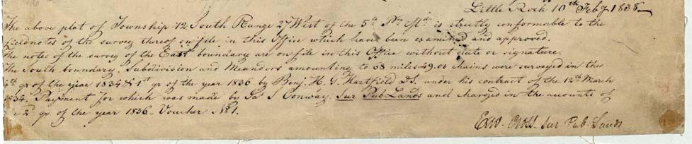
5 Figure 5. The plat map for T12S R27W showing the various landscape features the surveyors encountered, including Grassy Lake. 5

6 ERDC TN-EMRRP-EBA-9 CASE STUDY: GRASSY LAKE INTRODUCTION: The Lower Little River Bottoms ecosystem is a complex of approximately 15,000 acres of lowland hardwood forest and an extensive bald cypress swamp known as Grassy Lake. Located in the alluvial valley of the Little River in southwestern Arkansas, just downstream from the U.S. Army Corps of Engineers (USACE) dam that impounds Millwood Lake, it is one of the largest contiguous tracts of diverse bottomland forest remaining in the Gulf Coastal Plain Region of the United States (Figure 6). It is particularly well-known as a traditional waterfowl hunting area (Figure 7), and private landowners have protected it for that purpose from the intensive forestry and agricultural activities that have altered the surrounding landscape. Figure 6. Digital orthophotograph of the study area showing selected major physiographic and cultural features. Little River was impounded to form Millwood Lake, in the northwest corner of the image. The dynamic flood patterns that influenced the area were dramatically changed in the mid-20th century when the federal government, through the USACE, built a series of dams specifically for flood control on the Red River and its tributaries, including streams in the Little River drainage 6

7 basin. These structures, particularly Millwood Dam, effectively disconnected the floodplain ecosystem from the Little River in all but extreme flood events. At about the same time, private landowners began to substantially modify the adjacent uplands and major contributing local watersheds, changing the pattern of local runoff and increasing sediment inputs to the system. Although natural flooding was largely curtailed, the lands within the Lower Little River Bottoms, almost all of which are within private hunting clubs, were modified using levees, pumps, and drainage structures so that water could be detained or diverted into the lowland forests and Grassy Lake and managed for waterfowl hunting and fishing. These modifications substantially raised water levels within Grassy Lake, and altered natural flood patterns in most of the bottomland and swamp forests. After more than a half century, the effects of these man-made changes are evident in degraded hardwood stands, aquatic weed problems, and lack of cypress reproduction. Figure 7. Waterfowl hunter at Grassy Lake in In 2004, Congress directed the Little Rock District, USACE, to initiate an Ecosystem Restoration Feasibility Study of the Grassy Lake area under Section 1135 of the Water Resources Development Act. Subsequent investigations verified that the water control projects in the Little River drainage basin had adversely affected the entire Lower Little River Bottoms ecosystem, including Grassy Lake. The U.S. Army Engineer Research and Development Center (ERDC) was enlisted by the District to work with the state and local stakeholders to devise an ecosystem 7
8 restoration plan for the region. An essential part of this restoration plan was to identify the historical, pre-dam conditions of the study area. Characterizing the pre-dam environment involved investigations of three major ecosystem components: hydrology, geomorphology, and the distribution of native plant communities. The GLO plat maps and survey notes for the study area provided information about the historical condition for all three of these ecosystem components. METHODS: Prior to the initiation of this study, the Arkansas State Land Surveyor s Office had transcribed the original handwritten GLO survey notes for the entire state, indexed them, and made them available as digital files (Daniels 2000). The GLO surveys for the study area were undertaken from 1819 through 1842, with the surveys of Grassy Lake occurring in For this study, the transcribed GLO survey notes for the study area were entered into an Excel spreadsheet, including the entire townships of T12S R27W and T13S R27W and portions of the adjacent townships. Most landscape features and their locations were entered on a separate line in the spreadsheet, and each tree description was given its own line. However, the hydrologic features and general landscape descriptions often were combined with the tree data when they occurred at the same location. Each line in the spreadsheet was given a unique identifier and the distance at which the features occurred along the survey line was recorded in the distance column. Other location information, such as the township and range, the section number, the side of the section (e.g. south or east), and the direction the surveyor walked, were recorded in the spreadsheet. Tree species, tree diameter in inches, and the direction and distance to bearing trees were included. The type and name of hydrologic features, such as lakes and rivers, feature width, and bearing were recorded in the spreadsheet. All other non-numerical survey information, including general descriptions of the landscape and land ownership, was recorded within the spreadsheet as comments associated with particular survey points. A raster image showing the section boundary lines for the region was obtained from GeoStor (GeoStor ). This layer, created by the USGS, is a digital depiction derived from USGS 1:100,000-scale 30- by 60-minute quadrangle maps. This raster layer was then added into an ArcMap 9.3 (ESRI 2008) map document. Using this layer as a reference, points were digitized at the section corners and saved as a vector shapefile. The UTM coordinates of these section corners were determined using ArcMap. Since the surveyors measured along the section lines from the section corners, the landscape features in the survey notes can be located in GIS by relating them to those section corners. The UTM coordinates for the corner section from which each landscape feature was measured were also entered into the Excel spreadsheet, creating X_origin and Y_origin columns. The bearing from the section corners was also needed to digitize the survey notes. The surveyors recorded the cardinal direction in which they walked; the exact bearing for these were then determined using the grid layer to be: North = 2.2, South = 182.1, West = 272.3, and East = These were then included as a bearings column in the spreadsheet. Once the survey notes were entered into the spreadsheet, they were transferred to a GIS shapefile using two extensions, Distance/Azimuth Tools, v. 1.6 (Jenness 2005) and Script/Dialog Tools, v (Jenness 2007), in ArcView 3.3 (ESRI 2002). First the Excel spreadsheet was converted into a dbase table using the Script/Dialog Tools extension. This table was then converted to an event theme, using the X_origin and Y_origin columns as the X field and Y field. The 8
9 Distance/Azimuth Tools extension was then used to create a point shapefile from the table containing the survey notes. This extension provides a variety of methods for creating shapefiles; for this project the method used was the INPUT THEME, using unique distances and azimuths. The event theme created above was used as the Input Theme, the distance column was used as the Distance field, and the bearing column was used as the Azimuth field. (Note: the above steps also can be accomplished in current versions of ArcGIS using the Survey Analyst software extension). All of the attribute fields from the spreadsheet were transferred to the new point shapefile, which was added as a layer into ArcMap, along with the digital versions of the plat maps for the townships. Once the survey notes and plat maps were georeferenced in ArcMap, the surveyors observations could be analyzed and compared with current conditions in the study area. The GLO descriptions and data were used to reconstruct pre-settlement conditions, including mapping the vegetation and the positions of streams, characterizing flooding conditions, and contributing key data to the detailed hydrologic modeling of the pre-dam landscape. These analyses were used to identify the fundamental changes that had occurred in ecosystem structure and processes. They were also used to determine the extent to which those changes are reversible, and if not, what alternative conditions can be established and maintained. The resulting ecosystem restoration plan (Klimas et al. 2010) includes specific recommendations for forest management, reforestation, stream restoration, and an experimental approach for developing a dynamic water management plan that will sustain the Lower Little River Bottoms and Grassy Lake ecosystem. RESULTS AND DISCUSSION: The GLO surveyors reported few signs of human activity within the wilderness of the Lower Little River Bottoms. Like most of southwestern Arkansas, the area was only sparsely settled when the GLO survey was conducted, and no large-scale land clearing or other extensive human alterations had taken place. Therefore, the conditions reported in the survey notes represent a reasonable approximation of the undisturbed (pre-settlement) reference condition for the ecosystem. The GLO survey observations form a grid across the study area, providing information at regular intervals concerning line trees, bearing trees, water features, and the surveyors general descriptions of the landscape (Figure 8). The survey data and plat maps identified the historical positions of streams and rivers; comparing these to the current locations confirmed that most had not been modified and only minor natural shifts in channel position had occurred. However, the survey data verified that one major stream had been straightened and rerouted to significantly alter its interaction with Grassy Lake, causing accelerated sedimentation of the lake. Based on that analysis, restoration of the original stream channel became a major component of the final ecosystem restoration plan for the area. The GLO data also provided details about the native plant communities observed by the surveyors, allowing specific comparisons with the modern vegetation distribution pattern. Much of the bottomlands show little or no change in tree species composition since the early 1800s, but in the uplands, GLO surveyors noted expanses of prairie and open woodlands, indicating fire was a more common influence than it is currently. Based on this information, prescribed fire in the uplands is a recommended component of the ecosystem restoration plan. 9

10 ERDC TN-EMRRP-EBA-9 Figure 8. The distribution of observations made by the GLO surveyors, superimposed on a recent image of the Lower Little River Bottoms. The narrative descriptions of land condition and flood depths that appear in the GLO survey records were useful in reconstructing the pre-dam hydrology of the study area. For example, the surveyors recorded the following concerning part of one survey line within Grassy Lake: Land in Lake covered with water from 1 to 4 feet deep and in places very miry, some locust, cypress in spots. Undergrowth saw grass and button bushes. Descriptions such as these verified historical flooding of the bottomlands and provided a snapshot of conditions within Grassy Lake. However, a full characterization of inundation depths and durations based on hydrologic modeling was needed to guide the ecosystem restoration water management plan. This was accomplished for most of the bottomlands using pre-dam flow records for the Little River, but for Grassy Lake itself, additional data were needed. 10
11 Grassy Lake differs from the rest of the Little River lowlands in that it is actually a cypress swamp in a topographic basin, rather than a floodplain hardwood forest. The hydrology of the Grassy Lake basin is driven more by runoff from a local tributary, Yellow Creek (see Figure 6), and evapotranspiration than by overbank flows from the Little River. Under pre-development conditions, Grassy Lake would have had much of its substrate exposed for extended periods and at regular intervals. This is essential for cypress reproduction, though enough permanent water was present in deeper areas for the GLO surveyors to refer to the entire swamp as a lake. The levees and water control structures that were built in the mid-20th century were used to deepen, expand, and maintain the permanent pool sufficiently to support game fish populations and to allow flooding of the adjacent hardwood forests to attract waterfowl during hunting season. The objective of the hydrologic modeling process for Grassy Lake was to develop a water management plan that emulates the natural patterns of water fluctuation that once sustained the cypress swamp. However, the hydrologic modeling process lacked a key piece of information - the original full pool level and storage volume of the lake prior to the extensive construction of levees and drainage structures, which had obliterated evidence of the elevation of the original lake outlet. The GLO data were used to supply that critical information. Although the GLO surveyors sometimes surveyed the entire perimeter of a body of water, they did not do so for Grassy Lake. The lakeshore depicted on the plat map (Figure 5) is an approximation based on extrapolation between actual survey points. By using the original survey points in conjunction with modern topographic information in GIS, a much more accurate approximation of the original shoreline was created. The reconstructed shoreline nonetheless reflects only the water level that was present in the lake at the time the surveyors conducted their field work; it cannot be assumed to represent the full pool level or any other benchmark that can be used to recommend future water level management designed to re-establish the hydrologic patterns that sustained the original ecosystem. Therefore, the GLO tree data were closely examined to determine whether the shoreline contour calculated from the original GLO data represented the natural full pool condition for the swamp, or whether the contour should be adjusted either upward or downward. Figure 9 compares the current contour elevation of Grassy Lake at full pool and the lower, original shoreline contour as calculated from the GLO survey data, and illustrates the positions and species of trees observed at each of the original survey points within the modern lake boundary. Table 1 summarizes the distribution of those tree species between the modern full-pool lake perimeter and estimated original (or historical) lake level, and below the historical pool level. All of the trees observed by the surveyors within the historical lake boundary were species normally found in cypress swamps. They include cypress, which tolerates extended periods of flooding, as well as locust (presumably water locust), willow, buttonbush, and ash (presumably green ash); all can survive extended inundation for some time once they are established. However, all of these species require exposed substrates to germinate, and all but cypress and buttonbush require an extended dry period following germination to establish well enough to persist through subsequent floods. Regardless of whether these less-tolerant species are able to establish, they typically will not survive years where flooding remains through the growing season. This happens often enough in cypress swamps to maintain dominance by cypress and/or tupelo. The relative sizes of the trees listed in Table 1 tend to verify that species other than 11

12 ERDC TN-EMRRP-EBA-9 Figure 9. Approximate current and historical full pool perimeters of Grassy Lake showing the positions of individual trees observed by the GLO surveyors. cypress and buttonbush are not long-term components of the swamp forest. All of the largediameter trees within the pool at the time of the survey were bald cypress, including individuals that could have been present for a century or more; all other tree species were relatively small, indicating they had been present for only a decade or two at most. Conversely, the trees in the zone above the historical pool level were primarily species tolerant of normal seasonal river flooding overcup oak, hackberry, persimmon which occurred in the area prior to dam construction, but are not able to survive the long-term inundation typical of a cypress swamp. The sizes of those trees (Table 1) indicate that some also had been present for a century or more; therefore, seasonal flooding had been the prevailing pattern for at least that long. Today, none of those species are present within the current lake full pool perimeter instead, cypress and willow occupy that zone. 12
13 Table 1. Species and diameters of trees identified in Figure 9 as recorded by the GLO surveyors. Current Lake Boundary Historic Lake Boundary Tree Species Diameter (in.) Tree Species Diameter (in.) Locust 12 Willow 10 Overcup Oak 28 Button Willow 5 Overcup Oak 12 Button Wood 4 Overcup Oak 13 Locust 8 Overcup Oak 14 Cypress 24 Overcup Oak 13 Locust 7 Spanish Oak 16 Ash 8 Overcup Oak 16 Willow 10 Ash 9 Cypress 18 Ash 5 Cypress 16 Hackberry 8 Cypress 17 Persimmon 8 Willow 8 Ash 10 Locust 12 Locust 8 Locust 12 Sweet Gum 24 Elm 10 White Oak 24 Elm 7 This analysis verified that the estimated historical lake contour does in fact represent the natural full-pool elevation of Grassy Lake. It also confirmed that the hydrologic patterns commonly seen in cypress swamps likely also occurred in Grassy Lake generally shallow water conditions, but with regular substrate exposure during dry periods, sometimes extending for multiple years, allowing regeneration of the cypress forest as well as establishment of other, less water-tolerant, species. Just as there were extended dry periods, there were times when flooding continued throughout the growing season and for multiple years, sufficient to kill the less tolerant species. The ecosystem restoration plan derived from these observations stipulates a much more dynamic water fluctuation pattern than the one that has been employed since the lake level was raised in the mid-20th century. Regular substrate exposure will be required to maintain cypress regeneration and vigor. Drawdowns are currently avoided, in part to help sustain fisheries and to ensure water availability during waterfowl season; therefore, the restoration plan includes hydrologic modifications to restore some of the historical stream flows and provide other water sources into the lake so that managers can manipulate water levels and emulate natural fluctuation patterns as needed, without losing traditional waterfowl habitat. The artificial fish habitat that was created by converting the swamp to a true lake likely will not be compatible with ecosystem restoration goals. GLO survey data can be used for more detailed vegetation analyses than were needed at Grassy Lake (Bourdo 1956, Brothers 1991). In many instances, ecosystem restoration requires reforestation of large tracts of land that have been converted to agriculture, and the GLO tree data can be used to determine the appropriate species composition for various restoration sites. The 13
14 bearing tree data include species, diameter, distance from the survey line, and direction from the line. These are the same data collected in point-quarter sampling, a standard method in forest ecology (Cottam and Curtis 1956). By using this approach and linking the summarized forest community descriptions to their associated site data (such as soils, flood frequency, and geomorphology) the GLO data can provide a template for reforestation over large areas. This method also can be used to detect major changes that have occurred within existing forests due to timber harvest, fire exclusion, flood control, and other influences. Tingle et al. (2001) provide an example of this type of application for a portion of the Mississippi Alluvial Valley in eastern Arkansas. CONCLUSIONS: GLO survey notes and plat maps are an important information source for establishing the historical reference condition that can be used in ecosystem restoration. GLO surveys were conducted in 30 states: Alabama, Alaska, Arizona, Arkansas, California, Colorado, Florida, Idaho, Illinois, Indiana, Iowa, Kansas, Louisiana, Michigan, Minnesota, Mississippi, Missouri, Montana, Nebraska, Nevada, New Mexico, North Dakota, Ohio, Oklahoma, Oregon, South Dakota, Utah, Washington, Wisconsin, and Wyoming. Information about General Land Office surveys, as well as many of the survey notes and plat maps can be obtained from the Bureau of Land Management This website does not have all of the survey notes available, and most of the available notes are scanned copies of the original handwritten notes. However, many of the handwritten notes were transcribed (typed) in the 20th century, making them easier to interpret. Another resource for the survey notes and plat maps are state land offices. Some states also have the survey notes available online. In searching for information about the General Land Office surveys, it is important to note that these surveys are also often referred to as the Public Land Survey System (PLSS). ACKNOWLEDGEMENTS: Jeff Jenness of Jenness Enterprises was instrumental in converting the GLO survey notes to a GIS shapefile, and provided the two ArcView extensions used for this project. More information about Jenness Enterprises and these extensions can be found at POINT OF CONTACT: Charles Klimas, CEERD-EE-W, Charles.V.Klimas@erdc.usace.army. mil. ADDITIONAL INFORMATION: The analysis described in this publication was conducted as part of the Ecosystem Restoration Feasibility Study for the Grassy Lake area of southwestern Arkansas, authorized by Congress in 2004 under Section 1135 of the Water Resources Development Act. Julia Smethhurst, Little Rock District, Corps of Engineers, was Project Manager. This technical note was prepared as an activity of the Ecosystem Management and Restoration Research Program (EMRRP). For information on EMRRP, please consult army.mil/emrrp/emrrp.html or contact the Program Manager, Glenn Rhett, at Glenn.G.Rhett@ usace.army.mil. This technical note should be cited as follows: Perkins, M., C. V. Klimas, J. Dunbar, T. Foti, and J. Pagan Using general land office survey records in ecosystem restoration planning. EBA Technical Notes Collection. ERDC TN-EMRRP-EBA-9. Vicksburg, MS: U.S. Army 14
15 Engineer Research and Development Center. emrrp.html REFERENCES Bourdo, E. A., Jr A review of the General Land Office Survey and of its use in quantitative studies of former forests. Ecology 37: Brothers, T. S The U.S. General Land Office Survey as a basis for biogeography exercises. Journal of Geography 90: Bureau of Land Management General Land Office Records (accessed December 2, 2009). Cottam, G., and J. T. Curtis The use of distance measures in phytosociological sampling. Ecology 37: Daniels, C Arkansas original General Land Office survey notes and plats. Arkansas State Land Office: Little Rock, AR (16 compact disks). Dodds, J. S., L. P. McKean, L. O. Stewart, and G. F. Tigges Original instructions governing public land surveys of Iowa. Ames, IA: Iowa Engineering Society. ESRI ArcView Version 3.3. Redlands, CA: ESRI Corporation. ESRI ArcMap Version 9.3. Redlands, CA: ESRI Corporation. GeoStor Arkansas Official GIS Platform (accessed June ). Jenness Distance/Azimuth Tools (dist_az_tools.avx) extension for ArcView 3.x, v Jenness Enterprises. Jenness Script and Dialog Tools (script_tools_jen.avx) extension for ArcView 3.x, v Jenness Enterprises. Klimas, C. V., T. Foti, J. Dunbar, J. Pagan, and M. Perkins Analysis and recommendations for restoration of the Grassy Lake and Lower Little River Bottoms ecosystem. Vicksburg, MS: U.S. Army Engineer Research and Development Center. Report to the U.S. Army Corps of Engineers District, Little Rock. Stewart, L. O Public land surveys history, instructions, methods. Ames, IA: Collegiate Press, Inc. Tingle, J. L., C. V. Klimas, and T. L. Foti Application of General Land Office Survey notes to bottomland hardwood ecosysteme management and restoration in the Lower Mississippi Valley An example from Desha County, Arkansas. Chapter. In Bottomland Hardwoods of the Mississippi Allucvial Valley: Characteristics and Management of Natural Function, Structure, and Composition Technical Report SRS 42, ed. P. B. Hamel and T. L. Foti, Asheville, NC: USDA Forest Service Southern Research Station General. NOTE: The contents of this technical note are not to be used for advertising, publication, or promotional purposes. Citation of trade names does not constitute an official endorsement or approval of the use of such products. 15
Initial Application of a Landscape Evolution Model to a Louisiana Wetland
 Initial Application of a Landscape Evolution Model to a Louisiana Wetland by Carl F. Cerco PURPOSE: Corps planning projects encompass a wide variety of restoration goals. These include wetland restoration,
Watershed Condition Framework
 US Forest Service - Watershed Condition Classification Maps http://www.fs.fed.us/publications/watershed/ Page 1 of 2 1/9/2013 Watershed Condition Framework The Forest Service has released the first national
PROSPECTUS. Proposed Beech River Canal Wetland and Stream Mitigation Bank
 PROSPECTUS Proposed Beech River Canal Wetland and Stream Mitigation Bank INTRODUCTION This prospectus provides an overview of Beech River Farms, LLC s (BRF) proposed Beech River Canal Wetland and Stream
Restoring The Delta: Partnerships For Sustainable
 Lower Mississippi Valley Largescale Watershed Project ANNUAL REPORT FY 2001 Restoring The Delta: Partnerships For Sustainable Restoration In the Lower Mississippi Alluvial Valley I. Partnership Overview
Forest Resources of the United States, 2017: A Technical Document Supporting the Forest Service Update of the 2010 RPA Assessment
 Forest Resources of the United States, 2017: A Technical Document Supporting the Forest Service Update of the 2010 RPA Assessment Abstract Oswalt, Sonja N.; Miles, Patrick D.; Pugh, Scott A.; Smith, W.
A Study of United States Hydroelectric Plant Ownership
 INL/EXT-06-11519 A Study of United States Hydroelectric Plant Ownership Douglas G. Hall, INL Project Manager Kelly S. Reeves, NPS June 2006 The INL is a U.S. Department of Energy National Laboratory operated
Appendix E Part 4 Hydrogeomorphic (HGM) Assessment of Alternatives for the St. Johns Bayou Basin and New Madrid Floodway Project
 Assessment of Alternatives for the St. Johns Bayou Basin and New Madrid Floodway Project") Appendix E Part 4 Hydrogeomorphic (HGM) Assessment of Alternatives for the St. Johns Bayou Basin and New Madrid Floodway Project U.S. Army Corps of Engineers Memphis District WORKING DRAFT AS OF 6-17-12
Appendix E Part 4 Hydrogeomorphic (HGM) Assessment of Alternatives for the St. Johns Bayou Basin and New Madrid Floodway Project U.S. Army Corps of Engineers Memphis District WORKING DRAFT AS OF 6-17-12
11/8/2016. Topography and Vegetation. Natural Levee. Seasonally Flooded Hardwood Bottomlands
 Seasonally Flooded Hardwood Bottomlands River Birch Black Willow Cottonwood Topography and Vegetation Water Hickory Overcup Oak Water Elm Water Tupelo Baldcypress Overcup Oak Green Ash Red Maple Low Back-
Webinar for the Natural Floodplain Function Alliance 18 November 2013
 Moving toward Floodplain Restoration at Scale on the Illinois River and Upper Mississippi Basin: Valuing Ecosystem Services, Demonstrating Flood Reduction, and Policy Implications Webinar for the Natural
Forest Resources of the United States, 2017:
 Forest Resources of the United States, 2017: A Technical Document Supporting the Forest Service 2020 update of the RPA Assessment Abstract Oswalt, Sonja N.; Miles, Patrick D.; Pugh, Scott A.; Smith, W.
SW-74 SERENOVA PRESERVE SITES 2, 3, 4, 8 MITIGATION PLAN
 SW-74 SERENOVA PRESERVE SITES 2, 3, 4, 8 MITIGATION PLAN BACKGROUND INFORMATION Project SWIM? Aquatic Control? Exotic Control? Mitigation Bank? Type No No No No Mitigation Restoration and enhancement Type
TURKEY RIVER BOTTOMS DELTA AND BACKWATER COMPLEX
 TURKEY RIVER BOTTOMS DELTA AND BACKWATER COMPLEX HABITAT REHABILITATION AND ENHANCEMENT PROJECT CLAYTON COUNTY, IOWA AND GRANT COUNTY, WISCONSIN UPPER MISSISSIPPI RIVER RESTORATION ENVIRONMENTAL MANAGEMENT
Collaborative Forest Landscape Restoration Program
 Collaborative Forest Landscape Restoration Program Meg Roessing U.S.D.A. Forest Service Forest Management Staff Washington Office mroessing@fs.fed.us Background: Department and Agency Priority Our shared
Streamflow of 2013 Water Year Summary
 Streamflow of 23 Water Year Summary U.S. Geological Survey Reston, Virginia January 24 23 Statewide Streamflow Ranks (93 23) Introduction National Overview Regional Patterns Seasonal Characteristics High
BOSTON BAY HABITAT REHABILITATION AND ENHANCEMENT PROJECT (HREP) MERCER COUNTY, ILLINOIS
 MERCER COUNTY, ILLINOIS") BOSTON BAY HABITAT REHABILITATION AND ENHANCEMENT PROJECT (HREP) MERCER COUNTY, ILLINOIS UPPER MISSISSIPPI RIVER RESTORATION ENVIRONMENTAL MANAGEMENT PROGRAM ROCK ISLAND DISTRICT FACT SHEET I. LOCATION
BOSTON BAY HABITAT REHABILITATION AND ENHANCEMENT PROJECT (HREP) MERCER COUNTY, ILLINOIS UPPER MISSISSIPPI RIVER RESTORATION ENVIRONMENTAL MANAGEMENT PROGRAM ROCK ISLAND DISTRICT FACT SHEET I. LOCATION
Walton Family Foundation Freshwater Initiative Strategy
 Walton Family Foundation Freshwater Initiative Strategy This document summarizes the five year strategy for the Walton Family Foundation s Freshwater Initiative. This strategy was adopted by the Foundation
Meacham Creek Restoration Project
 Meacham Creek Restoration Project Meacham Creek Restoration Project Umatilla National Forest Walla Walla Ranger District Michael Rassbach, District Ranger Public Scoping Document Proposal Summary The Walla
THE MISSISSIPPI RIVER TRUST
 THE MISSISSIPPI RIVER TRUST Operates as a land trust in six states along the Lower Mississippi River. Primary tool is the conservation easement, which allows willing landowners to protect important ecological
EXECUTIVE SUMMARY DES PLAINES RIVER WATERSHED-BASED PLAN WHY A WATERSHED-BASED PLAN? WHAT IS A WATERSHED?
 Des Plaines River Watershed-Based Plan EXECUTIVE SUMMARY June 2018 EXECUTIVE SUMMARY DES PLAINES RIVER WATERSHED-BASED PLAN WHY A WATERSHED-BASED PLAN? Water is elemental to our lives. Plants and animals,
Upper Mississippi River. Systemic Forest Stewardship Plan. Executive Summary
 Upper Mississippi River Systemic Forest Stewardship Plan Executive Summary St. Paul District Rock Island District St. Louis District August 2012 Introduction The Mississippi River is the largest riverine
WETLANDS AND OPEN WATERS Compensatory Mitigation Definitions of Factors
 Adverse effects as used in this section of the SOP means any adverse ecological effect on wetlands or areas of open water. Those effects, or impacts, include filling, excavating, flooding, draining, clearing,
MIDDLE MISSISSIPPI RIVER (MMR) REGIONAL CORRIDOR
 REGIONAL CORRIDOR") MIDDLE MISSISSIPPI RIVER (MMR) REGIONAL CORRIDOR Illinois Missouri General Expense Project Proposal For Comprehensive Analyses of Multi-jurisdictional Use and Management of Water Resources on a Watershed
MIDDLE MISSISSIPPI RIVER (MMR) REGIONAL CORRIDOR Illinois Missouri General Expense Project Proposal For Comprehensive Analyses of Multi-jurisdictional Use and Management of Water Resources on a Watershed
FOREST MANAGEMENT PLAN For the GLADDEN MEMORIAL WOODLAND
 FOREST MANAGEMENT PLAN For the GLADDEN MEMORIAL WOODLAND Prepared by Don Carlson-Purdue University Forester DECEMBER 2003 1. Legal Description and Location The Purdue University Claude M. Gladden Memorial
Minnesota EAW Supplement
 Appendix I: Minnesota EAW Supplement Lower Pool 2 Channel Management Study: Boulanger Bend to Lock and Dam No. 2 Minnesota EAW Item Identification A supplement prepared for the Minnesota DNR to identify
Stormwater Erosion Control & Post-Construction Plans (Stormwater Quality Plans)
") Stormwater Erosion Control & Post-Construction Plans (Stormwater Quality Plans) Allen County Stormwater Plan Submittal Checklist The following items must be provided when applying for an Allen County Stormwater
Stormwater Erosion Control & Post-Construction Plans (Stormwater Quality Plans) Allen County Stormwater Plan Submittal Checklist The following items must be provided when applying for an Allen County Stormwater
AMERICAN FORESTRY CONGRESS
 PROCEEDINGS OF THE AMERICAN FORESTRY CONGRESS AT ITS MEETING HELD IN BOSTON, SEPTEMBER 1885 WASHINGTON DC JUDD & DETWILLER, PRINTERS FACTS AND FIGURES IN RESPECT TO THE FORESTS OF THE COUNTRY AND THEIR
Wetland Functions in the Watershed: Part 1 Watershed Elements. USDA NRCS Module Name 1
 Wetland Functions in the Watershed: Part 1 Watershed Elements USDA NRCS Module Name 1 Objectives Define Landscape Elements in the Watershed Describe Hydrologic Connections Between Elements Introduce Soil
Prioritizing restoration activities for salmonid habitat within a watershed
 Prioritizing restoration activities for salmonid habitat within a watershed Author: Lisa Lackey Co-author: Laurel Marcus Abstract Maacama Creek, a tributary of the Russian River has 45 miles of tributary
Invasive Species There is an App and a Map for That
 Invasive Species There is an App and a Map for That Who am I? Information Technology Director Public Service Assistant in Entomology B.S. and M.S. in Computer Science President - National Exotic Pest Plant
HOW BIG IS AFRICA? Rules. recommended grades: 3-6
 AFRICA HOW BIG IS AFRICA? recommended grades: 3-6 time needed: 25 MINUTES Description Students develop a sense of scale by using their bodies and other tools to measure the length and width of Africa.
2.4 Floodplain Restoration Principles
 Floodplain Restoration Principles 2.4 Floodplain Restoration Principles Anthropogenic alternation of river corridors and floodplains significantly modified the structure and function of landscapes and
The Pyrogeographyof Wildfires in the Western U.S.
 The Pyrogeographyof Wildfires in the Western U.S. Dr. Michael Medler 1 2 3 4 The pumps buy you time, but minutes only. From this moment, no matter what we do, Titanic will founder. But this ship can't
Capacity Building Through the Watershed Approach
 Capacity Building Through the Watershed Approach Mississippi Department of Environmental Quality (MDEQ) and US Environmental Protection Agency, Region 4 (USEPA, R4) MDEQ Process 1. Develop water quality
GIS Analysis of Gully Head Erosion Rates on High Ridge Tree Farm in Winona County, Minnesota
 GIS Analysis of Gully Head Erosion Rates on High Ridge Tree Farm in Winona County, Minnesota Lisa M. Worrell Department of Resource Analysis, Saint Mary s University of Minnesota, Winona, MN 55987. Keywords:
Federal and State Water Law. Jennifer Gimbel, CSU Grad592 October 29, 2018
 Federal and State Water Law Jennifer Gimbel, CSU Grad592 October 29, 2018 Desert Land Act and Homestead Act Federal Lands and Indian Reservations Federal Reserved Water Rights Doctrine Established for
Forestland Stewards 2018 Grant Slate
 NFWF CONTACT Jonathan Scott Program Director, Southern Forests jonathan.scott@nfwf.org 202-595-2609 Red-cockaded woodpecker Credit: Mary Snieckus ABOUT NFWF The National Fish and Wildlife Foundation (NFWF)
* For applicants utilizing bank for compensatory mitigation requirements, information below is not applicable.
 Mitigation Plan (33 CFR 332.4(c)/40 CFR 230.92.4(c)) A mitigation plan is required for all forms of compensatory mitigation, whether permittee-responsible mitigation, mitigation banks, or in-lieu fee mitigation
Background. Literature Review
 Ms. Joanna Helms Economic Development Director Town of Apex 73 Hunter Street P.O. Box 250 Apex, North Carolina 27502 October 23, 2015 Reference: Report of Wetland Determination Cash Perkins Site ECS Project
ANALYZING REGIONAL FIA DATA IN THE ARCVIEW GEOGRAPHIC INFORMATION SYSTEM 1
 ANALYZING REGIONAL FIA DATA IN THE ARCVIEW GEOGRAPHIC INFORMATION SYSTEM 1 David Reed, Scott Pugh, Pat Miles, and Kurt Pregitzer 2 Abstract The ArcView Geographic Information System (GIS) is probably the
Missouri River Recovery Program Shallow Water Habitat Accounting Summary Report. Kansas City District Omaha District 2014
 Missouri River Recovery Program Shallow Water Habitat Accounting Summary Report Kansas City District Omaha District 2014 THIS PAGE INTENTIONALLY LEFT BLANK Contents 1.0 Introduction... 1 1.1 Overview...
Public Notice Corps of Engineers
 Public Notice US Army Corps of Engineers Memphis District REPLY TO ATTN: Roger Allan U.S. Army Corps of Engineers 167 North Main Street, Room B-202 Memphis, Tennessee 38103-1894 Telephone: (901) 544-3682
U.S. Drought Monitor, August 28, 2012
 University of Nebraska - Lincoln DigitalCommons@University of Nebraska - Lincoln US Ag in Drought Archive Drought -- National Drought Mitigation Center 8-28-2 U.S. Drought Monitor, August 28, 2 Brian Fuchs
U.S. Drought Monitor, September 4, 2012
 University of Nebraska - Lincoln DigitalCommons@University of Nebraska - Lincoln US Ag in Drought Archive Drought -- National Drought Mitigation Center 9--12 U.S. Drought Monitor, September, 12 Brian Fuchs
Public Notice APPLICATION NO.: EVALUATOR: PHONE NO.: FAX NO.: DATE: EXPIRATION DATE:
 US Army Corps of Engineers. Vicksburg District 4155 Clay Street Vicksburg, MS 39183-3435 www.mvk.usace.army.mil Public Notice APPLICATION NO.: EVALUATOR: PHONE NO.: FAX NO.: E-MAIL: DATE: EXPIRATION DATE:
Summary of Management Recommendations
 Location and Description This property is owned by Anthony Day, 14426 NW 83 rd Lane, Alachua, FL 32615. The property is located in Section 18, Township 1 North, Range 6 East, in eastern Jefferson County,
Presenter: CLYDE HUNT. Project Manager Memphis District August 2010
 Presenter: CLYDE HUNT Project Manager Memphis District 24-25 August 2010 US Army Corps of Engineers Memphis District Brief History Secretary Westphal ASA (Civil Works) received several letters from the
U.S. Drought Monitor, July 31, 2012
 University of Nebraska - Lincoln DigitalCommons@University of Nebraska - Lincoln US Ag in Drought Archive Drought -- National Drought Mitigation Center -3-2 U.S. Drought Monitor, July 3, 2 Mark D. Svoboda
MANAGING CARBON DIOXIDE THROUGH FORESTRY
 MANAGING CARBON DIOXIDE THROUGH FORESTRY Gary Kaster, American Electric Power Mike Rodenberg, DTE Energy Eric Kuhn, Cinergy Paul Pike, Ameren John Kinsman, Edison Electric Institute USDA Greenhouse Gas
Ocklawaha River Restoration as Mitigation
 Ocklawaha River Restoration as Mitigation Dredging Will Further Harm the St. Johns Salinity = Farther Upstream Impacting Wetlands Damaging Submerged Grasses Further Stressing Trees Altering Dissolved Oxygen
4. Present Activities and Roles
 4. Present Activities and Roles The present missions, authorities, activities and roles of the various agencies involved with flood protection, floodplain management and flood-damage reduction are identified
2015 Reinvest in Minnesota (RIM) Reserve Wetlands Program
 Reserve Wetlands Program") 2015 Reinvest in Minnesota (RIM) Reserve Wetlands Program Site Evaluation Form Instructions Document 12/31/14 This instructions document is to be used for guidance in completing the Site Evaluation Form
2015 Reinvest in Minnesota (RIM) Reserve Wetlands Program Site Evaluation Form Instructions Document 12/31/14 This instructions document is to be used for guidance in completing the Site Evaluation Form
Wetland Losses and Human Impacts
 Wetland Losses and Human Impacts Matthew J. Gray University of Tennessee Distribution of North American Wetlands Peatlands of Alaska and Canada Hudson and James Bay Wetlands Prairie Potholes Great Lakes
Report. Environmental Water Demands. Butte County Department of Water and Resource Conservation Integrated Water Resources Plan.
 Report Butte County Department of Water and Resource Conservation Integrated Water Resources Plan s June 2004 s Section 1 - Introduction 1.1 Project Description This project is a preliminary investigation
States Use Gentle Hand in Taxing Timberland
 March 2009 No. 164 FISCAL FACT States Use Gentle Hand in Taxing Timberland By Travis Greaves In the realm of real property taxation, the best-known tax is on residential property. Every U.S. homeowner
ENVIRONMENTAL ASSESSMENT
 ENVIRONMENTAL ASSESSMENT, FINDING OF NO SIGNIFICANT IMPACT, and DECISION RECORD 1 ENVIRONMENTAL ASSESSMENT EA Number: OR-080-05-10 BLM Office: Marys Peak Resource Area, Salem District Office 1717 Fabry
Upper Iowa Watershed at a Glance
 Upper Iowa Watershed at a Glance This story was made with Esri's Story Map Journal. Read the interactive version on the web at https://arcg.is/0y54t8. Esri, HERE, Garmin, FAO, NOAA, USGS, EPA The Mississippi
The DNR is charged with managing waters resources to assure an adequate and sustainable supply for multiple uses.
 The DNR is charged with managing waters resources to assure an adequate and sustainable supply for multiple uses. Minnesota Laws 2015, chapter 4, article 4, directed the Department of Natural Resources
Final Report of the Riparian Forest Buffer Panel
 Chesapeake Bay Program Final Report of the Riparian Forest Buffer Panel Introduction Findings Land Use-Specific Findings On Agricultural Land On Forested Land On Developed and Developing Lands Recommendations
COMMONWEALTH OF PENNSYLVANIA DEPARTMENT OF ENVIRONMENTAL PROTECTION
 COMMONWEALTH OF PENNSYLVANIA DEPARTMENT OF ENVIRONMENTAL PROTECTION PERMIT GUIDELINES FOR PHASED NPDES STORMWATER DISCHARGES ASSOCIATED WITH CONSTRUCTION ACTIVITY PERMITS, CHAPTER 102 EROSION AND SEDIMENT
INDIAN CREEK WATERSHED PLAN EXECUTIVE SUMMARY
 INDIAN CREEK WATERSHED PLAN EXECUTIVE SUMMARY The Indian Creek Watershed covers a 38 square mile area in southern Lake County, Illinois that drains 24,116 acres before discharging into the Des Plaines
Appendix I. Potential Adverse Change to Wetland Function Methodology and Results
 Appendix I Potential Adverse Change to Wetland Function Methodology and Results Technical Memorandum North Florida Regional Water Supply Plan Potential Adverse Change to Wetland Function January 3, 2017
Feasibility Report with Integrated Environmental Assessment Rip Rap Landing HREP APPENDIX M MONITORING & ADAPTIVE MANAGEMENT PLAN
 Feasibility Report with Integrated Environmental Assessment APPENDIX M MONITORING & ADAPTIVE MANAGEMENT PLAN Feasibility Report with Integrated Environmental Assessment INTENTIONALLY LEFT BLANK Feasiblity
What is an ecosystem?
 What is an ecosystem? An ecosystem is generally defined as a community of organisms living in a particular environment and the physical elements in that environment with which they interact. (http://www.enviroliteracy.org/category.php/3.html)
LIVING LANDS Helping Land Trusts Conserve Biodiversity
 LIVING LANDS Helping Land Trusts Conserve Biodiversity Habitat Restoration: Information for Land Trusts What is Habitat Restoration? Habitat restoration is defined as the process of assisting the recovery
CATEGORY a protection of the natural environment, its ecosystems and biodiversity.
 29. ENVIRONMENTAL DEVELOPMENT PERMIT AREA CATEGORY a protection of the natural environment, its ecosystems and biodiversity. The requirement to obtain an environmental development permit is cited in Section
Guidelines for Conducting and Reporting Hydrologic Assessments of Potential Wetland Sites
 Wetlands Regulatory Assistance Program ERDC TN-WRAP-00-01 Guidelines for Conducting and Reporting Hydrologic Assessments of Potential Wetland Sites PURPOSE: This technical note provides guidance on performing
U.S. Drought Monitor, October 2, 2012
 University of Nebraska - Lincoln DigitalCommons@University of Nebraska - Lincoln US Ag in Drought Archive Drought -- National Drought Mitigation Center -2-12 U.S. Drought Monitor, October 2, 12 Anthony
Maine s Land Use Regulations and Erosion Control Techniques
 Maine s Land Use Regulations and Erosion Control Techniques Protecting Maine s Air, Land and Water Colin Clark 441-7419 colin.a.clark@maine.gov Tom Gilbert 441-8031 thomas.gilbert@maine.gov Jim Rodrigue
The Denver Water System
 The Denver Water System Established in 1918 Unique structure Serves 1.3 million people 25% of Colorado s population System footprint - 4,000 square miles (2.5 million acres) 19 raw water reservoirs Critical
Proposed Action. A Land-for-Land Exchange between American Land Holdings of Illinois, LLC and the Shawnee National Forest.
 United States Department of Agriculture Forest Service December 2011 Proposed Action A Land-for-Land Exchange between American Land Holdings of Illinois, LLC and the Shawnee National Forest Shawnee National
Decision Memo for Pax Ponderosa Pine Planting Project
 Decision Memo for Pax Ponderosa Pine Planting Project USDA Forest Service Pacific Northwest Region Fremont-Winema National Forests Lakeview Ranger District Lake County, Oregon Introduction The Lakeview
EPA Stormwater Update
 EPA Stormwater Update Ken Moraff 3/27/13 http://www.flickr.com/photos/chefmattrock/4780312471/ Massachusetts 2010 Rhode Island 2010 Vermont 2011 http://www.flickr.com/photos/tomswift/6102959612/ Charles
Land Values 2013 Summary
 United States Department of Agriculture National Agricultural Statistics Service Land Values 2013 Summary August 2013 ISSN: 19491867 Contents Agricultural Land Values Highlights... 4 Farm Real Estate,
CHARLES SOIL CONSERVATION DISTRICT COMPLIANCE AGREEMENT FOR THE STANDARD EROSION AND SEDIMENT CONTROL PLAN FOR FOREST HARVEST OPERATIONS
 CHARLES SOIL CONSERVATION DISTRICT COMPLIANCE AGREEMENT FOR THE STANDARD EROSION AND SEDIMENT CONTROL PLAN FOR FOREST HARVEST OPERATIONS I. Site Information A. Location (Include site map of harvest area)
Prospectus for the Lower Saline River Mitigation Bank Cleveland County, Arkansas. Arkansas State Highway and Transportation Department
 Prospectus for the Lower Saline River Mitigation Bank Cleveland County, Arkansas Arkansas State Highway and Transportation Department June 2012 The Arkansas State Highway and Transportation Department
Shoreland Rules Revision Project Using GIS in North-Central Minnesota
 Shoreland Rules Revision Project Using GIS in North-Central Minnesota Andrew J. Williquett Department of Resource Analysis, Saint Mary s University of Minnesota, Minneapolis, MN 55404 Keywords: GIS, docks,
National Inventory of Dams Overview
 National Inventory of Dams Overview NID Data Team 27 Oct 2016 US Army Corps of Engineers NID Definition Congressionally authorized database documenting dams in the United States and its territories Maintained
DECISION MEMO LOWER STILLWATER FISHERY ENHANCEMENT U.S. FOREST SERVICE DUCHESNE RANGER DISTRICT ASHLEY NATIONAL FOREST DUCHESNE COUNTY, UTAH
 DECISION MEMO LOWER STILLWATER FISHERY ENHANCEMENT U.S. FOREST SERVICE DUCHESNE RANGER DISTRICT ASHLEY NATIONAL FOREST DUCHESNE COUNTY, UTAH BACKGROUND The Rock Creek drainage is a very popular recreation
KESWICK DAM RED BLUFF REACH
 Chapter 3 KESWICK DAM RED BLUFF REACH The Keswick-Red Bluff Reach of the Sacramento River, the upper-most reach of the Conservation Area, is unique in many ways. The reach extends from Keswick Dam (about
PRESENTERS. Contact Information: RW Armstrong Union Station, 300 S. Meridian St. Indianapolis, IN
 1 PRESENTERS David Bourff, Director of Environmental Planning Simon Davies, LEED AP, Environmental Scientist Summer O Brien, PWS, Senior Environmental Scientist Contact Information: RW Armstrong Union
Gulf Hypoxia and the Mississippi River Basin Healthy Watershed Initiative
 Gulf Hypoxia and the Mississippi River Basin Healthy Watershed Initiative Presented by: Mike Sullivan, Arkansas State Conservationist Mississippi/Atchafalaya River Basin 2008 Action Plan Goals 4 1. Coastal
Managed wetland impoundments: history, distribution, management strategies for wildlife
 Managed wetland impoundments: history, distribution, management strategies for wildlife Sara H. Schweitzer Warnell School of Forestry & Natural Resources University of Georgia 1 Agrarian Rice Era in the
SPATIAL ANALYSIS OF POTENTIAL IMPACTS OF LOCAL FORESTRY ORDINANCES
 SPATIAL ANALYSIS OF POTENTIAL IMPACTS OF LOCAL FORESTRY ORDINANCES David R. Daversa, Stephen P. Prisley, and Michael J. Mortimer Department of Forestry, Virginia Tech, Blacksburg, VA 24061 ABSTRACT Local
U.S. Census Bureau Lumber Production and Mill Stocks MA321T(07) Issued May 2008
 Issued May 2008") U.S. Census Bureau Lumber Production and Mill Stocks - 2007 MA321T(07) Issued May 2008 Address inquiries concerning these data to Primary Goods Industries Branch, U.S. Department of Commerce, Census Bureau,
U.S. Census Bureau Lumber Production and Mill Stocks - 2007 MA321T(07) Issued May 2008 Address inquiries concerning these data to Primary Goods Industries Branch, U.S. Department of Commerce, Census Bureau,
LAKE SHELBYVILLE MASTER PLAN KASKASKIA RIVER WATERSHED SHELBYVILLE ILLLINOIS
 LAKE SHELBYVILLE MASTER PLAN KASKASKIA RIVER WATERSHED SHELBYVILLE ILLLINOIS 1.1. PROJECT AUTHORIZATION CHAPTER 1 - INTRODUCTION Federal laws provide that land and water areas of Department of the Army
Reference Concepts in Ecosystem Restoration and Environmental Benefits Analysis: Principles and Practices
 Reference Concepts in Ecosystem Restoration and Environmental Benefits Analysis: Principles and Practices Sarah J. Miller Research Ecologist, Fluvial Geomorphologist U.S. Army Engineer Research and Development
Agricultural Ditches, Waterways and Wetlands: Sorting It Out
 Agricultural Ditches, Waterways and Wetlands: Sorting It Out Eric Metz Planning & Policy Manager Aquatic Resource Management 503-986-5266 eric.metz@state.or.us Clatsop SWCD Waterways Seminar March 16,
Saturated Buffer. Subsurface Drainage PURPOSE N REDUCTION LOCATION COST BARRIERS
 Saturated Buffer To intercept tile drainage prior to discharging to surface waters and redistribute the water laterally in the soil profile of the streamside buffer. Subsurface drainage, also known as
Since the Game Lands are publicly owned, reclamation can be done with Project 500 bond issue funds. E. D'Appolonia Consulting Engineers, Inc.
 FINAL REPORT ENGINEERING SURVEY AND FEASIBILITY STUDY MINE DRAINAGE POLLUTION ABATEMENT STATE GAME LANDS NO. 117 WASHINGTON COUNTY, PENNSYLVANIA PROJECT NO. SL-130-1 1.0 INTRODUCTION Raccoon Creek is one
Page 1 of 10 FSM WATERSHED AND AIR MANAGEMENT R-8 SUPPLEMENT EFFECTIVE 06/07/92 CHAPTER WATERSHED PROTECTION AND MANAGEMENT
 Page 1 of 10 2522.04 - Responsibilities. FSM 2500 - WATERSHED AND AIR MANAGEMENT R-8 SUPPLEMENT 2500-92-1 EFFECTIVE 06/07/92 CHAPTER 2520 - WATERSHED PROTECTION AND MANAGEMENT 2522.04b - Regional Foresters.
2012 Distribution Best Practices Benchmarking Company Profile Data Packet
 American Gas Association January 2012 Company Name: DOT Operating ID(s): Person Completing Form: Phone Number: Email Address: Required Fields Deadline for data submittal in BESS, http://www.aga.org/research/bess/
Chapter 6: Land Use/Land Cover
 Chapter 6: Land Use/Land Cover The general historic land use pattern that emerged in Burt Township is similar to many other communities across the Upper Peninsula. Commercial fishing and lumbering were
Minnesota Stewardship Spatial Analysis Project Methodology and Analysis documentation January 28, 2008
 Minnesota Stewardship Spatial Analysis Project Methodology and Analysis documentation January 28, 2008 Summary In the fall of 2004, Minnesota DNR and the U.S. Forest Service began working together to create
Public Notice ISSUED: 11 February 2019 EXPIRES: 13 March 2019
 SPONSOR: Minnesota Board of Water and Soil Resources Public Notice ISSUED: 11 February 2019 EXPIRES: 13 March 2019 REFER TO: MVP-2019-0122-JTB SECTION: 404 - Clean Water Act 1. WETLAND COMPENSATORY MITIGATION
Public Notice. MVK Ms. Tarmiko Graham (601) July 25, 2018 August 23, 2018
 July 25, 2018 August 23, 2018") US Army Corps of Engineers. Vicksburg District 4155 Clay Street Vicksburg, MS 39183-3435 www.mvk.usace.army.mil Public Notice APPLICATION NO.: EVALUATOR: PHONE NO.: E-MAIL: DATE: EXPIRATION DATE: MVK-2018-336
US Army Corps of Engineers. Vicksburg District 4155 Clay Street Vicksburg, MS 39183-3435 www.mvk.usace.army.mil Public Notice APPLICATION NO.: EVALUATOR: PHONE NO.: E-MAIL: DATE: EXPIRATION DATE: MVK-2018-336
U.S. Drought Monitor, August 7, 2012
 University of Nebraska - Lincoln DigitalCommons@University of Nebraska - Lincoln US Ag in Drought Archive Drought -- National Drought Mitigation Center -- U.S. Drought Monitor, August, Mark D. Svoboda
Mud Lake Lakeshed Assessment
 Mud Lake Lakeshed Assessment The lakeshed vitals table identifies where to focus organizational and management efforts for each lake. Criteria were developed using limnological concepts to determine the
Conservation Partners Legacy Grant Application
 My Applications Application main menu CPL Applications (Total to date: 129) Spreadsheet Conservation Partners Legacy Grant Application CPL1000112 Name and Contact Project Identifier: CPL1000112 Project
Section 6: Stormwater Improvements
 Section 6: Stormwater Improvements A major objective of this study was to identify opportunities for improvements to address the widespread water quality impairments caused by stormwater runoff in the
Public Notice. US Army Corps of Engineers Fort Worth District. Applicant: Mill Branch Stream Mitigation Bank. Permit Application No.
 Public Notice US Army Corps of Engineers Fort Worth District Applicant: Mill Branch Stream Mitigation Bank Permit Application No.: Date: November 10, 2010 The purpose of this public notice is to inform