Riparian landscapes downstream dams: effects of historical land-use change and altered flows
|
|
|
- Miranda Barnett
- 6 years ago
- Views:
Transcription


1 Riparian landscapes downstream dams: effects of historical land-use change and altered flows Maria Rosário Fernandes Maria João Martins, Pedro Silva, Francisca C. Aguiar Centro de Estudos Florestais, Universidade de Lisboa, Instituto Superior de Agronomia, Lisboa, Portugal PTDC/AAC-AMB/120197/2010
2 The main goal of this study is to quantify and understand the riparian vegetation changes, in hydropower rivers, after dam construction.


3 Atlantic Ocean Portugal Study area N Touvedo 3 dam-regulated rivers Lima river (Touvedo) Homem river (Vilarinho das Furnas) Alva river (Fronhas) Vilarinho das Furnas Lima River Touvedo (Salvador) 2 types of dams run-of-river dam Touvedo 2 storage dams Vilarinho, Fronhas Fronhas Campo do Gerês Fronhas
4 Case study Construction Dam Qmod Qmod (dam) dates purposes Natural Modified (m 3 /s) (m 3 /s) Touvedo Energy / Irrigation / Vilarinho das Furnas Flood defense Energy / Transfer Fronhas 1985 Transfer / Energy 49,65 43,94 5,43 0,34 16,27 3,33 Values of the Indicators of Hydological Alteration (IHA) for each hydrological group Group IHA Touvedo Vilarinho Fronhas G1 0,785 0,220 0,045 G2 0,524 0,226 0,206 G3 0,575 0,358 0,353 G4 0,858 0,092 0,213 G5 0,955 0,097 0,101 Low alteration: mra > 0,67; Low alteration: mra > 0,6 Moderate alteration: 0,33 < mr High alteration: mra < 0,3 mra > 0,67; Moderate alteration: 0,67 > mra > 0,3 mra > 0,33; High alteration: mra < 0,33
5 Average flows (m 3 /s) Average flows (m 3 /s) Caudal médio diário (m3/s) Average flows (m 3 /s) Touvedo Vilarinho Fronhas Caudal médio diário (m3/s) Months Mês do ano Months Mês do ano Caudal médio diário (m3/s) Months Mês do ano Run-of-river dam Storage dam Natural flows Modified flows Adapted from: Cardoso JSLL Application of indicators of hydrological alteration in Portuguese rivers impacted by dams. Master of Science Thesis in Civil Engeneering. Instituto Superior Técnico, University of Lisbon.53pp annexes.
6 Hypothesis 1: hydrological alterations will induce differences in area occupied by riparian woodlands (increase or decrease) Hypothesis 2: diverse types of dams (storage dams and run-ofriver dams) will induce diverse magnitudes and types of vegetation changes Hypothesis 3: Effect of land-use is relevant to understand vegetation changes
: - Georeferencing (old images) - Image degradation(recent images) Touvedo case study Common spatial")
7 Methods Temporal analysis (pre vs pos-dam comparison) 1965 (pre-dam) 2013 (pos-dam) Image processing (ArcGIS 10.1): - Georeferencing (old images) - Image degradation(recent images) Touvedo case study Common spatial resolution
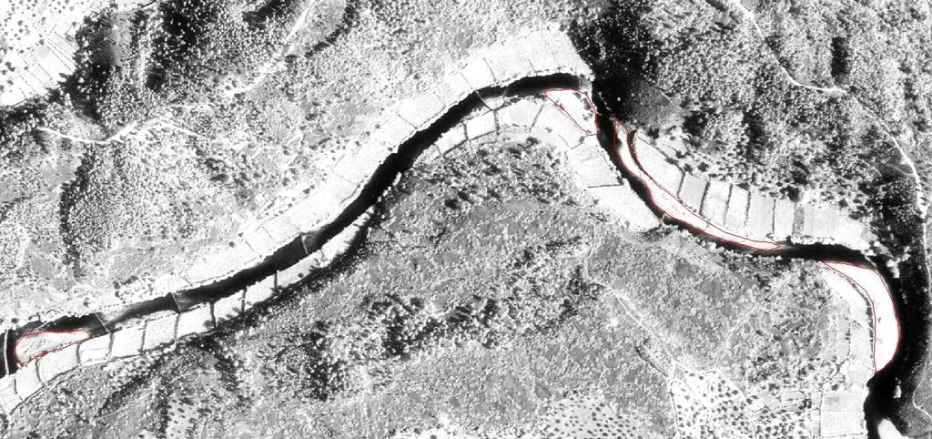
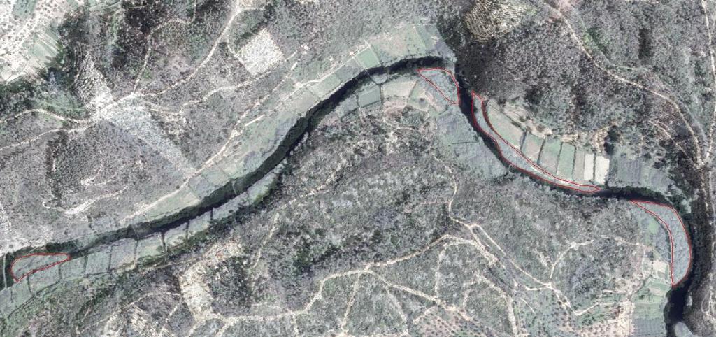
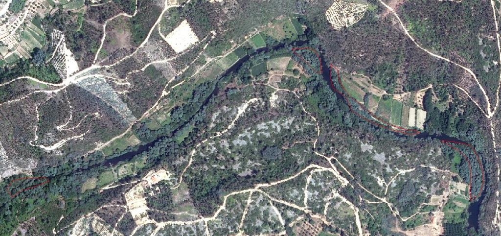
8 Methods 1. Delimitation of riparian patches Touvedo_08Old Touvedo_08New Sampling Units of 250 m long river stretches downstream dams Touvedo N= 77, Fronhas N= 88, Vilarinho das Furnas N= 94

9 Methods 1. Delimitation of riparian patches Riverbank_Tree Bank_Other Bank_Tree Riverbank_ Tree Island_Other Classes Tree - trees and tall shrubs Other - herbaceous vegetation, bare soil River locations Riverbank -riparian zone Banks-inside the channel, connection with riverbanks Islands-inside the channel, no connection with riverbank
 Mean Patch Size (MPS) Patch Size Coefficient of Variation (PSCov) Area, size and")
10 Methods 2. Landscape metrics CATEGORY Landscape metrics Riparian strutural attributes AREA/ DENSITY Weighted Class Area (WCA) Mean Patch Size (MPS) Patch Size Coefficient of Variation (PSCov) Area, size and structural heterogeneity SHAPE/ EDGE Area Weighted Mean Patch Fractal Dimension (AWMPFD) Edge Density (ED) Spatial complexity and lateral connectivity Patch Analyst (vector format) for ArcGIS 10.1
 Land use classes: Scrubland Forest")

11 Methods 3. Delimitation of land-use patches (both river margins; 200 m buffer) Land use classes: Scrubland Forest Agriculture Impervious Unmanaged Managed intensive extensive scrublands, fallow ground with shrubs semi-natural or planted woodlands, usually mixed forests with deciduous quercus Eucalyptus and pine forests crops, orchards, rice fields pastures, recent abandoned lands urban and industrial areas, includes mines, roads
 Test for differences between post (New) and pre (Old) dam periods, for riparian landscape metrics and for percentages of land-uses Paired t-test -")
12 Methods 4. Statistical analysis Hypothesis test (t-test) Test for differences between post (New) and pre (Old) dam periods, for riparian landscape metrics and for percentages of land-uses Paired t-test - Landscape metrics (MPS, WCA, ED) - Percentages of land- uses Independent t-test - Landscape metrics (AWMPFD, PSCov) (inability to match sampling units absence is not a 0 value) Matrix of spatial overlapping between sampling units Corrects the spatial offset between historical and current imagery (river morphology + georeferencing )
13 Results Riparian vegetation changes H1: Riparian woody vegetation show different patterns (area, shape size and complexity) after the dam construction, in all river locations, (riverbank, bank, islands) and for all case studies, although with different magnitudes.
14 MPS: NEW-OLD WCA: NEW-OLD Total area occupied by riparian woodlands increased (WCA) and riparian patches are larger (MPS) in the pos-dam period.
15 AWMPFD Reduced shape complexity (AWMPFD) in the pos-dam period
 Floristic composition change?")

16 Major changes: Vilarinho das Furnas Total riparian area Shape complexity Vilarinho das Furnas case study Low shape complexity Riparian degradation (Fernandes et al., 2011) Floristic composition change?????? Fernandes MR, Aguiar FC, Ferreira MT Assessing riparian vegetation structure and the influence of land use using landscape metrics and geostatistical tools. Landscape and Urban Planning 99(2):
17 Results Riparian vegetation changes H2: Diverse types of dams (storage dams and run-ofriver dams) induce different patterns of vegetation changes
18 MPS: NEW-OLD Significant differences P < 0,001 run-ofriver dam storage dams No significant differences The influence of the dam operation type was only observed in the riparian vegetation located inside the channel

19 Riverbanks - Banks and islands - Touvedo: Run-of-river

20 Riverbanks - Banks and islands - Touvedo: Run-of-river

21 Riverbanks - Banks and islands - Touvedo: Run-of-river
22 Riverbanks - Banks and islands - Fronhas: Storage dam
23 Riverbanks - Banks and islands - Fronhas: Storage dam

24 Fronhas: Storage dam Riverbanks Banks and islands -
25 Results Land use changes Relevant decrease in the agriculture intensive and increase of the impervious area
26
27 Work still continues. Hypothesis 3: Assessing the combined effect of hydrological/land-use effects in the riparian vegetation changes.
28 Acknowledgements Project OASIS (PTDC/AAC-AMB/ ): How to Run Regulated Rivers in semi-arid Regions? Centro de Estudos Florestais - PEst-OE/AGR/UI0239/2014 João Paulo Medeiros Centre of Oceanography, FCUL
Are Dams Regulating Diversity of Riparian Forests?
 Are Dams Regulating Diversity of Riparian Forests? Functional trade-offs and synergies in Mediterranean Europe* Francisca C. Aguiar, Maria João Martins, Maria Dolores Bejarano, ChristerNilsson, Maria Manuela
Open Linked Data in Portugal
 Open Linked Data in Portugal Contribution for INSPIRE Implementation Maria José Vale, Rui Reis, Bruno M. Meneses, Raquel Saraiva, Paulo Patrício, Jesus Estrada Maria José Vale, Rui Reis, Bruno M. Meneses,
Scientific Report to COST. Action ES1104
 Scientific Report to COST Action ES1104 Training School 4 Indicators of Desertification: early warning signs 19 23 May 2014 Faculty of Sciences University of Lisbon, Portugal Organized by Cristina Branquinho
Production and Conservation Trade-off (PaCT) assessment tool
 assessment tool") Production and Conservation Trade-off (PaCT) assessment tool Seeking to better understand the trade-offs associated with different forms of management practices on ecological and economic outcomes Spatial
Production and Conservation Trade-off (PaCT) assessment tool Seeking to better understand the trade-offs associated with different forms of management practices on ecological and economic outcomes Spatial
Quantifying Impacts of Land-use and Land Cover Change in a Changing Climate at the Regional Scale using an Integrated Earth System Modeling Approach
 Quantifying Impacts of Land-use and Land Cover Change in a Changing Climate at the Regional Scale using an Integrated Earth System Modeling Approach Maoyi Huang 1, Guoyong Leng 1, Yannick Le Page 1,2,
A Bird s Eye View of Habitat. Putting the pieces together
 A Bird s Eye View of Habitat Putting the pieces together Restoration Ecology Using what science has learned about living things and their interactions with their environment to re-create habitats that
Quantification of Forest Cover Change in the Pawcatuck River Watershed: A Multi-Method Analysis
 Quantification of Forest Cover Change in the Pawcatuck River Watershed: A Multi-Method Analysis Rebecca Trueman December 2013 NRS533 Class Project Introduction: The detailed study of landscape pattern
LCLU practicals. Mário Caetano. September 5th, 2007 Practicals D3PA
 LCLU practicals Mário Caetano September 5th, 007 Practicals DPA Exercise Sep. 5, 007 DPA LCLU Practicals Mário Caetano Code 4 5 6 7 8 9 0 Class name Urban / Bare soil Sparse vegetation Cropland Other natural
Country fact sheet. Land cover Denmark. September Photo: Toni García, My City/EEA
 Country fact sheet Land cover 2012 Denmark September 2017 Photo: Toni García, My City/EEA Land cover 2012 Overview of land cover & change The overall land cover change rate in Denmark, which has been below
Linear Manmade Structures, Hydroscape Fragmentation, And Ecological Consequences
 Linear Manmade Structures, Hydroscape Fragmentation, And Ecological Consequences Quan Dong US Army Corps of Engineers Hydroscape (Dong 2009) Surface water dominates: patches and flux Spatially heterogeneity:
Kittitas County Voluntary Stewardship Plan
 Kittitas County Voluntary Stewardship Plan Presented by John Small and Nora Schlenker, Anchor QEA 1 Agenda Welcome and Follow-up from Last Meeting Protection and Enhancement Strategies Goals and Measurable
Country fact sheet. Land cover Serbia. September Photo: Toni García, My City/EEA
 Country fact sheet Land cover 2012 September 2017 Photo: Toni García, My City/EEA Land cover 2012 Overview of land cover & change The development of the n landscape seems to remain stable compared to previous
Mission. Selected Accomplishments from Walnut Gulch. Facilities. To develop knowledge and technology to conserve water and soil in semi-arid lands
 USDA-ARS Southwest Watershed Research Center Mission Sound Science for Watershed Decisions To develop knowledge and technology to conserve water and soil in semi-arid lands ARS Watershed Locations Selected
Country fact sheet. Land cover Romania. September Photo: Toni García, My City/EEA
 Country fact sheet Land cover 2012 Romania September 2017 Photo: Toni García, My City/EEA Land cover 2012 Overview of land cover & change The Romanian landscape is characterised by its low dynamics of
Assessment of biodiverse grassland: Comments to ISCC Guidance Document Supplementing ISCC EU 202
 slide 1 of 20 Assessment of biodiverse grassland: Comments to ISCC Guidance Document Supplementing ISCC EU 202 Ecologist M. Sc. Elson Fernandes de Lima Casa da Floresta Assessoria Ambiental Ltda. 8th ISCC
Country fact sheet. Land cover Cyprus. September Photo: Toni García, My City/EEA
 Country fact sheet Land cover 2012 Cyprus September 2017 Photo: Toni García, My City/EEA Land cover 2012 Overview of land cover & change In the period, there has been observed significant decrease of intensity
1.2. Net change in land cover [ha] 12000
![1.2. Net change in land cover [ha] 12000](/thumbs/72/66539401.jpg "1.2. Net change in land cover [ha] 12000") Land cover 2006 Overview of land cover & change The change of landscape in Cyprus during is dominated by formation of artificial and forested land and on the other hand consumption of open spaces/bare
Land cover 2006 Overview of land cover & change The change of landscape in Cyprus during is dominated by formation of artificial and forested land and on the other hand consumption of open spaces/bare
TOWARDS ESTIMATING EMISSIONS FROM GM AND CM IN THE UK
 TOWARDS ESTIMATING EMISSIONS FROM GM AND CM IN THE UK Defra project SP1113 CEH, SRUC, ADAS, AFBI, Ricardo-AEA, University of Aberdeen OBJECTIVES To assess the feasibility of including changes in soil carbon
Country fact sheet. Land cover Switzerland. September Photo: Toni García, My City/EEA
 Country fact sheet Land cover 2012 Switzerland September 2017 Photo: Toni García, My City/EEA Land cover 2012 Overview of land cover & change In the long term, the Swiss landscape shows very low intensity
Country fact sheet. Land cover Luxembourg. September Photo: Toni García, My City/EEA
 Country fact sheet Land cover 2012 Luxembourg September 2017 Photo: Toni García, My City/EEA Land cover 2012 Overview of land cover & change The small country of Luxembourg shows significant decrease of
OVER THE RIPARIAN VEGETATION DYNAMICS IN A. A. García-Arias, F. Francés Instituto de Ingeniería del Agua y Medio Ambiente
 CLIMATE CHANGE SCENARIOS EFFECTS ANALYSES OVER THE RIPARIAN VEGETATION DYNAMICS IN A MEDITERRANEAN REACH (MIJARES RIVER, SPAIN) A. García-Arias, F. Francés Instituto de Ingeniería del Agua y Medio Ambiente
CESAM Centre for Environmental and Marine Studies & DAO Department of Environment and Planning, Universidade de Aveiro, Portugal.
 Impacts of climate and land use changes on the water quality of a vineyard-dominated Mediterranean catchment D. Serpa 1, J.P. Nunes 1, 2, J. Rocha 1, J.J. Keizer 1, N. Abrantes 1 1 CESAM Centre for Environmental
Translation of the CORINE Land Cover nomenclature to the Land Cover Meta Language using LCCS3
 Translation of the CORINE Land Cover nomenclature to the Land Cover Meta Language using LCCS3 Vasco Nunes Remote Sensing Group (GDR) Portuguese Geographic Institute (IGP) http://www.igeo.pt/gdr/ Coordinator:
Hydroecological tool: enhancements and results. enhancements and results. Marci Meixler. Project partners: Sponsored by:
 Hydroecological tool: Marci Meixler Sponsored by: Project partners: Motivation Great Lakes Charter Annex establish uniform, regional protections for Great Lakes waters ensure that authority over the Lake
Country fact sheet. Land cover Portugal. September Photo: Toni García, My City/EEA
 Country fact sheet Land cover 2012 Portugal September 2017 Photo: Toni García, My City/EEA Land cover 2012 Overview of land cover & change In the long term, Portugal is a country with the highest dynamics
Production of the Missouri Land Cover Data Layer Brief Notes 1/00 DRAFT
 Production of the Missouri Land Cover Data Layer Brief Notes 1/00 DRAFT This land cover data layer was derived from Thematic Mapper (TM) satellite data from 1991, 1992, and 1993 (listed below). For most
1.2. Net change in land cover [ha]
![1.2. Net change in land cover [ha]](/thumbs/72/67518217.jpg "1.2. Net change in land cover [ha]") Land cover 2006 Overview of land cover & change After the large political and economical changes in Slovakia during 90 s, the period is characterised by stabilization - rapid decrease of overall intensity
Land cover 2006 Overview of land cover & change After the large political and economical changes in Slovakia during 90 s, the period is characterised by stabilization - rapid decrease of overall intensity
Use of CORINE Land Cover in delivering the EEA strategy
 Use of CORINE Land Cover in delivering the EEA strategy Prof. Jacqueline McGlade Executive Director EIONET Member Countries national teams / co-funding Commission Services: Acknowledgements JRC: joint
The former Yugoslav Republic of Macedonia
 Country fact sheet Land cover 2012 The former Yugoslav Republic of Macedonia September 2017 Photo: Toni García, My City/EEA Land cover 2012 Overview of land cover & change The period in the former Yugoslav
Land Use/Cover Change Different Spatial Level Study: Cognitive and Practical Value. Elena V. Milanova Moscow State University, Russia
 Land Use/Cover Change Different Spatial Level Study: Cognitive and Practical Value Elena V. Milanova Moscow State University, Russia IGU LUCC Conference Prague, Czech Republic, June 28- July 1,2010 The
Country fact sheet. Land cover Liechtenstein. September Photo: Toni García, My City/EEA
 Country fact sheet Land cover 2012 Liechtenstein September 2017 Photo: Toni García, My City/EEA Land cover 2012 Overview of land cover & change As in previous periods, the land cover development in the
Country fact sheet. Land cover Bulgaria. September Photo: Toni García, My City/EEA
 Country fact sheet Land cover 2012 Bulgaria September 2017 Photo: Toni García, My City/EEA Land cover 2012 Overview of land cover & change The overall change rate in Bulgaria is very low, compared to other
Country fact sheet. Land cover Italy. September Photo: Toni García, My City/EEA
 Country fact sheet Land cover 2012 Italy September 2017 Photo: Toni García, My City/EEA Land cover 2012 Overview of land cover & change Italy is a country with a relatively stable landscape, compared to
Overview of land cover & change
 Note The results presented here are based on a change analysis of 44 land cover types mapped consistently on a 1:1. scale across Europe over the decade 199-2 - see Corine land cover programme for details.
Southern Finland regional analysis
 Southern Finland regional analysis Background for the exercise Training example and data created originally for training of regional council of Southern Finland 2013 Aims at presenting a realitic, yet
Country fact sheet. Land cover Hungary. September Photo: Toni García, My City/EEA
 Country fact sheet Land cover 2012 Hungary September 2017 Photo: Toni García, My City/EEA Land cover 2012 Overview of land cover & change With a mean annual land cover change rate of 0.5%, the overall
Country fact sheet. Land cover Slovakia. September Photo: Toni García, My City/EEA
 Country fact sheet Land cover 2012 Slovakia September 2017 Photo: Toni García, My City/EEA Land cover 2012 Overview of land cover & change With the overall land cover change rate of 0.3 of total area,
Agriculture and Climate Change Rural Urban Linkages. Erick Fernandes, Adviser, Agriculture & Rural Development
 Agriculture and Climate Change Rural Urban Linkages Erick Fernandes, Adviser, Agriculture & Rural Development 75% of the world s poor are rural and most are involved in farming In the 21st century, agriculture
DRAFT FOR CONSIDERATION AT THE APRIL 27, 2006 MEETING OF NATURAL RESOURCES COMMITTEE OF THE HIGHLANDS COUNCIL
 RMP Component: Resource Assessment / Ecosystem Assessment Technical Report: Forest Integrity Council Committee: Natural Resource Committee Memorandum Title: Technical Approach to Define Highlands Forest
Bosnia and Herzegovina
 Country fact sheet Land cover 2012 Bosnia and Herzegovina September 2017 Photo: Toni García, My City/EEA Land cover 2012 Overview of land cover & change The overall pace of land cover development in Bosnia
East Baton Rouge Parish Micro-Watershed Characterization
 26 th Annual Louisiana Remote Sensing and GIS Workshop José E. Villalobos-Enciso Warren L. Kron, Jr. April 28, 2010 Presentation Outline Objectives Warren Kron Data Warren Kron Concept José Villalobos
Country fact sheet. Land cover Finland. September Photo: Toni García, My City/EEA
 Country fact sheet Land cover 2012 Finland September 2017 Photo: Toni García, My City/EEA Land cover 2012 Overview of land cover & change The land cover development in Finland has similar intensity and
Center for Urban Rural Interface Studies. Pearl River County, Mississippi Land Cover Analysis
 Center for Urban Rural Interface Studies Pearl River County, Mississippi Land Cover Analysis Introduction The Center for Urban Rural Interface Studies (CURIS) created land cover maps for its focus area
Understanding Washington, DC s Urban Forest through GIS Holli Howard, Casey Trees May, 2007
 Understanding Washington, DC s Urban Forest through GIS Holli Howard, Casey Trees May, 2007 With a mission to restore, enhance and protect the tree canopy of Washington, DC, Casey Trees has a set of ambitious
Country fact sheet. Land cover Malta. September Photo: Toni García, My City/EEA
 Country fact sheet Land cover 2012 Malta September 2017 Photo: Toni García, My City/EEA Land cover 2012 Overview of land cover & change Concerning the land cover development, there occurs no significant
Country fact sheet. Land cover Austria. September Photo: Toni García, My City/EEA
 Country fact sheet Land cover 2012 Austria September 2017 Photo: Toni García, My City/EEA Land cover 2012 Overview of land cover & change 2006-2012 Despite its significant acceleration, compared to the
Initial Stakeholder Meeting Report Intercropping of Walnut Trees in Greece
 Initial Stakeholder Meeting Report Intercropping of Walnut Trees in Greece Work-package 3: Agroforestry for high value trees Specific group: Intercropping of walnut trees with arable crops in Greece Date
Emissions Inventory from Forest Wildfires and Agricultural Activities in Northeastern Mexico during Spring and Summer of 2000
 Emissions Inventory from Forest Wildfires and Agricultural Activities in Northeastern Mexico during Spring and Summer of 2000 Alberto Mendoza Department of Chemical Engineering, Instituto Tecnologico y
Country fact sheet. Land cover Norway. September Photo: Toni García, My City/EEA
 Country fact sheet Land cover 2012 Norway September 2017 Photo: Toni García, My City/EEA Land cover 2012 Overview of land cover & change The Norwegian landscape is characterized by very low intensity of
Country fact sheet. Land cover Slovenia. September Photo: Toni García, My City/EEA
 Country fact sheet Land cover 2012 Slovenia September 2017 Photo: Toni García, My City/EEA Land cover 2012 Overview of land cover & change 2006-2012 In the long term, Slovenia is a country with one of
1.2. Net change in land cover [ha] 15
![1.2. Net change in land cover [ha] 15](/thumbs/88/115381486.jpg "1.2. Net change in land cover [ha] 15") Land cover 2006 Overview of land cover & change The Irish landscape (dominated by pastures and peatlands) shows to be less dynamic during this period as average yearly land cover change rate decreased
Land cover 2006 Overview of land cover & change The Irish landscape (dominated by pastures and peatlands) shows to be less dynamic during this period as average yearly land cover change rate decreased
Annex. Suggestion for EC GIG
 Annex Category Introduction REFCOND-Guidance High status or reference conditions is a state in the present or in the past corresponding to very low pressure, without the effects of major industrialisation,
Restoration of Degraded Mediterranean Rangelands
 7 th SER European Conference on Ecological Restoration 23 27 August, Avignon, France Restoration of Degraded Mediterranean Rangelands Vasilios P. Papanastasis Aristotle University of Thessaloniki, Greece
Climate Change and the Eastern Mediterranean Precipitation Regime
 Climate Change and the Eastern Mediterranean Precipitation Regime Manfred A. Lange Energy, Environment and Water Research Center, The Cyprus Institute EWACC2010 Energy, Water & Climate Change in the Mediterranean
Supplementary material. Assessing the effect of a fuel break network to reduce burnt area and wildfire risk transmission
 International Journal of Wildland Fire 25(6), 619 632 doi: 10.1071/WF15146_AC IAWF 2016 Supplementary material Assessing the effect of a fuel break network to reduce burnt area and wildfire risk transmission
Country fact sheet. Land cover Albania. September Photo: Toni García, My City/EEA
 Country fact sheet Land cover 2012 Albania September 2017 Photo: Toni García, My City/EEA Land cover 2012 Overview of land cover & change With an annual land cover change rate of 0.1, the overall pace
Analysis of changes in land use in the St. Catherines-Niagara area,
 Analysis of changes in land use in the St. Catherines-Niagara area, 1966-1976 De Wet van Niekerk Student #10724078 dewert@gmail.com GEOB 479: Research in GIScience Professor Brian Klinkenberg University
Modeling Cottonwood Habitat and Forecasting Landscape Changes along the Missouri River
 Modeling Cottonwood Habitat and Forecasting Landscape Changes along the Missouri River Lisa Rabbe USACE, Alaska District Kelly A. Burks-Copes US Army Engineer Research and Development Center (ERDC-EL)
Country fact sheet. Land cover Sweden. September Photo: Toni García, My City/EEA
 Country fact sheet Land cover 2012 Sweden September 2017 Photo: Toni García, My City/EEA Land cover 2012 Overview of land cover & change Landscape development in Sweden is very intensive in the 2006-2012
1.2. Net change in land cover [ha] 5000
![1.2. Net change in land cover [ha] 5000](/thumbs/94/120614901.jpg "1.2. Net change in land cover [ha] 5000") Land cover 2006 Overview of land cover & change consists of two regions with significantly different character of the landscape. Lowland region of Vojvodina, situated in the northern part of the country,
Land cover 2006 Overview of land cover & change consists of two regions with significantly different character of the landscape. Lowland region of Vojvodina, situated in the northern part of the country,
Tools to inform delivery of net gain in Natural Capital. Cranfield University, 30 October 2017 Alison Smith
 Tools to inform delivery of net gain in Natural Capital Cranfield University, 30 October 2017 Alison Smith Natural capital Pollination, pest predators Provisioning services Food: crops, livestock, fish
ANNEX III. Executable Test Suite (ETS)
") DS/CDP/2015/07-REV1 part D LPIS Quality Assurance Framework Based on JRC IES/H04/P/PMI/pmi D(2011)(13520) history: this doc started as annex to JRC IPSC/G03/P/WDE/wde D(2009)(10581) ANNEX III Executable
DS/CDP/2015/07-REV1 part D LPIS Quality Assurance Framework Based on JRC IES/H04/P/PMI/pmi D(2011)(13520) history: this doc started as annex to JRC IPSC/G03/P/WDE/wde D(2009)(10581) ANNEX III Executable
Second Wednesdays 1:00 2:15 pm ET
 Second Wednesdays 1:00 2:15 pm ET www.fs.fed.us/research/urban-webinars This meeting is being recorded. If you do not wish to be recorded, please disconnect now. USDA is an equal opportunity provider and
Native Prairie and Parkland Conservation in Alberta: Initiatives by the Alberta Prairie Conservation Forum
 Native Prairie and Parkland Conservation in Alberta: Initiatives by the Alberta Prairie Conservation Forum Maintaining Large Native Prairie and Parkland Landscapes Maintaining Large Native Prairie and
Country fact sheet. Land cover Germany. September Photo: Toni García, My City/EEA
 Country fact sheet Land cover 2012 Germany September 2017 Photo: Toni García, My City/EEA Land cover 2012 Overview of land cover & change Characterized by the annual land cover change rate of 0,1, the
How Much Habitat Is Enough? How Much Disturbance is Too Much?
 How Much Habitat Is Enough? How Much Disturbance is Too Much? Jocelyn Sherwood Canadian Wildlife Service - Ontario January 27 th, 2017 Page 2 April 19, 2017 Page 3 April 19, 2017 Grasslands Forest Wetlands
USING HYDROSCAPES TO MAXIMIZE THE BENEFITS OF RIPARIAN CORRIDOR RESTORATION FOR MULTIPLE RIVER ECOSYSTEM SERVICES
 REFORM International Conference on River and Stream Restoration Novel Approaches to Assess and Rehabilitate Modified Rivers TEMPLATE FOR EXTENDED SUMMARY USING HYDROSCAPES TO MAXIMIZE THE BENEFITS OF RIPARIAN
How Much Habitat is Enough?
 How Much Habitat is Enough? Canadian Wildlife Service 2017 Third Edition Page 2 April 19, 2017 Grasslands Forest Wetlands Riparian & Watershed Page 3 April 19, 2017 Significant impairment in stream At
Kootenai River Ecosystem Operational Loss Assessment, Protection, Mitigation, and Rehabilitation Project (BPA Project Number
 Kootenai River Ecosystem Operational Loss Assessment, Protection, Mitigation, and Rehabilitation Project (BPA Project Number 22- -) ) Norm Merz and Scott Soults Fish and Wildlife Department Kootenai Tribe
Confluence effects in the Sense River. Eawag - Internship: Christina Riedl
 Confluence effects in the Sense River Eawag - Internship: Christina Riedl Introduction Hydro-morphological mapping of confluence effects at the Sense River Background The Network Dynamics Hypothesis: How
Universidade Federal de Mato Grosso-Instituto de Biociências. CEP Cuiabá, Mato Grosso, Brazil
 The Impact of Flooding on Distribution of Woody Plant Communities in the Pantanal of Poconé, Mato Grosso, Brazil. Nunes da Cunha, C. 1 and Junk, W. J. 2 1 Universidade Federal de Mato Grosso-Instituto
Assessing Variability Among Hydrogeomorphic Riverine Wetland Subclasses
 Assessing Variability Among Hydrogeomorphic Riverine Wetland Subclasses Daniel Dvorett1,3, Joseph Bidwell2, Craig Davis1, and Chris DuBois3 1 Department of Natural Resource Ecology and Management, Oklahoma
Landscape Change in the South Atlantic
 Landscape Change in the South Atlantic Bradley A. Pickens North Carolina Cooperative Fish and Wildlife Research Unit, Department of Applied Ecology, North Carolina State University November 12, 2015 South
Country fact sheet. Land cover Spain. September Photo: Toni García, My City/EEA
 Country fact sheet Land cover 2012 Spain September 2017 Photo: Toni García, My City/EEA Land cover 2012 Overview of land cover & change The overall annual land cover change rate in Spain is 0,2, which
Country fact sheet. Land cover Poland. September Photo: Toni García, My City/EEA
 Country fact sheet Land cover 2012 Poland September 2017 Photo: Toni García, My City/EEA Land cover 2012 Overview of land cover & change The comparison of annual change rates for the last three observing
1.2. Net change in land cover [ha] 1000
![1.2. Net change in land cover [ha] 1000](/thumbs/73/69481075.jpg "1.2. Net change in land cover [ha] 1000") Land cover 2006 Overview of land cover & change The development of landscape in Kosovo is characterized by formation of artificial areas, forested land and, to a lesser extent, arable/crop land and consumption
Land cover 2006 Overview of land cover & change The development of landscape in Kosovo is characterized by formation of artificial areas, forested land and, to a lesser extent, arable/crop land and consumption
Case Tejo/Tajo/Tagus: The Spanish perspective
 Case Tejo/Tajo/Tagus: The Spanish perspective Santiago Beguería-Portugués Sergio M. Vicente-Serrano Pyrenean Institute of Ecology Spanish Council of Scientific Research Campus de Aula Dei, P.O. Box 22,
Water and Watersheds. Data Maps Action
 Water and Watersheds Data Maps Action What is the Wildlife Action Plan? Restore rare wildlife and habitats. Keep common species common. 2015 Revision: Partners in Conservation Science 2015 Revision Data
Country fact sheet. Land cover Turkey. September Photo: Toni García, My City/EEA
 Country fact sheet Land cover 2012 Turkey September 2017 Photo: Toni García, My City/EEA Land cover 2012 Overview of land cover & change The overall pace of land cover development in Turkey has increased,
Country fact sheet. Land cover Kosovo* September Photo: Toni García, My City/EEA. *Under UNSCR 1244/99.
 Country fact sheet Land cover 2012 Kosovo* September 2017 Photo: Toni García, My City/EEA *Under UNSCR 1244/99. Land cover 2012 Overview of land cover & change The overall pace of land cover development
ANNEX III. Executable Test Suite (ETS)
") LPIS Quality Assurance Framework Based on JRC IES/H04/P/PMI/pmi D(2011)(13520) history: this doc started as annex to JRC IPSC/G03/P/WDE/wde D(2009)(10581) ANNEX III Executable Test Suite (ETS) The Concept
LPIS Quality Assurance Framework Based on JRC IES/H04/P/PMI/pmi D(2011)(13520) history: this doc started as annex to JRC IPSC/G03/P/WDE/wde D(2009)(10581) ANNEX III Executable Test Suite (ETS) The Concept
Physically-based Watershed Health, Resilience, and Priority Assessment of the Han River Basin in South Korea
 2016 International SWAT Conference July 27-29, 2016, Beijing, China SESSION A2: ENVIRONMENTAL APPLICATIONS Meeting Room No.2 2016 International SWAT Conference Physically-based Watershed Health, Resilience,
ORDINANCE APPENDIX C RUNOFF COEFFICIENTS AND CURVE NUMBERS
 ORDINANCE APPENDIX C RUNOFF COEFFICIENTS AND CURVE NUMBERS TABLE C-1. RUNOFF CURVE NUMBERS Source: Table 2-2a, Table 2-2b, and Table 2-2c from U. S. Department of Agriculture, Natural Resources Conservation
Lakeshore Habitat Condition in Wisconsin. Katie Hein, Caitlin Carlson, Paul Garrison & Tim Asplund
 Lakeshore Habitat Condition in Wisconsin Katie Hein, Caitlin Carlson, Paul Garrison & Tim Asplund When you look at a lake, what do you see? Limnology focused on the pelagic zone and so did state wide monitoring
Simulations of the Effect of Deforestation on Surface Water Runoff and Flooding in the Swift River Watershed.
 Simulations of the Effect of Deforestation on Surface Water Runoff and Flooding in the Swift River Watershed. INTRODUCTION Background Intense rainfall associated with Tropical Storm/Hurricane Michelle
NRCS Programs and Practices for Riparian Areas in Hawaii
 NRCS Programs and Practices for Riparian Areas in Hawaii NRCS Pacific Islands Area Hawaii - State (State (PIA) Office Honolulu, Oahu) Seven field offices (Kauai, Oahu, Molokai, Maui, Hawaii) Plant Materials
The importance of landscapes
 Restoring Biodiversity and Forest Ecosystem Services in Degraded Tropical Landscapes Dr. John A. Parrotta U.S. Forest Service, Research & Development Washington, DC, USA The importance of landscapes Ecosystems
West Fork White River Watershed Conservation Map Summaries. Prepared for the Beaver Watershed Alliance. By the Watershed Conservation Resource Center
 West Fork White River Watershed Conservation Map Summaries Prepared for the Beaver Watershed Alliance By the Watershed Conservation Resource Center November 2014 The Watershed Conservation Resource Center
Davood Nikkami (PhD)
") Country Report of The IR. Iran 28-30 Jan., 2009, Bangkok, Thailand Workshop on Improving Agricultural Productivity, Water Use Efficiency & Strengthening Rural Livelihoods Davood Nikkami (PhD) Soil Conservation
Country Report of The IR. Iran 28-30 Jan., 2009, Bangkok, Thailand Workshop on Improving Agricultural Productivity, Water Use Efficiency & Strengthening Rural Livelihoods Davood Nikkami (PhD) Soil Conservation
APPENDIX E.3.4 TECHNICAL MEMORANDUM FOR VEGETATION/HABITAT MAPPING
 APPENIX E.3.4 TECHNICAL MEMORANUM FOR VEGETATION/HABITAT MAPPING Public Utility istrict No. 1 of Okanogan APPENIX E.3.4 TECHNICAL MEMORANUM FOR VEGETATION/HABITAT MAPPING Vegetation and habitat mapping
Drivers of changes in Mediterranean extensive livestock systems: a microeconometric analysis of a Corsican area.
 Drivers of changes in Mediterranean extensive livestock systems: a microeconometric analysis of a Corsican area. Delattre L, Gueniot F, Moulery M, Napoleone C, Paoli JC, Santucci PM, INRA Does the CAP
1.6 Influence of Human Activities and Land use Changes on Hydrologic Cycle
 1.6 Influence of Human Activities and Land use Changes on Hydrologic Cycle Watersheds are subjected to many types of changes, major or minor, for various reasons. Some of these are natural changes and
Land & Ecosystem Accounts in Europe. Ronan Uhel & Jean-Louis Weber
 Land & Ecosystem Accounts in Europe Ronan Uhel & Jean-Louis Weber Why accounting for Land? Produce synthetic assessments, keeping track of the geographic differences Analyse the relation between changes
Characteristics of Forest Landscapes Throughout the World
 Characteristics of Forest Landscapes Throughout the World Approaches to interpreting landscapes in a region Basic determinants of landscape pattern Geophysical template Biota disturbances Physical template
WASA Quiz Review. Chapter 2
 WASA Quiz Review Chapter 2 Question#1 What is surface runoff? part of the water cycle that flows over land as surface water instead of being absorbed into groundwater or evaporating Question #2 What are
A hydrologic-hydraulic method to define of ecological flows downstream dams located in South European semi-arid regions
 5th WSEAS Int. Conf. on ENVIRONMENT, ECOSYSTEMS and DEVELOPMENT, Tenerife, Spain, December 4-6, 7 39 A hydrologic-hydraulic method to define of ecological flows downstream dams located in South European
Center for Urban Rural Interface Studies. St. John the Baptist Parish, Louisiana Land Cover Analysis
 Center for Urban Rural Interface Studies St. John the Baptist Parish, Louisiana Land Cover Analysis Introduction The Center for Urban Rural Interface Studies (CURIS) created land cover maps for its focus
Gomez-Balandra., M.A*., P. Saldaña F*., R. Llerandi J**., C. Lecanda T**., M. Mijangos C*., and S. Rodriguez T*.
 Indicators to follow-up hydro impacts and mitigation Gomez-Balandra., M.A*., P. Saldaña F*., R. Llerandi J**., C. Lecanda T**., M. Mijangos C*., and S. Rodriguez T*. *Mexican Institute of Water Technology
1.6 Rainfed areas Areas that have no irrigation whatsoever and are precipitation dependent.
 Croplands Definitions Document 1.0 Background Key to effective mapping is to have a precise and clear definition of what is mapped. It is the first and primary step. For example, irrigated areas are defined
Chapter 4 Population and Land Cover
 Chapter 4 Population and Land Cover Population in the French Broad Basin The population of the entire basin for the year 2000 was estimated at about 427,000, or about 151 people per square mile (Figure