Remotely-Sensed Fire Danger Rating System to Support Forest/Land Fire Management in Indonesia
|
|
|
- Harold Hancock
- 6 years ago
- Views:
Transcription
1 Remotely-Sensed Fire Danger Rating System to Support Forest/Land Fire Management in Indonesia Orbita Roswintiarti Indonesian National Institute of Aeronautics and Space (LAPAN) SE Asia Regional Research Information Network (SEARRIN) Presented at International Workshop on Advances in Operational Weather Systems for Fire Danger Rating Edmonton, Canada, July 2008.
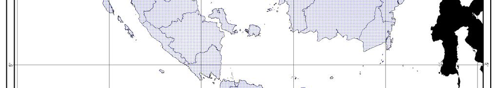
2 Background The number of weather stations in Indonesia are limited. Spatial distribution of these weather stations is not dense. Local scale of FDR information is needed for the local government. The use of satellite remote sensing data is the best alternative. 2
3 WMO Weather Station Distribution Indonesia -- Malaysia -- Philippines -- Thailand -- Laos -- 4 WMO Weather Stations: Brunei Singapore Myanmar Viet Nam
4 FWI System Inputs Required inputs to the FWI system are the: Air temperature Relative humidity 24-hour precipitation 10-m wind speed Previous day s FWI calculation All inputs measured at 12:00 LST (ideally) 4
5 Remote Sensing-based Inputs TXLAPS Qmorph, TRMM DEM NOAA/ AVHRR Wind speed Rainfall Elevation Latitude Land Surface Temperature Air Temperature Land Use: Soil, Vegetation, Water Relative Humidity FWI System Fine Fuel Moisture Content (FFMC) Drought Code (DC) Initial Spread Index (ISI) Fire Weather Index (FWI) TXLAPS: Tropical extended Area Prediction System (BoM, Australia) 00:00 UTC Qmorph: (NOAA) 06:00 UTC to 05:00 UTC TRMM: Tropical Rainfall Measuring Mission (NASA and JAXA) 06:00 UTC to 05:00 UTC DEM: Digital Elevation Model NOAA/AVHRR: National Oceanic and Atmospheric Administration/Advanced Very High Resolution Radiometer (NOAA-16 between 08:00 UTC and 11:00 UTC) e RH = e a s x100% [ * T a ] 5
6 Remote Sensing-based Inputs TXLAPS Qmorph, TRMM Terra/Aqua MODIS Wind speed Rainfall Reflectance Ch1 to Ch7 Tb 31, Tb 32 EVI Water Vapor NDVI Albedo Land Surface Temperature Air Temperature DEM Relative Humidity FWI System Fine Fuel Moisture Content (FFMC) Drought Code (DC) Initial Spread Index (ISI) Fire Weather Index (FWI) MODIS: T b : EVI: NDVI: Moderate Resolution Imaging Spectroradiometer Temperature brightness Enhanced Vegetation Index Normalized Difference Vegetation Index 6
7 Qmorph - NOAA 24-hour Rainfall Spatial coverage: 60.0 N S S (by 8 km and 0.25 ) Temporal coverage: Dec 2002 recent (every 30 minutes) Rainfall estimates are produced from the microwave observation of DMSP-13 (SSMI), DMSP-14 (SSMI), DMSP-15 (SSMI), NOAA-15 (AMSU-B), NOAA-16 (AMSU-B), NOAA-17 (AMSU-B), TRMM (TMI), AQUA (AMSR-E) Tropical Rainfall Measuring Mission (TRMM) NASA and JAXA Spatial coverage: 50.0 N S (by 0.25 ) Temporal coverage: Jan 1998 recent (every 3 hour and monthly) The 3B42RT estimates are produced in four stages; (1) the microwave estimates precipitation are calibrated and combined, (2) infrared precipitation estimates are created using the calibrated microwave precipitation, (3) the microwave and IR estimates are combined, and (4) rescaling to monthly data is applied. 7
8 Qmorph Data 8

9 TRMM 3B42RT Data 9

10 10-m m Wind Speed bin/nmoc/latest_y.pl?idcode=idytx003.10m


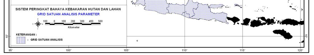
11 Data Grid (2.5 km x 2.5 km) 11
12 FWI Inputs (19 Feb 2008) 12
13 FWI Inputs (19 Feb 2008) 13
")
14 FWI Inputs (19 Feb 2008) 14
15 FWI Inputs (19 Feb 2008) 15
")
16 Fine Fuel Moisture Code (19 Feb 2008) 16
")
17 Fine Fuel Moisture Code (19 Feb 2008) 17
18 Drought Code (19 Feb 2008) 18
19 Drought Code (19 Feb 2008) 19
")
20 Haze Plume (19 Feb 2008) 20
21 Initial Spread Index (19 Feb 2008) 21
22 Fire Weather Index (19 Feb 2008) 22
23 FWI Interpretations (Indonesia and Malaysia) Low Low Class Moderate High Class Moderate High Extreme Extreme Ignition Potential Fine Fuel Moisture Code Interpretation Low probability of fire starts Moderate probability of fire starts in areas of local dryness Grass fuels becoming easily ignitable; high probability of fire starts Grass fuels highly flammable; very high probability of fire starts Difficulty of Control Initial Spread Index Interpretation Low fire intensity in grasslands. Fire will spread slowly or be self-extinguishing. Grassland fires can be successfully controlled using handtools. Moderate fire intensity in grasslands. Handtools will be effective along the fire s flanks, but water under pressure (pumps, hose) may be required to suppress the head fire in grasslands. High fire intensity in grasslands. Direct attack at the fire s head will require water under pressure, and mechanized equipment may be required to build control lines (e.g. bulldozer) Very high fire intensity in grasslands. Fire control will require construction of control lines by mechanized equipment and water under pressure. Indirect attack by back-burning between control lines and the fire may be required. Class Smoke Potential Drought Code Interpretation Low Typical wet-season conditions. More than 30 dry days until DC reaches threshold. Severe haze periods unlikely. Moderate High Extreme Low Class Moderate High Extreme Normal mid dry-season conditions. Between 15 and 30 dry days until DC reaches threshold. Burning should be regulated and monitored as usual. Normal dry-season peak conditions. Between 5 and 15 dry days until DC reaches threshold. All burning in peatlands should be restricted. Weather forecasts and seasonal rainfall assessments should be monitored closely for signs of an extended dry season. Approaching disaster-level drought conditions. Less than 5 dry days until DC reaches threshold, at which point severe haze is highly likely. Complete burning restriction should be enforced. General Fire Danger Fire Weather Index Interpretation Fire will be self-extinguishing. Fires can be easily suppressed with handtools Most fires can be successfully controlled using power pumps and hose Some fires will be difficult to control 23


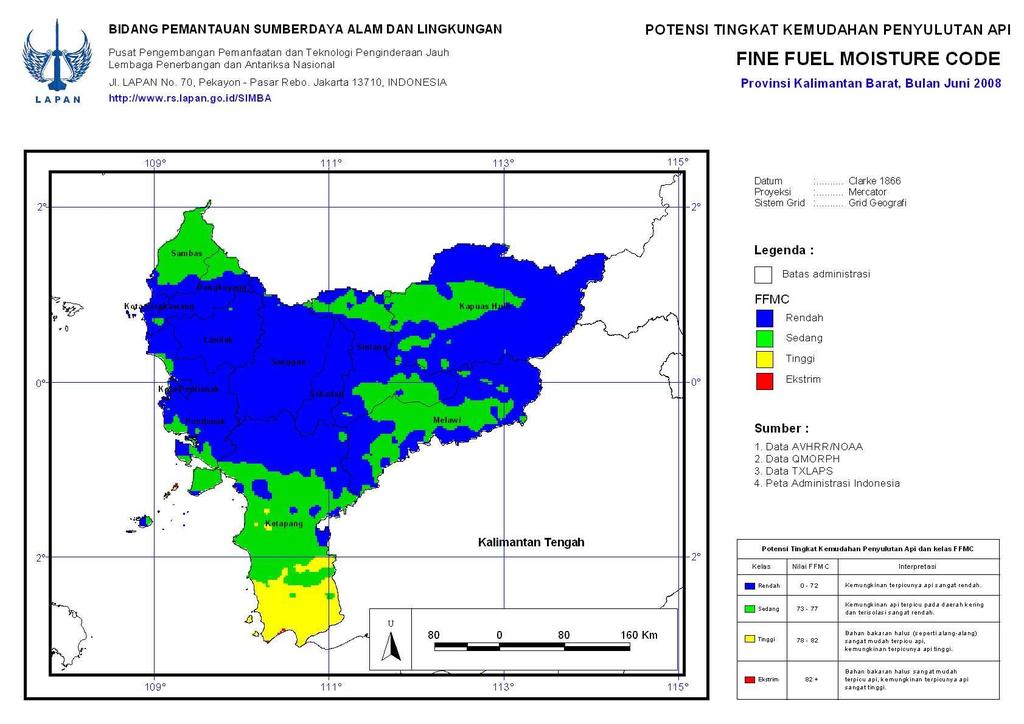
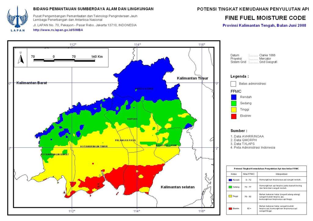
24 Monthly Average of FFMC (Jun 2008) 24


25 LAPAN website:


26 ASEAN Secretariat Haze-on on-line: online.or.id/ 26
27 GOFC-GOLD GOLD website: fire.umd.edu/projects/index.asp 27
28 Concluding Remarks Advantages of using satellite remote sensing data: Provide comprehensive and multi-temporal temporal coverage of large areas in real-time and at frequent intervals. Provide mapping at a regular spatial resolution. Cost-effective. Limitations: Do not directly estimate the meteorological parameters. Data processing is more complex. Clouds block land observation. 28
29 Thank you for your attention 29
Report on Fire Danger Rating System (FDRS)
") Report on Fire Danger Rating System (FDRS) Orbita Roswintiarti, PhD. Indonesian National Institute of Aeronautics and Space (LAPAN) Presented at the Sentinel Asia Joint Project Team Meeting 2010 Manila,
Report on Fire Danger Rating System (FDRS) Orbita Roswintiarti, PhD. Indonesian National Institute of Aeronautics and Space (LAPAN) Presented at the Sentinel Asia Joint Project Team Meeting 2010 Manila,
4.2 SPATIAL DISTRIBUTION OF FIRE SEASON AND ENSO EFFECTS ON THE ISLAND OF SUMATRA, INDONESIA
 4.2 SPATIAL DISTRIBUTION OF FIRE SEASON AND ENSO EFFECTS ON THE ISLAND OF SUMATRA, INDONESIA Robert Field 1, Caren Dymond, William de Groot and Bryan Lee Canadian Forest Service, Edmonton, AB, Canada 1.
ASEAN TECHNICAL WORKSHOP ON DEVELOPMENT OF THE ASEAN PEATLAND FIRE PREDICTION AND EARLY WARNING SYSTEM. Group 1 Report
 ASEAN TECHNICAL WORKSHOP ON DEVELOPMENT OF THE ASEAN PEATLAND FIRE PREDICTION AND EARLY WARNING SYSTEM 20-21 March 2012 Sunway Putra Hotel, Kuala Lumpur, Malaysia Group 1 Report Is there a need for enhancement
Sentinel Asia Wild Fire Control Initiative
 Sentinel Asia Wild Fire Control Initiative JPTM Step2 No.3 July 6-8 Manila Philippine Toshihisa HONMA (Hokkaido Univ.) for Masami FUKUDA (Univ. of Fukuyama) Objective of Sentinel Asia Wildfire Monitoring
th Conf on Hydrology, 85 th AMS Annual Meeting, 9-13 Jan, 2005, San Diego, CA., USA.
 4.12 19th Conf on Hydrology, 85 th AMS Annual Meeting, 9-13 Jan, 5, San Diego, CA., USA. IMPACT OF DEFORESTATION ON THE PROPOSED MESOAMERICAN BIOLOGICAL CORRIDOR IN CENTRAL AMERICA Ronald M Welch 1, Deepak
David Lavoué, Ph.D. Air Quality Research Branch Meteorological Service of Canada Toronto, Ontario
 David Lavoué, Ph.D. Air Quality Research Branch Meteorological Service of Canada Toronto, Ontario National Fire Emissions Technical Workshop New Orleans, LA May 4-6, 2004 Fire regions Canadian Wildfires
FY24 28 JAXA. Big BCG
 RESTEC 26 1 31 2 FY24 28 JAXA 37 3 Big BCG 4 ( + + ) National Spatial Data Infrastructure Theme Maps (1/5,000, 1/10,000,1/25,000, 1/50,000) ( ) GIS ADB GSMaP Input Rain gage Improved Flood prediction model
Wildfire WG. Recent Activities and Agenda. Sentinel Asia Joint Project Team Meeting 2014 Nov 20. Yangon, Myanmar
 Wildfire WG Recent Activities and Agenda Sentinel Asia Joint Project Team Meeting 2014 Nov 20. Yangon, Myanmar Koji Nakau PhD., Hokkaido University Keiji Kimura PhD., Nara University Masami Fukuda PhD.,
National Drought Monitoring in Canada
 National Drought Monitoring in Canada Trevor Hadwen Agriculture and Agri-Food Canada, Agri-Environmental Services Branch (AESB) National Agroclimate Information Service (NAIS) Manitoba, DRI Workshop Winnipeg,
International Workshop on Air Quality in Asia June 24-26, Hanoi. FOREST FIRE INFORMATION SYSTEM (FORIS) (Forest fire early warning method)
 (Forest fire early warning method)") International Workshop on Air Quality in Asia June 24-26, Hanoi FOREST FIRE INFORMATION SYSTEM (FORIS) (Forest fire early warning method) Pham Thanh Tung Duong Le Minh Pham Thanh Tung Nguyen Xuan Thanh
International Workshop on Air Quality in Asia June 24-26, Hanoi FOREST FIRE INFORMATION SYSTEM (FORIS) (Forest fire early warning method) Pham Thanh Tung Duong Le Minh Pham Thanh Tung Nguyen Xuan Thanh
Hydrological Applications of LST Derived from AVHRR
 Hydrological Applications of LST Derived from AVHRR By Balaji Narasimhan Research Assistant Department of Agricultural Engineering Texas A&M University Outline Introduction All about LST Model Development
24 August 2017, PICC, Putrajaya
 24 August 2017, PICC, Putrajaya Nurizana Binti Amir Aziz Meteorological Officer National Climate Center (NCC), Malaysian Meteorological Department (MMD) Ministry of Science, Technology and Innovation(MOSTI)
NERIN-Fire activities (ongoing and future)
") NERIN-Fire activities (ongoing and future) T. Loboda 1, I. Csiszar 1, A. Terekhov 2, D. Ershov 3, E. Loupian 4,O. Ravsal 5 1 University of Maryland, USA; 2 Institute of Space Research, Kazakhstan; 3 Center
NERIN-Fire activities (ongoing and future) T. Loboda 1, I. Csiszar 1, A. Terekhov 2, D. Ershov 3, E. Loupian 4,O. Ravsal 5 1 University of Maryland, USA; 2 Institute of Space Research, Kazakhstan; 3 Center
A new method to estimate rice crop production and outlook using Earth Observation satellite data
 A new method to estimate rice crop production and outlook using Earth Observation satellite data Toshio Okumura, Shin-ich Sobue, Nobuhiro Tomiyama RESTEC Kei Ohyoshi JAXA 17 Feb. 2014 Don Chan Palace,
Municipal Fire Ban on Open Air Burning. Factors for Consideration
 Municipal Fire Ban on Open Air Burning Factors for Consideration May 2008 1 PREFACE The Municipal Fire Ban on Open Air Burning - Factors for Consideration package consists of: 1. Factors for Consideration
UNESCO Pakistan Flood Project Strategic Strengthening of Flood Warning and Management Capacity (Phase 2)
") UNESCO Pakistan Flood Project Strategic Strengthening of Flood Warning and Management Capacity (Phase 2) 7 June 2017 Takanori Miyoshi Satellite Applications and Operation Center (SAOC) Japan Aerospace
UNESCO Pakistan Flood Project Strategic Strengthening of Flood Warning and Management Capacity (Phase 2) 7 June 2017 Takanori Miyoshi Satellite Applications and Operation Center (SAOC) Japan Aerospace
Smart Environment Protection: Disaster Management of Peatland Forest Fire in Brunei
 Smart Environment Protection: Disaster Management of Peatland Forest Fire in Brunei Wida Susanty Haji Suhaili (GL), Somnuk Phon- Amnuaisuk, S.H. Newaz, Thien-Wan Au, Minh-Son Dao, UTB and Ali Selamat,
Hydrologic forecasting for flood risk management Predicting flows and inundation in data-limited catchments
 Hydrologic forecasting for flood risk management Predicting flows and inundation in data-limited catchments Dr. Kelly Kibler Assistant professor Civil, Environmental, & Construction Engineering University
POSSIBILITY OF GCOM-C1 / SGLI FOR CLIMATE CHANGE IMPACTS ANALYZING
 POSSIBILITY OF GCOM-C1 / SGLI FOR CLIMATE CHANGE IMPACTS ANALYZING Y. Honda* a, M. Moriyama b, M. Hori c, M. Murakami c, A. Ono c, K. Kajiwara a a Center for Environmental Remote Sensing (CEReS), Chiba
Evaluation of Indices for an Agricultural Drought Monitoring System in Arid and Semi-Arid Regions
 Evaluation of Indices for an Agricultural Drought Monitoring System in Arid and Semi-Arid Regions Alireza Shahabfar, Josef Eitzinger Institute of Meteorology, University of Natural Resources and Life Sciences
DEVELOPMENT OF A DECISION SUPPORT SYSTEM FOR NATURAL DAMAGE ASSESSMENT BASED ON REMOTE SENSING AND BIO-PHYSICAL MODELS
 DEVELOPMENT OF A DECISION SUPPORT SYSTEM FOR NATURAL DAMAGE ASSESSMENT BASED ON REMOTE SENSING AND BIO-PHYSICAL MODELS M.A. Sharifi a*, W.G.M. Bastiaanssen b, S.J. Zwart b a ITC, P.O. Box 6, 7500 AA, Enschede,
Soil Moisture Validation in the U.S.
 Soil Moisture Validation in the U.S. T. J. Jackson, R. Bindlish, I. Mladenova, and M. Cosh USDA ARS Hydrology and Remote Sensing Lab January 16, 2014 Outline Project Overview GCOM-W AMSR2 Brightness Temperature
Report on an intercomparison study of modelled, Europe-wide forest fire risk for present day conditions
 Contract number GOCE-CT-2003-505539 http://www.ensembles-eu.org RT6/WP6.2 - Linking impact models to probabilistic scenarios of climate Deliverable D6.9 Report on an intercomparison study of modelled,
Remote Sensing of Land & Vegetation. C S Murthy
 Remote Sensing of Land & Vegetation C S Murthy Remote Sensing current status New era of RS in 21 st Century Increased utilisation of data Quantitative algorithms/improved retrieval methods Better calibrations
Remote Sensing of Water Resources
 Remote Sensing of Water Resources National Disaster Management Institute Yoomi Hur Climate Change Hydrologic Cycle Hydrologic Indices Soil Moisture Evaportranspiration Drought Conclusions 3 The water cycle
Emission from Biomass Open Burning in the Mekong River Basin Sub-Region
 Emission from Biomass Open Burning in the Mekong River Basin Sub-Region Savitri Garivait, JGSEE TF HTAP on Emission Inventories and Projections October 18-20, 2006 Hotel Kunlun, Beijing, China 1 Biomass
Fire Occurrence in Borneo s Peatlands Between 1997 and 2005 and it s Impacts
 Workshop on Vulnerability of Carbon Pools of Tropical Peatlands in Asia Pekanbaru, Riau, Sumatra, Indonesia 24-26 January 2006 Fire Occurrence in Borneo s Peatlands Between 1997 and 2005 and it s Impacts
WATER CYCLE VARIABLES
 WATER CYCLE VARIABLES ISSUE: THE PROPOSAL FOR A WORKSHOP FOR THE EVALUATION OF HIGH RESOLUTION GLOBAL PRECIPITATION PRODUCTS HAS NOT RECEIVED FULL FINANCIAL SUPPORT. CONCLUSION: THE ALTERNATIVES PROPOSED
Early detection system of drought in East Asia using NDVI from NOAA/AVHRR data
 INT. J. REMOTE SENSING, 20 AUGUST, 2004, VOL. 25, NO. 16, 3105 3111 Cover Early detection system of drought in East Asia using NDVI from NOAA/AVHRR data X. SONG* Institute of Geographical Sciences & Natural
IOP Conference Series: Earth and Environmental Science. Related content OPEN ACCESS
 IOP Conference Series: Earth and Environmental Science OPEN ACCESS Indonesian drought monitoring from space. A report of SAFE activity: Assessment of drought impact on rice production in Indonesia by satellite
JAXA/Earth Observation Program for Water Resource Management
 JAXA/Earth Observation Program for Water Resource Management Chu Ishida Japan Aerospace Exploration Agency (JAXA) 2 nd Asian Water Cycle Symposium Tokyo January 9-10, 2007 Tropical Rainfall Measuring Mission
Sustainable Management of Peatland Forests in Southeast Asia (SEApeat)
") Sustainable Management of Peatland Forests in Southeast Asia (SEApeat) 2nd REDD+ Project Coordination Meeting 3-4 July 2012 Presentation by Sing Yun Chin, Tong Yiew Chee and Faizal Parish Sustainable Management
Sustainable Management of Peatland Forests in Southeast Asia (SEApeat) 2nd REDD+ Project Coordination Meeting 3-4 July 2012 Presentation by Sing Yun Chin, Tong Yiew Chee and Faizal Parish Sustainable Management
NASA Assets that Support of the Water- Energy-Food Nexus
 NASA Assets that Support of the Water- Energy-Food Nexus Richard Lawford 4 th Regional WEF Nexus Workshop Hilton, Pietermaritzburg, South Africa November 21, 2016 Observation Strategy for the Water Cycle
Crop Monitoring for Food Security from Space
 San Diego, 18-22 February 2010 AAAS Annual Meeting 1 Crop Monitoring for Food Security from Space Felix Rembold Joint Research Centre (JRC) The European Commission s Research-Based Policy Support Organisation
Akiko Suzuki. The Coordination Group for Meteorological Satellites CGMS-45 Plenary 15 June 2017
 The Coordination Group for Meteorological Satellites CGMS-45 Plenary 15 June 2017 Akiko Suzuki Associate Senior Chief Officer of Satellite Applications JAXA Activities Space Transportation Human Space
Research and Applications using Realtime Direct Broadcast Imagery, Weather Radar, and LiDAR in Disaster Response and Preparedness
 Research and Applications using Realtime Direct Broadcast Imagery, Weather Radar, and LiDAR in Disaster Response and Preparedness Richard P. Watson, Ph.D. University of New Mexico Earth Data Analysis Center
Expert Meeting on Crop Monitoring for Improved Food Security, 17 February 2014, Vientiane, Lao PDR. By: Scientific Context
 Satellite Based Crop Monitoring & Estimation System for Food Security Application in Bangladesh Expert Meeting on Crop Monitoring for Improved Food Security, 17 February 2014, Vientiane, Lao PDR By: Bangladesh
Chief, Hydrological Sciences Laboratory NASA Goddard Space Flight Center
 Detection of Extreme Events with GRACE and Data Assimilation, Ph.D. Chief, Hydrological Sciences Laboratory NASA Goddard Space Flight Center Gravity Recovery and Climate Experiment (GRACE) Soil Moisture
Operational products for crop monitoring. Hervé Kerdiles, JRC MARS
 Operational products for crop monitoring Hervé Kerdiles, JRC MARS Outline Meteo products Rainfall, temperature, global radiation, ETa, snow depth Biomass indicators & crop yield prediction NDVI & other
LAND AND WATER - EARTH OBSERVATION INFORMATICS FSP
 Earth Observation for Water Resources Management Arnold Dekker,Juan P Guerschman, Randall Donohue, Tom Van Niel, Luigi Renzullo,, Tim Malthus, Tim McVicar and Albert Van Dijk LAND AND WATER - EARTH OBSERVATION
Major atmospheric emissions from peat fires in SEA during non-drought years: Evidence from the 2013 Sumatran fires David Gaveau
 SOCP/YEL Paul Hilton/SOCP/YEL Reuters Major atmospheric emissions from peat fires in SEA during non-drought years: Evidence from the 2013 Sumatran fires David Gaveau Salim MA, Hergoualc h K, Locatelli
CGIAR Research Program on Water, Land and Ecosystems: Use of remote sensing and GIS tools in the irrigation commands to assist planning and management
 CGIAR Research Program on Water, Land and Ecosystems: Use of remote sensing and GIS tools in the irrigation commands to assist planning and management Summary Remote sensing (RS) and geographic information
WIDE-SCALE MODELLING OF WATER AND WATER AVAILABILITY WITH EARTH OBSERVATION/SATELLITE IMAGERY
 WIDE-SCALE MODELLING OF WATER AND WATER AVAILABILITY WITH EARTH OBSERVATION/SATELLITE IMAGERY Ferreira F 1, Goudriaan R 2, Gibson LA 3, Jarmain C 4, Kemp JN 6, Mashimbye E 5, Münch Z 6, Pauw T 6, Stephenson
Daily maps of fire danger over Mediterranean Europe
 Daily maps of fire danger over Mediterranean Europe Carlos C. DaCamara (1), Teresa J. Calado (1), Sofia L. Ermida (1), Isabel F. Trigo (1,2), Malik Amraoui (1,3) (1) Instituto Dom Luiz, Universidade de
GEO-DRI Drought Monitoring Workshop, May 10-11, 2010, Winnipeg, Manitoba Drought in Southeast Asia
 GEO-DRI Drought Monitoring Workshop, May 10-11, 2010, Winnipeg, Manitoba Drought in Southeast Asia Orn-uma Polpanich Stockholm Environment Institute Asia Bangkok, Thailand Southeast Asia Is located on
Need Additional Information? LEGAL DISCLAIMER ACKNOWLEDGEMENT:
 LEGAL DISCLAIMER This work was implemented as part of the CGIAR Research Program on Climate Change, Agriculture and Food Security (CCAFS) hosted by BISA-CIMMYT in South Asia. The views expressed in this
SCIE 4104E - Environmental Systems Science. Tarendra Lakhankar NOAA-CREST Center, The City University of New York
 SCIE 4104E - Environmental Systems Science Tarendra Lakhankar NOAA-CREST Center, The City University of New York About Class This course focuses on Earth as a system and explores the interdependent relationships
Sea ice concentration alphabet soup: CDRs, ECVs, ESDRs
 Sea ice concentration alphabet soup: CDRs, ECVs, ESDRs Walt Meier, NASA Goddard Polar Space Task Group Fourth Session 30 September 2014 Formal Definition Climate Data Record (CDR) noun, A time series of
January 16-17, 2014 Geneva Switzerland. Presentation by Azhar Ishak Member (RA V) ICT, OPAG2, CAgM, WMO
 ICT, OPAG2, CAgM, WMO") WMO Commission for Agricultural Meteorology (CAgM) Implementation / Coordination Team (ICT) on Support Systems for Agrometeorological Services January 16-17, 2014 Geneva Switzerland Presentation by Azhar
WMO Commission for Agricultural Meteorology (CAgM) Implementation / Coordination Team (ICT) on Support Systems for Agrometeorological Services January 16-17, 2014 Geneva Switzerland Presentation by Azhar
Extending the societal and economic benefits of Earth science research, information, and technology
 NASA WATER SCIENCE & APPLICATIONS NASA S APPLIED SCIENCES PROGRAM Steven Ambrose 1, Jared Entin 2, David Toll 3 and Ted Engman 4 1- Applied Sciences Program, NASA/HQ 2-TerrestrialHydrology Program & NASA
Electricity and Heat. HP Chung UNESCAP Statistics Division. Workshop on Energy Statistics for ASEAN Countries
 Electricity and Heat HP Chung UNESCAP Statistics Division Workshop on Energy Statistics for ASEAN Countries 21-23 November 2017 Kuala Lumpur, Malaysia Overview Main trends Introduction to core concepts
Regional Smoke Haze in Southeast Asia: Causes, Impacts and Possible Solutions
 Regional Smoke Haze in Southeast Asia: Causes, Impacts and Possible Solutions Rajasekhar Bala Division of Environmental Science and Engineering National University of Singapore National Environment Conference
Flood Monitoring WG - Activities Report -
 Flood Monitoring WG - Activities Report - Kazuhiko FUKAMI (ICHARM) & Hiroaki KAI (JAXA) March 13, 2007 3 rd JPT Meeting, Singapore Edited by PWRI with data from CREDO Disaster with death toll of more than
IFAD/GEF Project on Rehabilitation and Sustainable Use of Peatland Forests in Southeast Asia
 IFAD/GEF Project on Rehabilitation and Sustainable Use of Peatland Forests in Southeast Asia 8 th Meeting of Ministerial Steering Committee on Transboundary Haze Pollution 19 August 2009, Singapore Transboundary
APEC s Energy Intensity Reduction Goal: Research Update Ralph D. Samuelson 17 October 2011 Asia Pacific Energy Research Centre (APERC)
") APEC s Energy Intensity Reduction Goal: Research Update Ralph D. Samuelson 17 October 2011 Asia Pacific Energy Research Centre (APERC) Outline What Happened in 2009? Comments on the ERIA Analysis A Look
APEC s Energy Intensity Reduction Goal: Research Update Ralph D. Samuelson 17 October 2011 Asia Pacific Energy Research Centre (APERC) Outline What Happened in 2009? Comments on the ERIA Analysis A Look
GEOGLAM Asia-RiCE Team Activities Update and Accomplishments
 GEOGLAM Asia-RiCE Team Activities Update and Accomplishments Shin-ichi Sobue On behalf of the GEOGLAM Asia-RiCE team 2015/11/16 Regional Cooperation for Rice Crop Monitoring Using Space Technology in Asia
Boini Narsimlu, A.K.Gosain and B.R.Chahar
 Boini Narsimlu, A.K.Gosain and B.R.Chahar The water resource of any river basin is basis for the economic growth and social development. High temporal and spatial variability in rainfall, prolonged dry
Modeling Status Update Review of Data and Documents
 SUSTAINABLE, JUST & PRODUCTIVE WATER RESOURCES DEVELOPMENT IN WESTERN NEPAL UNDER CURRENT & FUTURE CONDITIONS (DIGO JAL BIKAS DJB) Modeling Status Update Review of Data and Documents Tuesday, 1 ST August,
Water use and production in the Central Highlands, Aguascalientes and the Lerma-Chapala watershed
 Water use and production in the Central Highlands, Aguascalientes and the Lerma-Chapala watershed 1. Introduction...1 2. Area description... 1 3. Materials and methods... 2 4. Results and Discussion...
Factors Affecting Gas Species Released in BB. Factors Affecting Gas Species Released in BB. Factors Affecting Gas Species Released in BB
 Factors Affecting Gas Species Trace from Biomass Burning. The Main Variables* The Amount and Type of gas species released from fire are conditioned by: Chemical and Physical features of the Ecosystem *(Alicia
River information management and flood forecasting in Japan
 River information management and flood forecasting in Japan Tomonobu SUGIURA Senior Researcher Hydrologic Engineering Research Team Management (ICHARM) Contents 1. Objectives of river information management
How safe is Beijing s Air Quality for Human Health? Naresh Kumar Θ
 How safe is Beijing s Air Quality for Human Health? Naresh Kumar Θ Abstract: The success of the 2008 Olympics will be largely impacted by the level of air pollution in Beijing. The World Health Organization
MODULE 8 LECTURE NOTES 5 REMOTE SENSING APPLICATIONS IN DROUGHT ASSESSMENT
 MODULE 8 LECTURE NOTES 5 REMOTE SENSING APPLICATIONS IN DROUGHT ASSESSMENT 1. Introduction Drought is a phenomenon of long-term moisture deficiency. It may be meteorological, agricultural or hydrologic
New wildfire terms for 2017
 2017.06.27 New wildfire terms for 2017 INSIDE THIS ISSUE Stages of Control 1 Northwest Update 2 Crew Activities 3 Weather Maps 4 Weather Indices 5 FireSmart 6 Restrictions and Contacts 6 NWFC NUMBERS Since
STATUS OF FOREST FIRE MANAGEMENT AND CONTROL IN VIETNAM
 GEOSS AP Symposium Integrated Observation for Sustainable Development in the Asia-Pacific Region STATUS OF FOREST FIRE MANAGEMENT AND CONTROL IN VIETNAM Dr. Hoang Minh Hien Disaster Management Center Ministry
Remote Sensing Monitoring of Vector-borne Disease
 Remote Sensing Monitoring of Vector-borne Disease Malaria Project ID: 10515 C-PI: Prof. Chuan-rong Li Team members: Hong-bing Niu, Ling-li Tang, Zhao-yan Liu Key Laboratory of Quantitative Remote Sensing
Issues include coverage gaps, delays, measurement continuity and consistency, data format and QC, political restrictions
 Satellite-based Estimates of Groundwater Depletion, Ph.D. Chief, Hydrological Sciences Laboratory NASA Goddard Space Flight Center Greenbelt, MD Groundwater Monitoring Inadequacy of Surface Observations
Drought Indicators for the SADC
 Drought Indicators for the SADC Bruce Eady DHI-SA Annual Conference Coping with Drought: Adaptions to Water Stress in the Face of Climate Change Agenda Introduction Satellite Data Drought and Flood Portal
The Spatial Analysis between SWAT Simulated Soil Moisture, and MODIS LST and NDVI Products
 Konkuk University, Seoul, South Korea The Spatial Analysis between SWAT Simulated Soil Moisture, and MODIS LST and NDVI Products Geun Ae PARK Post-doctoral Researcher, Dept. of Civil and Environmental
ASEAN IVO PROJECT PROGRESS REPORT. NAPC: Networked ASEAN Peat Swamp Forest Communities. 28 Nov 2018, Wednesday Sari Pacific Hotel, Jakarta
 ASEAN IVO PROJECT PROGRESS REPORT NAPC: Networked ASEAN Peat Swamp Forest Communities 28 Nov 2018, Wednesday Sari Pacific Hotel, Jakarta 1 Presentation Outline What is NAPC? Project Objectives Major Issues
South Asia Drought Monitoring System (SADMS) A Collaborative project by IWMI, GWP and WMO under Integrated Drought Management Programme
 A Collaborative project by IWMI, GWP and WMO under Integrated Drought Management Programme") South Asia Drought Monitoring System (SADMS) A Collaborative project by IWMI, GWP and WMO under Integrated Drought Management Programme NDVI 2002 NDVI 2003 Giriraj Amarnath, Niranga Alahacoon, Peejush
South Asia Drought Monitoring System (SADMS) A Collaborative project by IWMI, GWP and WMO under Integrated Drought Management Programme NDVI 2002 NDVI 2003 Giriraj Amarnath, Niranga Alahacoon, Peejush
Keywords : Forest Fire Hazard, Fuel type, GIS, Soil Erosion Hazard, Land and Forest degradation
 Forest Fire Hazard Model Using Remote Sensing and Geographic Information Systems: Toward understanding of Land and Forest Degradation in Lowland areas of East Kalimantan, Indonesia Mulyanto Darmawan Graduate
GEO-DRI Drought Monitoring Workshop, May 10-11, 2010, Winnipeg, Manitoba. Drought in Southeast Asia
 GEO-DRI Drought Monitoring Workshop, May 10-11, 2010, Winnipeg, Manitoba Drought in Southeast Asia Climate change, drought, agriculture and economics was caused by an early end to the monsoon season coupled
HKH-HYCOS regional flood information system and its benefits to SAsiaFFG system
 HKH-HYCOS regional flood information system and its benefits to SAsiaFFG system First Steering Committee Meeting (SCM 1) New Delhi, INDIA 26-28 April 2016 Mandira Singh Shrestha International Centre for
Asia RiCE: Rice Crop Estimation and Monitoring (the role of PALSAR 2)
") ALOS Kyoto & Carbon Initiative 22snd Science Team meeting (KC#22) Asia RiCE: Rice Crop Estimation and Monitoring (the role of PALSAR 2) Toshio Okumura (RESTEC) On behalf of the GEOGLAM Asia RiCE team Feb
ALOS Kyoto & Carbon Initiative 22snd Science Team meeting (KC#22) Asia RiCE: Rice Crop Estimation and Monitoring (the role of PALSAR 2) Toshio Okumura (RESTEC) On behalf of the GEOGLAM Asia RiCE team Feb
GEOGLAM Crop Monitor
 GEOGLAM Crop Monitor No. 28 May 2016 Prepared by members of the GEOGLAM Community of Practice Coordinated by the University of Maryland The Crop Monitor is a part of GEOGLAM, a GEO global initiative. http://www.geoglam-crop-monitor.org/
CEOS Update: JECAM EO Data Access & NASA/JECAM Cloud-Based SDMS
 CEOS Update: JECAM EO Data Access & NASA/JECAM Cloud-Based SDMS Alyssa Whitcraft on behalf of CEOS Ad Hoc WG for GEOGLAM Program Scientist & Component 4 Lead GEOGLAM Secretariat / UMD akwhitcraft@geoglam.org
STUDY ON SOIL MOISTURE BY THERMAL INFRARED DATA
 THERMAL SCIENCE, Year 2013, Vol. 17, No. 5, pp. 1375-1381 1375 STUDY ON SOIL MOISTURE BY THERMAL INFRARED DATA by Jun HE a, Xiao-Hua YANG a*, Shi-Feng HUANG b, Chong-Li DI a, and Ying MEI a a School of
Towards a European Forest Fire Simulator
 Towards a European Forest Fire Simulator J.M. Baetens Research Unit Knowledge-based Systems Ghent University COST Green Engineering Camp July 2, 2012 KERMIT J.M. Baetens (KERMIT) A European Forest Fire
Assimilation of Satellite Remote Sensing Data into Land Surface Modeling Systems
 Assimilation of Satellite Remote Sensing Data into Land Surface Modeling Systems Ming Pan Dept. of Civil and Environmental Engineering, Princeton University Presented at the Graduate Seminar at Dept. of
Efficient Lighting Potential. Stuart Jeffcott. Expert Consultant to UNEP
 Efficient Lighting Potential Stuart Jeffcott Expert Consultant to UNEP Individual country results forthcoming 2 Detailed Country Lighting Assessments will be published by UNEP in the coming months with
SECRETARIAT OF THE CONVENTION TO COMBAT DESERTIFICATION SECRETARIAT DE LA CONVENTION SUR LA LUTTE CONTRE LA DESERTIFICATION
 in arid, semi-arid and dry sub-humid areas resulting from various factors (Cf. the UNCCD); refers to Long-term loss of ecosystem function and productivity caused by disturbances from which the land cannot
ASSESSMENT DETAILS SIT718 Real World Analytics Assessment Task 3: Problem solving task 2
 ASSESSMENT DETAILS SIT718 Real World Analytics Assessment Task 3: Problem solving task 2 Using aggregation functions for data analysis This document supplies detailed information on assessment tasks for
Use of GIS and Remote Sensing to assess Soil Erosion in Arid to Semiarid Basin in Jordan
 Use of GIS and Remote Sensing to assess Soil Erosion in Arid to Semiarid Basin in Jordan Ibrahim Farhan and Jawad Al Bakri Dept. Land, Water & Env. Faculty of Agriculture, University of Jordan, Amman,
Future Climate and Wildfire. Mike Flannigan University of Alberta and the Canadian Partnership for Wildland Fire Science
 Future Climate and Wildfire Mike Flannigan University of Alberta and the Canadian Partnership for Wildland Fire Science CIF Rocky Mountain Technical Session 22 November 2017 1 Outline Fire in Canada Climate
Investigating the Impact of Climate Change on Flooding in the Sittaung River Basin, Myanmar
 Investigating the Impact of Climate Change on Flooding in the Sittaung River Basin, Myanmar Su Su Kyi * MEE1673 Supervisor: Assoc. Prof. Mohamed Rasmy** Prof. Toshihiro Koike** Dr. Duminda Perera** ABSTRACT
GEO FCT activities in INDONESIA Progress and Plans
 GEO FCT activities in INDONESIA Progress and Plans KUSTIYO Indonesian National Institute of Aeronautics and Space (LAPAN) MRV Joint Workshop 22-24 June 2010, Guadalajara, Jalisco Mexico Table of contents
DIRECTORATE GENERAL OF CLIMATE CHANGE THE MINISTRY OF ENVIRONMENT AND FORESTRY
 HOW LAND AND FOREST FIRES SHOULD FIT INTO FOREST REFERENCE EMISSION LEVEL (FREL) DIRECTORATE GENERAL OF CLIMATE CHANGE THE MINISTRY OF ENVIRONMENT AND FORESTRY HOW LAND AND FOREST FIRES SHOULD FIT INTO
ABCC Program: Status and Progress
 ABCC Program: Status and Progress Huadong Guo ABCC Program Team September 23, 2010 Ottawa, Canada Outline Global Change Challenge Why ABCC? Research Framework Current Progress Future Perspective 1. Global
6. DATA AND INFORMATION TECHNOLOGY
 6. DATA AND INFORMATION TECHNOLOGY Lead authors: J.G. Masek and V. N. Razuvaev Contributing authors: V. Gershenzon and P. Ya. Groisman 6.1. NEESPI Data Requirements Observations are an important component
Forest change detection in boreal regions using
 Forest change detection in boreal regions using MODIS data time series Peter Potapov, Matthew C. Hansen Geographic Information Science Center of Excellence, South Dakota State University Data from the
 Fernando Gilbes 1, William Hernández, Natlee Hernández, José Martínez, and Vilmaliz Rodriguez Geological and Environmental Remote Sensing Lab Department of Geology University of Puerto Rico at Mayagüez
Development of South Asia Drought Monitoring System
 Project Report June 2015 Development of South Asia Drought Monitoring System Submitted by International Water Management Institute (IWMI), Colombo, Sri Lanka Grant Supported by: Global Water Partnership
AWRA-L and CABLE modelled Tb using CMEM
 AWRA-L and CABLE modelled Tb using CMEM Luigi Renzullo, Ben Gouweleeuw, Albert van Dijk A water information R & D alliance between the Bureau of Meteorology and CSIRO s Water for a Healthy Country Flagship
Drought monitoring experiences of India
 REGIONAL WORKSHOP ON UNDERSTANDING THE OPERATIONAL ASPECTS OF THE DROUGHT OBSERVATION SYSTEM IN MONGOLIA, 17 Sep 2018 Drought monitoring experiences of India Dr. C.S. Murthy Head, Agricultural Sciences
South Asia Drought Monitoring System (SADMS) A Joint Collaborative project by IWMI, GWP and WMO under Integrated Drought Management Programme
 A Joint Collaborative project by IWMI, GWP and WMO under Integrated Drought Management Programme") South Asia Drought Monitoring System (SADMS) A Joint Collaborative project by IWMI, GWP and WMO under Integrated Drought Management Programme Giriraj Amarnath, Niranga Alahacoon, Peejush Pani, Vladimir
South Asia Drought Monitoring System (SADMS) A Joint Collaborative project by IWMI, GWP and WMO under Integrated Drought Management Programme Giriraj Amarnath, Niranga Alahacoon, Peejush Pani, Vladimir
Fire Research Report. Spatial Prediction of Wildfire Hazard Across New Zealand. Landcare Research. June 2001
 Fire Research Report Spatial Prediction of Wildfire Hazard Across New Zealand June 2001 The objective of this project was to develop high-resolution, spatially explicit data layers describing wildfire
Coupling fire information with climate: General methodology
 Coupling fire information with climate: General methodology Valentina Bacciu, IAFES Sassari valentina.bacciu@cmcc.it 3 rd Workshop on Fire Spread and Behavior Modeling in a context of Climate Change July
Climate Data and Drought Research
 Climate Data and Drought Research Can NLWIS Help the Drought Research Initiative? A. Howard: Agriculture and Agri-Food Canada What is the National Land and Water Information Service? An across-canada,
APPLICATIONS USING THE ATMOSPHERIC DATA OF THE PACE MISSION
 APPLICATIONS USING THE ATMOSPHERIC DATA OF THE PACE MISSION Ali H. Omar (NASA) Maria Tzortziou (CCNY), Woody Turner (NASA) Groups/Subgroups: Atmospheric Correction, Applications, Atmospheric by-products