Riparian Buffer Plantings. Image: Virginia Outdoor Foundation
|
|
|
- Louisa Mason
- 6 years ago
- Views:
Transcription


1 Riparian Buffer Plantings Image: Virginia Outdoor Foundation


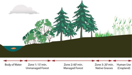
2 A riparian buffer is land next to a river, stream, or creek that is usually vegetated with trees or shrubs, and acts as a protective filter for the river system. Riparian buffers can vary in width, from 500 feet to 50 feet, depending on the adjacent land use. A majority of Pennsylvania s streams are comprised of small streams, also known as headwater streams, which are important areas to reduce nutrients and increase water quality. Trout Creek is a headwater stream, draining to the Schuylkill River Watershed; re-establishing riparian buffers along Trout Creek will have multiple benefits, as described below. Multiflora Rose Much of the Trout Creek streamside is forested, although invasive species such as Multiflora Rose and Milea-Minute Weed threaten the viability and health of what riparian buffer exists. Where the streambank is not forested, turf grass is the vegetation most utilized by homeowners along Trout Creek proper. This BMP discussion is a starting point for the homeowner who seeks to restore the riparian buffer, and should be used along with Native Landscape Restoration BMP so that the proper plant species are chosen. As with all BMPs included in this document, professional guidance could be enlisted to aid the homeowner in design and construction. An important consideration for homeowners in the Trout Creek Watershed is that adjacent land uses will influence the buffer width and vegetation types used to establish a riparian buffer. Though a USDA Forest Service recommended three-zone riparian-forested buffer is ideal, (detailed discussion below), this may not always be feasible to establish especially in residential suburban situations such as Trout Creek neighborhoods. Mile-a-Minute Weed Images: Cahill Associates, Inc.

3 Benefits * * * * * Costs $ $ $ $ $ Benefits Riparian buffers have been well documented to provide a number of economic and environmental values. Buffers are characterized by high species density, high species diversity, and high bio-productivity as a transition between aquatic and upland environments. A Riparian Buffer provides a number of benefits, including: Reduce flooding by slowing down stormwater runoff that travels over the land surfaces into Trout Creek. Reduce non-point source pollution (by trapping pollutants and debris that is carried in runoff.) Increase streambank stability Decrease streambank erosion Improve water quality by enhancing the infiltration of pesticides, nutrients, pathogens, and sediment. Increase wildlife habitat Increased shading lowers water temperature Support a diverse array of wildlife Provide recreation and aesthetics for residents. Cost Considerations Costs for a riparian buffer restoration project are site-specific since every property has different conditions that will relate to the costs.. Installing a riparian buffer involves site preparation, planting design, second year reinforcement planting, and additional maintenance. Establishment and maintenance costs should be considered up front when considering your riparian buffer design. Image: Cahill Associates, Inc.
 utilize the following outline for estimating costs for establishment and")
4 Both the USDA Riparian Handbook and the PADEP/PADCNR Stream ReLeaf Forest Buffer Toolkit (see Additional Resources for more information) utilize the following outline for estimating costs for establishment and maintenance:

5 Ease of Development/Construction The PADEP/PADCNR-advocated summary below is recommended for homeowners during the planning stages of a buffer restoration project. Proper planning will lead to easier construction and budgeting. 1. Obtain Landowner Permission and Support Consider talking with your neighbors to collaborate on a design you may save money if you buy plants in bulk from your local native nursery. In addition, there are grants available for tree plantings for groups of homeowners who organize to plant trees in their neighborhood. 2. Make Sure Site is Suitable for Restoration If streambanks are extensively eroded, consider alternative location. Rapidly eroding streambanks may undermine seedlings. Streambank restoration may need to occur prior to riparian buffer restoration. Obtain professional help or talk with a Township representative to evaluate your needs for streambank restoration. 3. Analyze Site s Physical Conditions The most important physical condition of the site is the soil, which will control plant selection. Evaluate the soil using the online soil mapper provided by USDA ( to determine important soil characteristics such as flooding potential, seasonal high water table, topography, soil ph, soil moisture, etc. Also, include a simple field test with direct observation of soil conditions. Again, you may want to talk to a Township representative to evaluate your needs. Here in Trout Creek, the slope of the buffer is important to consider. Much of the creek is drained by properties whose front and side yards are extremely sloping. This is an important item to note when planning a riparian buffer restoration. Image: United States Department of Agriculture
6 Forests provide as much as 40 times the water storage of a cropped field and 15 times that of grass turf. 4. Analyze Existing Vegetation Existing vegetation present at the restoration site should be examined to determine the strategy for buffer establishment, using the Native Plant List provided in the Additional Resources section: Identify Desirable Species - Native tree and shrub species that thrive in riparian habitats in Pennsylvania should be used. These species should be identified in the restoration site and protected for their seed bank potential. Several native vines and shrubs (blackberry, greenbriar, poison ivy, Virginia creeper, and spicebush) can provide an effective ground cover during establishment of the buffer, though should be selectively controlled for herbaceous competition. Identify Undesirable Species: Consider utilizing undesirable species such as the black locust for their shade function during buffer establishment. Consider controlling invasive plants prior to buffer planting. Identify Sensitive Species: Since riparian zones are rich in wildlife habitat and wetland plant species to be aware of any rare, threatened or endangered plant (or animal) species. Contact the Delaware County Planning Commission for the county s Natural Areas Inventory Plan. 5. Draw a Sketch of the Site Prepare a sketch of the site that denotes important existing features, including stream width, length, streambank condition, adjacent land uses and stream activities, desired width of buffer, discharge pipes, obstructions, etc. This is a critical component of the plan and will help the homeowner budget for plantings. 6. Create a Design that Meets Multiple Objectives Consider landowner objectives: Consider the current use of the buffer by the landowner, especially if the buffer will be protected in perpetuity. Consider linking the buffer to an existing (or planned trail system). Buffer width: Riparian buffer areas do not have a fixed linear boundary, but vary in shape, width, and vegetative type and character. Many factors including slope, soil type, adjacent land uses, floodplain, vegetative type, and watershed condition influence what can be planted. The most commonly approved minimum buffer widths for water quality and habitat maintenance are feet. Buffers less than 35 feet do not protect aquatic resources long term. Consider costs: The planting design (density, type, mix, etc.) will ultimately be based on the financial constraints of the project. Consider phasing your plantings over 2 or 3 seasons in order to help defray direct costs. Choose the appropriate plants: This manual encourages the use of native plants in stormwater management facilities. Since they are best suited to our local climate, native species have distinct
7 genetic advantages over non-native species. Ultimately using native plants translates into greater survivorship with less replacement and maintenance a cost benefit to the landowner. Please refer to the plant list in Additional Resources for a comprehensive list of native trees and shrubs available for stormwater management facility planting. Choose the plant size: Plants can be purchased as seeds, container seedling, bare-root seedlings, plugs, or nursery stock. Ultimately, financial resources will guide the decision since larger plant material will generally cost more. On the other hand, larger plants will generally establish more rapidly. 7. Draw a Planting Plan Some rules of thumb for tree spacing and density based on plant size at installation: Seedlings 6-10 feet spacing Bare Root Stock feet spacing Larger & Container feet spacing The formula for Estimating Number of Trees and Shrubs is as follows: # Plants = length x width of corridor (ft) / 50 square feet This formula assumes each tree will occupy an average of 50 sq. ft., random placement of plants approximately 10 feet apart, and mortality rate of up to 40% that can be absorbed by the growing forest system. Once a homeowner has a planting density and mix, drawing the planting plan is fairly straightforward. The plan can vary from a highly technical (drawn to scale) plan, or a simple line drawing of the site. All plans must show the site with areas denoted for trees and shrub species, along with notes for plant spacing and buffer width. 8. Prepare Site Ahead of Time Existing site conditions will determine the degree of preparation needed prior to planting. Invasive infestation and vegetative competition are extremely variable, and therefore must be considered in the planning stages. Site preparation should begin in the fall prior to planting. Enlist professional to determine whether use of chemical controls are necessary to prepare site for planting. Release desired existing saplings from competition by undesired species with either herbicide application (consult a professional) or physical removal. If utilizing a highly designed planting layout, mark site ahead of time with flags, spray paint, or other markers so that the appropriate plant is put in the right place.


8 9. Determine Maintenance Needs An effective buffer restoration project should include management and maintenance guidelines, as well as an awareness of allowable and unallowable uses in the buffer. Weed control is essential for the survival and rapid growth of trees and shrubs, and can include any of the following: Organic mulch, preferably leaf-compost, leaf litter Weed control fabrics Shallow cultivation Pre-emergent herbicides Mowing Non-chemical weed control methods are preferred since chemicals can easily enter the water system. Aesthetics * * * * * Aesthetics As with any landscaping effort, beauty is in the eye of the beholder. There are multiple examples of homes with existing riparian buffers in the Trout Creek Watershed which suggests a very attractive result. Initial phases of Restoration may be less than ideal aesthetically, as trees take time to mature and develop a reasonable canopy; special shorter-term woodland floor perennial species can be planted to improve aesthetics as the trees are maturing. Proper maintenance will serve to preserve aesthetics and keep the area being restored from appearing unkempt.
9 Township Review No Township review is necessary for a homeowner to undertake this BMP. The Township should be informed of the Riparian Buffer Restoration plan so that Township staff are aware of special maintenance practices being imposed and its intentional nature. In establishing a new riparian forest buffer, it is usually both economical and practical to select a group of no more than 6 to 12 species. Zone 1 is located along the streambank and provides detritus and shade to the stream. This zone is likely to be flooded and should therefore be dominated by flood tolerant hardwood species. Hardy shrub species, such as dogwoods and willows, can also be planted along the streambank to provide stabilization. Zone 2 contains a managed forest and may include hardwoods and conifers that have more intermediate flood tolerances. Zone 3, if needed, may contain grasses or other features helpful in slowing and infiltrating water. Shrubs and small trees may also be desirable in Zone 3 to provide a diversity of habitats for birds and wildlife. Site Constraints Most properties adjacent to Trout Creek can undertake this Riparian Buffer restoration BMP. The stream often flows through a front yard with a road way providing a delimiting boundary. Adjacent land uses need to be considered in the initial planning phase of this project, as certain land uses create a constraint for proper riparian buffer establishment. Variations Much research has been done on the benefits of riparian buffers, primarily by the USDA. Based on this research, the USDA recommends the following Design Criteria for proper riparian forested buffer establishment and function. A Riparian Buffer consists of three distinct zones, as shown in the previous image (page 2) and below. Zone 1: Zone 1 will begin at the top of the streambank and occupy a strip of land with a fixed width of 15-feet measured horizontally on a line perpendicular to the streambank. The purpose of Zone 1 is to create a stable ecosystem adjacent to the water s edge, provide soil/water contact area to facilitate nutrient buffering processes, provide shade to moderate and stabilize water temperature encouraging the production of beneficial algal forms, and to contribute necessary detritus and large woody debris to the stream ecosystem. Dominant vegetation will be composed of a variety of native riparian tree and shrub species and such plantings as necessary for streambank stabilization during the establishment period. A mix of species will provide the prolonged stable leaf fall and variety of leaves necessary to meet the energy and pupation needs of aquatic insects. Large overmature trees are valued for their detritus and large woody debris. Zone 1 will be limited to bank stabilization and removal of potential problem vegetation. Occasional removal of extreme high value trees may be permitted where water quality values are not compromised. Logging and other overland equipment shall be excluded except for stream crossings and stabilization work. Zone 2: Zone 2 will begin at the edge of Zone 1 and occupy an additional strip of land with a minimum width of 60-feet measured horizontally on a line perpendicular to the streambank. Total minimum width of Zones 1 & 2 is therefore 75 feet.

10 Image: United States Department of Agriculture; D.J.Welsch The purpose of Zone 2 is to provide necessary contact time and carbon energy source for buffering processes to take place, and to provide for long term sequestering of nutrients in the form of forest trees. Outflow from subsurface drains must not be allowed to pass through the riparian forest in pipe or tile, thus circumventing the treatment processes. Subsurface drain outflow must be converted to sheet flow for treatment by the riparian forest buffer, or treated elsewhere in the system prior to entering the surface water. Predominant vegetation will be composed of riparian trees and shrubs suitable to the site, with emphasis on native species, and such plantings as necessary to stabilize soil during the establishment period. 10
11 Zone 3: Zone 3 will begin at the outer edge of Zone 2 and have a minimum width of 20-feet. Additional width may be desirable to accommodate land-shaping and mowing machinery. Grazed or ungrazed grassland meeting the purpose and requirements stated below may serve as Zone 3. The purpose of Zone 3 is to provide sediment filtering, nutrient uptake, and the space necessary to convert concentrated flow to uniform, shallow, sheet flow through the use of techniques such as grading and shaping, and devices such as diversions, basins, and level lip spreaders. Vegetation will be composed of dense grasses and forbs for structure stabilization, sediment control, and nutrient uptake. Mowing and removal of clippings are necessary to recycle sequestered nutrients, promote vigorous sod, and control weed growth. Vegetation must be maintained in a vigorous condition. The vegetative growth must be hayed, grazed, or otherwise removed from Zone 3. Maintaining vigorous growth of Zone 3 vegetation must take precedence and may not be consistent with wildlife needs. Vegetation Selection by Zone Zone 1 & 2 vegetation will consist of native streamside and upland tree species as identified on the following image. Deciduous species are important to be used in Zone 2 due to the production of carbon leachate from leaf litter which drives bacterial processes that remove nitrogen, as well as the sequestering of nutrients in the growth processes. In our climate, the use of evergreens is also important due to the potential for nutrient uptake during the winter months. In all riparian buffer planting projects, a variety of species is important to meet the habitat needs of insects important to the aquatic food chain. Zone 3 vegetation should consist of perennial grasses and forbs. Appendix 7 of the Chesapeake Bay Riparian Handbook provides detailed summary information on choosing native plants for riparian buffers. Please consult the Resources section of this guide for more information, as well as your local native nursery. 11


12 Make sure to plant appropriate species in each zone so that you maximize survival rates. Check out the Resources found in this CD Guide for more detailed information. 12
13 Maintenance The riparian buffer is subject to many threats, including herbivory, invasion by exotic species, competition for nutrients by adjacent herbaceous vegetation, and human disturbance. Proper maintenance is important to ensure the long-term effectiveness and sustainability of a restored riparian buffer. The most critical period during buffer establishment is maintenance of the newly planted trees during canopy closure, typically the first 3 to 5 years. Ongoing maintenance practices are necessary for both small seedlings and larger plant materials. Maintenance and monitoring plans should be prepared for the specific site and caretakers need to be advised of required duties during the regular maintenance period. Maintenance d d d d Maintenance measures that should be performed regularly: 1. Watering Plantings need deep regular watering during the first growing season, either natural watering via rainfall, or planned watering, via caretaker. Planting in the fall increases the likelihood of sufficient rain during planting establishment. 2. Mulching Mulch will assist in moisture retention in the root zone of plantings, moderate soil temperature, provide some weed suppression, and retard evaporation Use coarse, organic mulch that is slow to decompose in order minimize repeat application Apply 2-4 inch layer, leaving air space around tree trunk to prevent fungus growth. Use combination of woodchips, leaves, and twigs that are stockpiled for six months to a year. 3. Weed control Weed competition limits buffer growth and survival, therefore weeds should be controlled by either herbicides, mowing, or weed mats: Herbicides: This is a short-term maintenance technique (2-3 years) that is generally considered less expensive and more flexible than mowing, and will result in a quicker establishment of the buffer. Herbicide use is regulated by the PA Department of Agriculture. Proper care should be taken to ensure that proximity to water features is considered. Mowing: Mowing controls the height of the existing grasses, yet increases nutrient uptake, therefore competition for nutrients will persist until the canopy closure shades out lower layers. A planting layout similar to a grid format will facilitate ease of mowing yet yield an unnaturally spaced community. Mowing may result in strikes on the trunk unless protective measures are utilized. Mowing should occur twice each growing season. Mower height should be set between 8 12 inches. Weed Mats: Weed mats are geo-textile fabrics that are used to suppress weed growth around newly planted vegetation by providing shade and preventing seed deposition. Weed mats are installed after planting, and should be removed once the trees have developed a canopy that will naturally shade out weeds. 13
 2) homemade deer repellents 3) tree shelters. Invasive Plants: Monitor the restoration site regularly for any signs of invasive plants.")
14 Deer Considerations: Deer will browse all vegetation within reach, generally between 5-6 feet above the ground. Approaches to minimize damage include: 1) selecting plants that deer do not prefer (ex. Paper Birch, Beech, Ash, Common Elderberry) 2) homemade deer repellents 3) tree shelters. Invasive Plants: Monitor the restoration site regularly for any signs of invasive plants. Consult the list of common invasive plants found in Additional Resources. Special Maintenance Considerations: Riparian buffer restoration sites should be monitored to maximize wildlife habitat and water quality benefits, and to discover emerging threats to the project. During the first four years, the new buffer should be monitored four times annually (February, May, August, and November are recommended) and inspected after any severe storm. Repairs should be made as soon as possible. Survival rates of up to 70% area deemed to be successful. Calculate percent survival by the following equation: (# of live plants / # of installed plants) * 100 = Percent Survival 14
BMP 5.4.2: Protect /Conserve/Enhance Riparian Areas
 BMP 5.4.2: Protect /Conserve/Enhance Riparian Areas The Executive Council of the Chesapeake Bay Program defines a Riparian Forest Buffer as "an area of trees, usually accompanied by shrubs and other vegetation,
Maintaining Riparian Areas and Wetlands
 Maintaining Riparian Areas and Wetlands Riparian areas are the lands along the banks of our rivers, lakes, and tidal waters. Many riparian areas not only border surface waters, but they are often adjacent
Appendix E : Guidelines for Riparian Buffer Areas
 Appendix E : Guidelines for Riparian Buffer Areas This document should be read in conjunction with the CRCA Planning Policy. 1.0 PURPOSE The purpose of this document is to summarize the recommendations
Vegetative Buffer Regulations to Protect Water quality
 Vegetative Buffer Regulations to Protect Water quality Robert Jontos, PWS, CPESC Land-Tech Consultants, Inc. Environmental Scientists and Engineers Connecticut Association of Conservation and Inland Wetland
3/8/2015. What You Will Learn: Intermediate Use Areas: Considerations and Tools. Time line for Forestry Activities
 Intermediate Use Areas: Considerations and Tools The Woods In Your Backyard Program What You Will Learn: Options for converting lawns and intermediate use areas to natural areas. Tools and equipment considerations
Logan River at Rendezvous Park, Channel and Floodplain Restoration: Crack Willow (Salix fragilis) Issues and Management Strategies
 Issues and Management Strategies") Logan River at Rendezvous Park, Channel and Floodplain Restoration: Crack Willow (Salix fragilis) Issues and Management Strategies Prepared May 2, 2017 by Darren Olsen, BIO-WEST, Inc. Issues Crack willow
Logan River at Rendezvous Park, Channel and Floodplain Restoration: Crack Willow (Salix fragilis) Issues and Management Strategies Prepared May 2, 2017 by Darren Olsen, BIO-WEST, Inc. Issues Crack willow
Chapter 5: Water Quality Buffer Requirements
 Chapter 5: Water Quality Buffer Requirements 5.1 Introduction Water quality buffer requirements apply to all new land development or redevelopment containing streams or other water bodies such as ponds,
VIDEO: Riparian Forest Buffers: The Link Between Land & Water
 VIDEO: Riparian Forest Buffers: The Link Between Land & Water Introduction to Riparian Buffers Adapted from: Riparian Forest Buffers: The Link Between Land & Water. Maryland Cooperative Extension. Wye
SECTION 10: WETLANDS PROTECTION
 SECTION 10: WETLANDS PROTECTION 10-1 INTENT AND PURPOSE A. Intent 1. The City finds that wetlands serve a variety of beneficial functions. Wetlands maintain water quality, reduce flooding and erosion,
The Importance of Riparian Forests
 The Importance of Riparian Forests By Jean Llewellyn Monroe County is the second fastest growing county in Pennsylvania. This rapid growth can be problematic because uncontrolled and unregulated growth
Don t Mow. Let it Grow!
 Don t Mow. Let it Grow! The Science Behind the Need for Riparian Buffer Protection. Chelsea Walker, WCD Watershed Specialist chelsea@wcdpa.com 724-837-5271 What is a Riparian Buffer? A riparian buffer
TOWN OF SMYRNA Water Quality Buffer Zone Policy
 TOWN OF SMYRNA Water Quality Buffer Zone Policy Section I - Description A water quality buffer zone (a.k.a. a riparian zone) is a strip of undisturbed native (indigenous) vegetation, either original or
15A NCAC 02B.0238 NEUSE RIVER BASIN-NUTRIENT SENSITIVE WATERS MANAGEMENT STRATEGY: AGRICULTURAL NITROGEN REDUCTION STRATEGY The following
 15A NCAC 02B.0238 NEUSE RIVER BASIN-NUTRIENT SENSITIVE WATERS MANAGEMENT STRATEGY: AGRICULTURAL NITROGEN REDUCTION STRATEGY The following requirements apply to all persons in the Neuse River Basin who
CHAPTER 1. Ecological Integrity
 CHAPTER 1 Ecological Integrity RIPARIAN RESTORATION ECOLOGICAL INTEGRITY This chapter suggests a broad interpretation of the riparian ecosystem and its influences. Often riparian ecosystems are described
Water Resource Protection. Today s Presentation
 Water Resource Protection Article X Ordinance Revision February 14, 2007 Today s Presentation Buffer Definitions Buffer Functions\Benefits Buffer Ordinance Purpose Overview of the Local, and State buffer
Charles T. Young, Presented at: NCER Conference August 1, 2011 Baltimore, MD
 Case Study: Riparian Habitat Restoration for Improved Water Quality and Habitat in Highly Developed Suburban Watershed West Whiteland Township Park, Exton, PA Charles T. Young, Barry Dubinski, Stacie Popp-Young
Adams County, Pennsylvania
 Adams County, Pennsylvania Riparian Forest Buffer Protection A Guide for Municipal Officials & Citizens of Adams County August 2011 Riparian Forest Buffer Protection A Guide for Municipal Officials &
Conservation Practices for Water Quality: Sediment & Nutrient Control. Trap Sediments/Trap Nutrients on the Field. Improve Soil Health.
 Conservation Practices for Water Quality: Sediment & Nutrient Control. Trap Sediments/Trap Nutrients on the Field. Improve Soil Health. Sediment Conservation Cover Cover Crop Critical Area Planting Field
Riparian Buffers for Water Resource Protection
 Riparian Buffers for Water Resource Protection Michael R. Burchell II Associate Professor and Extension Specialist Department of Biological and Agricultural Engineering Riparian Areas From Latin ripa -
2017 Agricultural Water Quality Workshop
 2017 Agricultural Water Quality Workshop Focus Area Lower Lewis and Clark Clatsop SWCD has identified this area as one that needs much improvement This does not mean we can t do projects in other areas
Agricultural/Rural Riparian Buffer Analysis
 Agricultural/Rural Riparian Buffer Analysis December 2014 Executive Summary The Agricultural/Rural Riparian Buffer Analysis was developed from a 2014 analysis of current requirements for the riparian areas
Site Condition Evaluation & Environmental Benefits Report
 Site Evaluation & Environmental Benefits Report Background The New York State Conservation Reserve Enhancement Program is a collaborative effort between the USDA and the State of New York. The goal of
4. Ponds and infiltration BMPs can achieve 60 to 100% removal efficiencies for sediment.
 Landscape BMPs For the purposes of this project, preventive measures have been categorized into two categories: landscape BMPs and source prevention BMPs. Landscape BMPs includes both vegetative practices
ELK RAPIDS TOWNSHIP WATER QUALITY ACTION PLAN
 ELK RAPIDS TOWNSHIP WATER QUALITY ACTION PLAN Elk-River-Chain-of-Lakes Gaps Analysis Project The Watershed Center Grand Traverse Bay Tip of the Mitt Watershed Council Michigan Department of Natural Resources
Riparian Buffer Requirements. Department of Environmental Protection Bureau of Watershed Management
 102.14 - Riparian Buffer Requirements Department of Environmental Protection Bureau of Watershed Management 102.2 Scope and Purpose BMPs to protect, maintain, and restore water quality and existing designated
Stream Corridor Protection and Adaptive Management Manual. Prepared for the City of Independence, Missouri
 Stream Corridor Protection and Adaptive Management Manual Prepared for the City of Independence, Missouri Rock Creek Independence, Missouri By Patti Banks Associates and Applied Ecological Services, Inc.
LITTLE SHADES CREEK RESTORATION PROJECT CWA Section 319(h) Nonpoint Source Implementation Grant Project Workplan #17 ADEM Contract #C
 Nonpoint Source Implementation Grant Project Workplan #17 ADEM Contract #C") LITTLE SHADES CREEK RESTORATION PROJECT CWA Section 319(h) Nonpoint Source Implementation Grant Project Workplan #17 ADEM Contract #C90593066 PARTNERS Alabama Department of Environmental Management Cawaco
LITTLE SHADES CREEK RESTORATION PROJECT CWA Section 319(h) Nonpoint Source Implementation Grant Project Workplan #17 ADEM Contract #C90593066 PARTNERS Alabama Department of Environmental Management Cawaco
CITY OF SPRING HILL Water Quality Buffer Zone Policy (Adopted April 22, 2008)
") Section I - Description CITY OF SPRING HILL Water Quality Buffer Zone Policy (Adopted April 22, 2008) A water quality buffer zone (a.k.a. a riparian zone) is a strip of undisturbed native (indigenous)
Section I - Description CITY OF SPRING HILL Water Quality Buffer Zone Policy (Adopted April 22, 2008) A water quality buffer zone (a.k.a. a riparian zone) is a strip of undisturbed native (indigenous)
Fire Management CONTENTS. The Benefits of Guidelines...3 Considerations...4
 Fire Management CONTENTS Fire Management 1 Introduction...3 The Benefits of Guidelines...3 Considerations...4 Planning...5 Burn Plan Development...5 Operational Activities...8 Pre-Ignition Activities...8
Grand Traverse Bay Watershed Protection Plan:
 Grand Traverse Bay Watershed Protection Plan: An Overview Sarah U Ren Program Director The Watershed Center 231-935-1514, suren@gtbay.org The Grand Traverse Bay Watershed 973 square miles Bay Volume =
Lesson 2-2: Riparian Zones
 2-14 Lesson 2-2: Riparian Zones Time of Lesson: 1 hour Rationale: The purpose of this lesson is to define what a riparian zone is and link its importance for fish and other animals, and humans, and the
Chapter 13: Wildlife and Vegetation
 Chapter 13: Wildlife and Vegetation Introduction and Setting Nevada County contains an extremely wide range of plants, animals and habitat types. With topographic elevations ranging from 300 feet in the
Maintaining & Enhancing Soil Health
 Maintaining & Enhancing Soil Health 5 Forest Operations Manual The Conservation Forestry Program Maintaining & Enhancing Soil Health 5 C H A P T E R 3. 1 Fo re s t Ba n k Ph i l o s o p h y 5. 1 T he Na
Mechanical Site Preparation
 Mechanical Site Preparation 1 Mechanical Site Preparation Introduction...3 CONTENTS The Benefits of Guidelines...3 Considerations...5 Design Outcomes To Maintain Soil Productivity...6 Planning...7 Planning
WQ-08 ENHANCED DRY SWALE
 Greenville County Technical Specification for: WQ-08 ENHANCED DRY SWALE 1.0 Enhanced Dry Swale 1.1 Description An Enhanced Dry Swale is a shallow open-channel drainage way stabilized with turf grass or
THE WATERSHED The watershed is an area of land that drains into a stream. This includes both the surface runoff and groundwater. Because a stream is m
 Understanding Streams A stream is the product of its watershed. Good land use in the watershed will be reflected in the stream. MOST PEOPLE enjoy the captivating qualities of flowing water. But streams
RIPARIAN FOREST BUFFER
 RIPARIAN FOREST BUFFER (Acres) Code 391 Natural Resources Conservation Service Conservation Practice Standard I. Definition An area predominantly of trees and shrubs that functions as a vegetated ecotone
The Science Behind Forest Riparian Protection in the Pacific Northwest States By George Ice, Summer 2004
 The Science Behind Forest Riparian Protection in the Pacific Northwest States By George Ice, Summer 2004 Riparian buffers, streamside management zones, and similar measures are essential parts of forest
POLICY FOR NATURAL RESOURCE MANAGEMENT AREAS
 POLICY FOR NATURAL RESOURCE MANAGEMENT AREAS I. POLICY STATEMENT Auburn University's (the University's) "Policy for Natural Resource Management Areas" implements the Campus Master Plan Land Use Element
Riparian Buffers and Stream Restoration
 Riparian Buffers and Stream Restoration Why focus on riparian areas? Link land and water on any given site and link landscapes together in a watershed Riparian corridors protect the circulatory system
orking Trees for Water Quality
 W Agroforestry orking Trees for Water Quality Working Trees: a partner in watershed management. Agroforestry helps to protect water quality while achieving both landowner and community objectives. Water
The Value of Buffers For Pesticide Stewardship and Much More
 The Value of Buffers For Pesticide Stewardship and Much More Always read and follow label directions before buying or using a pesticide. Follow all appropriate federal, provincial, and local regulations.
NRCS Programs and Practices for Riparian Areas in Hawaii
 NRCS Programs and Practices for Riparian Areas in Hawaii NRCS Pacific Islands Area Hawaii - State (State (PIA) Office Honolulu, Oahu) Seven field offices (Kauai, Oahu, Molokai, Maui, Hawaii) Plant Materials
Phase III Watershed Implementation Plans
 Phase III Watershed Implementation Plans Including programmatic outcomes in your planning to provide co-benefits for your community and reduce pollution Rachel Felver Chesapeake Bay Program Director of
Reservoir age, increasing human population,
 B-6249 02/12 Eagle Mountain Watershed Management Brent Clayton, Justin Mechell, David Waidler and Clint Wolfe* Reservoir age, increasing human population, and changing land uses have prompted the development
Roots for Rivers. An Introduction to Floodplain Restoration & Steps For Implementing A Reforestation Project In Your Watershed
 Roots for Rivers An Introduction to Floodplain Restoration & Steps For Implementing A Reforestation Project In Your Watershed Kimber Ray Resource Service Coordinator The Watershed Institute 609-737-3735
Implementation of Act 162 of 2014 Riparian Buffer or Riparian Forest Buffer Offsetting
 Implementation of Act 162 of 2014 Riparian Buffer or Riparian Forest Buffer Offsetting March 11, 2015 Dial-in number for Audio: 1-877-668-4493 Access code: 642 373 389 WebEx Technical Support: 866-229-3239
Natural and Engineered Wetlands for Stormwater Management
 Natural and Engineered Wetlands for Stormwater Management Dan Hitchcock, Ph.D., P. E. Baruch Institute of Coastal Ecology and Forest Science Clemson University Georgetown, SC Prominence and Diversity of
4.22 Site Reforestation / Revegetation
 4.22 Site Reforestation / Revegetation Best Management Practice Description Site reforestation/revegetation refers to the process of planting trees, shrubs and other native vegetation in disturbed pervious
Streamside Management. How the area around your pond effects the water.
 Streamside Management Zones and Water Quality How the area around your pond effects the water. Stream(pond)side Management Zone A streamside management zone (SMZ) is a strip of land immediately adjacent
Riparian Vegetation Protections. Heritage Tree Protection
 PLACER Protections in place: Oak Tree Retention/ Replacement Requirements General Plan Language Specific Voluntary Rural Design require preservation of native trees and groves through replacement and dedication
BANKS TOWNSHIP WATER QUALITY ACTION PLAN
 BANKS TOWNSHIP WATER QUALITY ACTION PLAN Elk-River-Chain-of-Lakes Gaps Analysis Project The Watershed Center Grand Traverse Bay Tip of the Mitt Watershed Council Michigan Department of Natural Resources
BLOCKING AND FILLING SURFACE DRAINAGE DITCHES
 MINNESOTA WETLAND RESTORATION GUIDE BLOCKING AND FILLING SURFACE DRAINAGE DITCHES TECHNICAL GUIDANCE DOCUMENT Document No.: WRG 4A-1 Publication Date: 10/14/2015 Table of Contents Introduction Application
APPENDIX A. KEY RIPARIAN FUNCTIONS, SUPPORTING VEGETATIVE CONDITIONS, AND RIPARIAN BUFFER DESIGN CONSIDERATIONS
 APPENDIX A. KEY RIPARIAN FUNCTIONS, SUPPORTING VEGETATIVE CONDITIONS, AND RIPARIAN BUFFER DESIGN CONSIDERATIONS Riparian functions Provide shade to keep water cool. Stabilize stream bank to prevent erosion.
ALABAMA S BEST MANAGEMENT PRACTICES. Protection of Water Quality During Timber Harvesting
 ALABAMA S BEST MANAGEMENT PRACTICES Protection of Water Quality During Timber Harvesting Water Quality Responsibility Landowners and/or involved professional forestry practitioners such as: Forest resource
Background. AEM Tier 2 Worksheet Stream & Floodplain Management. Glossary
 AEM Tier 2 Worksheet Stream & Floodplain Management Glossary Bankfull Stage: The stage at which water starts to flow over the flood plain; the elevation of the water surface at bankfull discharge. (This
Role of Soils in Water Quality. Mike Marshall Extension Associate Texas A&M-Institute of Renewable Natural Resources
 Role of Soils in Water Quality Mike Marshall Extension Associate Texas A&M-Institute of Renewable Natural Resources Water Quality in Texas Water is a finite resource that can be impaired by pollution from
FACTSHEET: Grow Agriculturally Productive Buffers
 FACTSHEET: Grow Agriculturally Productive Buffers Every river needs a riparian buffer: a section of forest and vegetation along a river s banks helps control floods, stabilize riverbanks, maintain water
Mill Creek Restoration in Lower Merion Township. PH (610) ; FAX (610) ;
 ; FAX (610) ;") Mill Creek Restoration in Lower Merion Township Vincent L. Sortman 1 and Robert M. Lambert 2 1 Biohabitats, Inc., 15 W. Aylesbury Road, Timonium, MD 21093; PH (410) 337-3659; FAX (410) 583-5678; email:
Mill Creek Restoration in Lower Merion Township Vincent L. Sortman 1 and Robert M. Lambert 2 1 Biohabitats, Inc., 15 W. Aylesbury Road, Timonium, MD 21093; PH (410) 337-3659; FAX (410) 583-5678; email:
From the Ground Up- Field Soil Considerations
 From the Ground Up- Field Soil Considerations Ted Bilderback Nursery Extension Specialist Department of Horticulture Science North Carolina State University Ted_Bilderback@ncsu.edu http://www.ces.ncsu.edu/depts/hort/nursery/
2017 MB Envirothon. Theme Training Document
 2017 MB Envirothon Theme Training Document Envirothon Training Soil and Water Conservation Stewardship: Beneficial Management Practices Types of BMPs Water Management BMPs: Water Retention Wetland Restoration
West Fork White River Watershed Conservation Map Summaries. Prepared for the Beaver Watershed Alliance. By the Watershed Conservation Resource Center
 West Fork White River Watershed Conservation Map Summaries Prepared for the Beaver Watershed Alliance By the Watershed Conservation Resource Center November 2014 The Watershed Conservation Resource Center
Restoring Riparian Zone Function
 Restoring Riparian Zone Function What is riparian function? Ecosystem function can be defined as all of the processes necessary to preserve and create goods or services valued by humans. Functioning riparian
Anne Hairston-Strang MD DNR Forest Service September 7, 2017
 Anne Hairston-Strang MD DNR Forest Service September 7, 2017 Improving Forest-related BMPs Riparian Forest Buffers Consider drainage flow context and Farm Plan Address concentrated flows with companion
TYPICAL CONTENTS OF A SITE-SPECIFIC NATURAL RESOURCE AND WOODLAND STAND DELINEATION MAP:
 TYPICAL CONTENTS OF A SITE-SPECIFIC NATURAL RESOURCE AND WOODLAND STAND DELINEATION MAP: A Site Context Map (1"=200') for vicinity within 1000' of the property Scale of map (to match scale of submitted
Title 92 ROADSIDE VEGETATION MANAGEMENT POLICY
 Title 92 Chapters: ROADSIDE VEGETATION MANAGEMENT POLICY Chapter 92.04 - ROADSIDE VEGETATION MANAGEMENT Chapter 92.04 Sections: ROADSIDE VEGETATION MANAGEMENT 92.04.010 ROADSIDE MAINTENANCE. 92.04.020
Maitland Valley WATERSHED
 Maitland Valley WATERSHED Report Card 2018 Maitland Conservation has prepared this report card as a summary of the state of your forests, wetlands, and water resources. WHERE ARE WE? We are one of 36 Conservation
FieldDoc.io User Guide For 2016 NFWF Chesapeake Bay Stewardship Fund Applicants
 FieldDoc.io User Guide For 2016 NFWF Chesapeake Bay Stewardship Fund Applicants This guide provides step-by-step instructions for the use of FieldDoc.io to estimate nutrient and sediment load reductions
4.4.7 Buffers (also known as Riparian Forested Buffers)
") 4.4.6.7 Monitoring and Maintenance Sediment accumulation eventually will render an infiltration device ineffective, so regular inspections are necessary. Because the trenches and dry wells are belowground
4.4.6.7 Monitoring and Maintenance Sediment accumulation eventually will render an infiltration device ineffective, so regular inspections are necessary. Because the trenches and dry wells are belowground
Re: Initial Comments on the Mount Laguna and Pine Valley Community Defense and Healthy Forest Restoration Project
 Marian Kadota Adaptive Management Services Enterprise Team U.S. Forest Service 1072 Casitas Pass Road #288 Carpinteria, CA 93013 mkadota@fs.fed.us Re: Initial Comments on the Mount Laguna and Pine Valley
Appendix A: Vegetation Treatment Descriptions and Unit Specific Design Criteria
 Appendix A: Vegetation Treatment Descriptions and Unit Specific Design Criteria The table below describes the Kabetogama Project proposed vegetation treatments associated with Alternative 2. The treatment
Degradation of the resource Fertility loss Organic matter Tilth degradation. Water quality Sediment Nutrients
 Near Blue River ca. 1980 Degradation of the resource Fertility loss Organic matter Tilth degradation Water quality Sediment Nutrients Program cost Cheaper to prevent Still expensive Long-term productivity
Conservation Practices. Conservation Choices. These five icons will show the benefits each practice offers... 6/4/2014
 Conservation Choices Your guide to conservation and environmental farming practices. Conservation Choices These five icons will show the benefits each practice offers... The practice reduces soil erosion
MANAGEMENT OF WATERFRONT PROPERTIES FOR HOMEOWNERS
 Prince William County Watershed Management MANAGEMENT OF WATERFRONT PROPERTIES FOR HOMEOWNERS Living along the shoreline brings many rewards for the property owner: a great view, a closeness to nature
Center for Nutrient Solutions (CNS) Nutrient Solution Scenarios Concept Paper September 5, 2014 Draft
 Nutrient Solution Scenarios Concept Paper September 5, 2014 Draft") I. Introduction Center for Nutrient Solutions (CNS) Nutrient Solution Scenarios Concept Paper September 5, 2014 Draft A key goal of the CNS is to develop and test tools for evaluating tactics and strategies
I. Introduction Center for Nutrient Solutions (CNS) Nutrient Solution Scenarios Concept Paper September 5, 2014 Draft A key goal of the CNS is to develop and test tools for evaluating tactics and strategies
CLEARWATER TOWNSHIP WATER QUALITY ACTION PLAN
 CLEARWATER TOWNSHIP WATER QUALITY ACTION PLAN Elk-River-Chain-of-Lakes Gaps Analysis Project The Watershed Center Grand Traverse Bay Michigan Department of Environmental Quality July 2011 Purpose The Grand
Riparian Round Up. Adapted from: An original Creek Connections activity. Creek Connections, Allegheny College, Meadville, Pennsylvania, 16335
 Riparian Round Up Adapted from: An original Creek Connections activity. Creek Connections, Allegheny College, Meadville, Pennsylvania, 16335 Riparian Functions, Wildlife, and Cycles Grade Level: Basic
Forensic Forestry Reading the Land
 Principles of Forest Ecology and Management or Forensic Forestry Reading the Land Jonathan Kays University of Maryland Extension Where Do We Start? Think Like A Plant Act Like A Plant Thinking and Acting
Wildlife Management Intensity Standards
 Habitat Control Practices Required Intensity Description Grazing Management The planned manipulation of livestock numbers and grazing intensities to increase food, The planned manipulation of livestock
Preface. MNR # Queen s Printer for Ontario, 2012 ISBN (PRINT) ISBN (PDF)
 ISBN (PDF)") Preface In 2008, the inter-agency Drainage Act & Section 28 Regulations Team (DART) was established by the Ministry of Natural Resources (MNR) and the Ministry of Agriculture, Food and Rural Affairs (OMAFRA)
Preface In 2008, the inter-agency Drainage Act & Section 28 Regulations Team (DART) was established by the Ministry of Natural Resources (MNR) and the Ministry of Agriculture, Food and Rural Affairs (OMAFRA)
Voluntary Water Quality Conservation Plan
 Voluntary Water Quality Conservation Plan Plan Table of Contents A. Mid Coast Agricultural Water Quality Management Area Rules and Plan Overview B. Landowner Resource/Practice Inventory C. Recommended
WATERSHED. Maitland Valley. Report Card 201
 Maitland Valley WATERSHED Report Card 201 The Maitland Valley Conservation Authority has prepared this report card as a summary on the state of our forests, wetlands, surface water, and ground water resources.
Wildlife Management Planning Guidelines for the South Texas Plains Ecoregion
 Habitat Control Practices Required Intensity Description Grazing Management Prescribed Burning Range Enhancement (Range Reseeding) Brush Management Riparian Management and Enhancement Wetland Enhancement
Infiltration Trench. Image: Cahill Associates, Inc.
 Infiltration Trench Image: Cahill Associates, Inc. An Infiltration Trench is a linear infiltration system, designed like an infiltration basin, yet shaped like a trench (long and thin). The Trench is topped
Single Family Residential Construction Erosion/Sediment Control Standards
 Single Family Residential Construction Erosion/Sediment Control Standards Introduction: This booklet contains standard plans and procedures sufficient for typical building construction. It is not intended
TORCH LAKE TOWNSHIP WATER QUALITY ACTION PLAN
 TORCH LAKE TOWNSHIP WATER QUALITY ACTION PLAN Elk-River-Chain-of-Lakes Gaps Analysis Project The Watershed Center Grand Traverse Bay Tip of the Mitt Watershed Council Michigan Department of Natural Resources
GRASS-LINED CHANNEL (acre) CODE 840
 CODE 840") NATURAL RESOURCES CONSERVATION SERVICE ILLINOIS URBAN MANUAL PRACTICE STANDARD GRASS-LINED CHANNEL (acre) CODE 840 (Source: NC Erosion and Sediment Control Field Manual) DEFINITION A natural or constructed
NATURAL RESOURCES CONSERVATION SERVICE ILLINOIS URBAN MANUAL PRACTICE STANDARD GRASS-LINED CHANNEL (acre) CODE 840 (Source: NC Erosion and Sediment Control Field Manual) DEFINITION A natural or constructed
Role of Woody Species in (Riparian) Buffer Plantings
 Buffer Plantings") Role of Woody Species in (Riparian) Buffer Plantings Ginger Kopp State Staff Forester USDA NRCS, St. Paul MN April 1, 2008 USDA is an equal opportunity provider and employer. NRCS Conservation Practice
Role of Woody Species in (Riparian) Buffer Plantings Ginger Kopp State Staff Forester USDA NRCS, St. Paul MN April 1, 2008 USDA is an equal opportunity provider and employer. NRCS Conservation Practice
EXECUTIVE SUMMARY DES PLAINES RIVER WATERSHED-BASED PLAN WHY A WATERSHED-BASED PLAN? WHAT IS A WATERSHED?
 Des Plaines River Watershed-Based Plan EXECUTIVE SUMMARY June 2018 EXECUTIVE SUMMARY DES PLAINES RIVER WATERSHED-BASED PLAN WHY A WATERSHED-BASED PLAN? Water is elemental to our lives. Plants and animals,
Potomac Headwaters Leaders Of Watersheds Fall 2018 Application
 Potomac Headwaters Leaders Of Watersheds Fall 2018 Application Educating future generations of environmental stewards through in classroom education and on the ground conservation practices at schools.
awetlands aprairie aforests ahabitat for Fish, Game & Wildlife
 Rec. H1 priority land habitats pp. 63-67 Priority areas identified in integrated mapping assessing critical land habitat and threats to habitat pp.33-63 o Mapping is scalable for use in localized areas
Forest Stewardship Plan
 Forest Stewardship Plan Effective plan date: June 1, 2002 Forestry is the art and science of managing forest lands and their related resources, including trees and other plants, animals, soil, water, and
Lake Creek Watershed Management Plan Public Meeting. Arrowhead Lake May 3, :00 PM
 Lake Creek Watershed Management Plan Public Meeting Arrowhead Lake May 3, 2018 6:00 PM Agenda I. Welcome and Introductions II. III. IV. Watershed Basics Overview of Lake Creek Watershed Elements of a Successful
Rangeland Watersheds. Maintenance and provision of genetic resources Maintenance and regeneration of habitat Provision of shade and shelter
 Rangeland Watersheds What is a Watershed? A surface water designation The area that flows into a distinct drainage (i.e., stream, river, creek, pond) Separated from other watershed by ridge-top boundaries.
GUIDELINES FOR DEVELOPING A PRESERVE MANAGEMENT PLAN
 GUIDELINES FOR DEVELOPING A PRESERVE MANAGEMENT PLAN I. INTRODUCTION The intent of the Preserve Management Plan (PMP) is to provide an outline of methods to provide the long-term protection and maintenance
MISSOULA CONSERVATION DISTRICT 2018 COST-SHARE APPLICATION
 MISSOULA CONSERVATION DISTRICT 2018 COST-SHARE APPLICATION 3550 Mullan Road, Suite 106 Missoula, MT 59808-5125 Phone: (406) 829-3395 x 101 Email: info@missoulacd.org Website: www.missoulacd.org OFFICE
Compensatory Mitigation Plan Requirements For Permittee Responsible Mitigation Projects St. Louis District, Corps of Engineers May 2010
 Compensatory Mitigation Plan Requirements For Permittee Responsible Mitigation Projects St. Louis District, Corps of Engineers May 2010 The U.S. Army Corps of Engineers (Corps) and U.S. Environmental Protection
Infiltration Basin Description Applicability
 Infiltration Basin Description An infiltration basin is a shallow impoundment which is designed to infiltrate storm water into the ground water. This practice is believed to have a high pollutant removal
Overland Park, KS Stream Riparian Corridor Quality Evaluation
 Overland Park, KS Stream Riparian Corridor Quality Evaluation Attachment A Page 1 of 4 General The Overland Park Stream Riparian Corridor Quality Rating (QR) is a standardized assessment of the quality
The Value of Buffers
 Maintain Your Buffers Manage the land to maintain and encourage shallow sheet flow and water infiltration. New techniques have been developed to address concentrated flow, for example, strategically positioned