Vital Ground Property Management Plan Yaak Mountain Acquisition Lincoln County, MT
|
|
|
- Clyde Palmer
- 6 years ago
- Views:
Transcription

1 Vital Ground Property Management Plan Yaak Mountain Acquisition Lincoln County, MT February 12, 2013 Ryan Lutey The Vital Ground Foundation Building T-2, Fort Missoula Road Missoula, MT
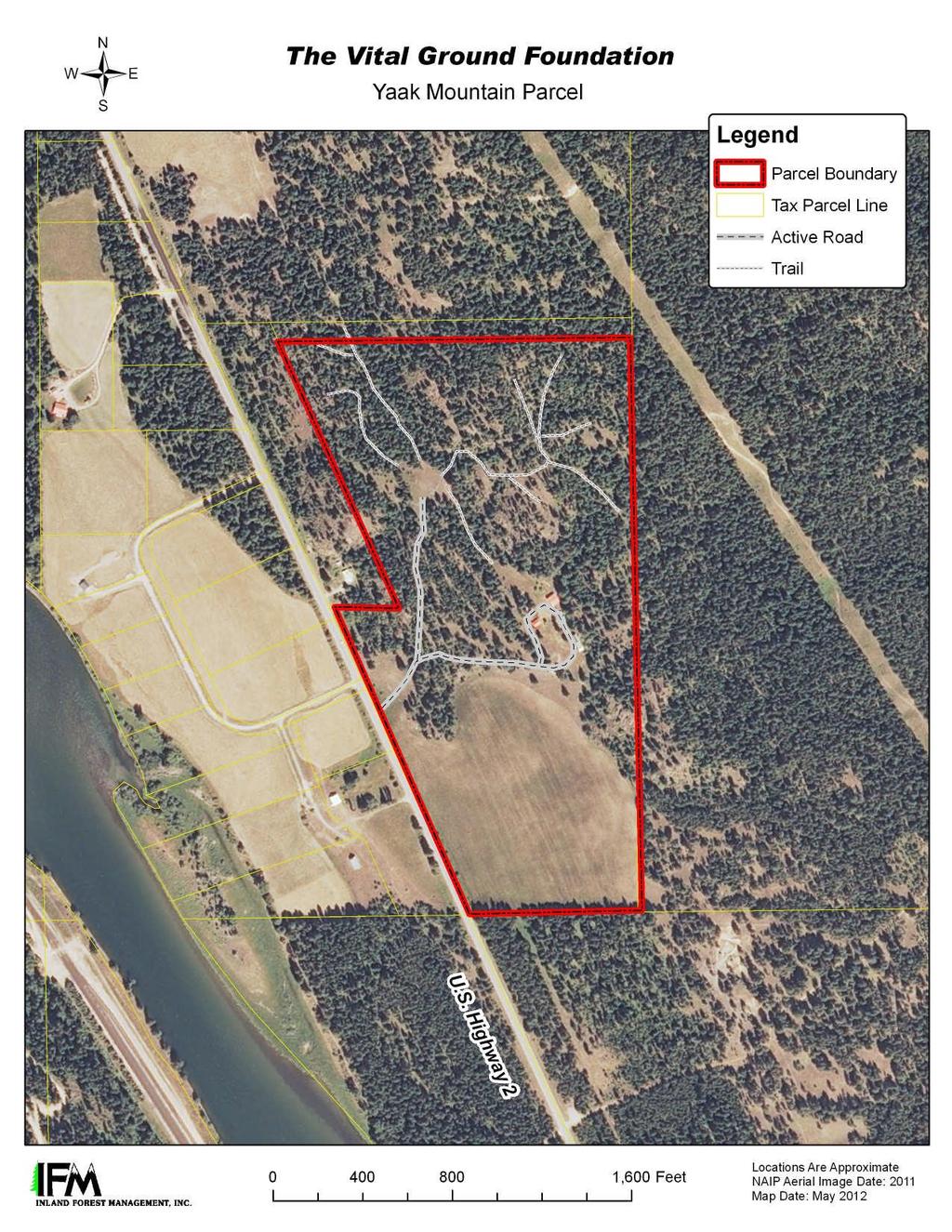
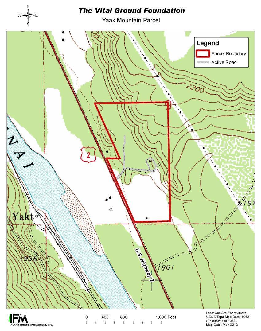
2 1) Property Details a. Montana Geocode: b. Acquisition date: July 31st, 2010 c. Method of acquisition: Fair market value, fee-title acquisition, from Terri L. Anderson d. Property size: 71 acres e. Property location (see locator map below) i. Nearest Town: Troy, MT (Lincoln County) ii. Legal description: TR-1 in the Southwest ¼, Section 9, Township 32 North, Range 34 West iii. Lat./Long: N, iv. Approximate elevation: 1900 ft. f. Physical description: The general landscape is characterized by nearly level to rolling terraces connected by steep risers. The terrain on this parcel features a level, alluvial terrace used for agriculture, a gently sloping lower terrace with forestland, and a steep, rocky riser that leads to an upper glacial outwash terrace. Aspect is generally southwest. Elevation ranges from 1,860 feet above sea level along the south boundary, to about 2,160 in the northeast corner. Average precipitation for the city of Troy, Montana is about 25.5 inches per year and the average annual temperature is 46.3 degrees F g. Access to property: This acre parcel is located about seven miles northwest of Troy, Montana near the confluence of the Kootenai and Yaak Rivers. A gated, gravel driveway provides direct access to an inactive homesite from U.S. Highway 2. A two-track, dirt-surfaced road leads to a log-landing site in the forestland that still contains a pile of old logs. Within the forestland, log skidding trails offer access by foot or ATV. One trail that leads to the northeast corner of the parcel has a very steep grade and may not be passable with an ATV. h. Forest stewardship or other existing plans: Inland Forest Management of Sandpoint, Idaho has produced a Vegetation Restoration Plan (May 2012) to help guide noxious weed treatment and restoration of native plant species on the property. Work began pursuant to that plan during Summer i. Previous land use(s): Prior to 2009, the open, lowest elevation portions of the property were used for pasture and hay production, while upland portions of the property show evidence of several forest entries. A central portion of the property was used residentially and to support agricultural operations, with development consisting of two abandon dwellings, a barn, two sheds, a non-functioning, drilled water well head and two 500-gallon above ground water tanks. This property does not contain any large springs, perennial or seasonal streams or ponds. A small, seasonal seep or spring is located east of the inactive home site. Portions of the field were flooded from snowmelt during March The well had an estimated production of 2
3 only 2 gallons per minute when it was operational, and it appears that a steady water source has been a struggle to maintain on this property. j. Legal information: No additional agreements are in place at this time, however, Vital Ground is evaluating the potential to enter into a hay production lease with the neighboring land owners (Jamie and Rose Lockman) - TBD during Spring
4 4
5 5
6 2) Current Status of species targeted for conservation The Cabinet-Yaak Grizzly Bear population is currently listed under the Endangered Species Act as a threatened species. The population has been deemed to be warranted for endangered status, but precluded by other priority species listings. There are an estimated grizzly bears in the Cabinet-Yaak Recovery Zone, with numbers approximately equally divided between the Canadian and U.S. portions of the ecosystems. The factors affecting grizzly bears in both British Columbia and northwest Montana are largely related to human development. One of the factors negatively affecting the Cabinet-Yaak grizzly population is a loss of seasonal habitat due to development on private lands in the lowlands, and there is recent evidence indicating that the population is fairly isolated genetically, potentially being sustained only due to recent efforts by the USFWS and MTFWP to augment the population. Sanitation is another issue of concern, as grizzly bears come into conflict at private residences seeking food rewards from garbage and other attractants that are not properly stored, and sanitation-related mortalities have occurred during the past five years. Canada Lynx, another animal listed as threatened, may occasionally range through this property. Canada Lynx typically require early successional forest stages for hunting its principal food source, snowshoe hare. They also require mature, closed canopy forest with a high density of downed logs and stumps for denning. Spaulding s Catchfly is another Threatened species found predominantly in the Pacific Northwest bunchgrass grasslands and sagebrush-steppe, and occasionally in open-canopy pine stands. This property does not contain riparian habitat or streams that contribute to fish habitat. 3) Adjacent land uses a. Kootenai National Forest: The Kootenai National Forest manages its lands in accordance with a multiple use mandate. The Forest Service has completed a survey of its common boundaries with the Yaak Mountain Property and USFS markers are plainly visible along the east and south borders of the property. The east line surveyed by the Forest Service does not coincide with the placement of the dilapidated barbed wire fence that served historically as the northern property boundary - via the updated survey, the Forest Service has corrected the southeast corner of the Yaak Mountain parcel in its favor. b. Private Residential/Agricultural (Jamie and Rose Lockman): Jamie and Rose Lockman own approximately 90 acres located north of the Yaak Mountain property. Development on that property is fairly clustered near Highway 2, with significant debris and junk on site. During 2012, Vital Ground permitted the Lockmans to hay the meadow portion of the Yaak Mountain parcel in exchange for addressing the significant weed infestation that had been allowed to develop during the years the meadow was fallow. We are evaluating the benefits to continuing that arrangement during the coming season. Vital Ground and the linkage initiative partners have targeted the Lockman property for a conservation if our relationship strengthens to make this possible. 6
7 c. Undeveloped Private Residential (Wild River Estates Subdivision): This holding is a 19- lot subdivision originally platted and listed for sale in 2009, and it is located imedieately across Highway 2 from the subject property. Only one of the lots has a structure on it at this time, and 11 of the original 19 lots are still actively listed for sale. Those listed lots are blocked together in the center of the subdivision. Early discussions with a local realtor indicate that the owner/seller is motivated and soliciting best offers, and Vital Ground has contracted for a preliminary valuation that would support an offer of approximately $450,000. The private lands working group of the Cabinet-Purcell Wildlife Habitat Linkage Initiative has encouraged Vital Ground to pursue a conservation outcome for the remaining holdings. d. Private Residential (Nystrom): Approximately nine acres along Highway 2 at the northwest corner of the subject property are privately owned and used for residential purposes. To date, Vital Ground has not had contact with the legal owner of this property. 4) Special management considerations/restrictions a. Pursuant to Vital Ground's Fee Title Land Stewardship Policies, the organization has determined that the existing improvements on the Yaak Mountain Property do not have a programmatic use, and they are scheduled to be removed to enhance the property s value for wildlife. Work to demolish and remove all improvements will begin in February 2013, with restoration of disturbed sites to continue through summer b. Pursuant to the 2012 Vegetation Restoration Plan (attached), Inland Forest Management will continue to work with Vital Ground through 2014 to control noxious weeds and restore native vegetation on the subject property. 5) Conservation goals, management objectives and management actions a. Conservation goal: Maximize the effectiveness of the property as a secure seasonal grizzly bear habitat and as linkage to larger adjacent blocks of protected wildlife habitat. Management Objective Restore the property to an undeveloped state o Management Action: Existing structures will be demolished during Management Objective Minimize conflicts between humans and grizzly bears o Management Actions: Limited non-motorized public access will be allowed only at times when there is likely to be little use by grizzly bears. Vital Ground will require written permission for public access. (See Recreational Activity Matrix) The property will be posted and monitored against trespass - especially during Montana's open hunting seasons. Management Objective Minimize opportunities for mistaken identification of grizzly bears to occur during bear hunting season. o Management Actions: Bear hunting is not allowed on the property. b. Conservation goal: Maintain and restore the ecological health of the land to support a diverse array of native flora and fauna. Management Objective Protect and restore native vegetation and maintain the property s usefulness for wildlife. 7
8 o Management Action: Vegetation restoration will continue until native vegetation can be maintained with little more than annual or semi-annual weed treatment. o Management Action: Continue to evaluate the benefits of leasing the hay ground to prevent encroachment by noxious weeds while maintaining some cover beneficial to wildlife. c. Conservation goal: Provide opportunities for conservation education and wildlife viewing activities that will not conflict with the property s usefulness to grizzly bears. Management Objective Maintain positive relations with adjacent landowners, partner agencies and the local community. o Management Actions: Maintain communication and collaboration with the Lockmans, while investigating opportunities for a conservation outcome for their property. Continue to evaluate an investment at the Wild River Estates subdivision. Public Recreation Activity Matrix Yaak Mountain Property ACTIVITY PERMITTED PROHIBITED CONDITIONS Public access for nonconsumptive Written permission required. activities Allowed only at times when such as hiking, bird there is likely to be little use by watching and wildlife grizzly bears. viewing. Motorized Public Access Camping Hunting - Bear Hunting Other Carnivores Hunting - Deer and Elk May be permitted with written permission only. Hunting - Waterfowl Hunting - Upland Bird May be permitted with written permission only. Trapping 6) Management funding and costs Vital Ground has established a Stewardship and Legal Defense Fund to assist with the ongoing stewardship and management costs for its conservation properties and easements. It is Vital Ground s policy to place $5,000 - $10,000 in the Stewardship and Legal Defense Fund for each conservation easement or land parcel acquired. These funds may be contributed by the landowner, a third-party donor, or transferred from another Vital Ground fund. This fund is managed as a quasi-endowment and its purpose is to: 8
9 Serve as a legal defense fund should Vital Ground ever have to defend a conservation easement through litigation. The fund corpus may be invaded for this purpose. Interest from the fund may be used to assist with the annual stewardship and maintenance costs associated with Vital Ground s conservation lands and easements. Following closing, Vital Ground placed $20,000 in the Stewardship and Legal Defense Fund on behalf of the Yaak Mountain Property. The organization budgeted an additional $35,000 to the stewardship costs associated with demolition of the structures and vegetation restoration activities, and has nearly met the fundraising goal for these expenditures. 7) Partnerships with other agencies and interested parties The Yellowstone to Yukon Initiative provided one half of the funding required to close this transaction, Vital Ground has subsequently partnered with the Trust for Public Land on a grant application to provide nearly 1/2 of the remaining stewardship/restoration expenses allocated to demolition and restoration of the developed sites on the proeprty. 8) Recommended monitoring schedule and areas of special emphasis Vital Ground land staff will conduct at least two monitoring visits semi-annually. However, these visits are occurring more frequently during the specific management activities currently ongoing at this location. 9
Cabinet- Purcell Trans- boundary Partnership. GNLCC Steering Committee Meeting Jackson, WY May 19, 2016
 Cabinet- Purcell Trans- boundary Partnership GNLCC Steering Committee Meeting Jackson, WY May 19, 2016 Yellowstone to Yukon Region Grizzly Bear Habitat Effectiveness Model Cabinet- Purcell Mountain Corridor
BURNEY GARDENS PLANNING UNIT Cow-Battle Creek Watershed
 Existing Conditions & Uses Overview Formerly homesteaded scenic mountain meadows and forestland surrounded by private timber and grazing lands 1,611 acres in Shasta County No FERC Project associated with
Statement of. Jim Stone, Rancher and Chairman Rolling Stone Ranch and The Blackfoot Challenge
 Statement of Jim Stone, Rancher and Chairman Rolling Stone Ranch and The Blackfoot Challenge Before the U.S. House of Representatives Subcommittee on National Parks, Forests, and Public Lands at the hearing
AVALONIA LAND CONSERVANCY FEE LAND STEWARDSHIP PRINCIPLES
 AVALONIA LAND CONSERVANCY FEE LAND STEWARDSHIP PRINCIPLES This document has been prepared for guidance in developing Property Management Plans for individual properties Avalonia owns in fee. It sets forth
LOWER DRUM PLANNING UNIT Yuba-Bear River Watershed
 Existing Conditions & Uses Overview Provides open space and recreation opportunities within the Sierra Nevada foothills 1,098 acres in Placer and Nevada Counties 789 acres outside the FERC boundary; 309
4 CONSERVED LANDS, PUBLIC LANDS, AND OTHER RECREATIONAL OPPORTUNITIES
 4 CONSERVED LANDS, PUBLIC LANDS, AND OTHER RECREATIONAL OPPORTUNITIES At the time of this study, there are approximately 2,300 acres of conservation land in Grantham, or 12% of the land area. The Town
TOWN OF SMYRNA Water Quality Buffer Zone Policy
 TOWN OF SMYRNA Water Quality Buffer Zone Policy Section I - Description A water quality buffer zone (a.k.a. a riparian zone) is a strip of undisturbed native (indigenous) vegetation, either original or
Central Washington 2012 Wildfires Burned Area Emergency Response (BAER) Information Brief October 19, 2012 BAER Information: (208)
 Information Brief October 19, 2012 BAER Information: (208)") Okanogan-Wenatchee National Forest Central Washington 2012 Wildfires Burned Area Emergency Response (BAER) Information Brief October 19, 2012 BAER Information: (208) 398-3348 Fire Background WENATCHEE
Okanogan-Wenatchee National Forest Central Washington 2012 Wildfires Burned Area Emergency Response (BAER) Information Brief October 19, 2012 BAER Information: (208) 398-3348 Fire Background WENATCHEE
Appendix E : Guidelines for Riparian Buffer Areas
 Appendix E : Guidelines for Riparian Buffer Areas This document should be read in conjunction with the CRCA Planning Policy. 1.0 PURPOSE The purpose of this document is to summarize the recommendations
(1) The proposed commercial solar energy generation facility is either
 The proposed commercial solar energy generation facility is either") (2) The design and siting of these facilities shall avoid the placement of turbines on or immediately adjacent to the upwind side of ridge crests; (3) The design may include other design features to minimize
(2) The design and siting of these facilities shall avoid the placement of turbines on or immediately adjacent to the upwind side of ridge crests; (3) The design may include other design features to minimize
14. Sustainable Forestry Principals
 14. Sustainable Forestry Principals Fish River Lakes Concept Plan Addendum Materials April 2018 14. SUSTAINABLE FORESTRY PRINCIPLES In response to our discussion with LUPC Staff and others on the topic
FISHER. Scientific Name: Martes pennanti columbiana Species Code: M-MAPE. Status: Blue-listed
 Scientific Name: Martes pennanti columbiana Species Code: M-MAPE Status: Blue-listed FISHER Distribution Provincial Range Fishers are distributed throughout the mainland of British Columbia, east of the
MAWG "Middle Ground" Proposal Jackson Hole Conservation Area Prescriptions
 MAWG "Middle Ground" Proposal Jackson Hole Conservation Area Prescriptions We recommend the designation of several Jackson Hole Conservation Areas (JHCA) totaling approximately 214,000 acres to be comprised
Introduction. Background
 Introduction Snow Forest Day Use Recreation Area Project Mountaintop Ranger District, San Bernardino National Forest San Bernardino County, California October 9, 2009 The Mountaintop Ranger District, San
MISSOULA CONSERVATION DISTRICT 2018 COST-SHARE APPLICATION
 MISSOULA CONSERVATION DISTRICT 2018 COST-SHARE APPLICATION 3550 Mullan Road, Suite 106 Missoula, MT 59808-5125 Phone: (406) 829-3395 x 101 Email: info@missoulacd.org Website: www.missoulacd.org OFFICE
Clarks Fork of the Yellowstone Comprehensive River Management Plan
 Clarks Fork of the Yellowstone Comprehensive River Management Plan Background The Clarks Fork of the Yellowstone River is located on the Shoshone National Forest, approximately 30 miles north-northwest
Wildlife Conservation Strategy
 Wildlife Conservation Strategy Boise National Forest What is the Wildlife Conservation Strategy? The Boise National Forest is developing a Wildlife Conservation Strategy (WCS) in accordance with its Land
Kobe Pumping Plant and Pipeline Project Narrative UPDATED 6/28/13
 Kobe Pumping Plant and Pipeline Project Narrative UPDATED 6/28/13 Introduction/Background The Kobe Pumping Plant and Pipeline (the Project ) is located in Mesa and Garfield Counties near DeBeque, Colorado.
DECISION MEMO Robinhood Creek Helicopter Log Deck June, 2008
 DECISION MEMO Robinhood Creek Helicopter Log Deck June, 2008 USDA Forest Service, Mt. Hood National Forest Hood River Ranger District Hood River County, Oregon Flooding in the fall of 2006 caused significant
PROJECT HIGHLIGHTS,
 PROJECT HIGHLIGHTS, 2012-003 935 linear feet of fence encompassing livestock pond 1 water tank, 2 water troughs, 3800 linear feet pipeline Project: 2012-003 Watershed: Tomales Bay, East Shore Practices:
KINGS RIVER PLANNING UNIT Kings River Watershed
 Existing Conditions & Uses Overview Remote parcel in rugged canyon with adjoining whitewater rafting base camps 100 acres in Fresno County The Kings River Planning Unit is outside any FERC Project boundary
INTERIM MANAGEMENT PLAN. Silver Lake Woods
 INTERIM MANAGEMENT PLAN Silver Lake Woods August 6, 2016 INTERIM MANAGEMENT PLAN Silver Lake Woods August 6, 2016 Goal of the Management Plan. The Town of Georgia Conservation Commission has prepared this
Wildlife Conservation Lands Program. Deanna Noble
 Wildlife Conservation Lands Program Deanna Noble Forest Stewardship Biologist June 19, 2012 Introduction Legislation that recognizes wildlife conservation land as a special class of property that must
DECISION MEMO. Crow Creek Hardened Crossing
 Page 1 of 5 DECISION MEMO USDA Forest Service Madison Ranger District Madison County T12S, R4W in Section 35 Background A perennial cattle crossing on Crow Creek in in the Gravelly Landscape in the Centennial
DECISION MEMO. West Fork Blacktail Deer Creek Hardened Crossing
 Page 1 of 6 Background DECISION MEMO USDA Forest Service Madison Ranger District Madison County T12S, R4W, Section 30 The project is in the Gravelly Landscape, Snowcrest Recommended Wilderness Management
CARRIZO PLAIN PLANNING UNIT Carrizo Plain
 Existing Conditions & Uses Overview About one square mile of cropland and grassland, much of which until recently supported a solar power generation facility, in a remote and lightly populated agricultural
ELK RAPIDS TOWNSHIP WATER QUALITY ACTION PLAN
 ELK RAPIDS TOWNSHIP WATER QUALITY ACTION PLAN Elk-River-Chain-of-Lakes Gaps Analysis Project The Watershed Center Grand Traverse Bay Tip of the Mitt Watershed Council Michigan Department of Natural Resources
The following recommendations will need to be re-evaluated given the recent fire at the Kennedy Meadows Pack Station.
 Kennedy Meadows Planning Unit The following recommendations will need to be re-evaluated given the recent fire at the Kennedy Meadows Pack Station. Sustainable Forestry Evaluate existing timber inventory
Appendix J. Forest Plan Amendments. Salvage Recovery Project
 Forest Plan Amendments Salvage Recovery Project APPENDIX J Lynx and Old Growth Forest Plan Amendments CHANGES BETWEEN DRAFT EIS AND FINAL EIS Changes in Appendix J between the Draft and Final EIS include:
Final Report of the Riparian Forest Buffer Panel
 Chesapeake Bay Program Final Report of the Riparian Forest Buffer Panel Introduction Findings Land Use-Specific Findings On Agricultural Land On Forested Land On Developed and Developing Lands Recommendations
Proposed Wildlife Habitat Restoration Project At Walking Iron Wildlife Area August 6, 2015
 Proposed Wildlife Habitat Restoration Project At Walking Iron Wildlife Area August 6, 2015 Walking Iron County Wildlife Area is 898 acres situated in the Town of Mazomanie between Walking Iron County Park
FORDYCE LAKE PLANNING UNIT Yuba-Bear River Watershed
 Existing Conditions & Uses Overview Scenic, high elevation reservoirs adjacent to the Tahoe National Forest with important biological and recreation resources 2,279 acres in Nevada and Placer Counties;
Wilderness, Wildlife, and Ecological Values of the Hyalite-Porcupine-Buffalo Horn Wilderness Study Area Executive Summary
 Wilderness, Wildlife, and Ecological Values of the Hyalite-Porcupine-Buffalo Horn Wilderness Study Area Executive Summary This 155-page report is a review of existing data and literature that were available
CHAPTER 2 - ALTERNATIVES
 CHAPTER 2 - ALTERNATIVES Introduction This chapter describes the proposed action and 2 alternatives to the proposed action. This chapter is intended to provide the decision-maker the basis for choice.
APPENDIX P EL DORADO COUNTY GENERAL PLAN: APPLICABLE SECTIONS FROM CONSERVATION AND OPEN SPACE ELEMENT
 APPENDIX P EL DORADO COUNTY GENERAL PLAN: APPLICABLE SECTIONS FROM CONSERVATION AND OPEN SPACE ELEMENT SOIL CONSERVATION OBJECTIVE 7.1.2: EROSION/SEDIMENTATION Minimize soil erosion and sedimentation.
Forest Stewardship Program
 Forest Stewardship Program James Starr, Forest Management 06/2003 Purpose of Forest Stewardship Program is to assist private forest landowners in more actively managing their forest and related resources;
Bear River Planning Unit. Fish, Plant, and Wildlife Habitat BEAR RIVER PLANNING UNIT
 BEAR RIVER PLANNING UNIT Yuba-Bear River Watershed Bear River Planning Unit Above all, the Stewardship Council recommends close coordination with the upcoming relicensing effort to ensure consistency with
The Galton Project Kootenai National Forest. The Galton Project
 Introduction The Galton Project The Fortine Ranger District of the Kootenai National Forest is in the early stages of developing a project entitled Galton, named for the mountain range dominating the eastern
Forest Stewardship Management Plan
 Forest Stewardship Management Plan James Starr, Forest Management 06/2003 Forest Stewardship Management Plans Plans must identify and describe actions to protect, manage, maintain and enhance relevant
The Wyoming Wildlife Advocates also value the Caribou-Targhee National
 May 20, 2016 Jay Pence District Ranger USDA Forest Service Caribou-Targhee National Forest P.O. Box 777 Driggs, ID 83422 Re: Comments on the proposed Southern Valley Recreation Project, submitted to the
GAYLORD FOREST MANAGEMENT UNIT COMPARTMENT REVIEW PRESENTATION COMPARTMENT: 190. ENTRY YEAR: 2010 Compartment Acreage: 2,401 County: Cheboygan
 DNR DEPARTMENT OF NATURAL RESOURCES GAYLORD FOREST MANAGEMENT UNIT COMPARTMENT REVIEW PRESENTATION COMPARTMENT: 10 ENTRY YEAR: 2010 Compartment Acreage: 2,401 County: Cheboygan Revision Date: April 2,
Appendix B Adaptive Management Strategy
 Adaptive Management Strategy This appendix identifies the adaptive management strategy that would be implemented as part of the proposed action. This strategy and the processes contained and described
COLORADO FOREST LEGACY PROGRAM APPLICATION FOR 2019 FUNDS
 COLORADO FOREST LEGACY PROGRAM APPLICATION FOR 2019 FUNDS The Colorado Forest Legacy Program purpose is to protect environmentally important private forest areas that are threatened by conversion to non-forest
s. w. Wolff T.A. Wesche W.A. Hubert
 ASSESSMENT OF A FLOW ENHANCEMENT PROJECT AS A RIPARIAN AND FISHERY HABITAT MITIGATION EFFORT s. w. Wolff T.A. Wesche W.A. Hubert 1986 Symposium Proceedings WWRC - 8 6-20 In Proceedings of the Twenty-First
Chapter 13: Wildlife and Vegetation
 Chapter 13: Wildlife and Vegetation Introduction and Setting Nevada County contains an extremely wide range of plants, animals and habitat types. With topographic elevations ranging from 300 feet in the
Public Notice ISSUED: 11 February 2019 EXPIRES: 13 March 2019
 SPONSOR: Minnesota Board of Water and Soil Resources Public Notice ISSUED: 11 February 2019 EXPIRES: 13 March 2019 REFER TO: MVP-2019-0122-JTB SECTION: 404 - Clean Water Act 1. WETLAND COMPENSATORY MITIGATION
FINDING OF NO SIGNIFICANT IMPACT OWL CREEK GRAVEL PIT EXPANSION U.S. FOREST SERVICE
 FINDING OF NO SIGNIFICANT IMPACT OWL CREEK GRAVEL PIT EXPANSION U.S. FOREST SERVICE OURAY RANGER DISTRICT OURAY COUNTY, COLORADO BACKGROUND The Owl Creek Gravel Pit, also known as the Spruce Ridge Pit,
THE MISSISSIPPI RIVER TRUST
 THE MISSISSIPPI RIVER TRUST Operates as a land trust in six states along the Lower Mississippi River. Primary tool is the conservation easement, which allows willing landowners to protect important ecological
Proposed Action and Alternatives
 Chapter Proposed Action and Alternatives Page 15 CHAPTER 2 - PROPOSED ACTION AND ALTERNATIVES INTRODUCTION Chapter 2 describes and compares the Southwest Fence Relocation and Waterline Project s Proposed
In 2013, Gunnison sage-grouse was proposed for an "endangered" listing by the U.S. Fish and Wildlife Service under the Endangered Species Act.
 Gunnison County, CO Community Development Department 221 N. Wisconsin St. Ste. D Gunnison, CO 81230 (970) 641-0360 Website: www.gunnisoncounty.org Email: planning@gunnisoncounty.org Information Sheet:
United States Department of Agriculture. Forest Service. Beaverhead-Deerlodge National Forest. September 2014
 United States Department of Agriculture Forest Service Beaverhead-Deerlodge National Forest September 2014 Beaverhead-Deerlodge National Forest Land and Resource Management Plan Explanation Supporting
UNITY, OREGON CATTLE RANCH
 64347 HARNEY AVE CRANE, OR 987.62 DEEDED ACRES THREE TAX LOTS 445.1 ACRES WATER RIGHTS FOR NATIVE MEADOW HOME, BARN, 2 SHOPS, CORRALS UNITY, OREGON CATTLE RANCH 191 HEAD FOREST PERMIT, 2 HEAD BLM PRIVATE
DECISION MEMO. Missoula Electric Cooperative Point 118. MEC - Buried Electric Powerline (Along West Fork Butte Access Road #37 to Point 118)
") DECISION MEMO Missoula Electric Cooperative Point 118 MEC - Buried Electric Powerline (Along West Fork Butte Access Road #37 to Point 118) USDA Forest Service - Lolo National Forest Missoula Ranger District
DECISION MEMO Missoula Electric Cooperative Point 118 MEC - Buried Electric Powerline (Along West Fork Butte Access Road #37 to Point 118) USDA Forest Service - Lolo National Forest Missoula Ranger District
BOARD OF WILDLIFE COMMISSIONERS
 Wildlife Heritage Account Project Proposal Form APPLICANT INFORMATION Person/Organization/Agency: Nevada Department of Wildlife (NDOW) Date: 8 January 2017 Name: Moira Kolada Title: Habitat Biologist Address:
Hubbard Lake State Game Area Master Plan
 Hubbard Lake State Game Area Master Plan MICHIGAN DEPARTMENT OF NATURAL RESOURCES WILDLIFE DIVISION BRIAN PICCOLO AUGUST 2017 Intended Purpose and General Management Direction Hubbard Lake State Game Area
LIMITED ENVIRONMENTAL REVIEW
 Division of Environmental and Financial Assistance Office of Financial Assistance Water Resource Restoration Sponsor Program LIMITED ENVIRONMENTAL REVIEW A. Project Identification Project Name: Project
Proposed Action and Alternatives
 Chapter Proposed Action and Alternatives Chapter 2 Proposed Action and Alternatives Page 15 CHAPTER 2 - PROPOSED ACTION AND ALTERNATIVES INTRODUCTION Chapter 2 describes and compares the Southwest Fence
Decision Notice Finding Of No Significant Impact
 Decision Notice Finding Of No Significant Impact U. S. Forest Service Southern Region Land Between The Lakes National Recreation Area Golden Pond, Kentucky Environmental Assessment for Prior Creek Project
DETAILED IMPACT ANALYSIS OF MARMOT BASIN LONG RANGE PLAN
 2.0 JURISDICTION Parks Canada s decisions about the acceptability of proposals presented in the LRP are guided by a number of regulatory instruments and policies, the most relevant of which are described
Environmental Trail Screening Tool. Legislation & Guidelines. Legislation/Guidelines. Implications for Trail Development
 This Legislation & Guidelines Matrix is a resource to accompany the developed by Recreation Sites and s BC. Legislation & Guidelines Legislation/Guidelines Assessment Act Applicability (Federal and Provincial)
Introduction. Property Boundary and Survey Evidence
 Introduction The Peacham Town Forest is approximately 190 acres of land located in the Northwest corner of the town, close to the town line with Cabot. The tract is the former Ike Peck farm and was acquired
Goose Creek Watershed Assessment Summary October 2003
 Goose Creek Watershed Assessment Summary October 2003 The Goose Creek Watershed The Goose Creek watershed is 385 square miles, covering nearly half of Loudoun County and one-quarter of Fauquier County
APPENDIX N. Northern Rockies Lynx Management Direction, and Northern Rockies Lynx Standards and Guidelines
 APPENDIX N. Northern Rockies Lynx Management Direction, and Northern Rockies Lynx Standards and Guidelines This attachment evaluates project compliance with applicable Northern Rockies Lynx Management
UNITY, OREGON CATTLE RANCH
 64347 HARNEY AVE CRANE, OR 987.62 DEEDED ACRES THREE TAX LOTS 445.1 ACRES WATER RIGHTS FOR NATIVE MEADOW HOME, BARN, 2 SHOPS, CORRALS UNITY, OREGON CATTLE RANCH 191 HEAD FOREST PERMIT, 2 HEAD BLM PRIVATE
FALL RIVER MILLS PLANNING UNIT Pit-McCloud River Watershed
 Existing Conditions & Uses Overview Scenic lake and river corridor adjacent to the town of Fall River Mills; 5,310 acres in Shasta County 4,732 acres outside the FERC boundary; 578 acres inside the FERC
RECREATIONAL FARM FOR SALE acres in Sangamon County, Illinois
 320 S. Crossing Dr. P. O. Box 169 Sherman, IL 62684 217-496-3500 RECREATIONAL FARM FOR SALE 211. 42 acres in Sangamon County, Illinois Located five miles east of Springfield, Illinois In the middle of
PRINCE GEORGE NATURAL AREAS AND THE EFFECTS OF CLIMATE CHANGE: CASE STUDY
 PRINCE GEORGE NATURAL AREAS AND THE EFFECTS OF CLIMATE CHANGE: CASE STUDY Natural Areas in Prince George The City of Prince George is dominated by natural, undeveloped areas within city limits and in adjacent
Community Workshops Summary Prepared February 2016
 Community Workshops Summary Prepared February 2016 Introduction Stevens County is preparing an updated Shoreline Master Program (SMP), and the City of Kettle Falls and the towns of Marcus and Northport
Sawmill Creek Ranch. Mule Creek, New Mexico. Representing Western Ranchers with the Values of Yesterday and the Technology of Today
 Sawmill Creek Ranch Mule Creek, New Mexico Representing Western Ranchers with the Values of Yesterday and the Technology of Today Sawmill Creek Ranch $5,000,000 Land Status Approximately 1,514 Deeded Acres
COASTAL CONSERVANCY. Staff Recommendation June 16, 2005 ESTERO AMERICANO NATURE PRESERVE ENHANCEMENT PROJECT
 COASTAL CONSERVANCY Staff Recommendation June 16, 2005 ESTERO AMERICANO NATURE PRESERVE ENHANCEMENT PROJECT File No. 05-017 Project Manager: Richard Retecki RECOMMENDED ACTION: Authorization to disburse
State Forest Management: Pennsylvania
 State Forest Management: Pennsylvania April 14, 2010 Jim Grace Deputy Secretary for State Parks and Forestry Pennsylvania DCNR PENNSYLVANIA M Pennsylvania s Forests 16.6 million ac.(6.7 million ha.) of
FLOODPLAIN PERMIT APPLICATION SUBMITTAL REQUIREMENTS
 Planning Department 215 South 4 th Street, Suite F Hamilton, MT 59840 Phone 406-375-6530 Fax 406-375-6531 planning@rc.mt.gov FLOODPLAIN PERMIT APPLICATION SUBMITTAL REQUIREMENTS To initiate the permit
Public Notice ISSUED: April 12, 2019 EXPIRES: May 13, 2019
 APPLICANT: Bad River Band of Lake Superior Chippewa Tribe Public Notice ISSUED: April, 09 EXPIRES: May 3, 09 REFER TO: 08-03046-JMB SECTION:404 - Clean Water Act. APPLICATION FOR PERMIT TO discharge fill
April 5th Meeting Agenda
 Pend Oreille County Voluntary Stewardship Program April 5th Meeting Agenda Welcome and Meeting Overview Follow up from last Work Group meeting Review details in Sections 2 and 3 prepared since last meeting
Fish Habitat Protection Development Permit Area
 Appendix A2 3 Fish Habitat Protection Development Permit Area 1.0 PURPOSE: The area shown on Map No. 7 as the Fish Habitat Protection Development Permit Area is designated for the purpose of protecting
Tenmile and Priest Pass Restoration Project Scoping Notice
 Introduction Tenmile and Priest Pass Restoration Project Scoping Notice USDA Forest Service Helena National Forest Helena Ranger District Lewis and Clark County, Montana The Helena Ranger District of the
Compartment Review Presentation
 Revision Date: 06/17/2014 Stand Examiner: Jeff Wise Legal Description: T44N, R1W, Sec 29, 32 Compartment Review Presentation Sault Ste. Marie Forest Management Unit Compartment Entry Year Acreage: County
3.28 RESEARCH NATURAL AREAS
 3.28 RESEARCH NATURAL AREAS Introduction Research Natural Areas (RNAs) are areas designated, in perpetuity, for non-manipulative research and educational purposes, as well as to help maintain ecological
State and Private Forestry Fact Sheet. Investment in State's Cooperative Programs:
 State and Private Forestry Fact Sheet 2015 Idaho Investment in State's Cooperative Programs: Program FY 2014 Final Community Forestry and Open Space $0 Cooperative Lands - Forest Health Management $364,500
DECISION RECORD for the Rattlesnake Negotiated Timber Sale (Reference:
 DECISION RECORD for the Rattlesnake Negotiated Timber Sale (Reference: Bly Mtn. / Swan Lake / Rattlesnake Reservoir Forest Health and Woodland Treatments Environmental Assessment #OR014-99-6) Introduction
ATTACHMENT 2A- Issues Tentatively Resolved Decisions from the Board of Supervisors Hearing on September 11, 2007
 1. Introduction (on pg 1-15) Add the following goal: A Community safe from climate change. Marin will be a leader in averting and adapting to aspects of climate change. 2. Biological Resources 2.A. Richardson
The Science Behind Forest Riparian Protection in the Pacific Northwest States By George Ice, Summer 2004
 The Science Behind Forest Riparian Protection in the Pacific Northwest States By George Ice, Summer 2004 Riparian buffers, streamside management zones, and similar measures are essential parts of forest
Public Notice ISSUED: EXPIRES:
 SPONSOR: City of Superior Public Notice ISSUED: EXPIRES: REFER TO: 2015-04234-WMS SECTION:404 - Clean Water Act 1. WETLAND COMPENSATORY MITIGATION BANK PROPOSAL 2. SPECIFIC INFORMATION. SPONSOR S ADDRESS:
USDA Forest Service Decision Memo. Mattie V Creek Minesite Rehabilitation Project
 USDA Forest Service Decision Memo Mattie V Creek Minesite Rehabilitation Project Ninemile Ranger District Lolo National Forest Mineral County, Montana I. DECISION TO BE IMPLEMENTED A. Decision Description:
I am posting this letter, along with maps on the National Forests in North Carolina website, at:
 United States Forest National Forests in North Carolina 90 Sloan Rd Department of Service Nantahala National Forest Franklin, NC 28734-9064 Agriculture Nantahala Ranger District 828-524-6441 Dear Forest
Poker Chip Project. Noxious Weed Risk Assessment Almanor Ranger District Lassen National Forest
 Noxious Weed Risk Assessment Almanor Ranger District Lassen National Forest June 3, 2013 Introduction When a ground-disturbing action or activity is proposed, a Noxious Weed Risk Assessment (NWRA) determines
CITY POLICY POLICY NUMBER: C531 REFERENCE: ADOPTED BY: City Council Council July 2007 SUPERSEDES: Policy C467
 CITY POLICY REFERENCE: ADOPTED BY: City Council Council 1995 07 25 17 July 2007 SUPERSEDES: Policy C467 PREPARED BY: Office of Natural Areas DATE: 5 June 2007 Policy Statement: Since Edmonton was settled
Indian Creek Ranch. Presents. Brusett, Montana
 Presents Brusett, Montana PO BOX 1231 2515 Main Street Miles City, MT 59301 Office: (406)234-1523 Monty Cell: (406) 853-1523 Rob Cell: (406)853-2066 Vance cell (406)951-4431 Website: leshandcompany.com
Childs Meadow Fence Project Almanor Ranger District, Lassen National Forest
 Childs Meadow Fence Project Almanor Ranger District, Lassen National Forest Tehama County, California April 6, 2015 Introduction The Almanor Ranger District (ALRD) of the Lassen National Forest (LNF) proposes
APPENDIX Y SEPA CHECKLIST AND DNS
 APPENDIX Y SEPA CHECKLIST AND DNS Planning & Development Services Division Current Planning Section 840 Northgate Drive Richland, WA 99352 509/942-7598 FAX 509/942-7764 State Environmental Policy Act
File Code: 1900 Date: June 14, Dear Interested Parties,
 Logo Department Name Agency Organization Organization Address Information United States Forest National Forests in North Carolina 632 Manor Road Department of Service Appalachian Ranger District Mars Hill,
County of Sonoma Agenda Item Summary Report
 County of Sonoma Agenda Item Summary Report Agenda Item Number: 55 (This Section for use by Clerk of the Board Only.) Clerk of the Board 575 Administration Drive Santa Rosa, CA 95403 To: Board of Supervisors
DRAFT FINDING OF NO SIGNIFICANT IMPACT. for. Tioga Sports Park
 DRAFT FINDING OF NO SIGNIFICANT IMPACT for Tioga Sports Park The U.S. Fish and Wildlife Service (USFWS) prepared an Environmental Assessment (EA) to analyze the potential effects of the proposal by the
WQMP AMENDMENT REVIEW CHECKLIST
 State of New Jersey Highlands Water Protection and Planning Council 100 North Road (Route 513) Chester, New Jersey 07930-2322 (908) 879-6737 (908) 879-4205 (fax) www.highlands.state.nj.us WQMP AMENDMENT
ENVIRONMENTAL CHECKLIST
 City of Hoquiam Planning and Building Division 609 8 th St. Hoquiam, WA 98550-3522 Tel: 360-532-5700 ext. 211, Fax: 360-538-0938 Website: www.cityofhoquiam.com ENVIRONMENTAL CHECKLIST Purpose of checklist:
LAND USE ALLOCATIONS AND MANAGEMENT GOALS for POLALLIE-COOPER PLANNING AREA. Mt. Hood Land and Resource Management Plan (Forest Plan)
") LAND USE ALLOCATIONS AND MANAGEMENT GOALS for POLALLIE-COOPER PLANNING AREA Mt. Hood Land and Resource Management Plan (Forest Plan) Primary Land Use Allocations within Planning Area: B2-Scenic Viewshed
LAND USE ALLOCATIONS AND MANAGEMENT GOALS for POLALLIE-COOPER PLANNING AREA Mt. Hood Land and Resource Management Plan (Forest Plan) Primary Land Use Allocations within Planning Area: B2-Scenic Viewshed
Final Decision Memo. Murphy Meadow Restoration Project. USDA Forest Service Willamette National Forest McKenzie River Ranger District
 Final Decision Memo Murphy Meadow Restoration Project USDA Forest Service Willamette National Forest McKenzie River Ranger District T19S, R5E, Sec. 23, 24. Lane County Oregon BACKGROUND The Murphy Meadow
Keefer Pasture Drift Fence Project. Challis-Yankee Fork Ranger District Salmon-Challis National Forest
 Keefer Pasture Drift Fence Project Challis-Yankee Fork Ranger District Salmon-Challis National Forest PROPOSED ACTION The Challis-Yankee Fork Ranger District proposes construction of approximately.11 miles
RESTORATION OF RARE PLANTS OF THE PALOUSE. Trish Heekin Conservation Planner Latah Soil and Water Conservation District
 RESTORATION OF RARE PLANTS OF THE PALOUSE Trish Heekin Conservation Planner Latah Soil and Water Conservation District Rare Plants of the Palouse We ve already covered What are they? Where do they occur?
SEPA Environmental Checklist
 Purpose of the Checklist: The State Environmental Policy Act (SEPA), chapter 43.21 RCW, requires all governmental agencies, including the City of Ferndale to consider the environmental impacts of a proposal