Taking New Tropical Peat Fire Evaluation Methods Nation-wide In Indonesia
|
|
|
- Arron York
- 6 years ago
- Views:
Transcription


1 Taking New Tropical Peat Fire Evaluation Methods Nation-wide In Indonesia Laura Graham, Grahame Applegate, Andri Thomas, Erianto Indra Putra, Kevin Ryan and Mark Cochrane part of the NASA-funded SDSU-IPB Peat Fire Research Project


2 GHG emissions from peat fires and limitations in monitoring methodologies Each year thousands of hectares of peatland burn in Indonesia emitting tonnes of greenhouse gasses, particulates, and aerosols. Current estimates calculate up to 114 t C ha -1 released. Emission calculations for tropical peat in relation to fire are based upon limited field peat fire behaviour and related carbon loss data, as noted in IPCC. Methodology and data on tropical peat fires behaviour and emissions must be improved for Indonesia to participate fully in carbon accountancy, to manage their peatlands, and to prevent and control peat fires. Photo: Photo: outrop.co.uk


3 SDSU-IPB Peat Fire Research Project A joint Indonesian-US project, the South Dakota State University (SDSU) Institut Pertanian Bogor (IPB) Peat Fire Research Project was established, funded by NASA. How and why peatland surface fires transition to smouldering peat fires, and how these events might be recognised and characterised by satellite. An integral component to this project is the field-based collection of biophysical data relating to peat fires Phase I ( ): To develop appropriate and transferable methods for collecting peat fire data and to facilitate improved emissions calculations that could be used at this focal site and elsewhere. Phase II ( ): Trial these methods at a national scale across four provinces, and collect nation-wide data


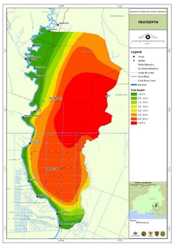
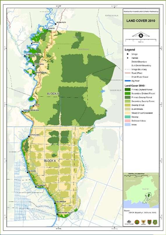
4 The Phase I core study site Melanjut
 During the dry")
, and introduces the new, additional studysites in which data will be collected,")
5 Methodology development The project began activities in the BOS- Mawas area in June Field activities include fuel, hydrology and vegetation monitoring and investigating fire-related human actions (not presented) During the dry season develop methods for and conduct fire scene evaluations including peat fire behaviour components This paper presents methods developed, initial data from the fire seasons (August-November), and introduces the new, additional studysites in which data will be collected, and the amalgamated at a national-scale during Phase II

6 Fire reporting and selection Two fire reporting techniques: Daily updates from NASA s Aqua and Terra satellites, and NOAA, reporting hotspots in the Mawas area. BOS-Mawas Patrol team and the local communities sms and telephone to report fires. If multiple fire locations are reported, the team prioritises Fires where peat is burning deep peat locations, locations that have recorded three or fewer previous burns, locations that represent different environmental conditions as compared to those previously evaluated
 published FSE field manual has been developed which provides field worksheets and")


7 Fire Scene Evaluation A 65-question fire scene evaluation (FSE) form has been developed. A (soon) published FSE field manual has been developed which provides field worksheets and descriptions and explanations for each question to ensure answers are comparable between sites and fires. The form requires each question given a confidence rating and photo documentation for future crosschecking by experts The FSE form consists of two parts. - Part I general environmental and fire datacollection. - Part II which is more-detailed and includes peat and peat-fire questions.
8 Fire Scene Evaluation Part Section Type of data collected I Fire identification Dates and unique fire code Fire control Authorities involved Fire information & location Maps, access routes, fire reporting, ignition point GPS, source and cause, start/end dates, land tenure, land use Weather Wind speed, direction, relative humidity, temperature conditions Surface fire - Height of burn, scorch height, depth of surface fuel burnt, vegetation type intensity Peat fire Peat burn depth, estimate of area burnt, water table depth, fuel load Fire damage info Area burned, infrastructure, vehicles, houses, animals, crops lost or damaged Fire sketch Detailed sketch of area, fire, land tenure, recoded data points etc. II Fire identification Dates and unique fire code Peat fire Peat ignition point, source, description, weather, moisture content, depth. Fuel size, availability, ignition potential Fuel Fine, medium, heavy fuel load triangles, fuel descriptions Assessing the burned area Vegetation type and loss, fuel type and loss, evidence of fuel blackening, charring, scoring, peat decomposition stage, signs of previous burns Human action observations Human nearby land-use, human use of weather or other biophysical features to start, spread or modify the fire

: The")


 x 3 replicates Medium 2.5 7.")

9 Fuel loads and water table depth At an unburned area adjacent to where the peat has burned, and ahead of the direction of fire, the surface fuel is assessed The Line Intersect Method (triangular transect): The diameter of each fuel item (dead trunks, roots, branches, etc.) that intersects the line is measured at the point where it bisects the line. Fuel Type Diameter Triangle transect length Fine >7.5 cm 1 x 1 m (dry weight) x 3 replicates Medium cm 30 m Heavy < 2.5 cm 90 m Two dipwells inserted 10 m behind and 10 m in-front of the peat-fire interface. The water table depth is measured the next day using the blow-straw method.


10 The peat moisture content at the peatfire interface At the peat fire interface a section of peat is dug away, perpendicular to the interface, approx. 50 x 50 cm in area. Half way down, and parallel to the fire interface, peat samples are cored into the excavated wall, at 5, 10, 15, 25 cm horizontally, and every 10 cm additionally, away from the interface, until the peat is cool to touch. Samples are then taken at 5, 10, 15, 25 cm vertically down, until the peat is again cool. These peat samples are weighed, dried to a constant weight, then weighed again in a lab. The percentage moisture content is then calculated.


11 The rate of peat fire spread At the point of smouldering peat, five uniquely numbered metal rods are inserted into the burning face of the peat. Each rod has a line etched into it, and each rod is inserted into the peat until the etch point is at the height of the peat surface, with approx. 40 cm between each rod. This layout is repeated at three positions around the edge of the peat fire. After 24 hours, the rods are re-measured with the depth of burn and the horizontal distance and direction to the closest point on the peat-burn face recorded. Data can be collected over several days.


12 Volume of peat lost from the burn A 160 cm square is strung with cords to form a 20 cm x 20 cm grid creating a square matrix with 81 intercept points. Set-up in the field horizontally, at 1 m above surface, in the direction of movement of the fire and ahead of the peat-fire interface. At every intersection the distance to the unburnt peat surface is measured, creating an x, y, z measurement. Four metal rods are inserted into the peat to mark the location, with etches on the rods to mark the position of the peat surface. This is repeated at three positions. After the fire has passed through the peat (several days), squares are re-established and x, y, z re-measured, taking into account the new peat surface, allowing change in peat surface volume to be calculated.


13 To support field activities and facilitate field decision making, a field activity flow diagram has been developed which is part of the FSE manual FSE Field activities

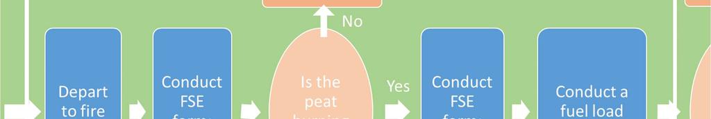

14 FSE Field activitie

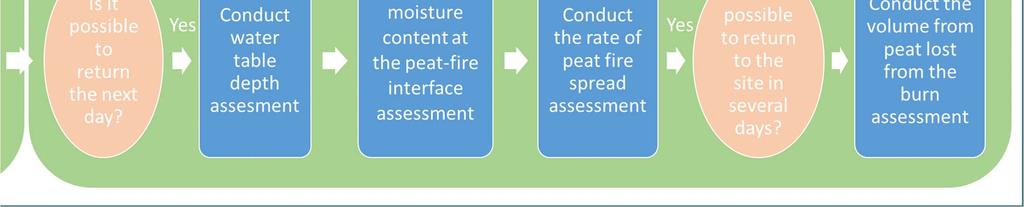
15 FSE Field activities


16 FSEs conducted Phase I of study ( ) 35 FSE were measured across 8 different village districts. Eighteen peat fires, all fuel volume measured. Range of forest and degradation types - land being prepared for palm oil development - rubber forest land - reforested land - land used for hunting and fishing - Land being prepared for agriculture - fires that spread into primary forest for the first time. Fires ranged from 0.5 to 200 ha in size on peat depths ranging from 0.5 to 8 m.
, Applied GeoSolutions (AGS), US -")
 - BRG, LAPAN, Directorate of Forest and Land Fire Control - MOEF (DFLFC) UPR")
17 Phase II: National scale - Four provinces, four field research sites - Riau, Jambi, Central Kalimantan, West Papua - Research partners: - SDSU and University of Montana (UMT), Applied GeoSolutions (AGS), US - IPB (National Coordinator) - BOSF - University of Palangka Raya (UPR), University of Riau (UR), WARSI, Papua University (UNIPA) - BRG, LAPAN, Directorate of Forest and Land Fire Control - MOEF (DFLFC) UPR DFLFC
 is housed within the database Facilitates export queries based on all combinations of the")
18 Data management A custom-designed Access database with user-interface and analysis capabilities has been developed for the project. All peat-fire and FSE data (and vegetation and hydrology data) is housed within the database Facilitates export queries based on all combinations of the environmental data, for both time and space.


19 Application of results Methods and data improve understanding and calculation of tropical peatland fire behaviour. These data can then be coupled to other components of this project, such as, the smoke analysis of burning peat, the generation of emission factors and emissions models for burning peatland landscapes, and to other projects and data-sets, such as providing calibration and verification tools for remotely-sensed peat volume loss techniques. These methods can now be applied elsewhere, providing a SOP for monitoring tropical peat fire on the ground. The new ACIAR-GoI tropical peatlands research project will adopt and apply these methods across two additional districts.
20 Terima kasih! We thank the Ministry of Forestry, Indonesia, in close cooperation with the Kapuas District Government and the Central Kalimantan Provincial Government We thank the BOSF field team from who have undertaken most of the data collection Pavla Graham who developed the Access database, and graphic designs for the project The research was funded by NASA
PEATLAND RESTORATION in Indonesia
 PEATLAND RESTORATION in Indonesia Dr. Myrna A. Safitri Deputy of Education, Socialization, Participation and Partnership Presentation at Japan Pavilion of COP 22, Marrakech November 11, 2016 Indonesian
Hotspot monitoring, fire investigation, and type and distribution of land assets in the KFCP area TECHNICAL RESEARCH PAPER
 TECHNICAL RESEARCH PAPER Hotspot monitoring, fire investigation, and type and distribution of land assets in the KFCP area Laura L.B. Graham, Febrasius Masal, Sherly Manjin, Elba Tri Juni, Fatkhurohman
CLICK TO EDIT MASTER TITLE STYLE
 CLICK TO EDIT MASTER TITLE STYLE Solutions Moving Ahead Creating a market to finance peatlands restoration in Kalimantan, Indonesia Dr. Alue Dohong Deputy Chief for Construction, Operation and Maintenance
This is a presentation on mangrove carbon stocks assessment.
 This is a presentation on mangrove carbon stocks assessment. 1 Mangroves are a unique tropical forest type. There are about 145,000 km of mangroves located throughout the tropical coastlines of the world.
REQUIRED DOCUMENT FROM HIRING UNIT
 Terms of reference GENERAL INFORMATION Title: Provincial Field Dinamisator Project Name : Support Facility for BRG (Badan Restorasi Gambut) Institutional Set-Up Reports to: Deputy III BRG Duty Station:
Dr Sue Page : Department of Geography TROPICAL PEATLAND FIRES
 Dr Sue Page : Department of Geography TROPICAL PEATLAND FIRES Tropical peatlands: Location & extent Tropical peatlands ~12% global area Approx. 70% (~26 M ha) occurs in SE Asia, mainly in Indonesia Natural
Faizal Parish and Chee Tong Yiew Global Environment Centre. Wetlands International Jill Heyde and Ed Wiken Wildlife Habitat Canada
 -UNFCCC COP10 Climate Change Kiosk 7 th December 2004 Buenos Aries Recent progress to address Peatland fires in SE Asia Faizal Parish and Chee Tong Yiew Global Environment Centre Nyoman Suryadiputra and
Standard Methods for Estimating Greenhouse Gas Emissions from Forests and Peatlands in Indonesia
 Standard Methods for Estimating Greenhouse Gas Emissions from Forests and Peatlands in Indonesia (Version 2) Chapter 4: Standard Method Forest Management Events and Regimes MINISTRY OF ENVIRONMENT AND
DIRECTORATE GENERAL OF CLIMATE CHANGE THE MINISTRY OF ENVIRONMENT AND FORESTRY
 HOW LAND AND FOREST FIRES SHOULD FIT INTO FOREST REFERENCE EMISSION LEVEL (FREL) DIRECTORATE GENERAL OF CLIMATE CHANGE THE MINISTRY OF ENVIRONMENT AND FORESTRY HOW LAND AND FOREST FIRES SHOULD FIT INTO
Fahmuddin Agus Indonesian Soil Research Institute Jl. Tentara Pelajar, No. 12, Cimanggu, Bogor 16114, Indonesia
 Fahmuddin Agus Indonesian Soil Research Institute Jl. Tentara Pelajar, No. 12, Cimanggu, Bogor 16114, Indonesia f_agus@litbang.pertanian.go.id MARCO Symposium 2015 Tsukuba International Congress Center,
In this presentation we are going to talk about monitoring, measuring and the quantification of carbon stocks in tropical peatland forests.
 In this presentation we are going to talk about monitoring, measuring and the quantification of carbon stocks in tropical peatland forests. 1 By way of introduction, we will see why we care about peatlands,
Budi Indra Setiawan. Bogor Agricultural University Indonesia
 Budi Indra Setiawan Bogor Agricultural University Indonesia 1 BACKGROUND CONCEPT OF SELARAS PRINCIPLE FOR BIOMASS PRODUCTION SELARAS PRINCIPLE FOR ACACIA PLANTATION IN PEATLANDS WATER MANAGEMENT IMPROVEMENT
Peatland degradation fuels climate change
 Peatland degradation fuels climate change Peatland degradation fuels climate change An unrecognised and alarming source of greenhouse gases November 2006. Government representatives from almost all countries
Vegetation Monitoring Methodology
 TECHNICAL PAPER Vegetation Monitoring Methodology Kalimantan Forests and Climate Partnership (KFCP) Laura Graham and Abdi Mahyudi TECHNICAL PAPER Vegetation Monitoring Methodology Kalimantan Forests and
Advancing Indonesian Forest Resource Monitoring Linking the approach from Global to National: Indonesia s experience. Belinda Arunarwati Margono
 Advancing Indonesian Forest Resource Monitoring Linking the approach from Global to National: Indonesia s experience Belinda Arunarwati Margono Outline The context Indonesia NFMS: how it was developed,
INDONESIAN INITIATIVES ON REDD+
 INDONESIAN INITIATIVES ON REDD+ by: A.F.Masud Ministry of Forestry Republic of Indonesia Forest Tenure and Regulatory Reforms, Beijing, September 2010 OUTLINE Introduction Forestry Role in Indonesia: Forest
The Indonesian-Norway cooperation on REDD+ (Slow, Halt & Reverse deforestation) World Bank, Washington DC, January 19, 2011 Fred Stolle People and
 World Bank, Washington DC, January 19, 2011 Fred Stolle People and") The Indonesian-Norway cooperation on REDD+ (Slow, Halt & Reverse deforestation) World Bank, Washington DC, January 19, 2011 Fred Stolle People and Ecosystem Program WRI Main Messages Future of Indonesian
The Indonesian-Norway cooperation on REDD+ (Slow, Halt & Reverse deforestation) World Bank, Washington DC, January 19, 2011 Fred Stolle People and Ecosystem Program WRI Main Messages Future of Indonesian
Sentinel Asia Wild Fire Control Initiative
 Sentinel Asia Wild Fire Control Initiative JPTM Step2 No.3 July 6-8 Manila Philippine Toshihisa HONMA (Hokkaido Univ.) for Masami FUKUDA (Univ. of Fukuyama) Objective of Sentinel Asia Wildfire Monitoring
Fire Occurrence in Borneo s Peatlands Between 1997 and 2005 and it s Impacts
 Workshop on Vulnerability of Carbon Pools of Tropical Peatlands in Asia Pekanbaru, Riau, Sumatra, Indonesia 24-26 January 2006 Fire Occurrence in Borneo s Peatlands Between 1997 and 2005 and it s Impacts
Atmospheric CH 4 and CO 2 enhancements and biomass burning emission ratios derived from satellite observations of the 2015 Indonesian fire plumes
 Atmospheric CH 4 and CO 2 enhancements and biomass burning emission ratios derived from satellite observations of the 2015 Indonesian fire plumes Robert Parker 1,3, Hartmut Boesch 1,3, Martin Wooster 2,3,
Development of Sub National FREL in West Kalimantan
 Development of Sub National FREL in West Kalimantan Hideyuki Kubo JICA Expert Indonesia Japan Project for Development of REDD+ Implementation Mechanism (IJ REDD+) 10 November 2016 Presentation 1. West
Fire Modelling in JULES using SPITFIRE: Spread and Intensity of Fires and Emissions Model
 Fire Modelling in JULES using SPITFIRE: Spread and Intensity of Fires and Emissions Model Allan Spessa National Centre for Atmosphere Science Department of Meteorology Reading University JULES Summer 2009
PROJECT INFORMATION DOCUMENT (PID) IDENTIFICATION/CONCEPT STAGE Report No.: PIDC103763
 IDENTIFICATION/CONCEPT STAGE Report No.: PIDC103763") PROJECT INFORMA DOCUMENT (PID) IDENTIFICA/CONCEPT STAGE Report No: PIDC103763 Project Name Region Country Financing Instrument Project ID Borrower Name Implementing Agency Environmental Category Date PID
PROJECT INFORMA DOCUMENT (PID) IDENTIFICA/CONCEPT STAGE Report No: PIDC103763 Project Name Region Country Financing Instrument Project ID Borrower Name Implementing Agency Environmental Category Date PID
REQUIRED DOCUMENT FROM HIRING UNIT
 Terms of reference GENERAL INFORMATION Title: Provincial Field Dinamisator (Jambi) Project Name: Support Facility for BRG (Badan Restorasi Gambut) Institutional Set-Up Reports to: Deputy III of BRG and
Report on Fire Danger Rating System (FDRS)
") Report on Fire Danger Rating System (FDRS) Orbita Roswintiarti, PhD. Indonesian National Institute of Aeronautics and Space (LAPAN) Presented at the Sentinel Asia Joint Project Team Meeting 2010 Manila,
Report on Fire Danger Rating System (FDRS) Orbita Roswintiarti, PhD. Indonesian National Institute of Aeronautics and Space (LAPAN) Presented at the Sentinel Asia Joint Project Team Meeting 2010 Manila,
Drivers, Pressures, Impacts, Response Analysis Of Peatland Fire In Sumatra, Indonesia
 Drivers, Pressures, Impacts, Response Analysis Of Peatland Fire In Sumatra, Indonesia Hesti L. Tata, Budi H. Narendra, Kirsfianti L. Ginoga Forest Research & Development Centre Forest & Environment Research
Available online at ScienceDirect. Procedia Environmental Sciences 33 (2016 ) Suria Darma Tarigan*
 Suria Darma Tarigan*") Available online at www.sciencedirect.com ScienceDirect Procedia Environmental Sciences 33 (2016 ) 386 392 The 2 nd International Symposium on LAPAN-IPB Satellite for Food Security and Environmental Monitoring
Available online at www.sciencedirect.com ScienceDirect Procedia Environmental Sciences 33 (2016 ) 386 392 The 2 nd International Symposium on LAPAN-IPB Satellite for Food Security and Environmental Monitoring
Implementing APRIL s 4Cs on Peatland
 Implementing APRIL s 4Cs on Peatland APRIL-IPEWG Peatland Roadmap Version 3.2, June 2017 The Independent Peatland Expert Working Group (IPEWG) was established to support APRIL by providing science-based
KFCP Heavy Fuel Load Assessment
 SCIENTIFIC REPORT KFCP Heavy Fuel Load Assessment Line Intersect Method and Heavy Fuel Load Results Laura Graham, Sherly Manjin, Elba Tri Juni, Matt Waldram, Febrasius Massal, Nasrul Ichsan, Fatkhurohman
Outline. Background and objective 24/11/2014. Land Cover Change Analysis for Supporting Indonesia s National Carbon Accounting System (INCAS)
") Land Cover Change Analysis for Supporting Indonesia s National Carbon Accounting System (INCAS) 1 2 3 4 Outline Background and objective Method Results The product Tatik Kartika, Kustiyo, Orbita Roswintiarti,
Land Cover Change Analysis for Supporting Indonesia s National Carbon Accounting System (INCAS) 1 2 3 4 Outline Background and objective Method Results The product Tatik Kartika, Kustiyo, Orbita Roswintiarti,
The Tropical Peatland Fire Dynamic. Sue Page, University of Leicester
 The Tropical Peatland Fire Dynamic Sue Page, University of Leicester sep5@le.ac.uk Learning from the tropical peat fire experience What have we learnt? Peat fires massive emissions Peat fires significant
Indonesia: New Opportunities for Climate Compatible Agriculture. KEMEN AUSTIN Research Analyst
 Indonesia: New Opportunities for Climate Compatible Agriculture KEMEN AUSTIN Research Analyst Background GHG emissions profile GHG emissions from land cover change comprise 10-15% of global GHG emissions
Fundamental of Peatland Mapping Consultation Meeting for Indonesian Climate Change Center (ICCC)
") Fundamental of Peatland Mapping Consultation Meeting for Indonesian Climate Change Center (ICCC) DNPI, 15th August 2011 Mitsuru Osaki Research Faculty of Agriculture, Hokkaido University Kazuyo Hirose
Fundamental of Peatland Mapping Consultation Meeting for Indonesian Climate Change Center (ICCC) DNPI, 15th August 2011 Mitsuru Osaki Research Faculty of Agriculture, Hokkaido University Kazuyo Hirose
REQUIRED DOCUMENT FROM HIRING UNIT
 Terms of reference GENERAL INFORMATION Title: Provincial Field Dinamisator (Jambi) Project Name: Support Facility for BRG (Badan Restorasi Gambut) Institutional Set-Up Reports to: Deputy III of BRG Duty
KFCP Vegetation Monitoring, Fire Management Monitoring, and Peat and Hydrology Monitoring
 ii KFCP Vegetation Monitoring, Fire Management Monitoring, and Peat and Hydrology Monitoring PRACTICAL LESSONS LEARNED Vegetation Monitoring, Fire Management Monitoring, and Peat and Hydrology Monitoring
Vegetation Monitoring, Fire Management Monitoring, and Peat and Hydrology Monitoring
 PRACTICAL LESSONS LEARNED Vegetation Monitoring, Fire Management Monitoring, and Peat and Hydrology Monitoring Kalimantan Forests and Climate Partnership (KFCP) January 2014 Vegetation Monitoring, Fire
15 th International Peat Congress in Sarawak, Malaysia Is Peatland Utilization the Main Cause of Land Fire in Indonesia?.
 15 th International Peat Congress in Sarawak, Malaysia www.ipc2016.com Is Peatland Utilization the Main Cause of Land Fire in Indonesia?. Moch. Riza Kasfari*), Yudha Asmara Adhi, Basuki Somawinata and
REQUIRED DOCUMENT FROM HIRING UNIT
 Terms of reference GENERAL INFORMATION Title: Field Dinamisator Consultant for Riau Province Project Name: Support Facility for BRG Institutional Set-Up Reports to: Deputy III Peatland Restoration Agency
Major atmospheric emissions from peat fires in SEA during non-drought years: Evidence from the 2013 Sumatran fires David Gaveau
 SOCP/YEL Paul Hilton/SOCP/YEL Reuters Major atmospheric emissions from peat fires in SEA during non-drought years: Evidence from the 2013 Sumatran fires David Gaveau Salim MA, Hergoualc h K, Locatelli
 67 別添資料 1 69 別添資料 1 71 別添資料 1 72 73 別添資料 1 74 75 別添資料 1 77 別添資料 1 78 79 別添資料 1 80 81 別添資料 1 82 83 別添資料 1 84 85 別添資料 1 86 87 別添資料 1 88 89 別添資料 1 90 91 別添資料 1 92 93 別添資料 1 94 95 別添資料 1 96 97 別添資料 1 98
Biochar Carbon Sequestration
 Biochar Carbon Sequestration In Tropical Land Use Systems Christoph Steiner Laurens Rademakers Winfried E. H. Blum Greenhouse gas emissions Biofuels fossil fuel substitution Holly K Gibbs et al 2008 Environ.
Standard Methods for Estimating Greenhouse Gas Emissions from Forests and Peatlands in Indonesia
 Standard Methods for Estimating Greenhouse Gas Emissions from Forests and Peatlands in Indonesia (Version 2) Chapter 8: Standard Method Data Integration and Reporting MINISTRY OF ENVIRONMENT AND FORESTRY
Understanding the Role of Fire in Forest Management
 Understanding the Role of Fire in Forest Management O NLY YOU can prevent forest fires, says Smokey Bear. In the 1950s, 60s, and 70s, it was a common refrain. In time, the concept that all forests fires
Fire in Dry Eucalypt Forest:
 Project Vesta Fire in Dry Eucalypt Forest: fuel structure, fuel dynamics and fire behaviour. Project Vesta is Australia s most recent and significant study of forest fire behaviour. This comprehensive
Fire & Characteristics of Wildfire
 Fire & Characteristics of Wildfire Curriculum Links: Grade 7 Physical Science--Heat and Temperature (HT) Objectives In this lesson students will develop an operational definition of wildfires. They will
REDD+ Phases 30/03/2010. Phase 1. Phase 2. Phase 3
 REDD+ Phases Phase 1 National REDD strategy development Establish policies and measures for MRV emission reduction from the forestry sector Develop an initial i i institution i i and identify if necessary
Additional Data File 2.
 Additional Data File 2. Summary of projects, programs and policy initiatives under the Reducing Emissions from Deforestation and forest Degradation (REDD) framework taking place in (or with a policy focus
INDONESIA: UN-REDD PROGRESS Jakarta, September 14, 2009
 INDONESIA: UN-REDD PROGRESS 2009 DIRECTORATE GENERAL OF FOREST PLANNING MINISTRY OF FORESTRY Jakarta, September 14, 2009 PROGRESS National Climate Change Council Forestry Climate Change Working Group Demonstration
Riau province in Sumatra has one of the most significant peatland carbon stores anywhere in the world.
 22 riau: A LIT FUSE 23 PALM OIL CONCESSIONS ON PEAT Riau province in Sumatra has one of the most significant peatland carbon stores anywhere in the world. The peat forests in Riau account for just over
Wahyunto, Ai Dariah and Fahmuddin Agus. Soil Research Institute INDONESIAN MINISTRY OF AGRICULTURE
 DISTRIBUTION, PROPERTIES, AND CARBON STOCK OF INDONESIAN PEATLAND Wahyunto, Ai Dariah and Fahmuddin Agus Wahyunto_wt@yahoo.co.id Center for Agricultural Land Resources Research and Development Center for
A Review of Three Tiers of Forest and Peatland Fire Monitoring in Tropical Indonesia: Space, Atmosphere, and Surface
 Metro Manila - Philippines, 28 May 2018 A Review of Three Tiers of Forest and Peatland Fire Monitoring in Tropical Indonesia: Space, Atmosphere, and Surface Nina Yulianti 123 1 Graduate Program of Environmental
Forest Fire Case Study (ID) DMCC Working Group, APAN44th, Hongkong Basuki Suhardiman
 DMCC Working Group, APAN44th, Hongkong Basuki Suhardiman") Forest Fire Case Study (ID) DMCC Working Group, APAN44th, Hongkong 2017 Basuki Suhardiman basuki@itb.ac.id Firewatch in Forestry Iniatiatited by Ministry of Forestry in the early 2001 In 2009 collaboration
Forest Fire Case Study (ID) DMCC Working Group, APAN44th, Hongkong 2017 Basuki Suhardiman basuki@itb.ac.id Firewatch in Forestry Iniatiatited by Ministry of Forestry in the early 2001 In 2009 collaboration
INDONESIAN MORATORIUM IMPACT. DR Rosediana Suharto Indonesian Palm Oil Commission
 INDONESIAN MORATORIUM IMPACT DR Rosediana Suharto Indonesian Palm Oil Commission LOI Indonesia Norway Phase 1. Preparation Completing a national REDD+ strategy also addressing all key drivers of forest
LAND-FOREST FIRE MANAGEMENT INDONESIA AND CLIMATE CHANGE IN. Israr Albar Directorate General of Climate Change Ministry of Environment and Forestry
 LAND-FOREST FIRE MANAGEMENT AND CLIMATE CHANGE IN INDONESIA Israr Albar Directorate General of Climate Change Ministry of Environment and Forestry Forum of National Bioethics Committees (NBCs) on Transboundary
MORATORIUM FIRE AND LOGGING INCREASE ABOVE GROUND CARBON STOCK: A CASE STUDY IN BURNT PEAT AREA OF EX-MEGA RICE PROJECT, CENTRAL KALIMANTAN, INDONESIA
 MORATORIUM FIRE AND LOGGING INCREASE ABOVE GROUND CARBON STOCK: A CASE STUDY IN BURNT PEAT AREA OF EX-MEGA RICE PROJECT, CENTRAL KALIMANTAN, INDONESIA Bambang Hero Saharjo Forest Fire Laboratory, Division
Remotely-Sensed Fire Danger Rating System to Support Forest/Land Fire Management in Indonesia
 Remotely-Sensed Fire Danger Rating System to Support Forest/Land Fire Management in Indonesia Orbita Roswintiarti Indonesian National Institute of Aeronautics and Space (LAPAN) SE Asia Regional Research
Costs and benefits of peat development options
 Costs and benefits of peat development options Prof. Dr Lars Hein; Dr. Elham Sumarga (ITB); Saritha Uda, MSc; Aritta Suwarno MSc Wageningen University, the Netherlands Introduction to the research group
Session 1 implementation. We construct our national FREL with the following principles: transparency, accuracy, completeness, consistency, and compara
 FREL and REDD+ in Indonesia Novia Widyaningtyas (Ministry of Environment and Forestry, Indonesia) Session 1 FREL and REDD+ in Indonesia Novia Widyaningtyas (Ministry of Environment and Forestry, Indonesia)
FREL and REDD+ in Indonesia
 FREL and REDD+ in Indonesia Ms. Novia Widyaningtyas Head of REDD+ Division Directorate of Climate Change Mitigation Directorate General of Climate Change Ministry of Environment and Forestry - Republic
Video 1. From any other page, click the button above to return to this Contents page
 FIREFIGHTER SAFETY SERIES FIRE BEHAVIOR IN THE WILDLAND/URBAN INTERFACE Sponsored by Wildland/Urban Interface Working Team USDA Forest Service US Department of the Interior Bureau of Indian Affairs Bureau
S-190 Introduction to Wildland Fire Behavior
 S-190 Introduction to Wildland Fire Behavior Why we feel fire behavior training is critical COURSE OBJECTIVES Identify and discuss the three sides of the fire triangle. Ë Identify the environmental factors
Indonesia Burning The Impact of Fire on Tropical Peatlands : Focus on Central Kalimantan
 Indonesia Burning The Impact of Fire on Tropical Peatlands : Focus on Central Kalimantan A collaborative research programme: *Sue Page, Univ. of Leicester, UK *Jack Rieley, Univ. of Nottingham, UK *Florian
Knowledge Objectives (3 of 3)
") Wildfire Investigations Knowledge Objectives (1 of 3) Describe the difference among ground fuels, surface fuels, and aerial fuels and their effects on fire spread. Describe the effects of wind, fuels,
Wildfire Investigations Knowledge Objectives (1 of 3) Describe the difference among ground fuels, surface fuels, and aerial fuels and their effects on fire spread. Describe the effects of wind, fuels,
Curriculum Development on the Management of Tropical Peatland Market Survey
 New Educational Tools for sustainable Management of Peatlands in the Humid Tropics/ PEATWISE Curriculum Development on the Management of Tropical Peatland Market Survey University of Malaysia, Sarawak,
Land vested in Her Majesty in the right of Ontario.
 Many of the terms listed are found in the 2000 Glossary of Forest Fire Management Terms (Canadian Interagency Forest Fire Centre CIFFC) and the Forest Management Planning Manual (OMNR). Other terms included
Pilot ecosystem account for Indonesia peatlands in Sumatera and Kalimantan. Etjih Tasriah BPS-Statistics Indonesia
 Pilot ecosystem account for Indonesia peatlands in Sumatera and Kalimantan Etjih Tasriah BPS-Statistics Indonesia SEEA IMPLEMENTATION IN INDONESIA 1990 BPS started to compile SISNERLING 2012 SEEA-CF was
Southern Rural Fire. How To Safety Burn Stubble.
 Southern Rural Fire How To Safety Burn Stubble. Contents 1 Understanding the Risks... 3 2 Fire Environment and Fire Behaviour... 3 2.1 Topography... 4 2.2 Fuel... 5 2.3 Weather... 7 3 Fire Environment
REQUIRED DOCUMENT FROM HIRING UNIT
 Terms of reference GENERAL INFORMATION Title: Senior Specialist for Social Safeguard Development Project Name: Badan Restorasi Gambut (BRG) Support Facility Reports to: Deputy III of BRG Duty Station:
ASEAN TECHNICAL WORKSHOP ON DEVELOPMENT OF THE ASEAN PEATLAND FIRE PREDICTION AND EARLY WARNING SYSTEM. Group 1 Report
 ASEAN TECHNICAL WORKSHOP ON DEVELOPMENT OF THE ASEAN PEATLAND FIRE PREDICTION AND EARLY WARNING SYSTEM 20-21 March 2012 Sunway Putra Hotel, Kuala Lumpur, Malaysia Group 1 Report Is there a need for enhancement
ScienceDirect. Historical forest fire occurrence analysis in Jambi Province during the period of : its distribution & land cover trajectories
 Available online at www.sciencedirect.com ScienceDirect Procedia Environmental Sciences 33 (2016 ) 450 459 The 2 nd International Symposium on LAPAN-IPB Satellite for Food Security and Environmental Monitoring
Land use, spatial planning, and potential implications for REDD+ in Indonesia: A preliminary analysis
 Land use, spatial planning, and potential implications for REDD+ in Indonesia: A preliminary analysis Ida Aju Pradnja Resosudarmo Pekanbaru, May 11, 2012 Context-1: the Forest Area 187 MHa land area 93
Standard Methods for Estimating Greenhouse Gas Emissions from Forests and Peatlands in Indonesia
 Standard Methods for Estimating Greenhouse Gas Emissions from Forests and Peatlands in Indonesia (Version 2) Chapter 5: Standard Method Forest Cover Change MINISTRY OF ENVIRONMENT AND FORESTRY RESEARCH,
STUDY ON LAND-USE AND LAND COVER CHANGE (LUCC) AND GREEN HOUSE GAS (GHG) EMISSION
 AND GREEN HOUSE GAS (GHG) EMISSION") STUDY ON LAND-USE AND LAND COVER CHANGE (LUCC) AND GREEN HOUSE GAS (GHG) EMISSION Lilik B. PRASETYO*, Genya SAITO**, Haruo TSURUTA**, Shigeto SUDO**, Daniel MURDIYARSO*, Upik ROSALINA* * Bogor Agriculture
STUDY ON LAND-USE AND LAND COVER CHANGE (LUCC) AND GREEN HOUSE GAS (GHG) EMISSION Lilik B. PRASETYO*, Genya SAITO**, Haruo TSURUTA**, Shigeto SUDO**, Daniel MURDIYARSO*, Upik ROSALINA* * Bogor Agriculture
Improved Land Use Planning for economic growth and emission reduction
 Improved Land Use Planning for economic growth and emission reduction ANNUAL WORLD BANK CONFERENCE ON LAND AND POVERTY APRIL 18-20, 2011 WASHINGTON, DC Fred Stolle.. Agenda Problem definition Oil Palm
Trajectory and Concentration PM 10. on Forest and Vegetation Peat-Fire HYSPLIT Model Outputs and Observations (Period: September October 2015)
") IOP Conference Series: Earth and Environmental Science PAPER OPEN ACCESS Trajectory and Concentration PM 10 on Forest and Vegetation Peat-Fire HYSPLIT Model Outputs and Observations (Period: September
IOP Conference Series: Earth and Environmental Science PAPER OPEN ACCESS Trajectory and Concentration PM 10 on Forest and Vegetation Peat-Fire HYSPLIT Model Outputs and Observations (Period: September
Pontianak, October 1-2, 2013
 Workshop for Climate Change Mitigation Through the Cooperation between Ministry of Forestry, Provincial Government of West Kalimantan, and Japan International Cooperation Agency Pontianak, October 1-2,
REQUIRED DOCUMENT FROM HIRING UNIT
 Terms of reference GENERAL INFORMATION Title: Senior Specialist for BRG Support Facilities Project Name: Support Facility for BRG Institutional Set-Up Reports to: Technical Adviser for Natural Resources
Spatiotemporal distribution of peatland fires in Kapuas District, Central Kalimantan Province, Indonesia
 Agriculture, Forestry and Fisheries 2014; 3(3): 163-170 Published online May 30, 2014 (http://www.sciencepublishinggroup.com/j/aff) doi: 10.11648/j.aff.20140303.14 Spatiotemporal distribution of peatland
LANDSCAPE APPROACH MANAGEMENT. De-coupling Environmental Degradation from Sustainable Growth
 LANDSCAPE APPROACH MANAGEMENT De-coupling Environmental Degradation from Sustainable Growth 1 APP SUSTAINABILITY ROADMAP The Sustainability Roadmap Vision 2020, launched in 2012, is our strategy to place
HUMAN RESOURCES AND EDUCATIONAL INFRASTRUCTURE
 University of Palangka Raya HUMAN RESOURCES AND EDUCATIONAL INFRASTRUCTURE Human Resources The number of academic staff in UNPAR until 2003 is 640, consists of 399 undergraduates, 221 masters and 20 doctors.
Impact of Land Use Change on Carbon Stock and GHG Emissions in New Oil Palm Plantings - Case Studies from Musim Mas Group -
 Impact of Land Use Change on Carbon Stock and GHG Emissions in New Oil Palm Plantings - Case Studies from Musim Mas Group - By Dr Gan Lian Tiong, Musim Mas Group Head of Sustainability Introduction Over
First Resources Limited. Policy on Sustainable Palm Oil Progress Report
 First Resources Limited Policy on Sustainable Palm Oil Progress Report 1 July 2015 to 31 December 2015 First Resources Limited Sustainability Policy Progress Report 2 Introduction As a palm oil producer,
REQUIRED DOCUMENT FROM HIRING UNIT
 Terms of reference GENERAL INFORMATION Title: Senior Specialist for Environment Safeguard Development Project Name: Badan Restorasi Gambut (BRG) Support Facility Reports to: Deputy III of BRG Duty Station:
Fire in the Earth System
 Fire in the Earth System Allan Spessa Project Manager, QUEST Earth System Model, NCAS-Climate & Walker Institute, Reading University Priorities for a fire module in JULES Basic processes: Ignitions (human-caused/lightning),
H.E. Todung Mulya Lubis Ambassador to Norway. Republic of Indonesia
 H.E. Todung Mulya Lubis Ambassador to Norway Republic of Indonesia Indonesia s Palm Oil Diplomacy Engaging trading partners and stakeholders to achieve the SDGs in the vegetable oil sector H.E. MR. TODUNG
Summary of Terminal Evaluation
 I. Outline of the Project Country: Indonesia Issue/Sector: Environment and Energy Division in charge: Global Environment Dept. Forestry and Nature Conservation Division 1 Period of (R/D): Dec.2009 to Mar.
Risk Analysis and Impact Assessment for Pulp and Plantation Investments: The Case of Indonesia
 Risk Analysis and Impact Assessment for Pulp and Plantation Investments: The Case of Indonesia Christopher Barr Center for International Forestry Research (CIFOR) International Forum on Finance and Investment
Monitoring Deforestation and Forest Degradation on National and Local Level in Indonesia
 Monitoring Deforestation and Forest Degradation on National and Local Level in Indonesia Dr. Ir. Ruandha A. Sugardiman, M.Sc. Dr. Ir. Belinda A. Margono, M.Sc. Ministry of Environment and Forestry Indonesia
FORMA: Forest Monitoring for Action
 FORMA: Forest Monitoring for Action FORMA uses freely-available satellite data to generate rapidly-updated online maps of tropical forest clearing. We have designed it to provide useful information for
(R)EDD monitoring by WWF Indonesia WWF data contained in this presentation is not yet published, Please keep this for your eyes only.
EDD monitoring by WWF Indonesia WWF data contained in this presentation is not yet published, Please keep this for your eyes only.") (R)EDD monitoring by WWF Indonesia WWF data contained in this presentation is not yet published, Please keep this for your eyes only. ALOS K&C9 meeting, 24 January 2008 Yumiko Uryu Consultant to WWF yumuryu@yahoo.com
(R)EDD monitoring by WWF Indonesia WWF data contained in this presentation is not yet published, Please keep this for your eyes only. ALOS K&C9 meeting, 24 January 2008 Yumiko Uryu Consultant to WWF yumuryu@yahoo.com
"Project Formulation Survey" under the Governmental Commission on the Projects for ODA Overseas Economic Cooperation in FY2013.
 "Project Formulation Survey" under the Governmental Commission on the Projects for ODA Overseas Economic Cooperation in FY2013 Summary Report Republic of Indonesia Project Formulation Survey for dissemination
THE ROLE OF PUBLIC-PRIVATE COOPERATION FOR THE CONSERVATION AND RESTORATION OF FOREST ECOSYSTEM
 THE ROLE OF PUBLIC-PRIVATE COOPERATION FOR THE CONSERVATION AND RESTORATION OF FOREST ECOSYSTEM by: HERRY SUBAGIADI Director of Conservation Area, Ministry of Environment and Forestry, RI. INDONESIAN FORESTS
New wildfire terms for 2017
 2017.06.27 New wildfire terms for 2017 INSIDE THIS ISSUE Stages of Control 1 Northwest Update 2 Crew Activities 3 Weather Maps 4 Weather Indices 5 FireSmart 6 Restrictions and Contacts 6 NWFC NUMBERS Since
The Ecological Characteristics of Peatland Ecosystem in Giam Siak Kecil Bukit Batu Biosphere Reserve, in Riau Province, Sumatra, Indonesia.
 The Ecological Characteristics of Peatland Ecosystem in Giam Siak Kecil Bukit Batu Biosphere Reserve, in Riau Province, Sumatra, Indonesia. Year: 2009 Location of field work: Riau Province, Sumatra, Indonesia
Indonesia. Landscape Factsheet
 Indonesia Landscape Factsheet In Indonesia, through an integrated approach, we drive sustainable commodity production, livelihood improvement and forest conservation in several landscapes. In Aceh, our
ESCONDIDO FIRE DEPT TRAINING MANUAL Section Engine Module Page 1 of 6 Wildland Hand Crews Revised
 Engine Module Page 1 of 6 HANDCREW OPERATIONS Hand crews play an important role in wildland fire suppression. Each crew is made up of highly skilled individuals using a variety of hand tools that match
SUMMARY. Pulang Pisau GREEN GROWTH STRATEGY. Green growth sectors
 Central Kalimantan, Indonesia Published in May 2015 SUMMARY STRATEGY District overview district is located in the southeast of Central Kalimantan province, which sits in the southern quadrant of the island
1.2 If we cannot define it, we cannot save it
 1.2 If we cannot define it, we cannot save it Meine van Noordwijk and Peter Akon Minang Introduction In the discussions on reducing emissions from forests and other aspects of land use, the negotiators
What has been learned from first year of Golden Agri s forest conservation policy in West Kalimantan?
 www.greenomics.org 24 May 2012 What has been learned from first year of Golden Agri s forest conservation policy in West Kalimantan? Appears that concrete efforts are being made to conserve secondary swamp
Estimating the Variability of Greenhouse Gas Footprints of Crude Palm Oil production in Indonesia
 Estimating the Variability of Greenhouse Gas Footprints of Crude Palm Oil production in Indonesia Wan Yee Lam 67 th Swiss LCA Discussion Forum Sources of Variability Forest edge carbon degradation Peat