A global perspective on land use and cover change
|
|
|
- Joshua McCoy
- 6 years ago
- Views:
Transcription
")
1 A global perspective on land use and cover change Alan Belward The Global Environment Monitoring Unit Institute for Environment and Sustainability European Commission Joint Research Centre Ispra (VA) Italy
2 Hourly


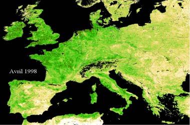
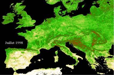
3 Alan Belward Ispra 22 Feb,, 22 Apr., 22 Jul.22 Oct Nadine Gobron, fapar Images Daily and seasonally


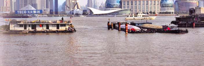
4 Michael Glantz NCAR Annually and inter-annually Shanghai, China 1987 Shanghai, China 2004 Porto Velho, Brazil 1908 Porto Velho, Brazil
5 Source IPCC TAR, 2001 Land surface / atmosphere interactions

6 New demands for land cover land use information Forcing Inventory Variability & Uncertainty Attribution of Causes Up and downscaling Predictions and Scenarios Resource availability Resource quality Verification & planning Preservation & Conservation Figure IPCC AR4 2007
7 Using seasonal attributes In 1990 the IGBP identified major limitations to existing global land cover data sets The first global 1 km resolution AVHRR data set was begun in April 1992 The first 1 km land cover map, IGBP s DISCover, was released in 1997 GLC 2000 began in 1999 and was released in 2005 MODLAND began in 2001 the 500 m product was released in December 2008 GLOBCOVER 300 m began in 2004, V1.0 was released in 2007

8 Seasonal tracking no longer relies on Met. Satellites 23 rd June 1981 NOAA-7 21 st April 1995 ERS-2 ATSR-2 1 st August 1997 SeaWifs 24 th March 1998 VGT on SPOT-4 18 th December 1999 Terra s MODIS & MISR 1 st March 2002 ENVISAT MERIS 4 th May 2002 Aqua MODIS 14 th December 2002 GLI & POLDER on ADEOS VGT3 and Sentinel 2 and 3 National Land Imaging Program s LDCM

9 Overall accuracy 68.6%

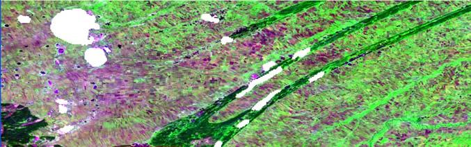
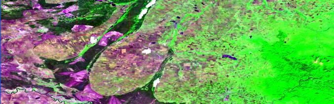
10 GlobCover V2.2 October 2008 Overall accuracy 73.14%


11 Frederic Achard GLC Eurasia GlobCover


12 Frederic Achard GlobCover MERIS Mosaic VGT Mosaic (GLC 2000)


13 Frederic Achard Croplands Cropland / grassland complexes Steppe Cultivated and Managed areas Mosaic cropland / vegetation Mosaic vegetation / cropland Sparse vegetation GLC 2000 Evergreen needle-leaved forest Deciduous broadleaved forest Closed to open broadleaved evergreen and/or semi-deciduous forest Closed broadleaved deciduous forest Closed needle-leaved evergreen forest Closed to open mixed broadleaved & needleaved forest GlobCover

14 Olivier Arino ESA

15 Hugh Eva, Pierre Defourney 1 km 300 m Google Copyright Google
16 Asia


 and")
17 Indonesia: Central Sumatra - Riau province Window size: 190 x 275 km Images MODIS (2004) and ALOS (2007)

18 Multi-annual change White Nile Irrigation Scheme pre expansion 1975 And after construction 2000 (images Landsat) Source Hugh Eva Andreas Brink 50,000 km2 of natural vegetation converted to agriculture every year since the 1970s km

19 REDD; An International undertaking GOFC GOLD coordination Report prepared by: DeFries, Achard, Brown, Herold, Murdiyarso, Schlamadinger, De Souza, GTOS Report 46, 23 p Available at: html
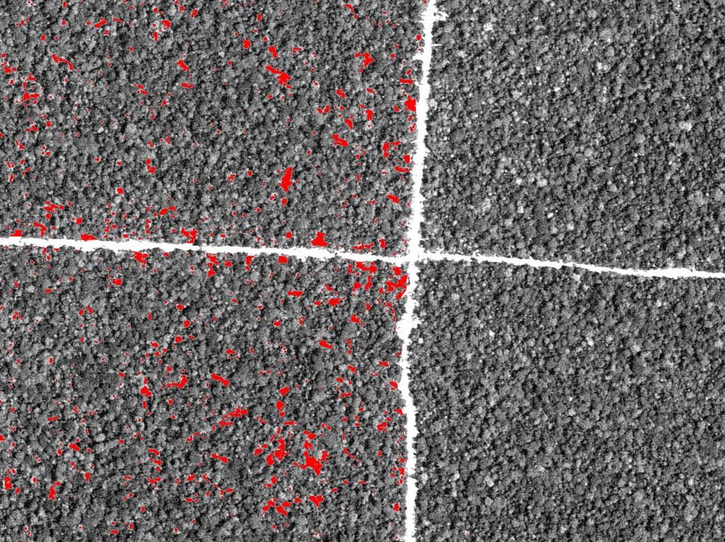
20 Gross carbon emissions Gross carbon emissions Gross deforestation Gross degradation C gr m + = A loss C ( i ) loss ( i ) i= 1 n j= 1 C _ em dgr ( j ) dgr ( j ) A Aloss = Area of deforestation (ha) Closs = Carbon emission from deforestation (t/ha) Adgr = Area affected by degradation (ha) Cdgr = Carbon emission from degradation (t/ha) for forest types i m for degrad. types j n Area change is most dynamic: can be observed from satellite


 1990")
21 Setting a deforestation rate benchmark Future emissions will need to be compared to a national reference emission scenario Such a scenario will be based on historical deforestation and degradation rates (at country level)


 annual Hot spots of")


 Regionally-tuned forest")
22 Monitoring gross changes in forest area Global observations Hot spot/large deforestation detection MODIS-type sensors Deforestation (~10-20 ha) (intra-) annual Hot spots of forest change National/local observations Wall-to-wall mapping Sampling approach Landsat-type sensors Deforestation (~0.5-1 ha) inter- annual (5 10 years) Regionally-tuned forest degradation mapping Change in forest area and density
 from IPCC")
23 Uncertainty Land to atmosphere emissions from land use changes during the 80s and 90s (GtC yr 1) from IPCC AR4
24 FAO FRA 2010 Remote Sensing Survey ystematic sample grid to estimate forest cover changes between 1990, 2000 & Samples are 20km x 20km size

25 MSG 6 th March 2004 (Source copyright EUMETSAT)

26 350 km 2,400 km Background image VGT 2000 Mosaic (image source JRC, data source CNES )
 35")
27 Background image MODIS 10 th January 2005 (source NASA ) 35 km

28 3.5 km Background image SPOT HRV 10 m March 2005 (image source JRC, data source CNES )

29 January month before logging

30 March month after logging
31

32 January months after logging


33 REDD; a driver of land cover change services Global emissions from transport: 5 Gt CO2 eq/yr Emissions from EU-27: 5.2 Gt CO2 eq/yr Emissions from tropical deforestation: 5.9 Gt CO2 eq/yr Since 1990 the EU has decreased emissions by c.a. 0.4 Gt CO2 eq/yr
34 Commitment and progress
35 Commitment and progress GCOS Actions 22.Establish international standards and specifications for the production of land-cover characterization maps 23.Produce reliable accepted methods for land-cover map accuracy assessment 24.Commit to continuous 10-30m resolution optical satellite systems with data acquisition strategies at least equivalent to the Landsat 7 mission for land cover 25.Develop an in situ reference network and apply CEOS WGCV validation protocols for land cover 26.Generate annual products documenting global landcover characteristics at resolutions between 250m and 1km, according to internationally-agreed standards and accompanied by statistical descriptions of the maps accuracy 27.Generate maps documenting global land cover at resolutions between 10m and 30m every 5 years, according to internationally-agreed standards and accompanied by statistical descriptions of the maps accuracy

36 Emerging standards for legend definition (T22)


37 Emerging standards for validation (T23)

38 LDCM, Sentinel 2 (T24)
39 MODLAND, GlobCover T26
40 User Reported Primary Use of Landsat (Since Oct 1 st 2008*) *200,000 scenes downloaded OTHER 1.1% CRYOSPHERE 1.6% VISUALIZATION 3.6% WATER 3.0% NATURAL RESOURCES 3.8% TELECOMMUNICATIONS 0.3% TERR MONITORING 0.8% PLANNING 1.3% FIRE 0.5% ENERGY 1.0% Primary Data Usages HUMAN ECOLOGY 0.3% EMERGENCY RESPONSE 0.2% HUMAN HEALTH 0.2% INTERNATIONAL LAND ISSUES NATIONAL SECURITY 0.1% 0.1% SOCIOECONOMICS 0.0% AGRICULTURE 25.9% CLIMATE CHANGE 4.8% FORESTRY 5.2% ECOSYSTEM 5.7% GEOLOGY 6.0% EDUCATION 25.4% LAND CHANGE 9.3% Source Kristi Kline, Landsat Project Manager
41 User Reported Other Use of Landsat (Since Oct 1st 2008*) *200,000 scenes downloaded VISUALIZATION ENERGY 2.6% 2.8% HUMAN ECOLOGY 3.2% TERR MONITORING 4.3% Data Usages NATIONAL SECURITY 0.9% HUMAN HEALTH CRYOSPHERE 0.8% 1.0% INTERNATIONAL LAND ISSUES 1.8% PLANNING 2.4% INSURANCE 0.7% SOCIOECONOMICS 0.6% TELECOMMUNICATIONS 0.5% OTHER 0.3% AGRICULTURE 11.4% EDUCATION 9.1% EMERGENCY RESPONSE 4.7% LAND CHANGE 8.9% GEOLOGY 4.9% NATURAL RESOURCES 5.7% WATER 7.7% FIRE 5.8% ECOSYSTEM 6.4% CLIMATE CHANGE 6.6% FORESTRY 6.8% Source Kristi Kline, Landsat Project Manager

42 High resolution (T27)
43 Seasonal attributes 25 km Spring Cereals Legumes Winter Cereals Oilseed Rape Alan Belward Landsat MSS February, April, May, August 1983
 Considerable progress in global land cover mapping is being made, less in cover change, even less in land use One map won t serve all users Restricts use to specific modelling communities")

44 Conclusions Malpensa Airport, as seen by US satellites 29 th August 1963, 9 th October 2006 Declassified KH series military (1963), Landsat (2006) Sputnik launch October 4th 1957 (history.nasa.gov) Considerable progress in global land cover mapping is being made, less in cover change, even less in land use One map won t serve all users Restricts use to specific modelling communities Compromises regional and national relevance Limited value for resource planning and management Lacks flexibility as a source of reference data for multiple environmental conventions New biophysical products negate the need for more of the same in global land cover mapping Suitable sensors must be matched by suitable data acquisition strategies, which is not always the case Annual global scale monitoring at high spatial resolution is the new priority Once every 5 years is unlikely to be enough
Background. Chapter (DeFries et al.) in IPAM/ED book (eds: Moutinho + Schwartzman)
 in IPAM/ED book (eds: Moutinho + Schwartzman)") Global Observation of Forest and Land Cover Dynamics Monitoring Deforestation for Compensated Reductions Martin Herold ESA GOFC-GOLD Land Cover Project Office FSU Jena, Germany on behalf of GTOS/GOFC-GOLD
Global Observation of Forest and Land Cover Dynamics Monitoring Deforestation for Compensated Reductions Martin Herold ESA GOFC-GOLD Land Cover Project Office FSU Jena, Germany on behalf of GTOS/GOFC-GOLD
Forest and Land Cover Monitoring by Remote Sensing Data Analysis
 Low Carbon Asia Research Network (LoCARNet) 3rd Annual Meeting Bogor, Indonesia November 24 26, 2014 Forest and Land Cover Monitoring by Remote Sensing Data Analysis Muhammad Ardiansyah Center for Climate
The geospatial domain: new ways of addressing the Millennium Development Goals
 Earth Observation for Africa, with Africa; AAAS Boston 14 th 18 th February 2008 1 Joint Research Centre (JRC) The European Commission s Research-Based Policy Support Organisation The geospatial domain:
Mapping the world s forests: work by FAO and partners in the global Forest Resource Assessment (FRA) Mette L. Wilkie Adam Gerrand FAO
 Mette L. Wilkie Adam Gerrand FAO") Mapping the world s forests: work by FAO and partners in the global Forest Resource Assessment (FRA) Mette L. Wilkie Adam Gerrand FAO www.fao.org/forestry/fra2010 Main points Challenges unprecedented global
Mapping the world s forests: work by FAO and partners in the global Forest Resource Assessment (FRA) Mette L. Wilkie Adam Gerrand FAO www.fao.org/forestry/fra2010 Main points Challenges unprecedented global
Examples of the use of MERIS data in marine and land applications
 Examples of the use of MERIS data in marine and land applications Peter Regner Science, Applications & Future Technologies Department ESA/ESRIN, Frascati, Italy Examples of the use of MERIS data European
Module 2.1 Monitoring activity data for forests using remote sensing
 Module 2.1 Monitoring activity data for forests using remote sensing Module developers: Frédéric Achard, European Commission (EC) Joint Research Centre (JRC) Jukka Miettinen, EC JRC Brice Mora, Wageningen
Role and importance of Satellite data in the implementation of the COMIFAC Convergence Plan
 Plenary Meeting of the Congo Basin Forest Partnership (CBFP) Palais des Congrès, Yaoundé. Cameroon 11-12 November, 2009 Role and importance of Satellite data in the implementation of the COMIFAC Convergence
Crop Monitoring for Food Security from Space
 San Diego, 18-22 February 2010 AAAS Annual Meeting 1 Crop Monitoring for Food Security from Space Felix Rembold Joint Research Centre (JRC) The European Commission s Research-Based Policy Support Organisation
Greenhouse Gas Emissions from Biomass Burning
 Global Fire Greenhouse Gas Emissions from Biomass Burning Chris Justice Geography Department Chris Justice GOFC/GOLD University Fire of Maryland IT co-chair University of Maryland Fires in Southern Africa,
Generating Data from National Forest Monitoring
 Generating Data from National Forest Monitoring and Click Carbon to edit Accounting (REDD Master MRV) title style Alexander Lotsch Click to edit Master subtitle style World Bank Forest Carbon Partnership
Forest Dragon 3 Project Id
 Forest Dragon 3 Project Id. 10666 Principle Investigator: Co-Investigator: Young Scientists: Prof. Li, Academy of Forest Sciences Prof. Schmullius, University of Jena Prof. Pang, Dr. Feilong, Dr. Santoro
Monitoring carbon emissions from forest degradation for REDD
 Global Observation of Forest and Land Cover Dynamics Monitoring carbon emissions from forest degradation for REDD Martin Herold GOFC-GOLD Land Cover Office, FSU Jena, Germany www.gofc-gold.uni-jena.de
Yosio Edemir Shimabukuro a, b René Beuchle b Rosana Cristina Grecchi b Dario Simonetti b Frédéric Achard b
 Assessment of Deforestation and Forest Degradation due to Selective Logging and Fires using Time Series of Fraction Images derived from Landsat ETM+ images Yosio Edemir Shimabukuro a, b René Beuchle b
Joint Experiment for Crop Assessment and Monitoring GEOGLAM Implementation Meeting Washington D.C. February 21, 2013
 Joint Experiment for Crop Assessment and Monitoring GEOGLAM Implementation Meeting Washington D.C. February 21, 2013 Ian Jarvis JECAM Sub-Task Lead Earth Observation Service, Agriculture and Agri-Food
Use of Remote Sensing to Measure Land Use Change from Biofuel Production
 Studies assert that the conversion process of native ecosystems to agriculture for biofuel production may result in carbon releases from native biomass and negatively affect the greenhouse gas profile
A SEMI-AUTOMATIC AND MULTISCALE APPROACH FOR ASSESSING THE AGREEMENT OF LARGE SCALE FOREST MAPS
 10 Sept. 10 D5L1 Forestry SAR Part II Chris Schmullius 1 A SEMI-AUTOMATIC AND MULTISCALE APPROACH FOR ASSESSING THE AGREEMENT OF LARGE SCALE FOREST MAPS R. Leiterer 1, J. Reiche 1, O. Cartus 1, M. Santoro
Opportunities and challenges for monitoring tropical deforestation and forest degradation in dynamic landscapes using Sentinel-2!
 Sentinel-2 For Science Workshop 20-22 May, 2014 ESA-ESRIN Frascati Opportunities and challenges for monitoring tropical deforestation and forest degradation in dynamic landscapes using Sentinel-2 Dirk
GEO activities on global land cover observations: task DA-07-02
 GEO activities on global land cover observations: task DA-07-02 Martin Herold & Tom Loveland GOFC-GOLD project office / USGS (task leads) With contributions from C. Woodcock (UBoston), J. Townshend (UMaryland),
Changing Dynamics of Tropical Deforestation and Atmospheric Carbon: Science Meets Policy PLEASE DO NOT USE GRAPHICS WITHOUT PERMISSIONS
 Changing Dynamics of Tropical Deforestation and Atmospheric Carbon: Science Meets Policy R. DeFries, University of Maryland College Park Michigan State University, March 18, 2008 Collaborators G. Van der
Fragmentation of tropical forests a forgotten process in the global carbon cycle?
 Fragmentation of tropical forests a forgotten process in the global carbon cycle? A. Huth 1,2, K. Brinck 1,3, R. Fischer 1, J. Groeneveld 1, S. Puetz 1 1 Helmholtz Centre for Environmental Research, Leipzig,
Requirements from agriculture applications
 Requirements from agriculture applications Nadine Gobron On behalf Andrea Toreti & MARS colleagues MAIN ACTIVITIES Crop monitoring and yield forecasting in EU and neighbouring countries since 1992 Crop
Activities of the GOFC-GOLD Land Cover Office and GFOI R&D Coordination Component
 Activities of the GOFC-GOLD Land Cover Office and GFOI R&D Coordination Component Brice Mora GOFC-GOLD LC / GFOI R&D Science Meeting, The Hague, The Netherlands 31 st Oct. 4 th November, 2016 GOFC-GOLD
Land Cover and Land Use Change and its Effects on Carbon Dynamics in Monsoon Asia Region. Atul Jain. University of Illinois, Urbana-Champaign, IL USA
 Land Cover and Land Use Change and its Effects on Carbon Dynamics in Monsoon Asia Region Atul Jain University of Illinois, Urbana-Champaign, IL USA Email: jain1@uiuc.edu Terrestrial Ecosystems, Land Use
Observing terrestrial variables for climate: achievements and opportunities
 Observing terrestrial variables for climate: achievements and opportunities Martin Herold Wageningen University, GOFC-GOLD Joint GCOS, UNFCCC, IPCC workshop 10. Febr. 2015 Essential Climate Variables (terrestrial)
Collaboration of Space Research Institute NASU-SSAU with EC JRC on satellite monitoring for food security: background and prospects
 Collaboration of Space Research Institute NASU-SSAU with EC JRC on satellite monitoring for food security: background and prospects Prof. Nataliia Kussul 1 Space Research Institute NASU-SSAU, Ukraine Context
Global Burnt Area Products
 Global Burnt Area Products Kevin Tansey Department of Geography, University of Leicester, UK kevin.tansey@le.ac.uk Structure Why burnt area estimation is important Challenges to global burnt area mapping
A European Space Agency Initiative on Climate Change
 A European Space Agency Initiative on Climate Change Dr Stephen Briggs Head, ESA Earth Observation Science, Applications and Future Technologies ILA, Berlin 27 May 2008 Based on information compiled by
Assessing Forest Degradation using Time Series of Fine Spatial Resolution Imagery in Africa
 Assessing Forest Degradation using Time Series of Fine Spatial Resolution Imagery in Africa A. Verhegghen, B. Desclée, H. Eva, P. Mayaux, F. Achard European Commission Joint Research Centre Sentinel-2
Overview of Fire Related Tasks in GEOSS/GEO
 Global Observation of Forest and Land Cover Dynamics Overview of Fire Related Tasks in GEOSS/GEO Michael Brady 2nd Workshop on Geostationary Fire Monitoring and Applications Darmstadt, 4-6 December 2006
Regional network activities
 Regional network activities Olga N. Krankina Oregon State University with contributions from Erik Lindquist (OSFAC) Dominick Kwesha (Miombo) Gerardo Lopez (RedLatif) 10/17/2008 Olga N. Krankina, OSU 1
Measuring global forest biomass: current
 Measuring global forest biomass: current status and new developments Shaun Quegan University of Sheffield & National Centre for Earth Observation Fate of anthropogenic CO 2 emissions (2005 2014 average)
Evolution and Priorities for NASA Land Cover and Land Use Change Program
 Evolution and Priorities for NASA Land Cover and Land Use Change Program NASA LCLUC Science Team Meeting 15 th Anniversary University of Maryland 28 March 2011 Anthony C. Janetos, Director Joint Global
UNITED NATIONS NATIONS UNIES
 UNITED NATIONS NATIONS UNIES FRAMEWORK CONVENTION ON CLIMATE CHANGE - Secretariat CONVENTION - CADRE SUR LES CHANGEMENTS CLIMATIQUES - Secrétariat Working paper No. 1 (a) (2006) 17 August 2006 Workshop
Concept note. A Roadmap for Future Copernicus Service Component for REDD+
 DG Joint Research Centre Institute for Environment and Sustainability H03 - FRC Unit Doc V4-24 March 2016 Ref: http://ies-intranet.jrc.it/h03/ unregistered doc Concept note A Roadmap for Future Copernicus
JRC future activities: TropForest and ReCaREDD projects
 JRC future activities: TropForest and ReCaREDD projects Presented by Frédéric Achard www.jrc.ec.europa.eu First High level objective of the FRC unit Assessment of the state and condition (extent, health
Fire Occurrence in Borneo s Peatlands Between 1997 and 2005 and it s Impacts
 Workshop on Vulnerability of Carbon Pools of Tropical Peatlands in Asia Pekanbaru, Riau, Sumatra, Indonesia 24-26 January 2006 Fire Occurrence in Borneo s Peatlands Between 1997 and 2005 and it s Impacts
CARPE monitoring of the Congo Basin results and ideas for REDD monitoring
 CARPE monitoring of the Congo Basin results and ideas for REDD monitoring Matthew C. Hansen Erik Lindquist Peter Potapov Bwangoy Bankanza South Dakota State University Chris Justice Alice Altstatt Diane
Overview of tools, data and approaches IIASA
 Kick-Off Meeting 22-24 May, INPE, SJC, Brazil Overview of tools, data and approaches IIASA Florian Kraxner Ecosystems Services and Management Program kraxner@iiasa.ac.at The ESM Tool Cluster Agriculture
MONITORING LAND USE AND LAND USE CHANGES IN FRENCH GUIANA BY OPTICAL REMOTE SENSING
 MONITORING LAND USE AND LAND USE CHANGES IN FRENCH GUIANA BY OPTICAL REMOTE SENSING Photo : Valéry Gond Photo : Valéry Gond Photo Photo : Gaëlle : : Valéry VERGER Gond Gaëlle VERGER ONF, French National
Ecosystem Modeling for Global Carbon Monitoring
 3 rd GEOSS-AP Symposium February 4-6, 2009, Kyoto, Japan Ecosystem Modeling for Global Carbon Monitoring Akihiko Ito 1,2 1 National Institute for Environmental Studies 2 Frontier Research Center for Global
Developing a Global Agricultural Monitoring System of Systems. Context for Agriculture Monitoring. Chris Justice University of Maryland
 Developing a Global Agricultural Monitoring System of Systems Chris Justice University of Maryland IRSA Beijing, Feb 11-13 th 2009 Energy and Food Prices Closely Linked Energy prices affect ag inputs,
Science Mission Directorate Carbon Cycle & Ecosystems Roadmap NACP
 Science Mission Directorate Carbon Cycle & Ecosystems Roadmap NACP Bill Emanuel Program Scientist, Terrestrial Ecology Carbon Cycle & Ecosystems Focus Area Carbon Cycle & Ecosystems Focus Area Program
Global Forest Observations Initiative
 Global Forest Observations Initiative Frank Martin Seifert (ESA / Co Chair SDCG), 12 November 2016 / Forest Governance Initiative JICA/JAXA / COP 22 Marrakesh What is GFOI? Through collaborative action,
Dryland Degradation: What Should We Monitor and How? Alan Grainger School of Geography, University of Leeds
 Dryland Degradation: What Should We Monitor and How? Alan Grainger School of Geography, University of Leeds Who Needs Information? Who Needs Information? All the bodies who need information on the drylands
Status & issues of the World Forests
 Status & issues of the World Forests MCT course of IFS officers -Phase IV Indira Gandhi National Forest Academy, Dehradun 26 June 2013 Dr Devendra PANDEY Fmr DG, Forest Survey of India Fmr PCCF and Prl
Development and application of methodologies for reduced emissions from deforestation and forest degradation (REDD+) Phase I
 Phase I") Development and application of methodologies for reduced emissions from deforestation and forest degradation (REDD+) Phase I Robin Matthews, Brent Swallow, Meine van Noordwijk, Eleanor Milne, Peter Minang,
Development and application of methodologies for reduced emissions from deforestation and forest degradation (REDD+) Phase I Robin Matthews, Brent Swallow, Meine van Noordwijk, Eleanor Milne, Peter Minang,
Towards the Improvement of National Forest Monitoring Approaches
 Towards the Improvement of National Forest Monitoring Approaches Arief Wijaya Center for International Forestry Research (CIFOR), Indonesia Contributors: Ruandha Agung Sugardiman, Budiharto, Anna Tosiani,
The role of remote sensing in global forest assessments. Introduction, objectives and alternative survey scenarios
 The role of remote sensing in global forest assessments Erkki Tomppo 1 and Ray Czaplewski 2 1 Finnish Forest Research Institute, National Forest Inventory Unioninkatu 40 A, FIN-00170 Helsinki, Finland
Earth Observation in Support of Science-Driven Policy & Decision Making: GEO Global Agricultural Monitoring (GEOGLAM)
") Earth Observation in Support of Science-Driven Policy & Decision Making: GEO Global Agricultural Monitoring (GEOGLAM) Alyssa Whitcraft Program Scientist, GEOGLAM Secretariat akwhitcraft@geooglam.org on
Earth Observation in Support of Science-Driven Policy & Decision Making: GEO Global Agricultural Monitoring (GEOGLAM) Alyssa Whitcraft Program Scientist, GEOGLAM Secretariat akwhitcraft@geooglam.org on
REDD+ Technical Elements
 REDD+ Technical Elements (Solomon Zewdie) National REDD+ Secretariat National REDD+ Pilots Coordinator Benishangul Gumuz Regional State, Assosa February 12-13/2015 Contents Measuring and Monitoring Reference
IIASA experience in analyzing global forest datasets
 IIASA experience in analyzing global forest datasets Dmitry Schepaschenko, Myroslava Lesiv, Aline Moisnier, Steffen Fritz Marie Curie FP7-MC-IIF: SIFCAS Independent monitoring GHG emission Modeling Biomass
A look past and a look forward. David Skole Michigan State University
 A look past and a look forward David Skole Michigan State University Antecedents ca. 1988-94 There were important antecedents to the NASA LCLUC program Two important drivers: Large scale Landsat databases
Advancing Indonesian Forest Resource Monitoring Linking the approach from Global to National: Indonesia s experience. Belinda Arunarwati Margono
 Advancing Indonesian Forest Resource Monitoring Linking the approach from Global to National: Indonesia s experience Belinda Arunarwati Margono Outline The context Indonesia NFMS: how it was developed,
Rod Taylor, Global Director, Forests Program, WRI
 HOW TRANSPARENCY AND ACCOUNTABILITY ARE CHANGING THE LAND SECTOR Rod Taylor, Global Director, Forests Program, WRI WRI FORESTS PROGRAM Global Forest Watch Forest Legality Initiative Restoration Initiative
Monitoring Forest Dynamics in Northeastern China in Support of GOFC
 Monitoring Forest Dynamics in Northeastern China in Support of GOFC Principal Investigator: Dr. Guoqing Sun, University of Maryland Co-Principal Investigator: Dr. Darrel L. Williams, NASA s Goddard Space
Chapter 7 Measurement, reporting and verification for REDD+ Objectives, capacities and institutions Introduction
 Chapter Measurement, reporting and verification for REDD+ 7 85 Measurement, reporting and verification for REDD+ Objectives, capacities and institutions Martin Herold and Margaret M. Skutsch Participation
Sentinels for Agriculture Global, Operational, Open, Reliable
 Sentinels for Agriculture Global, Operational, Open, Reliable Benjamin Koetz European Space Agency Earth Observation Directorate ESA UNCLASSIFIED - For Official Use Sentinel-2B Launch Tonight, 7 th of
Service: status & evolution
 The Copernicus Global Land Service: status & evolution R. Lacaze HYGEOS on behalf the GIO - Global Land consortium What is Copernicus? The European system for monitoring i the Earth The European response
CEOS Pilot Project: Global Observations of Forest Cover (GOFC) Ottawa, Ontario, Canada July 7-10, 1997
 Ottawa, Ontario, Canada July 7-10, 1997") CEOS Pilot Project: Global Observations of Forest Cover (GOFC) Ottawa, Ontario, Canada July 7-10, 1997 Editors: Anthony C. Janetos, NASA HQ and Frank Ahern, CCRS Version 3.3 Executive Summary The CEOS
CEOS Pilot Project: Global Observations of Forest Cover (GOFC) Ottawa, Ontario, Canada July 7-10, 1997 Editors: Anthony C. Janetos, NASA HQ and Frank Ahern, CCRS Version 3.3 Executive Summary The CEOS
Kyoto Protocol Information Requirement
 Kyoto Protocol Information Requirement Yoshiki Yamagata Carbon Assessment Team Climate Change Research Project National Institute for Environmental Studies Afforestation Planting Reforestation IPCC def.
Announcement TE AM Agenda and Talks Reorganized. See Registration Desk
 Announcement TE AM Agenda and Talks Reorganized See Registration Desk Review of LCLUC Observations and Data and Land Use Chris Justice LCLUC Program Scientist University of Maryland LCLUC Program Objectives
Integration methods for forest degradation assessment and change monitoring
 VTT TECHNICAL RESEARCH CENTRE OF FINLAND LTD Joint GFOI / GOFC-GOLD / CONABIO / SilvaCarbon R&D Expert and Capacity Building workshop on: Regional solutions to forest type stratification and characterising
MOLI Science Plan. Forestry and Forest Products Research Institute Yasumasa Hirata
 International Workshop on Vegetation Lidar and Application from Space May 26, 2017 MOLI Science Plan Forestry and Forest Products Research Institute Yasumasa Hirata Current Global Issues Contributions
MERIS Global Vegetation Index Land products. Nadine Gobron
 MERIS Global Vegetation Index Land products Nadine Gobron Contribution from: O. Aussedat, B. Pinty, M. Taberner, F. Mélin, T. Lavergne, M. Robustelli, M.M. Verstraete & J.-L. Widlowski (JRC). O. Faber
GEO Progress and Issues for the Future
 GEO Progress and Issues for the Future Jose Achache GEO Secretariat Director 24 th CEOS Plenary Rio de Janeiro 12-15 Oct 2010 GEO, the Group on Earth Observations An Intergovernmental Organization with
Jo rg Haarpaintner Norut, N-9294 Tromsø, Norway
 Validation of SAR-based forest land cover and forest change maps and detectability of slash-and-burn activities in the Kwamouth region, Mai-Ndombe District, DRC. Jo rg Haarpaintner Norut, N-9294 Tromsø,
CEOS/LPV workshop on LAI & fapar validation. Davos 15/03/2007
 CEOS/LPV workshop on LAI & fapar validation Davos 15/03/2007 Proposed Agenda 09:00-09:30 Introduction, objectives of the meeting, relation to GEO/GEOSS 09:30-10:45 Ongoing direct validation activities
DLR contributions to R&D Support strategy (Element 3) Status update. Michael Bock, Helmut Staudenrausch SDCG-12 Session 4
 Status update. Michael Bock, Helmut Staudenrausch SDCG-12 Session 4") DLR contributions to R&D Support strategy (Element 3) Status update Michael Bock, Helmut Staudenrausch SDCG-12 Session 4 SDCG-12 Frascati September 5-7, 2017 TerraSAR/TanDEM-X Mission Status Satellite
DLR contributions to R&D Support strategy (Element 3) Status update Michael Bock, Helmut Staudenrausch SDCG-12 Session 4 SDCG-12 Frascati September 5-7, 2017 TerraSAR/TanDEM-X Mission Status Satellite
Detection of Deforestation in China and South East Asia using GF-1 time-series Data
 Detection of Deforestation in China and South East Asia using GF-1 time-series Data Project No.10549 Dr. Tan Bingxiang, Institute of Forest Resources Information Technique, CAF, Beijing, China Mike Wooding,
Atmospheric Environment
 Atmospheric Environment 44 (2010) 1469e1477 Contents lists available at ScienceDirect Atmospheric Environment journal homepage: www.elsevier.com/locate/atmosenv Emissions of gases and particles from biomass
REDD Methodological Module. Estimation of the baseline rate of unplanned deforestation
 REDD Methodological Module Estimation of the baseline rate of unplanned deforestation Version 1.0 April 2009 I. SCOPE, APPLICABILITY, DATA REQUIREMENT AND OUTPUT PARAMETERS Scope This module provides methods
The Australian DataCube and Carbon Accounting
 The Australian DataCube and Carbon Accounting Alex Held November 2, 2015 LAND AND WATER The Australian National Carbon Accounting System uses Satellite Data to Detect Land Clearing and Regrowth As part
Forging a Path for Roundtables in REDD+
 Forging a Path for Roundtables in REDD+ Holly K. Gibbs Assistant Professor Department of Geography Nelson Institute for Environmental Studies University of Wisconsin-Madison The Role of Commodity Roundtables
Mapping global soil Carbon stocks and sequestration potential
 Mapping global soil Carbon stocks and sequestration potential John Latham Renato Cumani UN/FAO Environmental Assessment and Monitoring Unit FAO, Rome, April 16, 2009 1 Food and Agriculture Organization
REDD+ in Cancun. UN level. REDD+ negotiations and strategic priorities. First REDD+ Projects Coordination Meeting, Brussels, 5-6 July Data?
 Michael BUCKI, Policy Officer Unit A2 Climate Finance and Deforestation European Commission Directorate General Climate Action REDD+ in EC Cancun Agreement EC contribution Mitigation Adaptation Development
Sentinel-2 Agriculture project : Preparing Sentinel2 exploitation for agriculture monitoring
 Sentinel-2 Agriculture project : Preparing Sentinel2 exploitation for agriculture monitoring Defourny Pierre, Bontemps Sophie, CaraCozmin, Dedieu Gerard, Hagolle Olivier, Inglada Jordi, Thierry Rabaute,
Module 1.1 UNFCCC context and requirements and introduction to IPCC guidelines
 Module 1.1 UNFCCC context and requirements and introduction to IPCC guidelines Module developers: Martin Herold, Wageningen University Erika Romijn, Wageningen University Brice Mora, Wageningen University
Water use and production in the Central Highlands, Aguascalientes and the Lerma-Chapala watershed
 Water use and production in the Central Highlands, Aguascalientes and the Lerma-Chapala watershed 1. Introduction...1 2. Area description... 1 3. Materials and methods... 2 4. Results and Discussion...
Land Resource Management Unit
 09/01/2013 Land Resource Management Unit www.jrc.ec.europa.eu Alan Belward Serving society Stimulating innovation Supporting legislation 1 Visit of Deputy DG Land Resource Management Unit s mission To
Vegetation productivity patterns at high northern latitudes: a multi-sensor satellite data assessment
 Global Change Biology (2014), doi: 10.1111/gcb.12647 Supporting information for: Vegetation productivity patterns at high northern latitudes: a multi-sensor satellite data assessment KEVIN C. GUAY 1, PIETER
Do Changes in Land Use Account for the Net Terrestrial Flux of Carbon to the Atmosphere? R.A. Houghton Woods Hole Research Center
 Do Changes in Land Use Account for the Net Terrestrial Flux of Carbon to the Atmosphere? R.A. Houghton Woods Hole Research Center Introduction Several lines of evidence suggest a terrestrial carbon sink
CROP STATE MONITORING USING SATELLITE REMOTE SENSING IN ROMANIA
 CROP STATE MONITORING USING SATELLITE REMOTE SENSING IN ROMANIA Dr. Gheorghe Stancalie National Meteorological Administration Bucharest, Romania Content Introduction Earth Observation (EO) data Drought
ASSESSMENT AND MONITORING OF FOREST RESOURCES IN THE FRAMEWORK OF THE EU-RUSSIAN SPACE DIALOGUE THE ZAPÁS PROJECT
 Friedrich-Schiller-University Jena Institute for Geography Earth Observation ASSESSMENT AND MONITORING OF FOREST RESOURCES IN THE FRAMEWORK OF THE EU-RUSSIAN SPACE DIALOGUE THE ZAPÁS PROJECT 2011-14 C.C.
ESA Thematic Exploitation Platforms and the Forestry Thematic Exploitation Platform (Forestry-TEP)
") ESA Thematic Exploitation Platforms and the Forestry Thematic Exploitation Platform (Forestry-TEP) Copernicus Training and Information Session November 22, 2016 Tuomas Häme, Renne Tergujeff VTT Technical
ESA Thematic Exploitation Platforms and the Forestry Thematic Exploitation Platform (Forestry-TEP) Copernicus Training and Information Session November 22, 2016 Tuomas Häme, Renne Tergujeff VTT Technical
Satellites and the implementation of REDD+: a case study from Indonesia
 Satellites and the implementation of REDD+: a case study from Indonesia Ed Mitchard (University of Edinburgh) Mandar Trivedi (ZSL) Murray Collins (University of Edinburgh) What is REDD+? Reducing Emissions
Towards Methodologies for Global Monitoring of Forest Cover with Coarse Resolution Data
 Towards Methodologies for Global Monitoring of Forest Cover with Coarse Resolution Data R. DeFries M. Hansen J. Townshend R. Sohlberg M. Carroll C. DiMicelli University of Maryland, College Park Objective:
WG3-LULUCF Sector: How to. LULUCF Inventory
 WG3-LULUCF Sector: How to Utilize RS and GIS Data for LULUCF Inventory Chairperson: Rahim Nik (Malaysia) Rapporteur: Rizaldi Boer (Indonesia) Takahiko Hiraishi (Japan), Savitri Garivait (Thailand), Takako
Welcome to Yangon (Rangoon)
") Welcome to Yangon (Rangoon) 1 The NASA Land-Cover/Land- Use Change (LCLUC) Science: Focus on South/Southeast Asia Garik Gutman, LCLUC Program Manager NASA Headquarters Washington, DC 2 South/Southeast
Welcome to Yangon (Rangoon) 1 The NASA Land-Cover/Land- Use Change (LCLUC) Science: Focus on South/Southeast Asia Garik Gutman, LCLUC Program Manager NASA Headquarters Washington, DC 2 South/Southeast
GEOGLAM. JECAM Collaborative Priorities : Pierre Defourny (UCLouvain) and Andrew Davidson (AAFC) Co-leads of JECAM
 and Andrew Davidson (AAFC) Co-leads of JECAM") G20 Global Agriculture Monitoring Initiative GEOGLAM JECAM Collaborative Priorities : Pierre Defourny (UCLouvain) and Andrew Davidson (AAFC) Co-leads of JECAM Origins The GEO Agricultural Community of
G20 Global Agriculture Monitoring Initiative GEOGLAM JECAM Collaborative Priorities : Pierre Defourny (UCLouvain) and Andrew Davidson (AAFC) Co-leads of JECAM Origins The GEO Agricultural Community of
ESTIMATING TROPICAL DEFORESTATION IN THE CONGO BASIN BY SYSTEMATIC SAMPLING OF HIGH RESOLUTION IMAGERY
 Proceedings of the 2 nd Workshop of the EARSeL SIG on Land Use and Land Cover ESTIMATING TROPICAL DEFORESTATION IN THE CONGO BASIN BY SYSTEMATIC SAMPLING OF HIGH RESOLUTION IMAGERY Gregory Duveiller 1,
GLOBAL FOREST LAND- USE CHANGE FROM 1990 TO 2010: AN UPDATE TO A GLOBAL REMOTE SENSING SURVEY OF FORESTS
 Forest Resources Assessment Working Paper 187 GLOBAL FOREST LAND- USE CHANGE FROM 1990 TO 2010: AN UPDATE TO A GLOBAL REMOTE SENSING SURVEY OF FORESTS The designations employed and the presentation of
MULTI-ANGULAR SATELLITE REMOTE SENSING AND FOREST INVENTORY DATA FOR CARBON STOCK AND SINK CAPACITY IN THE EASTERN UNITED STATES FOREST ECOSYSTEMS
 MULTI-ANGULAR SATELLITE REMOTE SENSING AND FOREST INVENTORY DATA FOR CARBON STOCK AND SINK CAPACITY IN THE EASTERN UNITED STATES FOREST ECOSYSTEMS X. Liu, M. Kafatos, R. B. Gomez, H. Wolf Center for Earth
Observatory of Central African Forests : National and regional estimate of forest cover and forest cover change for 1990, 2000 and 2005
 COMIFAC - Atelier régional Suivi des stocks et flux de carbone dans le Bassin du Congo Février 2010 - Brazzaville Observatory of Central African Forests : National and regional estimate of forest cover
Module 2.5 Estimation of carbon emissions from deforestation and forest degradation
 Module 2.5 Estimation of carbon emissions from deforestation and forest degradation Module developers: Sandra Brown, Winrock International Lara Murray, Winrock International After the course the participants
7 Chapter 7 Monitoring forest cover and deforestation
 7 Chapter 7 Monitoring forest cover and deforestation Frédéric Achard, Yeda Maria Malheiros de Oliveira and Danilo Mollicone 7.1. Introduction and main objectives Forests provide a range of goods and services
RESULTS & RECOMMENDATIONS from. The Dragon Forest Projects
 RESULTS & RECOMMENDATIONS from The Dragon Forest Projects Forest Fire Id. 10350 Forest Change Monitoring Id. 10549 PolInSAR Id. 10609 The Forest Dragon 3 Id. 10666 Forest Resources Research Id. 10667 Forest
Global Agricultural Monitoring International Coordination: GEOGLAM
 Global Agricultural Monitoring International Coordination: GEOGLAM Chris Justice NASA - Earth Observation for Food Security and Agriculture Consortium Department of Geographical Sciences, University of
Integration of forest inventories with remotely sensed data for biomass mapping: First results for tropical Africa
 Integration of forest inventories with remotely sensed data for biomass mapping: First results for tropical Africa Alessandro Baccini Nadine Laporte Scott J. Goetz Mindy Sun Wayne Walker Jared Stabach
Case Study: Rezatec Amazonas Project
 Case Study: Rezatec Amazonas Project Fraser Harper Product Director, Rezatec Ltd. 20 May 2013 Uncertainty - why is it important?...inventories consistent with good practice are those which contain neither
Assessing the use of LSA SAF VEGA data for environmental monitoring in Africa: Fractional cover and natural vegetation condition assessment
 Toulouse 16 November 21 LSA SAF 4 th user workshop 1 Assessing the use of LSA SAF VEGA data for environmental monitoring in Africa: Fractional cover and natural vegetation condition assessment J.-F. Pekel,