FORMA: Forest Monitoring for Action
|
|
|
- Melissa Copeland
- 6 years ago
- Views:
Transcription
1
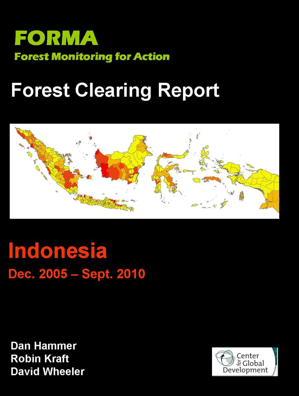
2 FORMA: Forest Monitoring for Action FORMA uses freely-available satellite data to generate rapidly-updated online maps of tropical forest clearing. We have designed it to provide useful information for local and national forest conservation programs, as well as international efforts to curb greenhouse gas emissions by paying to keep forests intact. Although rich countries are willing to pay for forest conservation in developing countries like Indonesia, results must be monitored to ensure that effective measures are identified, and to sustain public support for payments that could reach billions of dollars annually. FORMA is designed to facilitate forest conservation by identifying where -- and when -- forest clearing has occurred on a monthly basis. FORMA identifies forest clearing by analyzing publicly-available satellite data from NASA and other public and academic institutions. In particular, it relies on changes in vegetation color and the incidence of fires that indicate forest clearing. This information makes it easier to know where to intervene to stop the spread of forest clearing, and is intended to complement national forest monitoring programs and local forest conservation efforts. We provide a brief technical introduction to FORMA in this report. A full description is available from the Center for Global Development at The site includes an online map implementation for Indonesia that enables users to zoom to any local area in the country. This report draws on FORMA to describe and analyze forest clearing in Indonesia from 2000 to 2010, with a particular focus on monthly changes from December, 2005 to September, During the next several months, the FORMA project will post similar reports for all tropical forest countries in Asia, Africa and the Americas. Monthly updates will follow, along with downloadable GIS datasets for local policy applications. 1
3 National Forest Clearing in Indonesia Since 2005 Hansen, et al. (2008) 1 provide the most recent published estimate of forest clearing in Indonesia that employs a globally consistent methodology. For , they report forest loss as 3.36% of Indonesia s year-2000 forested area. 2 FORMA s estimate for the same period is effectively identical: 3.29% as of February, Figure 1: Indonesian Forest Clearing Rate (%), Mar Sept Figure 1 and Table 1 show what has happened since then. Indonesian deforestation has continued, and a surge four years ago caused total forest clearing since 2005 to be greater than clearing during the first half of the decade. However, the pace has Monthly Deforestation Rate (%) Source: FORMA Trend declined during the past four years, from 1.11 million hectares cleared in 2006 to 761,000 hectares in Monthly clearing in 2010 averaged 41,336 hectares from January to September, 48.6% less than clearing for the same period in 2006 (80,483 hectares). Table 1: Forest Clearing in Indonesia, Cumulative Area Deforested as % of Year-2000 Forest Area Change in % From Previous Year Jul2006 Jul2007 Jul2008 Jul2009 Jul2010 Annual Hectares Cleared Monthly Hectares Cleared (Jan-Dec) Monthly Hectares Cleared (Jan-Sept) Year ,106,572 92,214 80, ,104 70,842 76, ,198 67,683 68, ,083 63,424 67, ,020 41,336 Source: FORMA: 1 Hansen, M.C., Stehman, S.V., Potapov, P.V., Loveland, T.R., Townshend, J.R.G., DeFries, R.S., Pittman, K.W., Stolle, F., Steininger, M.K., Carroll, M., Dimiceli, C Humid tropical forest clearing from 2000 to 2005 quantified using multi-temporal and multi-resolution remotely sensed data. PNAS, 105(27), Hansen, Ibid, Table 1. 2
4 Regional Trends Indonesian provinces are divided into subprovinces (kabupatens), whose relative forest clearing rates are also tracked by FORMA. Figure 2 displays major islands, island groups and provinces in Indonesia. Figure 2: Indonesian Islands and Provinces Sumatra Kalimantan Sulawesi Maluku Irian Jaya Java Bali Figure 3 displays rates of forest clearing across Indonesia from 2000 to Subprovinces are colored from the highest rate of clearing (deep red) to the lowest (yellow). The figure shows three distinctive clusters of rapid clearing, in north-central Sumatra, central Kalimantan (on a north-south axis), and southern Irian Jaya. These patterns reflect the estimates in Hansen, et al. (2008). Figure 4 shows how clearing patterns have changed since The map assigns the deepest red to subprovinces whose forest clearing rates have strongly accelerated during ; orange to subprovinces that have accelerated, but less strongly; and yellow to subprovinces where clearing has decelerated since The map shows striking shifts in clearing intensity: Sumatran clearing has intensified to the northwest and south of the area with the fastest clearing in In Kalimantan, the most intense clearing has shifted from the previous north-south axis to the southern and western coastal areas. In eastern Indonesian, recent acceleration is also visible in Sulawesi, Maluku and, to a lesser degree, southern Irian Jaya. 3
5 Figure 3: Forest Clearing Rates in Indonesian Subprovinces, Sumatra Kalimantan Sulawesi Irian Jaya Java Maluku Forest-Clearing Rate Figure 4: Acceleration and Deceleration of Forest Clearing, Sumatra Kalimantan Sulawesi Irian Jaya Much Faster Faster Slower Java Maluku How FORMA Estimates Indonesian Forest Clearing FORMA utilizes data recorded daily by the Moderate Resolution Imaging Spectrometer (MODIS), which operates on NASA's Terra and Aqua (EOS PM) satellite platforms. Although its signal-processing algorithms are relatively complex, FORMA is based on a common-sense observation: Tropical forest clearing typically involves the burning of biomass and pronounced temporary or long-term changes in vegetation color, as the original forest is cleared and replaced by pastures, croplands or plantations. Accordingly, FORMA constructs forest-clearing indicators from MODIS-derived data on the incidence of fires and changes in vegetation color as identified by the Normalized Difference Vegetation Index (NDVI). It then calibrates to local forest clearing by fitting a statistical model that relates the MODIS-based indicator values to the best available information on actual forest clearing in each area. FORMA incorporates local characteristics of the forest by dividing Indonesia into WWF ecoregions 3 and separately fitting the model to 3 4
6 data for each ecoregion. The dependent variable for each pixel is coded 1 if it has experienced forest clearing within the relevant time period, and 0 otherwise. The MODIS-based indicator values are the independent variables. For all tropical countries except Brazil, the best available data on recent forest clearing have been published in the Proceedings of the National Academy of Sciences by Hansen, et al. (2008) 4, who estimate the incidence of forest clearing for 500m parcels in the humid tropics. We calibrate FORMA using the map of forest cover loss hotspots (henceforth referred to as the FCLH dataset) published by Hansen, et al. for the period Using the FCLH pan-tropical dataset for , FORMA fits the calibration model to observations on forest clearing for 1 km 2 (100-hectare) cells in each Indonesian ecoregion. As we document in our technical paper on FORMA, 6 the model s predicted spatial probability distribution provides a very close match to the spatial incidence of FCLH forest clearing. FORMA then applies the fitted model to monthly MODIS indicator data for the period December, 2005 to September, The output for each month is a predicted forest clearing probability for each 1 km 2 cell outside of previously deforested areas, as identified in the FCLH map. Since FORMA estimates a probability of forest clearing for each cell, it is straightforward to add probabilities across cells to calculate the expected area cleared in a province, subprovince or other geographic area. Since even small areas can include thousands of 1 km 2 cells, error averaging ensures relatively small deviations from FCLH forest clearing estimates for those areas. 7 We use this approach to estimate forest clearing in each area of interest, by month. For the Indonesia report, we develop forest clearing estimates at the national, provincial and subprovincial levels. FORMA s online mapping implementation can be used to view the spatial and temporal pattern of forest clearing within each geographic area. 4 See footnote 1 for the citation. 5 In Brazil, higher resolution estimates are also available annually from the INPE PRODES program. We have used these estimates to test the accuracy of our FCLH-based calibration methodology. For more information on PRODES, see Projeto PRODES: Monitoramento da Floresta Amazonica Brasileira por Satelite. 6 Dan Hammer, Robin Kraft and David Wheeler FORMA: Forest Monitoring for Action--Rapid Identification of Pan-tropical Deforestation Using Moderate-Resolution Remotely Sensed Data. Center for Global Development Working Paper No For example, a square area 50 km on a side contains 2,500 1 km 2 cells. 5
Major atmospheric emissions from peat fires in SEA during non-drought years: Evidence from the 2013 Sumatran fires David Gaveau
 SOCP/YEL Paul Hilton/SOCP/YEL Reuters Major atmospheric emissions from peat fires in SEA during non-drought years: Evidence from the 2013 Sumatran fires David Gaveau Salim MA, Hergoualc h K, Locatelli
Forest and Land Cover Monitoring by Remote Sensing Data Analysis
 Low Carbon Asia Research Network (LoCARNet) 3rd Annual Meeting Bogor, Indonesia November 24 26, 2014 Forest and Land Cover Monitoring by Remote Sensing Data Analysis Muhammad Ardiansyah Center for Climate
New York Declaration on Forests
 Progress on the New York Declaration on Forests Technical Annexes Goal 1: At least halve the rate of loss of natural forests globally by 2020 and strive to end natural forest loss by 2030 November 2015
Title. Author(s) Yulianti, Nina; Hayasaka, Hiroshi; Usup, Aswin. Citation Global environmental research, 16(1):
 Yulianti, Nina; Hayasaka, Hiroshi; Usup, Aswin. Citation Global environmental research, 16(1):") Title Recent Forest and Peat Fire Trends in Indonesi The Latest Decade by MODIS Hotspot Data Author(s) Yulianti, Nina; Hayasaka, Hiroshi; Usup, Aswin Citation Global environmental research, 16(1): 105-116
Title Recent Forest and Peat Fire Trends in Indonesi The Latest Decade by MODIS Hotspot Data Author(s) Yulianti, Nina; Hayasaka, Hiroshi; Usup, Aswin Citation Global environmental research, 16(1): 105-116
How safe is Beijing s Air Quality for Human Health? Naresh Kumar Θ
 How safe is Beijing s Air Quality for Human Health? Naresh Kumar Θ Abstract: The success of the 2008 Olympics will be largely impacted by the level of air pollution in Beijing. The World Health Organization
Assessment of areas of selective logging and burned forests in Mato Grosso State, Brazil, from satellite imagery
 XIV WORLD FORESTRY CONGRESS, Durban, South Africa, 7-11 September 2015 Assessment of areas of selective logging and burned forests in Mato Grosso State, Brazil, from satellite imagery Yosio Edemir Shimabukuro
GLOBAL PALM OIL SOURCING UPDATE KEY FACTS. SIGNIFICANT PROGRESS: 87% global traceability to the mill at the end of 2016 MARCH 2017
 GLOBAL PALM OIL SOURCING UPDATE KEY FACTS MARCH 2017 SIGNIFICANT PROGRESS: 87% global traceability to the mill at the end of CLOSING THE TRACEABILITY GAP: Continuing collaborative efforts to improve traceability
GEO-DRI Drought Monitoring Workshop, May 10-11, 2010, Winnipeg, Manitoba Drought in Southeast Asia
 GEO-DRI Drought Monitoring Workshop, May 10-11, 2010, Winnipeg, Manitoba Drought in Southeast Asia Orn-uma Polpanich Stockholm Environment Institute Asia Bangkok, Thailand Southeast Asia Is located on
Remotely-Sensed Fire Danger Rating System to Support Forest/Land Fire Management in Indonesia
 Remotely-Sensed Fire Danger Rating System to Support Forest/Land Fire Management in Indonesia Orbita Roswintiarti Indonesian National Institute of Aeronautics and Space (LAPAN) SE Asia Regional Research
Indonesia Burning The Impact of Fire on Tropical Peatlands : Focus on Central Kalimantan
 Indonesia Burning The Impact of Fire on Tropical Peatlands : Focus on Central Kalimantan A collaborative research programme: *Sue Page, Univ. of Leicester, UK *Jack Rieley, Univ. of Nottingham, UK *Florian
Optimal use of land surface temperature data to detect changes in tropical forest cover
 JOURNAL OF GEOPHYSICAL RESEARCH, VOL. 116,, doi:10.1029/2010jg001488, 2011 Optimal use of land surface temperature data to detect changes in tropical forest cover Thijs T. van Leeuwen, 1,2 Andrew J. Frank,
Indonesian Forest Resource Monitoring
 Indonesian Forest Resource Monitoring Belinda Arunarwati Margono Jakarta, 12 November 2014 Aketajawe-lolobata - Maluku From global data set.. to national http://earthenginepartners.appspot.com/science-2013-global-forest
DMC 22m Sensors for Supertemporal Land Cover Monitoring. Gary Holmes DMC International Imaging Ltd June 2014
 DMC 22m Sensors for Supertemporal Land Cover Monitoring Gary Holmes DMC International Imaging Ltd June 2014 DMC 2 nd Generation Satellites UK-DMC2 and Deimos-1 launched 29 th July 2009 650km swath width
Remote sensing technology contributes towards food security of Bangladesh
 American Journal of Remote Sensing 2013; 1(3): 67-71 Published online June 20, 2013 (http://www.sciencepublishinggroup.com/j/ajrs) doi: 10.11648/j.ajrs.20130103.12 Remote sensing technology contributes
CHARACTERIZATION OF THE AREAS IN SUCCESSION PROCESS (REGROWTH) IN THE AMAZON REGION
 IN THE AMAZON REGION") CHARACTERIZATION OF THE AREAS IN SUCCESSION PROCESS (REGROWTH) IN THE AMAZON REGION Iris de Marcelhas e Souza Iris@ltid.inpe.br Yosio Edemir Shimabukuro Yosio@ltid.inpe.br Valdete Duarte Valdte@ltid.inpe.br
CHARACTERIZATION OF THE AREAS IN SUCCESSION PROCESS (REGROWTH) IN THE AMAZON REGION Iris de Marcelhas e Souza Iris@ltid.inpe.br Yosio Edemir Shimabukuro Yosio@ltid.inpe.br Valdete Duarte Valdte@ltid.inpe.br
FOREST COVER MAPPING AND GROWING STOCK ESTIMATION OF INDIA S FORESTS
 FOREST COVER MAPPING AND GROWING STOCK ESTIMATION OF INDIA S FORESTS GOFC-GOLD Workshop On Reducing Emissions from Deforestations 17-19 April 2007 in Santa Cruz, Bolivia Devendra PANDEY Forest Survey of
Estimating present and future wildfire pollution in the U.S.
 Estimating present and future wildfire pollution in the U.S. (and a bit about the 2015 haze in Indonesia) Shannon N. Koplitz and Christopher G. Nolte USEPA/ORD/NERL/SED/EFAB In support of the Air Climate
15 th International Peat Congress in Sarawak, Malaysia Is Peatland Utilization the Main Cause of Land Fire in Indonesia?.
 15 th International Peat Congress in Sarawak, Malaysia www.ipc2016.com Is Peatland Utilization the Main Cause of Land Fire in Indonesia?. Moch. Riza Kasfari*), Yudha Asmara Adhi, Basuki Somawinata and
SCOPE FOR RENEWABLE ENERGY IN HIMACHAL PRADESH, INDIA - A STUDY OF SOLAR AND WIND RESOURCE POTENTIAL
 SCOPE FOR RENEWABLE ENERGY IN HIMACHAL PRADESH, INDIA - A STUDY OF SOLAR AND WIND RESOURCE POTENTIAL Gautham Krishnadas and Ramachandra T V Energy & Wetlands Research Group, Centre for Ecological Sciences,
Peatland degradation fuels climate change
 Peatland degradation fuels climate change Peatland degradation fuels climate change An unrecognised and alarming source of greenhouse gases November 2006. Government representatives from almost all countries
Forest Biomass Change Detection Using Lidar in the Pacific Northwest. Sabrina B. Turner Master of GIS Capstone Proposal May 10, 2016
 Forest Biomass Change Detection Using Lidar in the Pacific Northwest Sabrina B. Turner Master of GIS Capstone Proposal May 10, 2016 Outline Relevance of accurate biomass measurements Previous Studies Project
Earth Observation for Sustainable Development of Forests (EOSD) - A National Project
 - A National Project") Earth Observation for Sustainable Development of Forests (EOSD) - A National Project D. G. Goodenough 1,5, A. S. Bhogal 1, A. Dyk 1, R. Fournier 2, R. J. Hall 3, J. Iisaka 1, D. Leckie 1, J. E. Luther
Earth Observation for Sustainable Development of Forests (EOSD) - A National Project D. G. Goodenough 1,5, A. S. Bhogal 1, A. Dyk 1, R. Fournier 2, R. J. Hall 3, J. Iisaka 1, D. Leckie 1, J. E. Luther
A global perspective on land use and cover change
 A global perspective on land use and cover change Alan Belward The Global Environment Monitoring Unit Institute for Environment and Sustainability European Commission Joint Research Centre 21027 Ispra
Land Accounts in Indonesia
 Land Accounts in Indonesia outline! Background! Land Accounts in Indonesia! Technical issues faced and resolutions Consideration Background Government Regulation on Environmental Economic Instruments (PP
Map accuracy assessment methodology and results for establishing Uganda s FRL
 Map accuracy assessment methodology and results for establishing Uganda s FRL 1 Table of Contents Acronyms... 4 1 Introduction... 5 2 Process and institutions involved... 5 3 Objectives of the map AA...
Bioenergy & Sustainability a SCOPE series volume Launching the report of a global assesment of bioenergy sustainability
 Environmental Security and Ecosystem Services: biodiversity, restoring soils and protecting ecosystems in bioenergy landscapes, harmonizing forestry and agriculture policies Mateus Batistella Embrapa Satellite
THE FRA 2010 REMOTE SENSING SURVEY
 Forest Resources Assessment Working Paper 155 THE FRA 2010 REMOTE SENSING SURVEY AN OUTLINE OF OBJECTIVES, DATA, METHODS AND APPROACH DECEMBER,2009 The Global Forest Resources Assessment Programme Sustainably
PEATLAND RESTORATION in Indonesia
 PEATLAND RESTORATION in Indonesia Dr. Myrna A. Safitri Deputy of Education, Socialization, Participation and Partnership Presentation at Japan Pavilion of COP 22, Marrakech November 11, 2016 Indonesian
A REVIEW OF FOREST FIRE INFORMATION TECHNOLOGIES IN VIETNAM
 A REVIEW OF FOREST FIRE INFORMATION TECHNOLOGIES IN VIETNAM Le Thanh Ha 1, Nguyen Hai Chau 1, Nguyen Hoang Nam 1, Bui Quang Hung 1, Nguyen Thi Nhat Thanh 1, Nguyen Ba Tung 1, Do Khac Phong 1, Nguyen Van
30 Years of Tree Canopy Cover Change in Unincorporated and Incorporated Areas of Orange County,
 30 Years of Tree Canopy Cover Change in Unincorporated and Incorporated Areas of Orange County, 1986-2016 Final Report to Orange County July 2017 Authors Dr. Shawn Landry, USF Water Institute, University
POTENCY AND CHALLENGES OF NUCLEAR COGENERATION FOR INDONESIA EXPERIMENTAL POWER REACTOR DESIGN
 POTENCY AND CHALLENGES OF NUCLEAR COGENERATION FOR INDONESIA EXPERIMENTAL POWER REACTOR DESIGN ERLAN DEWITA NATIONAL NUCLEAR ENERGY AGENCY OF INDONESIA (BATAN) 21 23 November 2016 Background The Republic
Available online at ScienceDirect. Procedia Environmental Sciences 33 (2016 ) Suria Darma Tarigan*
 Suria Darma Tarigan*") Available online at www.sciencedirect.com ScienceDirect Procedia Environmental Sciences 33 (2016 ) 386 392 The 2 nd International Symposium on LAPAN-IPB Satellite for Food Security and Environmental Monitoring
Available online at www.sciencedirect.com ScienceDirect Procedia Environmental Sciences 33 (2016 ) 386 392 The 2 nd International Symposium on LAPAN-IPB Satellite for Food Security and Environmental Monitoring
CLUA Cerrado Biome Assessment August 2016
 CLUA Cerrado Biome Assessment August 2016 Maps by topic Background Physical geography 2 Land use and vegetation 3 Carbon stock 4 Protected, indigenous, and community lands 5 Priority areas for potential
Implementation of Forest Canopy Density Model to Monitor Forest Fragmentation in Mt. Simpang and Mt. Tilu Nature Reserves, West Java, Indonesia
 Implementation of Forest Canopy Density Model to Monitor Forest Fragmentation in Mt. Simpang and Mt. Tilu Nature Reserves, West Java, Indonesia Firman HADI, Ketut WIKANTIKA and Irawan SUMARTO, Indonesia
2014REDD302_41_JCM_PM_ver01
 Joint Crediting Mechanism Proposed Methodology Form Cover sheet of the Proposed Methodology Form Form for submitting the proposed methodology Host Country Indonesia Name of the methodology proponents Mitsubishi
Tools Development and Outcomes. Dave Skole Michigan State University
 Tools Development and Outcomes Dave Skole Michigan State University Background Carbon2Markets Carbon Climate Livelihoods Focus of our work is on a range of issues in Carbon Measurement Forests, woodlands,
Mapping global soil Carbon stocks and sequestration potential
 Mapping global soil Carbon stocks and sequestration potential John Latham Renato Cumani UN/FAO Environmental Assessment and Monitoring Unit FAO, Rome, April 16, 2009 1 Food and Agriculture Organization
Zambia s National Forest Monitoring System
 Zambia s National Forest Monitoring System Deuteronomy Kasaro 1 and Julian Fox 2 1. REDD+ National REDD+ Coordinator deutkas@yahoo.co.uk 2. UN-REDD MRV facilitator Julian.fox@fao.org ZAMBIA Programme Goal:
Fragmentation of tropical forests a forgotten process in the global carbon cycle?
 Fragmentation of tropical forests a forgotten process in the global carbon cycle? A. Huth 1,2, K. Brinck 1,3, R. Fischer 1, J. Groeneveld 1, S. Puetz 1 1 Helmholtz Centre for Environmental Research, Leipzig,
Air Quality and Early-Life Mortality: Evidence from Indonesia s Wildfires
 Air Quality and Early-Life Mortality: Evidence from Indonesia s Wildfires Seema Jayachandran Stanford University April 2008 Introduction Wildfires blanketed parts of Indonesia in smoke in August-October
IFAD/GEF Project on Rehabilitation and Sustainable Use of Peatland Forests in Southeast Asia
 IFAD/GEF Project on Rehabilitation and Sustainable Use of Peatland Forests in Southeast Asia 8 th Meeting of Ministerial Steering Committee on Transboundary Haze Pollution 19 August 2009, Singapore Transboundary
Long-term trends and interannual variability of forest, savanna and agricultural fires in South America
 Carbon Management ISSN: 78-34 (Print) 78-32 (Online) Journal homepage: http://www.tandfonline.com/loi/tcmt2 Long-term trends and interannual variability of forest, savanna and agricultural fires in South
Taking New Tropical Peat Fire Evaluation Methods Nation-wide In Indonesia
 Taking New Tropical Peat Fire Evaluation Methods Nation-wide In Indonesia Laura Graham, Grahame Applegate, Andri Thomas, Erianto Indra Putra, Kevin Ryan and Mark Cochrane part of the NASA-funded SDSU-IPB
Towards a European Forest Fire Simulator
 Towards a European Forest Fire Simulator J.M. Baetens Research Unit Knowledge-based Systems Ghent University COST Green Engineering Camp July 2, 2012 KERMIT J.M. Baetens (KERMIT) A European Forest Fire
RESTORE+: Addressing Landscape Restoration for Degraded Land in Indonesia and Brazil. Picture credit Stora Enso
 RESTORE+: Addressing Landscape Restoration for Degraded Land in Indonesia and Brazil Picture credit Stora Enso IMPORTANCE OF RESTORATION Bonn Challenge and Global Partnership on Forest Landscape Restoration
The EU forestry wood chain in a globalised world
 The EU forestry wood chain in a globalised world Eric Arets, Alexander Moiseyev, Bastiaan Louman, Markku Kanninen, Jean-Marc Roda, Jean Noël Marien, Birger Solberg, Maarit Kallio, Elke Stehfest & Mark
Monitoring Deforestation and Forest Degradation on National and Local Level in Indonesia
 Monitoring Deforestation and Forest Degradation on National and Local Level in Indonesia Dr. Ir. Ruandha A. Sugardiman, M.Sc. Dr. Ir. Belinda A. Margono, M.Sc. Ministry of Environment and Forestry Indonesia
Remote Sensing of Environment
 RSE-07187; No of Pages 10 ARTICLE IN PRESS Remote Sensing of Environment xxx (2008) xxx-xxx Contents lists available at ScienceDirect Remote Sensing of Environment journal homepage: www.elsevier.com/locate/rse
Deliverable 15 submitted to Biodiversity and Agricultural Commodities Program (BACP)
") Deliverable 15 submitted to Biodiversity and Agricultural Commodities Program (BACP) October, 2012 Aliança da Terra presentation Aliança da Terra (AT) is a Non-Governmental Organization formed by farmers,
Deliverable 15 submitted to Biodiversity and Agricultural Commodities Program (BACP) October, 2012 Aliança da Terra presentation Aliança da Terra (AT) is a Non-Governmental Organization formed by farmers,
Modelling sustainable grazing land management Relevant research in Agriculture and Global Change Programme
 Modelling sustainable grazing land management Relevant research in Agriculture and Global Change Programme Ben Henderson & Mario Herrero 20 July 2015 AGRICULTURE AND GLOBAL CHANGE / AGRICULTURE FLAGSHIP
Applying InVEST to Decisions III: Sumatra Nirmal Bhagabati and Emily McKenzie
 Applying InVEST to Decisions III: Sumatra Nirmal Bhagabati and Emily McKenzie Why Sumatra? Rich biodiversity Vast carbon stocks in forests and peat soils Locally important services (hydrological, NTFPs
Land Demand and Land Potential of Central Java in 2030: a Forecast to Promote More Balanced Development Policy. By Wiwandari Handayani
 Land Demand and Land Potential of Central Java in 2030: a Forecast to Promote More Balanced Development Policy By Wiwandari Handayani CENTRAL JAVA - INDONESIA Area: 32.548,2 Km2 Population: 32.177.730
Development of Sub National FREL in West Kalimantan
 Development of Sub National FREL in West Kalimantan Hideyuki Kubo JICA Expert Indonesia Japan Project for Development of REDD+ Implementation Mechanism (IJ REDD+) 10 November 2016 Presentation 1. West
Pontianak, October 1-2, 2013
 Workshop for Climate Change Mitigation Through the Cooperation between Ministry of Forestry, Provincial Government of West Kalimantan, and Japan International Cooperation Agency Pontianak, October 1-2,
Deforestation, shifting cultivation, and tree crops in Indonesia: nationwide patterns of smallholder agriculture at the forest frontier
 , shifting cultivation, and tree crops in Indonesia: nationwide patterns of smallholder agriculture at the forest frontier Draft 1.0 24 May 1996 Comments welcome Kenneth M. Chomitz Charles Griffiths Environment,
A look past and a look forward. David Skole Michigan State University
 A look past and a look forward David Skole Michigan State University Antecedents ca. 1988-94 There were important antecedents to the NASA LCLUC program Two important drivers: Large scale Landsat databases
IOP Conference Series: Earth and Environmental Science. Related content OPEN ACCESS
 IOP Conference Series: Earth and Environmental Science OPEN ACCESS Indonesian drought monitoring from space. A report of SAFE activity: Assessment of drought impact on rice production in Indonesia by satellite
NUSANTARA REPORT. Review of Regional Economic and Finance JULI 2013
 JULI 2013 For further information, please contact: Bank Indonesia Department of Economic Research and Monetary Policy Monetary Policy Group Regional Economic and Inflation Division Ph. 021-3818161, 3818868
ANALYSIS OF CHANGES IN VEGETATION BIOMASS USING MULTITEMPORAL AND MULTISENSOR SATELLITE DATA
 ANALYSIS OF CHANGES IN VEGETATION BIOMASS USING MULTITEMPORAL AND MULTISENSOR SATELLITE DATA A. Akkartal a*, O. Türüdü a, and F.S. Erbek b a stanbul Technical University, Faculty of Civil Engineering,
LOW CARBON TOWN-INDICATOR (LCT-I) BITUNG CITY, NORTH SULAWESI, INDONESIA
 BITUNG CITY, NORTH SULAWESI, INDONESIA") LOW CARBON TOWN-INDICATOR (LCT-I) BITUNG CITY, NORTH SULAWESI, INDONESIA NOLDY TUERAH CEO, BOARD OF INTEGRATED ECONOMIC DEVELOPMENT ZONE (IEDZ) MANADO-BITUNG The 2 nd Workshop APEC Low-Carbon Model Town
LOW CARBON TOWN-INDICATOR (LCT-I) BITUNG CITY, NORTH SULAWESI, INDONESIA NOLDY TUERAH CEO, BOARD OF INTEGRATED ECONOMIC DEVELOPMENT ZONE (IEDZ) MANADO-BITUNG The 2 nd Workshop APEC Low-Carbon Model Town
The role of Remote Sensing in Irrigation Monitoring and Management. Mutlu Ozdogan
 The role of Remote Sensing in Irrigation Monitoring and Management Mutlu Ozdogan Outline Why do we care about irrigation? Remote sensing for irrigated agriculture What are the needs of irrigators? Future
Ukraine Winter Wheat: Sowing Progress (All years include estimated area for Crimea.)
") Sept 7 Sept 14 Sept 21 Sept 28 Oct 5 Oct 12 Oct 19 Oct 26 Nov 2 Nov 9 Nov 16 Million hectares 1,000 hectares 8,000 7,000 6,000 Ukraine Winter Wheat: Sowing Progress (All years include estimated area for
Sept 7 Sept 14 Sept 21 Sept 28 Oct 5 Oct 12 Oct 19 Oct 26 Nov 2 Nov 9 Nov 16 Million hectares 1,000 hectares 8,000 7,000 6,000 Ukraine Winter Wheat: Sowing Progress (All years include estimated area for
User Awareness & Training: LAND. Tallinn, Estonia 9 th / 10 th April 2014 GAF AG
 User Awareness & Training: LAND Tallinn, Estonia 9 th / 10 th April 2014 GAF AG Day 2 - Contents LAND (1) General Introduction to EO and the COPERNICUS Sentinel Programme Overview of COPERNICUS/GMES LAND
Summary of the socio-economic impact of Copernicus in the EU
 Summary of the socio-economic impact of Copernicus in the EU ESA Since the entry into service of Copernicus first satellite, Sentinel-1A, in 2014, the impacts of the programme are witnessed beyond the
Supporting Elephant Conservation in Sri Lanka through MODIS imagery
 Supporting Elephant Conservation in Sri Lanka through MODIS imagery Kithsiri Perera* a and Ryutaro Tateishi b a Faculty of Engineering and Surveying and Australian Centre for Sustainable Catchments, University
Rural road in Indonesia: Issues and challenges
 Rural road in Indonesia: Issues and challenges Max Antameng Senior Policy Advisor Directorate General of Highways Ministry of Public Works- Indonesia Indonesia Overview Indonesia, an archipelago of 17,504
Pathways of Agricultural Expansion Across the Tropics:
 Pathways of Agricultural Expansion Across the Tropics: Implications for C Payback Times Holly K. Gibbs David H. Smith Conservation Research Fellow Woods Institute for the Environment Food Security and
Global Earth Observation System of Systems (GEOSS) Related Activities in Indonesia
 Related Activities in Indonesia") Global Earth Observation System of Systems (GEOSS) Related Activities in Indonesia Mahdi Kartasasmita Indonesian National Institute of Aeronautics and Space (LAPAN) Introduction Earth observation (EO)
Global Earth Observation System of Systems (GEOSS) Related Activities in Indonesia Mahdi Kartasasmita Indonesian National Institute of Aeronautics and Space (LAPAN) Introduction Earth observation (EO)
Application of SAM and SVM Techniques to Burned Area Detection for Landsat TM Images in Forests of South Sumatra
 20 2nd International Conference on Environmental Science and Technology IPCBEE vol.6 (20) (20) IACSIT Press, Singapore Application of SAM and SVM Techniques to Burned Area Detection for Landsat TM Images
CIFOR Presentation: Oil and Forests
 CIFOR Presentation: Oil and Forests Center for International Forestry Research Does Oil Wealth Help Conserve Forests? Macroeconomic impacts on tropical forests and their utilisation Sven Wunder, Economist,
Food Security Monitoring Bulletin. Food Security Monitoring Bulletin INDONESIA. Special focus:food Affordability and Ramadan. Volume 6, April 2017
 Food Security Monitoring Bulletin Food Security Monitoring Bulletin INDONESIA Special focus:food Affordability and Ramadan Volume 6, April 2017 Summary FOOD AFFORDABILITY AND RAMADAN Recommendations [
To provide timely, accurate, and useful statistics in service to U.S. agriculture
 NASS MISSION: To provide timely, accurate, and useful statistics in service to U.S. agriculture What does NASS do? Administer USDA s Statistical Estimating Program Conduct the 5-year Census of Agriculture
Forest Transparency Brazilian Amazon
 Heron Martins, Antônio Fonseca; Carlos Souza Jr.; Márcio Sales & Adalberto Veríssimo (Imazon) SUMMARY In, SAD detected 84 km² of totaled 74.5 km² in. Compared to deforestation in the Legal Amazon with
Scientific evidence exists
 Review of Swaziland fire disaster using GIS and MODIS data by Wisdom Dlamini, Swaziland National Trust Commission During the month of July 2007, a series of fires erupted throughout Swaziland destroying
Real-time crop mask production using high-spatial-temporal resolution image times series
 Real-time crop mask production using high-spatial-temporal resolution image times series S.Valero and CESBIO TEAM 1 1 Centre d Etudes Spatiales de la BIOsphre, CESBIO, Toulouse, France Table of Contents
CHAPTER SEVEN ENVIRONMENTAL IMPACTS OF OIL PALM PLANTATIONS
 CHAPTER SEVEN ENVIRONMENTAL IMPACTS OF OIL PALM PLANTATIONS The development of oil palm plantations in Jambi Province has been associated with adverse impacts on the environment. Local NGOs have been the
Global Biomass Map Products
 Global Biomass Map Products Maurizio Santoro (santoro@gamma-rs.ch) & GlobBiomass team Status of global biomass datasets at UW3 A first version of the global AGB and GSV datasets were delivered to ESA and
Deforestation evaluation by synergetic use of ERS SAR coherence and ATSR hot spots: The Indonesian fire event of 1997
 sar/atsr synergy 34 Deforestation evaluation by synergetic use of ERS SAR coherence and ATSR hot spots: The Indonesian fire event of 1997 E. Antikidis, O. Arino, H. Laur & A. Arnaud ESA Directorate of
Crop Mapping in the Hindu Kush Himalaya Region
 Crop Mapping in the Hindu Kush Himalaya Region Mir Matin Faisal Mueen Qamar Haqiq Rahmani Krishna Vadrevu Lee Ellenburg NASA ICIMOD Varun Tiwari Nabin Kumar Yadav Begum Rabeya Rushi MAIL, GIRoA Noorullah
Do conservation incentives increase the effectiveness of protected areas?
 Introduction Do conservation incentives increase the effectiveness of protected areas? Elı as Cisneros, Jan Bo rner, Stefano Pagiola and Sven Wunder ZEF Bonn, ZEF Bonn, CIFOR Rio de Janeiro, World Bank
Outlook for Woodchip Imports in China
 Outlook for Woodchip Imports in China Bob Flynn Director, International Timber, RISI JOPP Seminar, Tokyo, June11, 2013 Thousand BDMT As recently as 2003, China was the fourth largest supplier of hardwood
Modeling and remote sensing link soil water storage effects to forest LAI
 Modeling and remote sensing link soil water storage effects to forest LAI Richard Waring 1 & Auro Almeida 2 1 College of Forestry Oregon State University Corvallis, Oregon, U.S.A. 2 CSIRO Sustainable Ecosystems
PRODES - INPE INPE. PRODES Methodology- PRODES Methodology - INPE. Mapping and Monitoring Deforestation and Forest Degradation in the Brazilian Amazon
 Mapping and Monitoring Deforestation and Forest Degradation in the Brazilian Amazon GOFC-GOLD GOLD Symposium on Forest and Land Cover Observations March 21st-26 26 th, 2006 Jena, Germany Carlos Souza Jr.
Estimating Agricultural Water Consumption impacts on water level fluctuations of Urmia Lake, Iran
 Estimating Agricultural Water Consumption impacts on water level fluctuations of Urmia Lake, Iran Leila Eamen 1 and A. B. Dariane* 2 1. MSc. Student, Dept. of Civil Eng., K.N. Toosi Univ. of Tech. 2. Associate
Supplemental Information. Data
 1 2 3 4 5 6 7 8 9 10 11 12 13 14 15 16 17 18 19 20 21 22 23 24 25 26 27 28 29 30 31 32 33 34 35 36 37 38 39 Supplemental Information Data Forest cover in the year 2000 was estimated by applying a 50% threshold
Livestock s Long Shadow Environmental Issues and Options
 Livestock s Long Shadow Environmental Issues and Options Pierre Gerber Methane to Markets Partnership Expo Beijing - 30 October 2007 Henning Steinfeld Pierre Gerber Tom Wassenaar Vincent Castel Mauricio
By Gerald Urquhart, Walter Chomentowski, David Skole, and Chris Barber
 By Gerald Urquhart, Walter Chomentowski, David Skole, and Chris Barber The clearing of tropical forests across the Earth has been occurring on a large scale basis for many centuries. This process, known
GTAP Research Memorandum No. 28
 Development of the GTAP Land Use Data Base for 2011 By Luis Peña-Lévano Farzad Taheripour Wallace E. Tyner GTAP Research Memorandum No. 28 June 2015 Development of the GTAP Land Use Data Base for 2011
Solar Power Realities
 Solar Power Realities Supply-Demand Characteristics, Storage and Capital Costs by Peter Lang Abstract This paper provides a simple analysis of the capital cost of solar power and energy storage sufficient
Emission Reduction Program in Indonesia: A District-wide Approach to REDD+
 Emission Reduction Program in Indonesia: A District-wide Approach to REDD+ Agus Sari Chair, Working Group on Funding Instruments Presidential Task Force on REDD+ Paris,France, June 23, 2013 WWF-Indonesia
Large-scale opposition among Borneo villagers to deforestation
 Large-scale opposition among Borneo villagers to deforestation 10 September 2013 by Rhett A. Butler https://news.mongabay.com/2013/09/large-scale-opposition-among-borneo-villagers-todeforestation/ EXERPT
PROJECT INFORMATION DOCUMENT (PID) IDENTIFICATION/CONCEPT STAGE Report No.: PIDC103763
 IDENTIFICATION/CONCEPT STAGE Report No.: PIDC103763") PROJECT INFORMA DOCUMENT (PID) IDENTIFICA/CONCEPT STAGE Report No: PIDC103763 Project Name Region Country Financing Instrument Project ID Borrower Name Implementing Agency Environmental Category Date PID
PROJECT INFORMA DOCUMENT (PID) IDENTIFICA/CONCEPT STAGE Report No: PIDC103763 Project Name Region Country Financing Instrument Project ID Borrower Name Implementing Agency Environmental Category Date PID
The Chinese Grain for Green Program assessing the sequestered carbon from the land reform
 The Chinese Grain for Green Program assessing the sequestered carbon from the land reform Madelene Ostwald 1,2,*, Jesper Moberg 2, Martin Persson 2, Jintao Xu 3 1 Centre for Climate Science and Policy
POTENTIAL IMPROVEMENT FOR FOREST COVER AND FOREST DEGRADATION MAPPING WITH THE FORTHCOMING SENTINEL-2 PROGRAM
 POTENTIAL IMPROVEMENT FOR FOREST COVER AND FOREST DEGRADATION MAPPING WITH THE FORTHCOMING SENTINEL-2 PROGRAM L. Hojas-Gascón a, d, A. Belward a, H. Eva a*, G. Ceccherini a, O. Hagolle b, J. Garcia c,
Standard Methods for Estimating Greenhouse Gas Emissions from Forests and Peatlands in Indonesia
 Standard Methods for Estimating Greenhouse Gas Emissions from Forests and Peatlands in Indonesia (Version 2) Chapter 4: Standard Method Forest Management Events and Regimes MINISTRY OF ENVIRONMENT AND
Chapter 6: Adapting to a Changing Climate
 Chapter 6: Adapting to a Changing Climate Coastline in East Nusa Tenggara Photo: Endro Adinugroho MAIN MESSAGES Investing In a More Sustainable Indonesia Specific areas of Indonesia are highly vulnerable
An Assessment of the Pull between Landuse and Landcover in Southwestern Nigeria and the Ensuing Environmental Consequences
 An Assessment of the Pull between Landuse and Landcover in Southwestern Nigeria and the Ensuing Environmental Consequences R.O. OYINLOYE and J. OLOUKOI INTRODUCTION HYDRO SPHERE ATMO SPHERE BIO SPHERE
New vision for new. Water in the 21 st. challenges. century: Vision on water resources monitoring in. Vito Colloquium on. the 21 st century,
 Vito Colloquium on Vision on water resources monitoring in the 21 st century, Antwerpen, November 26, 2009 Water in the 21 st New vision for new century: challenges Global Crises Global water resources
Mato Grosso in the context of global climate change
 Mato Grosso in the context of global climate change Area: 906,807 km² Population: 2,800,000 Capital: Cuiabá Mato Grosso in the context of global climate change MATO GROSSO: IN THE HEART OF SOUTH AMERICA