Reforestation Standard of Alberta
|
|
|
- Avis Butler
- 6 years ago
- Views:
Transcription
1 Effective to April 30, 2018 Effective: 1 May, 2017 Page 1 of 315
2 Alberta Agriculture and Forestry Forestry Division Forest Management Branch 7th Floor, Great West Life Building Street Edmonton, Alberta Telephone inquiries should be directed to the Forest Management Branch at: (780) A digital copy of this document can be obtained by visiting the department s website at forestry.alberta.ca and use the following search term:. Although this document is in the public domain, permission must be secured from the Government of Alberta to reproduce any copyrighted materials contained within this document. Requests for permission should be directed to the address or telephone number listed above. Any use of trade, product, or firm names is for descriptive purposes only and does not imply endorsement or recommendation by the Government of Alberta. Suggested citation: Alberta Agriculture and Forestry Department of Agriculture and Forestry, Forestry Division, Forest Management Branch, Edmonton, Alberta. 315 p. Page 2 of 315
3 Table of Contents 1 Version and improvement history About the Forest regeneration standards in Alberta: a historical perspective Purpose Reforestation terms of reference Scope and applicability Important dates Organization of the RSA General reforestation survey standards Interpreter and field surveyor qualifications Global Positioning System MAI standards and tree species Developing MAI standards Approved tree species Stratum declarations, subdivision of openings and strata balancing Timing Opening declarations and MAI Standards assignment Subdivision of openings Strata balancing Establishment survey standard Purpose Objectives Timing Strata standards Broad Cover Group strata Regenerated yield strata Acceptable trees Under height trees Choice of Establishment survey method Reconnaissance surveys Procedures Outcome and next course of action Intensive survey Determining the sample intensity Calculating the survey grid line and plot spacing Laying out transects and plots in the field Plot assessment On-site stocking confirmation (optional) Adding columns to the Establishment Survey Tally Sheet Establishment Survey Field Map Sheet Page 3 of 315
4 Identifying areas with poor stocking Acceptable tree stocking calculations Damage and site conditions Opening status and stratum assignment Reporting Reconnaissance surveys Intensive surveys ARIS submissions Survey quality Understory Protection Establishment Survey Standard Population/ Applicability Objectives Terminology Opening Stratification Opening Stratification Timing Opening Stratification Standards Understory Protection Establishment Survey Timing Understory Protection Establishment Survey Stocking Standards C UP Stocking Standards Total Opening-Level Stocking Standards Minimum Height Thresholds Acceptable Trees Choice of Establishment Survey Method Aerial Reconnaissance Surveys Procedures Outcome and Next Course of Action Intensive Surveys Determining Sample Intensity Calculating Survey Grid Line and Plot Centre Spacing Laying Out Transects and Plot Centre Locations in the Field Deleting Plot Centre Locations Moving Plot Centre Locations Adding Plot Centre Locations Plot Layout Assessing Plots Adding Columns to the Survey Tally Sheet On-Site Stocking Confirmation (Optional) Calculating Acceptable Tree Stocking Calculating C UP Stocking Calculating Total Opening-Level Stocking Calculating Coniferous, Deciduous and Total Stocking for Openings Being Re-Declared to Non-UP Strata Understory Protection Establishment Survey Map Sheet Identifying Areas with Poor Stocking Damage and Site Conditions Determining Opening Status Page 4 of 315
5 Satisfactorily Restocked to Understory Protection Standard (SR) Not Satisfactorily Restocked to Understory Protection Standard (NSR) Satisfactorily Restocked to Reduced Understory Protection Standard (SRR) 102 Not Satisfactorily Restocked to Reduced Understory Protection Standard (NSRR) Satisfactorily Restocked to RSA Establishment Survey Standard (SR) Not Satisfactorily Restocked to RSA Establishment Survey Standard (NSR)104 Reporting Aerial Reconnaissance Surveys Intensive Surveys ARIS submissions Survey Quality Understory Protection Establishment Survey Summary, Tally Sheets and Field Map Performance survey standard Purpose Objectives Timing Aerial photography acquisition Field survey Aerial Stratification System Aerial photography acquisition Standards for submission of openings to Alberta Standards for aerial photography Process for distributing negatives Softcopy development Scanning Standards Aerial triangulation standards Stratification Opening boundaries Recording administrative information Imagery Interpretation Unique polygon identifier Higher-level stratification Enhanced Forest Management Delineating the Net Assessment Area (Field NAA ) Stratifying the Net Assessment Area into Sampling Units Silviculture records and field calibration Tree species composition and density classes Stratification standard Recording Sampling Unit attribute information Regeneration layer species composition Regeneration layer total density Regeneration layer average height Regeneration layer spatial distribution Regeneration layer mixedwood pattern Page 5 of 315
6 Residual layer species composition Residual layer total density Residual layer crown closure Residual layer average height Residual layer spatial distribution Assessment of stocking (optional) Regeneration layer coniferous, deciduous and total stocking Stratifying the Net Assessment Area for Poorly Regenerated Areas Stratification standards Recording Poorly Regenerated Area attribute information Poorly Regenerated Area species composition Poorly Regenerated Area total density Poorly Regenerated Area average height Standardized attribute data dictionary Spatial data format standards Stratification quality assessment and control procedures Sample design for field surveys Guiding principles for development of the sample design Defining the population of openings for sampling Sample design input requirements Rare strata standards Sample design Field sample selection computer program Field sample inclusion probability Allocating field plots to Sampling Units Guiding principles Procedure Field procedures Field and plot layout Plot measurements Basic plot Tree species Western gall rust Tally by species Shrub cover Detailed plot Tree species Top height Total age Obtaining stand level estimates of basal area (optional)151 Performance Survey Sheets Non-photo system Defining the population of openings to be surveyed Page 6 of 315
7 Stratifying each opening Unique polygon identifier Delineating the Net Assessment Area (Field N_NAA ) Stratifying the Net Assessment Area into strata (Sampling Units) Stratification standard Recording strata (Sampling Units) attribute information Stratifying the Net Assessment Area for Poorly Regenerated Areas Stratification standard Recording Poorly Regenerated Area attribute information 158 Standardized attribute data dictionary Spatial data format standards Stratification quality assessment and control procedures Timber Disposition Holders Field procedures Sample intensity Calculating the survey grid line and plot spacing Field layout Adding plots Plot layout Plot measurements Basic plot Tree species Western gall rust Tally by species Shrub cover Detailed plot Tree species Top height Total age Obtaining stand level estimates of basal area (optional)170 Performance Survey Sheets Compilation procedures Field data compilation procedures Opening1: Master opening list Ground1: Unit header Ground2: Plot header Ground3: Basic plot Ground4: Detailed plot Ground5: Optional diameter measurements Ground6: Optional 130 cm coniferous tree tally Opening MAI and composition label compilation procedures The RSA Compiler Compilation of input variables Computation of Sampling Unit MAI forecasts Compilation of MAI and composition label to the opening-level Page 7 of 315
8 Performance survey final reporting procedures Purpose Submission versus reporting Applicability Accountability Digital folder and file nomenclature Aerial Stratification System Annual reporting Aerial photography Scanning Aerial Triangulation Softcopy Stratification Sample selection RSA Compiler *.mdb file and field maps Quality assurance Summary report Non-photo System Annual reporting Stratification RSA Compiler *.mdb file and maps Quality assurance Summary report Reporting medium Reporting Checklist and Validation Acceptance audit by the Forest Management Branch Deciduous Standard for Conditional Satisfactorily Restocked (CSR) and Not Satisfactorily Restocked (NSR) openings Timing Stocking Acceptable trees Stocking standard Performance survey Sheets (D Standard CSR/NSR) Performance Survey Information Sheet D Standard CSR/NSR Determining the sample intensity Calculating the survey grid line and plot spacing Defining ecosite and site drainage classifications Applicability Stratification by ecosite or drainage class Laying out transects and plots in the field Plots to delete Moving plots Adding plots Plot layout Plot assessment Performance Survey Tally Sheet D Standard CSR/NSR Page 8 of 315
9 Performance Survey Field Map Sheet D Standard CSR/NSR Identifying poorly stocked (NSR) areas Performance Survey Summary Sheet D Standard CSR/NSR Performance survey (D Standard CSR/NSR) reporting requirements Paper reports Digital reports ARIS reporting Quality assurance standard Quality assurance principles and components Training Aerial photography interpretation quality assessments Field quality assessments Data quality assessments ( paper check ) Training Establishment surveys Performance surveys Aerial photography stratification Purpose 214 Qualified auditors Procedures Reporting of audit results to the department Audits completed by the department Field check surveys and ARIS reporting verification Field check surveys Verification of Performance survey information reported to ARIS. 229 Reporting of audit results to the department Audits completed by the department Implementation Appendices Appendix 1. FMA and FMU specific Landbase Designation Code and Mean Annual Increment (MAI) standards Appendix 2. Forest Management Agreements Appendix 3. Acceptable tree species by Forest Management Agreement (FMA) and Forest Management Unit (FMU) Appendix 4. Establishment Survey Summary Sheet and data dictionary, Field Map Sheet and Tally Sheet Appendix 5. Statistical accuracy for stocking surveys Appendix 6. Number of sample plots for stocking surveys Appendix 7. Summary of line and plot spacing Appendix 8. RSA Stocking Reporting Cover Page Appendix 9. Forest Areas Appendix 10. Acquisition of aerial photography data dictionary Appendix 11. Sampling Unit and Poorly Regenerated Areas stratification data dictionaries Appendix 12. Examples of net downs and hierarchical delineation of Sample Units261 Page 9 of 315
10 Appendix 13. Process to determine mixedwood pattern Appendix 14. Master Opening List data dictionary Appendix 15. Mechanics of the field sample selection computer program Appendix 16. Performance sheets Appendix 17. Performance field survey data dictionaries, Aerial Stratification and Nonphoto Systems Appendix 18. Compiled GYPSY input variable descriptions and data dictionaries 282 Appendix 19. Compiled GYPSY output data dictionary Appendix 20. Opening MAI and label compilation procedures and data dictionaries294 Appendix 21. Aerial Stratification and Non-photo System performance survey reporting checklist and validation Appendix 22. Glossary Page 10 of 315
11 List of Tables Table 2-1. Important milestones within a Timber Year Table 5-1. Summary of stratum declarations, subdivision of openings, and balancing activities by Timber year of cut and regenerated stratum and yield based system commencement date Table 6-1. Establishment survey timing and opening eligibility by Timber Year of Cut or clock re-set date or disturbance date Table 6-2. Establishment survey minimum stocking by Broad Cover Group Standard Table 6-3. Establishment survey minimum acceptable coniferous and deciduous tree height requirements by Broad Cover Group Standards and Natural Subregion Table 6-4. Number of sample plots required by opening area (ha) category Table 6-5. Summary of Intensive survey plot-level assessments Table 6-6. Establishment Survey Field Map Sheet information by survey type Table 6-7. Intensive survey map symbols and definitions Table 7-1. Understory Protection terms and definitions Table 7-2. Number of sample plot centres required by opening area (ha) Table 7-3. Summary of intensive survey plot assessments Table 7-4. Example C UP and total opening-level stocking calculation Table 7-5. Map sheet information requirements by survey type Table 7-6. Ground survey map symbols and definitions Table 7-7. Example opening status declarations Table 7-8. Understory Protection Establishment Survey Summary Sheet Opening Header data dictionary (all non-optional fields must be populated) Table 8-1. Aerial photography acquisition timing and opening eligibility by Timber Year of Cut or clock re-set date or disturbance date Table 8-2. Performance field survey timing and opening eligibility by Timber Year of Cut or clock re-set date or disturbance date Table 8-3. Net Assessment Area, anthropogenic and natural deletion codes Table 8-4. Tree species composition class definitions Table 8-5. Density class definitions Table 8-6. Adjacent density class tolerances Table 8-7. List of tree species names and associated codes Table 8-8. Spatial distribution codes and descriptions Table 8-9. The weighted coefficient of variation (CV) standard by coniferous (C) and deciduous (D) MAI selection priority Table Sample Unit minimum and maximum number of Basic and Detailed plots Table Top height tree species selection rules Table Net Assessment Area, anthropogenic, and natural deletion codes for the Non-photo system Table Species composition class definitions, Non-photo System Table Density class definitions for the Non-photo system Table Data dictionary for Sampling Unit attribute data, Non-photo System Table Data dictionary for Poorly Regenerated Areas attribute data, Non-photo System Table NAA sample intensity requirements, Non-photo System Table Sample Unit sample intensity requirements, Non-photo System Table Top height tree species selection rules Page 11 of 315
12 Table Performance survey results submission requirements to the Alberta Regeneration Information System (ARIS; see ARIS manual for reporting requirements) Table 9-1. Performance survey minimum tree height and average height of acceptable deciduous tree requirements by Natural Subregion, Species, drainage class, and ecosite (D Standard) Table 9-2. Minimum stocking requirements for D Standard CSR/NSR Performance survey Table 9-3. Sampling requirements for D Standard CSR/NSR Performance surveys Table 9-4. Regeneration survey map symbols Table Attribute evaluation categories Table Performance survey field data quality standards (DQS) and measurement quality objectives (MQO; tolerances). The data quality standard is applied at the Sample Unit-level for the Aerial Stratification System and the opening-level for the Non-photo System Table Parameters compared in the verification of Performance survey information reported to ARIS Table Establishment Survey Summary Sheet Opening Header data dictionary (all nonoptional fields must be populated) Table Statistical accuracy requirements by opening size Table Required number of sample plots by opening size Table Line and plot spacing, number of plots, and allowable error by opening or NAA area Table Forest Area codes Table Data dictionary for dbase attribute file Table Interp1: Data dictionary for interpreted Sampling Unit attribute data (Aerial Stratification System only) Table Interp2: Data dictionary for interpreted Poorly Regenerated Areas attribute data (Aerial Stratification System only) Table Interp3: Data dictionary for optional interpreted Sampling Unit stocking data (Aerial Stratification System only) Table Opening1: Data dictionary for Master Opening List (Aerial Stratification and Nonphoto Systems) Table Ground1: Unit header data dictionary Table Ground2: Plot header data dictionary Table Ground3: Basic plot data dictionary Table Ground4: Detailed plot data dictionary Table Ground 5: Optional diameter measurements data dictionary Table Ground 6: Optional 130 cm coniferous tree tally data dictionary Table Total age exclusion criteria by tree species group Table GYPSY Input: Compiled GYPSY input variables and data dictionary Table MAI Output: Compiled GYPSY output variables and data dictionary Table Strata-level: Sampling stratum reporting, Aerial Stratification System Table SU Level: Sampling Unit reporting, Aerial Stratification and Non-photo Systems Table Opening-level: Opening reporting, Aerial Stratification and Non-photo Systems Page 12 of 315
13 List of Figures Figure 2-1. Reforestation timeline Figure 5-1. Stratum declaration, subdivision of openings, and balancing timeline Figure 5-2. Aggregation priorities by Base 10 stratum Figure 5-3. Balance table Figure 6-1. Sample plot distribution diagram Figure 7-1. Example Understory Protection opening Figure 7-2. Sample plot centre distribution diagram Figure 7-3. Process to determine the stocking status of an Understory Protection opening following an establishment survey Figure 8-1. Example of opening boundary overlap (in yellow) and area clearly harvested but not within any opening boundary Figure 8-2. Mixedwood pattern Figure 8-3. Sampling Unit Performance field survey sample intensities Figure 8-4. Sample plot distribution diagram Figure 8-5. General overview of the Opening MAI and composition label compilation procedures, Aerial Stratification System Figure 8-6. General overview of the opening MAI and composition label compilation procedures, Non-photo System Figure 8-7. Example of folder nomenclature for an Aerial Stratification System program Figure 8-8. Example of folder nomenclature for the as_softcopy folder (Figure 8-7) for an Aerial Stratification System program Figure 8-9. Example of folder nomenclature for a Non-photo System program Figure Summary of the reporting elements, Aerial Stratification System Figure Summary of the reporting requirements, Non-photo System Figure 9-1. Performance Survey Information Sheet D Standard CSR/NSR Figure 9-2. Sample plot distribution diagram (D Standard CSR/NSR Performance surveys) Figure 9-3. Performance Survey Tally Sheet D Standard CSR/NSR Figure 9-4. Performance Survey Field Map Sheet D Standard CSR/NSR Figure 9-5. Performance Survey Summary Sheet D Standard CSR/NSR Figure Form 1: RSA Stratification Audit Summary Form Figure Criteria 1: RSA Delineation Standards Audit Criteria Figure Form 2: RSA Delineation Standards Audit Form Figure Criteria 2: RSA Attribute Standards Audit Criteria Figure Form 3: RSA Sampling Unit (SU) Attribute Audit Form Figure Form 4: RSA Poorly Regenerated Area (PRA) Attribute Audit Form Figure Plot-on-plot audit tally sheet Figure Map of Forest Areas Figure Decision key to determine the appropriate SITE_INDEX value to use for a tree species group within a Sampling Unit. Priority tree species are: trembling aspen (Aw) for the Aw tree species group; lodgepole pine (Pl) for the Pl tree species group; white spruce (Sw) for the Sw tree species group; and, black spruce (Sb) for the Sb tree species group Page 13 of 315
14 1 Version and improvement history The (RSA) became the standard for determining the level of reforestation success relative to approved forest management plans on May 1, Subsequent improvements to the standard are summarized below. Date Approved by Improvement May 1, 2011 Darren Tapp Section 3. MAI standards, declarations, subdivision of cutblocks, and balancing Table 3-1. Summary of stratum declarations, subdivision of cutblocks, and balancing activities by Timber Year of Cut and regenerated yield based system commencement date has been updated to reflect additional FMUs. Section 4. Establishment survey Section Plot assessment. A new tally sheet (Establishment Tally Sheet B) has been added to reflect the use of GPS for locating plots in the field (Appendix 3). These are plots that have had their plot locations pre-determined using GIS. For those plots located using a compass or GPS (as a compass) and distance measuring device, surveyors shall use Establishment Survey Tally Sheet A. Section Acceptable tree stocking calculations. The Establishment survey Summary Sheet (Appendix 3) has been reformatted. Section 4.11 Opening status and stratum assignment. An intensive survey must be used to confirm a Let-It-Grow (LIG) treatment prescription. Section 4.14 Understory Protection Standards. Mixed aspen/spruce understory protection standards are being developed and will be available on the SRD website in the near future. Section 5. Performance survey Section Standards for submission of openings to Alberta. A complete and final shape file must be submitted to Alberta by 31 January annually. Alberta will post a map of the annual program and send out letters of declaration by 28 February. Timber disposition holders are to return letters of declaration by 15 March annually. Table 5-9 Minimum sample size requirements by species composition strata. Douglas-fir has been added to the list of strata. The sample size is 15 for this stratum. Section Field sample selection computer program. The Sample Selection Tool (v p) and associated User s Manual is the standard for selecting Sample Units to sample in Effective: 1 May, 2017 Page 14 of 315
15 Date Approved by Improvement the field. Section Opening MAI and composition label compilation procedures. The RSA Compiler (v pp and associated User s Manual is the Performance survey compilation standard for the Aerial Stratification and Non-photo Systems. The Microsoft Access file created by the compilation process shall be submitted to FMB as outlined in Sections and (Annual Reporting). This reporting requirement is reflected in the Reporting checklist and validations (Appendix 20). May 1, 2012 Darren Tapp Appendices Appendix 2 Acceptable tree species. A complete list of acceptable tree species by FMA and FMU is available. Appendix 7 Reforestation Stocking Survey Reporting Cover Page has been updated to include the listing of opening numbers for which regeneration survey audits were completed. Appendix 17 Compiled GYPSY input variables description and data dictionary. The description of the input variables (stand age, density, total age, site index, percent stocking, and basal area) was part of the 2010 RSA (Section ). This description can now be found in Appendix 17. Appendix 19 Opening MAI and label compilation procedures and data dictionaries. The description of the compilation procedures (computing sampled strata-level MAI, applying sampled strata-level MAI to population of openings, computing area-weighted MAI for openings, and generating area-weighted strata composition labels for openings) was part of the 2010 RSA (Section 5.7). This description can now be found in Appendix 19. Appendix 21 Glossary. Terms have added to the Glossary. Section 2. General reforestation survey standards Section 2.1. Interpreter and field surveyor qualifications: Clarification of what is meant by under the direct supervision of a RFP or AVI Level III Interpreter. Section 4. Establishment survey Section 4.3. Timing: Table 4-1 Establishment survey timing and opening eligibility by Timber Year of Cut was expanded to the 2017/2018 Timber Year of Cut. Section Establishment Survey Field Map Sheet: Table 4-6. Establishment Survey Field Map Sheet information by Establishment survey type was added. Section Understory protection standards: This section of the RSA was removed. Section 5. Performance survey Section 5.3. Timing: Table 5-1. Aerial photography acquisition Page 15 of 315
16 Date Approved by Improvement timing and opening eligibility by Timber Year of Cut expanded to the 2011/2012 Timber Year of Cut. Table 5-2. Aerial photography acquisition timing and opening eligibility by Timber Year of Cut expanded to the 2011/2012 Timber Year of Cut. Section Standards for submission of openings to Alberta: Beginning in the 2013/2014 Timber Year, timber disposition holders will be responsible for organizing and managing their own aerial photography acquisition program. Section Standards for aerial photography: New standards for digital photography for RSA stratification have been added. May 1, 2013 Darren Tapp RSA Compiler changes A Warning to the user to recompile upon editing data was added. PLOT_ID field length bug was fixed. PLOT_ID field leading zero auto-populate configuration bug was fixed. Stratum character length limitation was fixed. Computing culmination MAI where the primary species type is not present was resolved. Species group duplicate for top height was fixed. GYPSY COM DLL troubleshooting tips were added to the User s Manual. Results from the recent Alberta Regeneration Information System (ARIS) Data Review indicate an unacceptable level of reporting of Mean Annual Increment (MAI) metrics for ineligible openings. Ineligibility may result from having multiple Performance surveys reported, the wrong methodology used to complete the survey or Performance survey results reported when a Performance survey was not required. Where openings are included in an Aerial Stratification Performance survey program and subsequently found to be ineligible, the population of openings across which the MAI results are applied is then known to have incorrect MAI values. Erroneous MAI values result as the Sample Unit selection weighting becomes incorrect when openings are removed, and/or if Sample Units within ineligible openings were selected for field sampling, as these data are not eligible to contribute to the MAI estimates. Ensuring the sampling population is accurately defined is a fundamental requirement for the sub-sampling approach used in the RSA aerial programs. It is imperative that NO changes be made to any Aerial Stratification Performance survey program population once the Sample Selection Tool has been run. Effective 1 May 2013, should any changes be necessary to sample populations once results are reported to the department, the program results will be deemed unacceptable, and each program shall be required to be re-run to ensure MAI results are Page 16 of 315
17 Date Approved by Improvement reported appropriately. The date of the submission of the re-run program results to ARIS and FMB shall be deemed the date of the acceptable survey results are completed as prescribed by Timber Management Regulation and late survey submissions will be subject to a non-compliance investigation. General Understory Protection Establishment Survey Standards, to be available shortly, will be an amendment to the 2013 RSA. Effective 1 May, 2014 the Understory Protection Establishment Survey Standards will be located in Section 7 of the RSA. The Section header was changed from Declarations to Opening declarations and MAI Standards assignment Clarification provided around declarations, MAI assignment, and how they will be used. Establishment survey standard Section 4.4 was divided into two sub-sections: Section Broad Cover Group strata and Section Regenerated yield class strata. This is the first year openings declared to regenerated yield strata are eligible for Establishment surveys. The Establishment Survey Technical Working Group (ESTWG), composed of government and industry representatives, is task with developing new Establishment survey standards that link to Performance surveys. New Establishment survey standards should be available for 1 May In the interim openings declared to a regenerated yield class stratum, timber disposition holders have the option to either wait one year to complete Establishment surveys (using outcomes from the ESTWG) or complete Establishment surveys to the broad cover group standards ( C, CD, DC, D ) based on the yield stratum declarations as mapped to the broad cover groups and report on the leading coniferous tree species group based on acceptable tree stocking. Reconnaissance walk-through and Intensive surveys are acceptable methods for confirming a Let-it-Grow (LIG) treatment prescription. The Reconnaissance aerial survey is not an acceptable method for confirming a LIG treatment prescription. Performance survey standard Effective 1 May, 2013, the department is no longer taking requests for the acquisition of aerial photography for future Performance surveys. Timber Disposition holders are responsible for managing their own photo acquisition program. The department will, however, facilitate the 2013 photo acquisition program, as described in the 2012 RSA, for requests made by January 31, Table 1-1 was updated to reflect change in department s Page 17 of 315
18 Date Approved by Improvement responsibilities for photo acquisition. Clarification provided to Section Standards for submission of openings to Alberta. To facilitate the audit of opening boundaries changes, a shape file used to identify openings for photo acquisition is required. This has been a requirement since the 2011 RSA for timber disposition holder managing their own program. Shape files must be included with the Performance survey package reported to the Forest Management Branch on or before 15 May. Section and Figure 5-6 have been updated to reflect this requirement. In addition, this requirement has been added to the Aerial Stratification and Non-photo System Performance survey reporting checklist and validation (Appendix 20). Section Process for distributing negatives: repealed as of 1 May, 2013 as all departmental coordinated RSA photographs are digital. Section Field and plot layout and Section Plot layout: Locating plots in the field for audit purposes has been problematic with approximately 20% of plots not locatable during inspections. This has implications for the department verification of Performance survey results. A 19 month plot centre marker requirement or submission of results by the fall of each year is required. Annual Reporting -- Aerial Stratification System Section and Non-photo System Section : Each program must be reported as one package (all required elements together). Where more than one program is being reported on a single medium, each must be clearly identified and in separate folders. Section Softcopy: Requirement for submission of Softcopy project files. Appendix 22. FMA and FMU specific Landbase Designation Code and Mean Annual Increment Standard: Supplemental document to the RSA, which will be available on the department s webpage by June 15, May 1, 2014 Darren Tapp RSA Compiler Enabled the import of Sample Selection Tool output files for newer Excel version files (XLSM or XLSX extensions). Section Standards for aerial photography: Aerial photography acquired for the purpose of Performance surveys must be digital and to the standards described in the RSA. Conventional aerial photography acquired on or after 1 May, 2014 and used for Performance surveys will not be acceptable. Section Recording administrative information: Section Imagery: RGBI will be added as an eligible code for EMULSION for digital photography. Establishment surveys Page 18 of 315
19 Date Approved by Improvement In addition to meeting the criteria for acceptable seedlings, seedlings must be on-site for a minimum of one growing season (Section 4.5). Seedling or advanced regeneration originating from layering is acceptable (Section 4.5). Understory Protection Establishment Survey Standard (Section 7). May 6, 2015 Darren Tapp Performance surveys Acquisition of conventional aerial photography is no longer permitted. The standard is digital aerial photography only, as describe in the RSA (Section ). Enhanced strata (i.e., tree improvement) must be its own population for sampling (Section ). Density class criterion for Dense under the Aerial Stratification System is >5,000 (Section , Table 5-5). Sample design for the Aerial Stratification System uses stratified random sampling (Section 5.4.5). Rare strata standards, defined as less than 10% of total annual area (ha) requiring Performance surveys and less than 100 ha, are no longer aggregated for field sampling (Section ). In addition to meeting the criteria for acceptable seedlings, seedlings must be on-site for a minimum of one growing season (Sections , , , , and ). Acceptance audit completed by the Forest Management Branch (Section ). The sample size standard for Aerial Stratification System Performance surveys will remain unchanged for the 2015/2016 timber year. However, stakeholders are advised that there will be a new sample size standard for Performance surveys completed using Aerial Stratification System effective 1 May, In order to facilitate this move to a new sample size standard, the department will provide a version of the Sample Selection Tool to stakeholders by 31 August, 2015 to aid in the planning of Performance survey programs for the 2016/2017 timber year. General The RSA has been re-formatted to meet Environment and Sustainable Resource Development formatting requirements for directives. Acceptable trees: On-site requirement increases from a minimum of one to a minimum of two growing seasons. This applies to both Establishment and Performance surveys. Section 3 MAI standards, declarations, subdivision of openings, and strata balancing Page 19 of 315
20 Date Approved by Improvement Section 3.1 Developing MAI standards: Clarification about tree species lists requirements. Section Timing: Table 3-1 Summary of stratum declarations, subdivision of openings, and balancing activities by Timber Year of Cut and regenerated yield based system commencement date no longer applies so was removed from the RSA. Section Subdivision of openings: Areas within openings containing understory protection (UP) or enhanced forest management (EFM) with forest management plan regenerated yield assumptions must be subdivided and a new opening created and reported. Clarification on how to allocate roads, landings, and backlines to UP or clearcut areas during subdivision of openings. Section Strata balancing: The timing of strata balancing based on Broad Cover Group or forest management plan specific yield class strata described in Table 3-2 Requirements for strata balancing no longer applies so was removed from the RSA. Clarification of procedures for strata balancing (pooling of openings, balance table, balance tolerance, and reporting requirements) was added to the RSA. Section 5 Performance survey Section Enhance Forest Management: Bare ground planting is used to describe openings eligible for inclusion in the enhanced forest management tree improvement population Sections and Annual Reporting: Report required elements for Aerial Stratification and Non-photo Performance surveys to the Reforestation Standard Analyst, Forest Resource Analysis The tree species code for White bark pine is used inconsistently in the RSA (e.g., Pa in the Interp 1 and 2 data dictionaries and Pw in the Ground 3 6 data dictionaries). The tree species code for White bark pine was changed to Pw for all data dictionaries and tables in the RSA. May 1, 2016 Darren Tapp General The RSA has been re-formatted to meet Alberta Agriculture and Forestry formatting requirements. A version and improvement history section (Section 1) has been added. Acceptable trees: On-site requirement remains at 2-growing seasons for the 2016/2017 timber year. This applies to both Establishment and Performance surveys. Page 20 of 315
21 Date Approved by Improvement Height shall be measured as the tree lies perpendicular from the upper most live bud to the ground (or vice versa) for all trees regardless of lean from vertical. Surveys completed using compass and distance measuring device require plot locations to be GPS. Plots centres shall be clearly located in the ground in such a way that they can be located for auditing purposes. Plots shall be marked: In the ground at the exact location where plot centre is used to measure the plot radius. In all cases, plot centre shall be marked with all-weather flagging (e.g., winter weight, blue in color preferably) attached to a wooden stick, nail, or pig-tail or in a shovel slit in the ground at plot centre. Where nails or shovel slit is used to mark plot centre, plots shall also be marked at eye-level using all-weather flagging marked the plot number attached to a sturdy tree branch closest to plot centre to allow for easy identification of the location of the plot centre. To determine if a tree is inside the plot, surveyors and auditors are to measure from the point where the plot centre marker enters the ground to the point of germination. The germination point is the point at which the coniferous and deciduous tree takes root and becomes established. For stem sprouts in trembling aspen and balsam poplar, the germination point is the point at which the sprout has originated on the original stump. If estimation is required, then assume the geometric centre of the main stem. Count a tree as within the plot when its point of germination is inside the plot even if the tree is leaning outside. Conversely, do not count a tree leaning into the plot but with its point of germination outside the plot. Clock re-set or disturbance date shall also be used when determining opening eligibility for surveys. Section 4 MAI standards and tree species Standards for landbase designation codes that reflect the four letter ARIS stakeholder code, two digit AAC approval year, FMP strata numbered sequentially and requirement for tree species lists have been added. Section 5 Stratum declarations, subdivision of openings and strata balancing Table 5-1 Summary of stratum declarations, subdivision of openings, and balancing activities by timber year of Page 21 of 315
22 Date Approved by Improvement cut and regenerated stratum and yield based system commencement date was put back into the RSA. Section 6 Establishment survey standard Section 6.13 Survey quality. The provincial QA/QC for Establishment surveys (training, field checks and data validation) remains as status quo. A provincial quality assurance quality control program will accompany the new Establishment assessment standards planned for Section 7 Understory Protection Establishment Survey Standard Requirement to submit stratification results to FMB at least one year prior to the survey being completed was removed. Stratification results are now required to accompany the survey submission package to the AAF area office. Calculation of opening-specific CUP and total openinglevel stocking must be included with the submission to the AAF areas office. Opening-specific stratification metrics must be included with the submission to the AAF area office. Section 8 Performance survey standard Clarification on: o Shape files used for photo acquisition (Section ) o Re-drawing opening boundaries (Section ) o Bare ground planting (Section ) o Measuring DBH for top height trees (Sections and ) The addition of the option to complete an assessment of stocking (optional) when stratifying the Net Assessment Area into Sample Units (Section ). A data dictionary (Interp3) was added to Appendix 11. A new Sample Selection Tool (v a). New digital folder and file nomenclature (Section 8.7.5) New quality assurance reporting requirements (Sections and ). Section 10 Quality assurance standard New section Quality assurance in Section 10 applies to Aerial Stratification and Non-photo Performance surveys. Provincial quality assurance for Establishment surveys will be added in Page 22 of 315
23 Date Approved by Improvement Therefore, reforestation obligation holders remain accountable for documenting and implementing quality control systems for Establishment surveys that includes field auditing and data validation. Surveyor training for Establishment and Performance surveys remains the responsibility of the obligation holder. 1 May, 2017 Darren Tapp Section 7 Understory Protection establishment survey standard All references to this survey standard being the pilot phase have been removed. The 50% audit requirement remains, but is now to be in place for at least the first three years that a timber disposition holder or forestry consultant carries out the standard. The 50% audit requirement will be re-assessed on a case-by-case basis after the three-year implementation period. Additional direction has been added to clarify how stocking is to be calculated if the opening is to be redeclared to a non-understory protection stratum. Additional plot stocking combinations were added (map symbols) to aid this calculation. Direction has been added to clarify reporting requirements for understory protection openings that are being re-declared to non-understory protection strata. Section 8 Performance survey standard General Specifications for Acquiring Aerial Photography replace the General Specifications for Mapping. The requirement to collect shrub cover information repealed. Place holder required so eligible code is 0 (zero). When making a request to use the Non-photo System (performance survey is due) skid clearance date is needed in addition to opening, disposition, and net harvested ha. Clarification: Table The table is now consistent with the following requirement: Where the entire NAA is between 0.1 and 1.9 ha in size, the minimum number of plots to establish in the Sampling Unit is 13 Basic plots and four (4) Detailed plots. Digital folder/file nomenclature requirement to include FMA or FMU. e.g., 1_WBLL_W6_ _as_acquisition Image, model, surface, and project files are no longer required to be submitted but must be made available upon request (using the folder/file nomenclature above and external hard drive medium) for audit purposes. Remaining required elements (shape files, sample Page 23 of 315
24 Date Approved by Improvement selection, compiler file, field maps, quality assurance, summary report, and checklist) must be submitted via using zip file format to the following address: Allocation of plots in the Summary report repealed. Requirement for performance survey stratification qualified auditors to have participated in the department s RSA stratification training workshop in 2009 repealed. Section 10. Quality assurance standard Clarification provided on performance survey field data quality standard. Standard remains relatively the same as the date quality standards first implemented in the 2016/2017 timber year. Page 24 of 315
25 2 About the Forest regeneration standards in Alberta: a historical perspective Sustained yield management, and therefore reforestation, has been a requirement in Alberta since the Forests Act of 1949 was passed. The first Alberta Regeneration Survey Standard was developed in This standard required the completion of a regeneration survey by the seventh year post harvest and used the stocked plot method to determine forest regeneration success. A cutblock was considered regenerated when 40% of mil-acre plots or more were stocked with at least one spruce or pine. This was later changed to 80% of mil-hectare plots or more stocked with at least one two year old or older pine or three year old or older spruce. In 1985, juvenile stand surveys were conducted in a sample of cutblocks considered stocked for at least 10 years. The results suggested low survival of what were considered established seedlings and those seedlings that had survived were impacted by competing vegetation. These findings were used to develop new forest regeneration standards in These standards not only included strata stocking requirements for conifer, mixedwoods, and deciduous but also required minimum height standards be met by year 8 (Establishment) and free-to-grow (FTG) standards for coniferous trees be met by year 14 (Performance). These standards also established surveyor qualifications. The FTG requirement was a competition free cylinder around each conifer crop tree. FTG required a coniferous crop tree to be free of deciduous trees and shrubs greater than two-thirds its height within 1 m radius of its stem. A review of the 1991 forest regeneration standards by the Regeneration Survey Task Force, consisting of representatives from Alberta and the forest industry was completed in March 2000 at which time the 2000 Regeneration Standards were adopted. The number of strata was increased to four (C: coniferous; CD: coniferous-leading mixedwood; DC: deciduous leading mixedwood; and D: deciduous), the minimum coniferous crop tree height was 30 cm, conditional coniferous seedlings designation was no longer available for C, CD, and DC, and a new status was introduced for the D Standard (Conditional Satisfactorily Restocked or CSR). In addition, changes were made to the FTG requirements and the concept of let-it-grow (LIG) was introduced for Establishment surveys. LIG is a retreatment strategy whereby an opening that is found to be not satisfactorily restocked (NSR) with acceptable trees may be in a satisfactorily restocked (SR) like condition when under height trees are present and considered. Under LIG, the opening is considered NSR; however, retreatment may not be necessary. In April 2003, several changes to the survey protocol and to the FTG criteria were made permitting greater levels of vegetation to be retained adjacent to coniferous crop trees that are growing well. The revised standards became effective 1 May, In 2005, a review of natural sub-region boundaries was completed and regeneration standards were updated accordingly. These revised standards became effective 1 May, Changes to regeneration surveyor certification requirements and enhanced quality control and quality assessment were made in In 2001, the Alberta Reforestation Standards Science Council (ARSSC) was charged with providing to Alberta qualitative scientific advice regarding the improvement of reforestation Page 25 of 315
26 policy. The ARSSC proposed a number of guiding principles 1, which it believed must be followed in establishing reforestation standards for public forests in Alberta. In adopting these principles, the ARSSC gave special attention to the issue of connecting regeneration standards to the growth and yield of regenerating forests and emphasized the importance of Management by Objective (MBO) as part of a long-term management strategy. MBO (or Model II) represented a move towards forest level assessments of growth linked to the assumptions made in the forest management plan (FMP). In 2004, a consultant retained by the Alberta Forest Products Association (AFPA) developed a framework to more formally link reforestation standards to long-term timber yields (i.e., Annual Allowable Cut or AAC). In consultation with Alberta, the forest industry, and silviculture experts, A Framework for Reforestation Standards Linked to Growth and Yield was published. Alberta acknowledged the document as a reasonable approach for developing alternative regeneration standards that would ultimately replace the established provincial reforestation standards. In 2005, Alberta and a forest industry technical committee began working on developing Alternative Regeneration Standards (ARS). These standards were to provide a science-based quantitative link between managed stand yields and strata assumed in the FMP and reforestation standards. The attainment of these standards will be a key early indicator of the successful development of the managed forest conditions (i.e., desired future forest) forecasted in the FMP. Managed stands meeting or exceeding FMP specific ARS demonstrates sustainability of the Annual Allowable Cut (AAC) and maintenance of strata for biodiversity (coarse filter) at the landscape level. The ARS approach was formally adopted on 1 May, 2009 and became the provincial standard on 1 May, In 2010, the ARS were renamed the Reforestation Standard of Alberta (RSA). Purpose The RSA is designed to determine the forest regeneration status of young managed stands relative to an assumed future condition. The standard provides detailed descriptions of the office and field procedures and imparts practical aids and tools to assist timber disposition holders in conducting forest regeneration assessments. The information obtained by using the RSA is intended to support a wide variety of activities including regulatory requirements, planning applications, forest regeneration monitoring, decision making, and public reporting. The RSA describes the procedures for developing mean annual increment (MAI) standards, making declarations, subdividing openings, strata balancing, conducting and reporting on Establishment and Performance surveys, strata and yield reconciliation. The RSA is designed to have procedures that are repeatable, robust, simple, unambiguous, technically defensible, and produce consistent results while maintaining operational efficiency. Specifically, the RSA: Provides the standards and procedures to assess the level of reforestation success in managed stands following harvest; 1 Alberta Reforestation Standards Science Council Linking regeneration standards to growth and yield and forest management objectives, Prepared for the Minister of Sustainable Resource Development. 29 August, p. For a digital copy of this document, visit the AAF website (forestry.alberta.ca) and use the following search term: Alberta Reforestation Standards Science Council. Page 26 of 315
27 Enables the assessment of each opening to determine the adequacy of stocking, survival, growth, and tree species composition (Establishment survey and D Standard CSR/NSR Performance survey); and, Assesses reforestation performance of each opening relative to the yields and strata assumed in the FMP (Establishment and Performance surveys). Reforestation terms of reference The Forests Act, Timber Management Regulation, Alberta Regulation 60/1973 with amendments up to and including Alberta Regulation 76/2010 provide the statutory authority for reforestation (Part 6) on public forested lands in Alberta. Specific sections within the Timber Management Regulation pertain to the requirements for reforestation, regeneration surveys, and reporting. The discussion that follows should be used as general guidance and is not legal interpretation. The Timber Management Regulation 141.1(1) requires timber disposition holders with reforestation responsibility to reforest within two years after the end of the year of cut, and reforest to a level to ensure that the reforestation standard will be met. The Timber Management Regulation (1), (2), and (3) requires timber disposition holders to comply with rules governing the source and type of tree seed and vegetative propagules used to reforest public land. These rules are described in the Alberta Forest Genetic Resource Conservation and Management Standards (FGRMS) 2. The Timber Management Regulation 141.2(1) enables the director to establish reforestation requirements including requirements for establishment and performance surveys and the methods and timing of conducting surveys. The director must publish the reforestation requirements (Timber Management Regulation 141.2(2)). The Timber Management Regulation 141.3(1) enables the Minister to establish qualifications for certification for persons undertaking specified reforestation operations on public land. Timber disposition holders shall ensure persons undertaking reforestation operation on their behalf are qualified (Timber Management Regulation (2)). Timber disposition holders shall submit to the director an establishment survey (Timber Management Regulation 141.6(1)) and a performance survey (Timber Management Regulation 141.7(1)). If the reforestation standard is not met by the end of the year in which the establishment survey is required to be submitted to the director, timber disposition holders are required to re-treat the area before the end of the following year using methods and operations approved by the director (Timber Management Regulation 141.6(2)). If, in the opinion of the director, the results of the performance survey are acceptable, reforestation is completed and no further reforestation treatments or surveys are required (Timber Management Regulation 141.7(2)). 2 For a digital copy of this document, visit the AAF website (forestry.alberta.ca) and use the following search term: Alberta Forest Genetic Resource Conservation and Management Standards. Page 27 of 315
). The Timber Management Regulation 115.")

28 Timber disposition holders responsible for carrying out reforestation shall submit to the director in a form acceptable to the director and by May 15 annually, a complete and accurate report summarizing the preceding year s reforestation program (Timber Management Regulation 143.2(2)). The Timber Management Regulation 115.1(1) defines the period of time which survey records shall be retained. This period of time is five (5) years. This section of the Timber Management Regulation also requires the timber disposition holder make any records available upon request for purposes of audit or examination by a forest officer, the director, the Minister, or a person authorized by the Minister. Figure 2-1 summarizes the reforestation terms of reference in a timeline. Figure 2-1. Reforestation timeline 3. 3 The timing of the D Standard CSR/NSR Performance surveys is not included on the timeline. See Section 5.8 for the timing requirement for this survey. Page 28 of 315
29 Scope and applicability Reforestation surveys conducted by timber disposition holders and the Forest Resource Improvement Association of Alberta (FRIAA) on public land for the purpose of fulfilling obligations of the Forests Act, Timber Management Regulation, shall be completed in accordance with the procedures described in this standard unless otherwise specified by Alberta. The RSA is the reforestation standard for public lands unless otherwise approved by Alberta. As the reforestation standard is currently in a refinement period and annual updates to the standard may be required. This version of the RSA is valid for the Timber Year beginning and supersedes all other reforestation standards previously approved by Alberta. Important dates Table 2-1 describes important RSA milestones dates within a Timber Year. Table 2-1. Important milestones within a Timber Year. Milestone 1 May Timber Year begins. Description 30 April Timber Year ends. Last date for timber disposition holders to complete surveys for reporting by 15 May. 15 May Final submissions of annual reforestation activities to ARIS. Last date to report Establishment and D Standard CSR/NSR Performance surveys to Alberta Agriculture and Forestry area offices. Last date to report Aerial Stratification and Non-photo Systems Performance surveys to the Forest Management Branch. Organization of the RSA The reforestation timeline (Figure 2-1) was used to organize the RSA. The RSA is divided into five main sections. Section 3 describes the standards for: Qualified interpreters and field surveyors; and, Global Positioning System (GPS). Section 4 describes the procedures for: Developing MAI standards; and, Acceptable tree species lists Section 5 describes the procedures for: Page 29 of 315
30 Declaring openings to regenerated yield strata; Subdividing openings; and, Strata balancing. Section 6 describes the timing, stocking standards, and procedures for completing Establishment surveys 4 including: Reconnaissance (aerial and walk-through) assessments; and, Intensive surveys. Section 7 refers to the timing, requirements, and procedures for completing Understory Protection Establishment surveys. Section 8 describes the timing, requirements, and procedures for completing Performance surveys using the: Aerial Stratification System. Non-photo System. Section 9 describes the timing, requirements, and procedures for completing D Standard Conditionally Satisfactorily Restocked (CSR) and Not Satisfactorily Restocked (NSR) Performance surveys. Section 10 describes the requirement for a quality assurance and quality control (QA/QC) program that address the following: Training; Aerial photography interpretation quality assessments; Field quality assessments; and, Data quality assessments. The appendices includes information about FMA holders, acceptable tree species, Establishment and Performance survey sheets, statistical accuracy and number of sample plots for stocking surveys, summary of line and plot spacing, reforestation survey reporting cover page, Forest Areas, examples of net downs and hierarchical delineation of Sampling Units, mixedwood pattern, data dictionaries, Performance survey checklist, glossary, and Landbase Designation Code and Mean Annual Increment Standards. 4 Applies to all silviculture systems except Understory Protection. Page 30 of 315
31 3 General reforestation survey standards These general reforestation standards apply to both Establishment and Performance surveys, as described in this. Interpreter and field surveyor qualifications The Forests Act, Timber Management Regulation, Section (1, 2, and 3), enables the Minister to: (1) Establish the qualifications for persons undertaking specified reforestation operations on public land; (2) Require timber disposition holders to ensure all persons undertaking reforestation operations have applicable certification resulting from the meeting of those qualifications; and, (3) Refuse to accept the validity of reforestation operations if they are undertaken by a person who does not have the applicable certification. Alberta deems the following as meeting the requirements for certification: Field surveyors Establishment and Performance field surveys shall be completed by Regulated Forestry Professionals (RFP) or under the direct supervision of an RFP; and, Qualified surveyors are individuals who have successfully completed Establishment and Performance survey training. Direct supervision by a RFP includes the RFP: Overseeing the surveys as they occur; and, Overseeing (i.e., direct authority over) and taking responsibility for the performance of surveyors; and, Providing direction and feedback to surveyors in a timely manner; and, Ensuring surveys conducted under their direct supervision are complete and accurate. Interpreters Stratification of regenerating openings using Softcopy shall be completed by an Alberta Vegetation Inventory (AVI) Level 2 interpreter or under the direct supervision of an AVI Level 2 interpreter; and, Qualified interpreters are individuals who have successfully completed stratification training. Direct supervision by an AVI Level 2 Interpreter includes: Page 31 of 315
32 Overseeing the stratification and interpretation as they occur; and, Overseeing (i.e., direct authority over) and taking responsibility for the performance of interpreters; and, Providing direction and feedback to interpreters in a timely manner; and, Ensuring stratification and interpretation being conducted under their direct supervision are complete and accurate. Notification of qualified interpreters and surveyors Timber disposition holders responsible for completing Establishment surveys and D Standard Performance CSR/NSR surveys shall list the names (first and last) of qualified surveyors on the Reforestation Survey Reporting Cover Page (Appendix 8). Timber disposition holders responsible for completing Performance surveys (Aerial Stratification and Non-photo Systems) shall list the names (first and last) of qualified interpreters and surveyors on the Performance survey Checklist (Appendix 21). Global Positioning System The use of Global Positioning System (GPS) for Establishment and Performance surveys is permitted. Where timber disposition holders choose to use GPS as the method for locating the Point of Commencement (POC), Tie Point (TP), and sample plot centres while conducting Establishment and/or Performance surveys, Regeneration surveyors must receive GPS training in order to be deemed qualified; The accuracy of GPS receivers shall be 10 metres horizontally at a 95% confidence level; and, The GPS receiver shall be set to position or record using the North American Datum for 1983 (NAD 83). GPS best practices include: The recommendation that GPS receivers be set to position or record in 3D mode (i.e., simultaneous observations to a minimum of four satellites); and, The recommendation that during static point-mode surveys, the minimum recording duration at each survey point should be 30 seconds with a minimum of 15 individual position fixes during this period. Page 32 of 315
33 4 MAI standards and tree species Section 4 describes the procedures for developing Mean Annual Increment (MAI) standards and the requirement for tree species lists. Developing MAI standards Development of MAI standards is a mandatory component of the forest management planning process. Once developed and approved, the MAI standards will apply to all reforestation obligation holders covered by the Forest Management Plan (FMP). Should multiple Timber Supply Analyses (TSA) be included in the FMP (i.e., a TSA run for each FMU within a FMA), then the MAI standards shall reflect each TSA. The development of MAI standards is the responsibility of the Forest Management Agreement (FMA) holder. The number of MAI standards shall reflect the number of regenerated yield strata assumed in the FMP to a minimum of the Base 10 strata and separate strata for Enhanced Forest Management (EFM), as outlined in the Forest Management Planning Standard (2006). For non-fma Forest Management Units (FMU), the department shall develop the MAI standards. Generally, the non-fma FMU MAI standards shall reflect the Base 10 strata. Each regenerated yield stratum assumed in the FMP shall have a coniferous and deciduous MAI. MAI shall be at culmination age (i.e., maximum productivity) for the primary management tree species (coniferous, C, or deciduous, D) of concern. The MAI of the secondary management tree species (C or D) of concern shall be coincident with the culmination age of the primary management tree species of concern. In addition, MAI standards shall be based on: 15 cm stump diameter, 10 cm top diameter, 30 cm stump height, and 3.66 m log length utilization standard; Gross merchantable volume (i.e., not reduced for cull); and, Yields adjusted for regeneration lag. Whether or not some regenerated yield strata are amalgamated from the Base 10 strata during the FMP development process, all Base 10 strata must have unique landbase declaration codes for proper accounting. Where two of the Base 10 strata are amalgamated in the FMP, unique landbase declaration codes will be assigned to each stratum and the two resulting strata shall share the same MAI standard. For those openings previously declared to a Broad Cover Group (BCG) stratum (i.e., C, CD, DC, and D), MAIs shall be developed once during the First Approximation process and based on the current approved TSA. BCG MAI shall be calculated by area-weighting the FMP specific regenerated yield class strata. Landbase designation codes are required for each regenerated strata (minimum Base 10 Strata plus EFM strata). The naming convention for landbase designation codes shall be: Page 33 of 315
34 1) The three or four letter ARIS stakeholder code (e.g., WBLL); and, 2) The two digit AAC approval year (e.g., 16 for 2016); and, 3) The two digit FMP regenerated yield stratum ordered as follows: 01 Deciduous 02 Hardwood/Pine 03 Hardwood/Spruce 04 White spruce/hardwood 05 Pine/Hardwood 06 Black spruce/hardwood 07 White spruce 08 Pine 09 Black spruce 10 Douglas fir EFM strata shall be ordered from 11 onward. Approved tree species The tree species list shall include those tree species used to develop FMP specific regenerated yield strata and MAI standards. At the time of MAI standard development, FMA holders shall submit a tree species list for approval. The department shall develop a tree species list for non-fma FMUs. The current approved tree species lists by FMA and FMU are shown in Appendix 3. These tree species lists help define an acceptable tree in establishment and performance surveys for the respective forest management unit. Tree species exceptions related to growth and yield model limitations are noted in the survey procedures. Page 34 of 315
35 5 Stratum declarations, subdivision of openings and strata balancing Section 5 describes the procedures for making declarations (reforestation objectives), subdividing openings, and strata balancing annual populations of openings. The procedures for making declarations and balancing described below replace those procedures described in Directive Timing Declarations of regenerated yield strata, subdivision of openings, and strata balancing shall be completed no later than one year following the end of the Timber Year of Cut (Figure 5-1). Timber Year Description Required activities and ARIS submissions May May 1 Jun Jul Aug Sep Oct Nov Dec Jan Feb Mar Apr April 30 Timber Year of Cut May May 1 - REFORESTATION START CLOCK DATE Activities completed in Timber Year 0 must be reported to ARIS by 15 May Jun Jul Aug Sep Oct Nov Dec Jan Feb Mar Apr April 30 1st year following the Timber Year of Cut May May 1 Activities completed in Timber Year 1 must be reported to ARIS by 15 May Jun Jul Aug Sep Oct Nov Dec Jan Feb Mar Apr April 30 2nd year following the Timber Year of Cut 1. Create openings (Operator code, AOP area, skid clearance date) 2. Make regenerated yield class 'preliminary' stratum declarations 3. In ARIS, populate X_OPEN, X_HARVST, X_REFRES tables 1. Subdivide cutblocks (if necessary) 2. Balance (mandatory) 3. Make regenerated yield class stratum declarations 4. In ARIS, populate X_OPEN, X_HARVST, X_REFRES tables Figure 5-1. Stratum declaration, subdivision of openings, and balancing timeline. However, the transition from the Alberta Regeneration Survey Manual to the management by objective system (stratum and yield) varies by FMA and FMU and by Timber year of Cut. Table 5-1 describes the appropriate transition procedures when making stratum declarations, subdividing openings, and balancing. Appendix 2 lists FMA holders by FMA number. Page 35 of 315
36 Table 5-1. Summary of stratum declarations, subdivision of openings, and balancing activities by Timber year of cut and regenerated stratum and yield based system commencement date. RSA Start date Activity Timber Year of Cut 2008/ / / /2012 FMA FMU Yield class Yield class Preliminary stratum Yield class Yield class stratum by stratum by declarations to: stratum* stratum April 30, April 30, May, May, May, 2010 Cutblocks eligible for subdivision? Balance to: Stratum declarations to: Preliminary stratum declarations to: Cutblocks eligible for subdivision? Balance to: Stratum declarations to: Preliminary stratum declarations to: Cutblocks eligible for subdivision? Balance to: Stratum declarations to: * FMA and non-fma FMU specific. Yes BCG Yield class stratum BCG No BCG BCG BCG No BCG BCG Yes BCG Yield class stratum Yield class stratum Yes BCG Yield class stratum BCG No BCG BCG Yes by April 30, 2012 Yield class stratum by April 30, 2012 Yield class stratum by April 30, 2012 Yield class stratum by April 30, 2011 Yes by April 30, 2012 Yield class stratum by April 30, 2012 Yield class stratum by April 30, 2012 Yield class stratum by April 30, 2011 Yes by April 30, 2012 Yield class stratum by April 30, 2012 Yield class stratum by April 30, 2012 Yes by April 30, 2013 Yield class stratum by April 30, 2013 Yield class stratum by April 30, 2013 Yield class stratum by April 30, 2012 Yes by April 30, 2013 Yield class stratum by April 30, 2013 Yield class stratum by April 30, 2013 Yield class stratum by April 30, 2012 Yes by April 30, 2013 Yield class stratum by April 30, 2013 Yield class stratum by April 30, R10 (non-fma portions) S20 (non-fma portions) S10, S14 A6, A9, A10, A11, A12, A13, B11, B52, C4, C5, C51, C52, E8, E9, E10, F10, F11, F14, F20, F23, F51, H1, G9, G10, G11, G12, G13, G14, G53, G54, L9, L51, P1, P7, P8, P14, P51, P52, P53, S9, S16, S14, S52, W51 Page 36 of 315
37 Opening declarations and MAI Standards assignment An opening declaration is composed of a landbase designation code and an associated stratum declaration. Currently, two types of opening declarations are required: (1) Declaration made by the end of the Timber Year of Cut, and, (2) Declaration made no later than one year following the end of the Timber Year of Cut. Declarations may be changed at any time up until the end of the timber year following the Timber Year of Cut. Obligation holders must ensure that the correct FMA or FMU specific landbase designation and stratum declaration codes are used when making and submitting opening declarations to ARIS. FMA and FMU specific landbase designation and stratum declaration codes are described in Appendix 1. It is the location of the opening within a FMA or FMU that determines the appropriate landbase designation code. Box 1: Making declarations using FMA or FMU specific landbase designation codes A timber disposition holder has a FMA (FMA 1) but also operates as a deciduous quota holder in an adjacent FMA belonging to another timber disposition holder (FMA 2). The landbase designation codes for the two FMAs are as follows: FMA 1 FMA 2 Stratum Stratum declaration RCTL0101 HSML9901 Deciduous D RCTL0102 HSML9902 Hardwood/Pine DC RCTL0103 HSML9903 Hardwood/Spruce DC RCTL0104 HSML9904 White spruce/hardwood CD RCTL0105 HSML9905 Pine/Hardwood CD RCTL0106 HSML9906 Black spruce/hardwood CD RCTL0107 HSML9907 White spruce C RCTL0108 HSML9908 Pine C RCTL0109 HSML9909 Black spruce C The timber disposition holder cuts two aspen stands, one in his FMA (FMA 1) and one in FMA 2. When declaring these openings in ARIS, the timber disposition holder will use the following landbase designation codes for the two openings: RCTL0101 for the opening cut in FMA 1 (the FMA belonging to the timber disposition holder); and, HSML9901 for the opening cut in FMA 2. Page 37 of 315
38 Declarations cannot be changed in ARIS after the end of year following the end of the Timber Year of Cut. Coniferous (C) and deciduous (D) MAI standards are assigned to each opening once final declarations are made in ARIS. The C and D MAI standard represents the average yield for the stratum assumed in the TSA. Landbase designation codes may be changed after the completion of Establishment Assessments; however, obligation holders will be held to the original declaration and associated stratum and yield when outcomes are evaluated (reconciled) following Performance Assessments over a quadrant. During strata reconciliation, a population of openings is assessed against the original declarations to determine if regenerated yield strata targets and MAI standards were attained. Landbase designation code and MAI standards are described in Appendix 1. Subdivision of openings The general procedures for the initial creation of openings in ARIS are as follows: Assign numbers for openings based on their centroid location (meridian, range, township, section, and grid coordinate). Populate the ARIS Opening Table (X_OPEN), Reforestation Responsibility Table (X_REFRES), Harvest Table (X_HARVST), and all mandatory elements within these tables including: o Completed silviculture activities (i.e., Leave for Natural, site preparation, planting, and stand tending); and, o Declaration based on FMA or FMU specific regenerated yield stratum. Submit all opening information (above) to ARIS by the end of the Timber Year of Cut (Figure 5-1). Subdividing openings is permitted (but not required with two exceptions) in order to facilitate the balancing tolerances for the regenerated yield strata. Subdivision of openings is required where understory protection (UP) or enhanced forest management (EFM) have occurred at the subopening level, as described below. When subdividing openings, the following rules apply: Openings created by subdivision shall have a minimum area of two (2) ha; Subdivision may be made once, and must be completed no later than one year following the end of the Timber Year of Cut; and, Openings may be subdivided into as many individual openings as required to balance (silviculture) objectives. Openings with more than one regenerated yield stratum objective must be subdivided, as follows: o Openings with UP and with at least two (2) ha of contiguous clearcut harvesting must be subdivided with the clearcut harvesting area and UP area as separate openings. Page 38 of 315
39 o Roads, landings, and backlines clearly in the UP area shall be included in the UP portion of subdivided openings. Roads and landings clearly in the clearcut area shall be included in the clearcut portion of subdivided openings. Roads, landings, or backlines shared by the clearcut and UP area may be included in either the UP portion or clearcut portion of subdivided openings. o Openings containing at least two (2) ha of contiguous EFM (tree improvement, thinning, fertilization, drainage) must be subdivided by EFM and non-efm regenerated yield class stratum where applicable. The procedures for subdividing openings shall be as follows: Where the opening is subdivided during the year following the Timber Year of Cut, previously reported silviculture activities that no longer apply to the original opening shall be deleted or amended. The original opening along with corresponding subdivided openings shall be reconciled with respect to opening numbers, opening type (e.g., UP or CC for subdivided UP openings), silviculture treatments, and areas. The activities shall be submitted in spreadsheet form to the department for deletion or amendment in ARIS. The spreadsheet shall identify the opening(s) requiring changes and any corresponding silviculture treatment information (type and area) required to be deleted or amended. Timber disposition holders shall reconcile ARIS treatment records to ensure complete and accurate information is provided. Subdivisions shall be made no later than one year following the end of the Timber Year of Cut (Figure 5-1). Two labelling options may be used when subdividing openings. Each opening number must be unique. Option 1: Use the appropriate numeric sequence for assigning opening numbers to create the opening in ARIS. Subdivide the opening by adding the letter A to the end of the numeric sequence to create a second opening. To further subdivide openings, use the same numeric sequence and append alpha characters letters B through Z. Box 2: Subdivision of openings Option 1 example. If was the numeric sequence used in the AOP and to create the opening in ARIS at year zero (Timber Year of Cut), subdividing the opening by adding the letter A will create two unique openings in ARIS: Page 39 of 315
40 (22.3 ha) Subdivision (12.8 ha) A (9.5 ha) Option 2: Use the appropriate numeric sequence for assigning opening numbers and append the letter A to the end to create the opening in ARIS. Subdivide the area by adding the letter B to the end of the numeric sequence to create a second opening. To further subdivide openings, use the same numeric sequence and append alpha characters letters C through Z. Box 3: Subdivision of openings Option 2 example. If A was the numeric sequence used in the AOP and to create the opening in ARIS at year zero (Timber Year of Cut), subdividing the opening by adding the letter B will create two unique openings in ARIS: A (22.3 ha) Subdivision A (12.8 ha) B (9.5 ha) Subdivided openings created in ARIS that remain unused due to changes in plans shall be deleted. Subdivided openings created from a single opening will retain the same Opening Table, (X_OPEN), Reforestation Responsibility Table (X_REFRES), and Harvesting Table (X_HARVST) information, except for UP openings. Annual Operating Plan (AOP) area remains the same as the approved AOP area of the original opening. Net harvest area (or Page 40 of 315
41 updated area with a disturbance, if applicable) and stratum declaration are the exceptions. The silviculture activities in ARIS shall correspond to the appropriate subdivided opening. Once subdivided openings are submitted to ARIS, subsequent subdivisions shall not be permitted. Openings remaining undivided one year after the end of the Timber Year of Cut shall be deemed complete and final; subsequent subdivision shall not be permitted. Declarations to regenerated yield strata and Net Harvest Area information for all openings shall be completed no later than one year following the Timber Year of Cut. The perimeter of each opening created by subdividing shall be determined using mappinggrade or better GPS. GPS standards of accuracy shall be 5 m horizontal accuracy at a 95% confidence level. Physical perimeter marking (i.e., high stumps) is not required. Maps illustrating the subdivided openings shall be reported in the Silviculture Schedule of the Annual Operating Plan (AOP). Digital files of openings, in a format acceptable to department, must be made available to department upon request. Strata balancing Reforestation obligation holders are required to reforest harvested areas to regenerated yield strata using transition assumptions as planned in the approved forest management plan. Therefore, the strata specific area harvested (i.e., the liability created) must balance with the strata specific area declared (i.e., the asset from declarations). A balance is required in order to properly adjudicate strata reconciliation after the completion of Performance surveys. Procedures Using the approved Alberta Vegetation Inventory (AVI), convert AVI polygons to the FMP specific TSA regenerated yield strata based on the timber supply analysis (TSA) transition assumptions (e.g., net landbase of the FMP). Overlay the opening boundaries for all areas harvested during a given Timber Year (the population). Obligation holders operating within the same TSA may pool openings. Obligation holders pooling openings for balancing purposes shall do so on a quadrant basis for a minimum of one quadrant. Opening area (ha) accounting for strata balancing purposes shall use Net Harvested Hectares only. Where the intersection of the TSA regenerated yield group boundary and the opening boundary results in strata area 2.0 ha, the following rules apply: o Regenerate yield class strata 2.0 ha are not eligible for aggregation with other regenerated yield class strata 2.0 ha; o Assign TSA regenerated yield strata to each polygon based on TSA transition Page 41 of 315
42 assumptions. o Openings may be subdivided into more than one opening (see Section 5.3) to assist with balancing of regenerated yield class strata. Where the intersection of the TSA regenerated yield stratum boundary and the opening boundary results in strata area <2.0 ha, the following rules apply: o Regenerated yield strata <2.0 ha within an opening are eligible for aggregation; o Regenerated yield strata eligibility for aggregation shall be from the stratum with the smallest area <2.0 ha to the stratum with the largest area <2.0 ha; o Beginning with the stratum with the smallest area <2.0 ha, aggregation must be with the next most common regenerated yield stratum regardless of size (ha), as defined in Figure 5-2; o To be eligible for aggregation, the total area for the regenerated yield stratum must be <2.0 ha (e.g., three 1.0 ha Sb and one 12.0 ha Pl polygons within an opening results in no aggregation of the Sb stratum because there are a total of 3.0 ha of Sb and 12.0 ha of Pl); and, o All aggregations must be accounted for as the purpose of aggregation is to help facilitate operational needs and not to enable strata conversions. o Assign a TSA regenerated yield stratum to each aggregated polygon based on TSA transition assumptions. o Openings may be subdivided into more than one opening (see Section 5.3) to assist with balancing of regenerated yield class strata. Aggregating strata is not to enable strata conversions. If the department deems this strata balancing process as being misused, the department will revoke its use. Annual populations of openings and associated regenerated yield class strata must be balanced. Tolerance by regenerated yield stratum is ±5% or ±10 ha whichever is greater. Annual balanced population of openings and associated yield strata shall be reported to: o ARIS by the end of the year (May 15) following the end of the Timber Year of Cut; and, o Regional offices by the end of the year (April 30) following the end of the Timber Year of Cut. Documentation shall include: RFP validated letter declaring the report as complete, accurate, and balanced; and, The balance table (Figure 5.3) or as approved by the department. Letters and tables may be in digital or hardcopy form. o The department may, from time to time, audit balanced populations by comparing annual population of openings submitted to ARIS with the same population openings Page 42 of 315
43 reported to Regional offices in balance tables. Is the stratum Sb? Yes Aggregate the Sb stratum with other strata using the following priority: Sw Pl Sb/Hwd Sw/Hwd Pl/Hwd Hwd/Sx Hwd/Pl Deciduous No Is the stratum Sw? Yes Aggregate the Sw stratum with other strata using the following priority: Sb Pl Sw/Hwd Sb/Hwd Pl/Hwd Hwd/Sx Hwd/Pl Deciduous No Is the stratum Pl Yes Aggregate the Pl stratum with other strata using the following priority: Sw Sb Pl/Hwd Sw/Hwd Sb/Hwd Hwd/Pl Hwd/Sx Deciduous No Is the stratum Sb/Hwd? Yes Aggregate the Sb/Hwd stratum with other strata using the following priority: Sw/Hwd Hwd/Sx Pl/Hwd Hwd/Pl Sb Sw Pl Deciduous No Is the stratum Sw/Hwd? Yes Aggregate the Sw/Hwd stratum with other strata using the following priority: Sb/Hwd Hwd/Sx Pl/Hwd Hwd/Pl Sw Sb Pl Deciduous No Is the stratum Pl/Hwd? Yes Aggregate the Pl/Hwd stratum with other strata using the following priority: Hwd/Pl Sw/Hwd Sb/Hwd Hwd/Sx Pl Sw Sb Deciduous No Is the stratum Hwd/Sx? Yes Aggregate the Hwd/Sx stratum with other strata using the following priority: Sw/Hwd Sb/Hwd Hwd/Pl Pl/Hwd Deciduous Sw Sb Pl No Is the stratum Hwd/Pl Yes Aggregate the Hwd/Pl stratum with other strata using the following priority: Pl/Hwd Hwd/Sx Sw/Hwd Sb/Hwd Deciduous Pl Sw Sb No Hwd/Pl Pl/Hwd Is the stratum Deciduous? Yes Aggregate the Deciduous stratum with other strata using the following priority: Sb/Hwd Sw Pl Sb Hwd/Sw Sw/Hwd Figure 5-2. Aggregation priorities by Base 10 stratum. Page 43 of 315
44 Figure 5-3. Balance table Page 44 of 315
45 6 Establishment survey standard The Timber Management Regulation (122.1(1) a) defines an Establishment survey as a survey conducted on an area to be reforested to determine if regeneration is established according to reforestations standards. The following Establishments survey standards are interim standards until new standards are developed. Purpose Establishment surveys determine the level of success of early silviculture activities in harvested areas. Site occupancy is the predominant parameter used to determine the level of regeneration success. Site occupancy is the degree to which trees utilize a site s available growing space. Sufficient numbers of trees are necessary to fully utilize the site s water and nutrient resources to maintain timber productivity. Site occupancy or the presence of a vegetation community is also integral to maintaining healthy ecosystems. Site occupancy is assessed using stocking. Stocking is the frequency or percentage of a sample within an opening that contains acceptable tree regeneration. In Alberta, 100% of the harvested area within an opening shall be regenerated. Openings are deemed sufficiently regenerated if stocking is 80% or greater after an Establishment survey. These Establishment survey standards apply to all silviculture systems except Understory Protection. Understory Protection Establishment survey standards are described in Section 7. Objectives The objectives of the Establishment survey are: To determine and document the reforestation status of each opening; To assess species composition and distribution of seedlings, suckers, and advanced growth with high potential for survival and future growth; To identify areas and conditions in openings where regeneration success has been inhibited or is unlikely to meet the species composition, density, and distribution targets for seedlings, suckers, and advanced growth at the required survey timing; To minimize survey time and effort where the level of regeneration success within an opening (either adequate or inadequate) is evident; and, To focus field resources on intensively sampling openings where the level of regeneration success is uncertain. Page 45 of 315
46 Timing Establishment surveys shall be completed no sooner than four (4) years and no later than eight (8) years after the end of the Timber Year of Cut or clock re-set date or disturbance date for all openings (Table 6-1). The timing of Establishment surveys is scheduled to determine reforestation treatment success. Strata standards Broad Cover Group strata The Establishment survey uses Broad Cover Group (BCG) strata standards to determine the level of regeneration success. The BCG strata are: Coniferous (C); Coniferous-leading mixedwood (CD); Deciduous-leading mixedwood (DC); and, Deciduous (D). Each BCG stratum standard has minimum coniferous tree, deciduous tree, and total stocking requirements, which, are harvest date and, in some cases, ecoregion specific (Table 6-2). Regenerated yield strata Openings were first declared to regenerated yield strata beginning 1 May, 2008 (Table 5-1). Effective 1 May, 2013, openings with skid clearance dates between 1 May, 2008 and 30 April, 2010 are eligible for Establishment surveys (Table 6-1). Although work is on-going to develop regenerated yield class strata standards, there are no finalized standards to date. Thus, the following options are available to timber disposition holders who have openings declared to a regenerated yield stratum and are eligible for Establishment survey: Defer completing Establishment surveys on openings declared to regenerated yield strata by one year ; or, Complete and report Establishment surveys to the BCG standards, as described in Table 6-2. The BCG standard for the opening is based on the stratum declaration code in ARIS (e.g., C-2000). In addition, to assist with assigning openings to strata in the next TSA, surveyors shall identify and report on the Establishment Survey Summary Sheet the leading coniferous tree species group (PL, SW, or SB) present in the opening based on acceptable tree stocking. Page 46 of 315
47 Table 6-1. Establishment survey timing and opening eligibility by Timber Year of Cut or clock re-set date or disturbance date. Y = Openings with harvest dates within the specific Timber Year of Cut are eligible for Establishment surveys during the specified Timber Year. N = Openings with harvest dates within the specific Timber Year of Cut are not eligible for Establishment surveys during the specified Timber Year. Effective: 1 May Government of Alberta 47
48 Table 6-2. Establishment survey minimum stocking by Broad Cover Group Standard. C Standard Harvest date Areas harvested after May 1, 2000 in Subalpine, Montane, Upper Boreal, Highlands, and Upper Foothills Areas harvested after May 1, 2000 in Central Mixedwood, Dry Mixedwood, Northern Mixedwood, Lower Boreal Highlands, and Lower Foothills Minimum coniferous tree stocking (%) Minimum deciduous tree stocking (%) Minimum total tree stocking (%) CD Standard Areas harvested after May 1, DC Standard Areas harvested after May 1, D Standard Areas harvested after March 1, Acceptable trees Stocking status of each opening shall be determined by assessing the spatial distribution of acceptable trees. An acceptable tree is an individual seedling, sucker, coppice (collectively SDL), or advanced (ADV) regeneration that: Is alive; and, Is an acceptable tree species (TSA or FMA or FMU specific), see Appendix 3); and, Has been on site for a minimum of two growing seasons; and, Page 48 of 315
49 Originated from seed, suckering, coppice 5, or layering (Sb); and, Achieved the minimum coniferous or deciduous tree height requirement at time of survey (Table 6-3). A growing season is defined as the period between 21 June and 1 August annually. In addition to the criteria above, Coniferous tree species shall have: o A well-defined stem, and o Two or fewer stems originating at the base of the tree; and, White and Engelmann spruce and fir trees shall have a live-crown ratio 6 of 0.33 or greater. Advance growth (ADV) is defined as those trees that were established in advance of harvest and probably will be alive when the stand is harvested next. For Establishment surveys completed in openings declared to regenerated yield strata, only acceptable trees shall be used to determine the leading coniferous tree species group. Table 6-3. Establishment survey minimum acceptable coniferous and deciduous tree height requirements by Broad Cover Group Standards and Natural Subregion. Strata Standard C, CD, DC, D Standards Natural Sub-region Central Mixedwood, Dry Mixedwood, Northern Mixedwood, Lower Boreal Highlands, Lower Foothills Subalpine, Montane, Upper Boreal Highlands, Upper Foothills Minimum acceptable coniferous tree height (cm) Minimum acceptable deciduous tree height (cm) 30* * 15 (Douglas-fir only) * 30 cm minimum acceptable coniferous tree height requirement applies to: Sw, Se, Sb, Fb, Fa, Pl, Pj, Pw, Pf, La, Lt. and Lw. 80 Height shall be measured as the tree lies perpendicular (plumb) from upper most live bud to ground (or vice versa) for all trees regardless of lean from vertical. 5 Each stem originating from coppice growth may be considered a separate acceptable tree. 6 Live crown ratio is the proportion of total stem length that is covered by living branches. It is expressed as a percentage or decimal of the total tree height. Live crown ratio is a useful indicator of the status of the tree in relation to vigor, photosynthetic leaf area, and is inversely related to stocking density. It is assumed that live crown ratio must be greater than 0.3 (30%) in order for the tree to release well. Page 49 of 315
50 Under height trees If acceptable trees are not present in the opening or portions of the opening, then under height trees, if present, may be assessed to confirm a Let-it-grow 7 (LIG) treatment prescription (see Section 6-11). Under height trees have all the characteristics of acceptable trees except that the minimum coniferous or deciduous tree height requirements (Table 6-3) are not met. The minimum height requirements for under height trees are: 15 cm for coniferous trees (Sw, Se, Sb, Fb, Fa, Pl, Pj, Pw, Pf, La, Lt, and Lw); and, 30 cm for deciduous trees (Aw, Pb, and Bw). In order for Douglas-fir (Fd) trees to be tallied as under height, Douglas-fir must be: An acceptable tree species (TSA or FMA or FMU specific); see Appendix 3); A minimum of 10 cm in height; and, On site for a minimum of two (2) growing seasons (a growing season is defined as the period between June 20 and August 1 annually). Height shall be measured as the tree lies perpendicular (plumb) from upper most live bud to ground (or vice versa) for all trees regardless of lean from vertical. For Establishment surveys completed in openings declared to regenerated yield strata, under height trees shall not be used to determine the leading coniferous tree species group. Choice of Establishment survey method Openings due for Establishment surveys shall be assessed once, at a minimum, using the following survey methods: Reconnaissance survey (Section 6-8); and/or, Intensive Survey (Section 6-9). Both survey methods determine adequacy of regeneration (stocking and consistent with mil hectare stocking). Results from Reconnaissance surveys shall be used to determine if subsequent Intensive surveys are necessary. 7 Advanced notification of the intent to declare a LIG treatment to Alberta is not required. Page 50 of 315
51 Reconnaissance surveys Procedures Reconnaissance surveys are visual evaluations of openings by qualified surveyors to determine stocking (consistent with mil hectare stocking). A visual assessment of an opening can be performed by walking through or flying over the opening. Reconnaissance fly-over (aerial) surveys are not an acceptable method for confirming a LIG treatment prescription. LIG treatment prescriptions must be confirmed by completing Reconnaissance walk-through surveys or Intensive surveys. Interpretation of aerial photographs shall not be an acceptable method for conducting Reconnaissance surveys. The entire opening shall be evaluated to adequately assess the spatial distribution of acceptable coniferous and deciduous trees. Reconnaissance surveys shall have opening level information recorded in the Acceptable Stocking Summary component of the Establishment Survey Summary Sheet (Appendix 4) including: Acceptable coniferous (C) tree stocking (%); Acceptable deciduous (D) tree stocking (%); Total stocking (%) of acceptable trees; and, An estimate of area (ha) classified as poorly stocked. For openings declared to a regenerated yield stratum, the leading coniferous tree species group (PL, SW, and SB) shall be reported based on acceptable tree stocking. While conducting Reconnaissance surveys, surveyors shall delineate areas: Classified as natural deletions (Section 6.9.3); Classified as a land-use disposition (Section 6.9.3); and, That have poor stocking or may require future silviculture treatments. The area (ha) of the natural deletion or land use disposition shall be withdrawn from the area (ha) of the opening. Where there are natural deletions or land use dispositions, these shall be reported using the Establishment Survey Field Map Sheet (Appendix 4) or produced using a GIS (i.e. block map). Where there are no natural deletions, land use dispositions, or areas of poor stocking to report for openings, the submission of an Establishment Survey Field Map Sheet to the department is not required. For Reconnaissance walk-through surveys, in addition to the above requirements for delineating natural deletions, land use dispositions, and poorly stocked area, surveyors shall record their traverse throughout the opening. Acceptable methods for recording the traverse include: Page 51 of 315
52 Using GPS track log (preferred); and, Hand drawn, to scale, on the Establishment Survey Field Map Sheet. Surveyors shall make notes describing the tie point, traverse (bearings and distance) and decisions related to the stocking and stratum determination. On the map submitted to the department, surveyors must distinguish the traverse from the opening boundary and any land use or natural deletions. It is recommended that surveyors use a series of dots (i.e., ) to record the traverse on a map. Outcome and next course of action Subject to the outcome of Reconnaissance surveys, openings shall be assigned to one of the following categories: Total acceptable tree stocking is <70.0%; Total acceptable tree stocking is 70.0% or greater but not more than 83.9%; or, Total acceptable tree stocking is 84% but not more than 100.0%. Where total acceptable tree stocking for the opening is <70% or 84% (above), an Intensive survey is not required. Where total acceptable tree stocking for the opening is 70.0% or greater but not more than 83.9% (above), an Intensive survey is required (Section 6-9). The results from the Intensive survey shall be used to report the stocking and status of the opening to the department. Intensive survey Intensive surveys shall be conducted: In lieu of Reconnaissance surveys; or, When the total acceptable tree stocking assessed by Reconnaissance surveys for openings is determined to be 70.0% or greater but not more than 83.9%; or, To confirm LIG treatment prescriptions. Intensive surveys use systematic survey methods to collect specific data for trees present in 10 m 2 (1.78 m radius) plots. The procedures for conducting Intensive surveys are: (1) Determine the sample intensity (i.e., number of plots); (2) Calculate the survey grid line and plot spacing; (3) Layout transects and plots in the field; and, (4) Assess each plot. Page 52 of 315
53 Determining the sample intensity Sample intensity requirements are described in Table 6-4. The statistical accuracy of total acceptable tree stocking, based on these sample intensities, varies by opening size (ha) but is generally within 10 to 15% with a 95% confidence (Appendix 5 and 6). Table 6-4. Number of sample plots required by opening area (ha) category. Opening area (ha) Number of sample plots required Establish a minimum of 12.4 plots per hectare Establish a minimum of 41 plots per opening or as many as are needed to cover the opening. Optional: If stocking is between 73.0% and 79.9%, increase the number of plots to Establish a minimum of 64 plots per opening or as many as needed to cover the opening. Optional: If stocking is between 73.0% and 79.9%, increase the number of plots to 84. > 24.0* 2.77 plots per hectare. *To determine the number of sample plots needed for openings larger than 24 ha, multiply the net opening area by 2.77 and round the product up to the nearest whole number. Box 4: Calculating the minimum number of plots to establish. Opening area: 26.4 ha Required number of plots per hectare (from Table 6-4): 2.77 Number of sample plots: 26.4 ha 2.77 = Product rounded up to the nearest whole number: 74 Minimum number of plots to establish: 74 Calculating the survey grid line and plot spacing When calculating line and plot spacing, two methods may be used: (1) Square spacing; and, (2) Rectangular spacing. Page 53 of 315
54 Square spacing Square spacing is a grid pattern where the distance between lines equals the distance between plots. When the total number of plots is determined and the area of the opening is known, the survey grid (plot and line spacing) can be calculated using the following formula: Plot spacing = ( Opening Area ( ha) x10,000 m 2 / ha) / required # of Plots Box 5. Square spacing example. For surveys on a 12.1 ha opening, calculate a square survey grid. From Table 6-4, a 12.1 ha opening requires a minimum of 64 plots be established. Calculate the plot spacing: Plot Spacing = ( 12.1x 10,000 / 64 = = Round off to the nearest 0.1 m: line spacing = 43.5 m & plot spacing = 43.5 m Appendix 7 lists calculated square line and plot spacing for openings of various sizes. For openings 24 ha or larger, a 60 m 60 m square grid shall be used. Rectangular spacing Rectangular spacing occurs when the line spacing differs from plot spacing. The line spacing shall not be greater than twice the plot spacing. For openings 24 ha and larger, a 60 m 60 m square grid must be used. To calculate rectangular spacing, the desired line spacing is selected then the plot spacing needed to achieve the correct number of plots is calculated. Page 54 of 315
55 Box 6. Rectangular spacing example. For surveys on a 3.9 ha opening; calculate a rectangular survey grid, assuming a line spacing of 35 m. A 3.9 ha opening requires that a minimum of 41 plots be established (Table 6-4). Plot spacing x line spacing = Opening Area (ha) x 10,000 (m2 /ha) Required # plots Plot spacing x 35 m = 3.9 ha x 10,000 m2 /ha 41 plots Plot spacing = m2 / 35 m Plot spacing = m Round off to the nearest 0.1 m: line spacing = 35.0 m & plot spacing = 27.2 m Laying out transects and plots in the field For each opening to be surveyed, the methods to locate plots in the field shall be either: (1) Compass and horizontal distance measuring device with GPS x and y coordinates captured at each plot location; or, (2) GPS to navigate to pre-determined plot locations generated using a GIS. When locating plots in the field using the compass and horizontal measuring device method (methods 1), control line(s) must be used and shall be established as follows: Establish one control line parallel to the long axis of the opening (Figure 6-1). Additional parallel control lines shall be established every 400 metres where opening width exceeds 400 m. The control line is best placed to coincide with the grid to enable points along the control line to be used as plot centres. Reference the control line in relation to the opening boundary to enable accurate mapping of the sample plot locations. Starting from the opening edge, the first survey line shall be located at one-half the interline distance. Each additional survey line is marked at the exact interline distance. Survey line intervals on the control line shall be double flagged using two different colours. The line and plot number shall be clearly written on the flagging. Beginning at the control line, the remaining individual plots shall be located at the required line and plot spacing. All measured distances must be based on horizontal or surface projections. Page 55 of 315
56 C L Figure 6-1. Sample plot distribution diagram. When locating plots in the field using the GPS to navigate to pre-determined plot locations method (method 2 above), a control line is not required. Plots to delete Areas within openings where plots are unnecessary include those under a land-use disposition or those classified as a landbase deletion, as defined in the applicable FMP. Examples of land use deletions include: Miscellaneous lease (MLL) (e.g. campsite, sand and gravel); Pipeline Agreement (PLA); Licence of Occupation Road (LOC); Well site; Archaeological and historic sites; and, Permanent sample plots (PSP) or other research areas (ISP, DNR, and PNT). Examples of natural deletions include: Riparian areas and treed buffers (no stumps encountered; 0.05 ha or larger); and, Treed patches within openings (no stumps encountered; 0.5 ha or larger). Plots landing on seismic lines shall not be deleted unless seismic lines have been removed from the contributing landbase (FMP specific). Surveyors shall confirm with the obligation holder whether plot landing on seismic lines are deleted. Page 56 of 315
57 Where, prior to beginning the survey, an area is known to be within a land-use disposition or a FMP landbase deletion, the area shall be deleted from the opening and the grid shall be calculated using the reduced opening area. As plots are being located in an opening, any plot landing in a deletion area may be established for grid reference purposes but shall not be measured. If the area of the deletion is correct, the proper number of plots to fill the opening should be obtained without moving any plots. Plots landing on seismic lines shall not be moved or deleted unless the area of the seismic line has been removed from the opening (i.e., FMP landbase deletion). Relocating plots Where surveyors encounter new dispositions or natural deletions whose areas were not deleted from the opening area at the time the grid was calculated, may set the line and plot spacing to a wider spacing to avoid the deletion. This will achieve the required number of plots. In these cases, the plot shall be moved half the plot distance toward the next plot to achieve the required number of plots. Should the plot continue to land on the disposition or natural deletion, surveyors shall continue to move at one half the plot distance intervals until a plot is established. The plot following a moved plot remains at the calculated line and plot spacing for the opening. Adding plots A minimum number of plots shall be established within each opening to achieve the desired sampling precision (Table 6-4). If additional plots are required to make up this minimum number or if intensifying the number of plots to confirm stocking in the 73.0% to 79.9% range (optional), they should be located as follows: Halfway between every third survey line (i.e., halfway between and parallel to the third and fourth survey lines, sixth and seventh lines). Plot spacing shall be the same on additional lines as for the original lines to facilitate delineation of stocked or poorly stocked areas. Where every third line does not add the required number of plots, proceed to add lines between other survey lines until the required number of plots is reached. Lines shall be marked on the control line and numbered sequentially (no letters). Lines added using the compass and distance measuring device method (this also applies to GPS when used as a compass and distance measuring device) shall be given the next number in the sequence. Use only whole positive numbers. Plots added using GPS as waypoints shall be given unique, whole positive numbers. Plot layout The size of the sample plot shall be 10 m 2 ; The shape of the sample plot shall be circular and have a radius of 1.78 m; The centre of the circle and the plot centre shall be a common point; Page 57 of 315
58 Plot centres shall be clearly located in the ground in such a way that they can be relocated for auditing purposes. Plots shall be marked, (1) In the ground at the exact location where plot centre is used to measure the plot radius. In all cases, plot centre shall be marked with all-weather flagging (e.g. winter weight, blue in colour preferably) attached to a wooden stick, nail, or pigtail or in a shovel slit in the ground at plot centre. The plot number shall be written legibly on the flagging using a black, waterproof marker pen; and, (2) Where nails or shovel slit is used to mark plot centre, plots shall also be marked at eye-level using all-weather flagging marked with the plot number attached to a sturdy tree branch closest to plot centre to allow for easy identification of the location of the plot centre. Plot assessment Intensive surveys shall have plot level assessments (Table 6-5) for the presence of an acceptable coniferous and/or deciduous tree recorded on the Establishment Survey Tally Sheet (Appendix 4). The type of tally sheet will depend on the method for laying out plots in the field, as described in Section Method 1 shall use the Establishment Survey Tally Sheet A while method 2 shall use Establishment Survey Tally Sheet B. Where an acceptable coniferous or deciduous tree is not present in the plot, surveyors may assess the plot for the presence of under height trees. Only seedlings (not advanced regeneration) shall be recorded. This information shall be used to confirm a LIG treatment prescription. To facilitate field checking, acceptable or under height trees that contributed to coniferous or deciduous stocking shall be marked with flagging. Coniferous and deciduous trees shall be assessed separately. The species of the acceptable tree which stocks the plot shall be recorded. Where an acceptable tree is not present in the plot, surveyors may record the species of the under height coniferous and/or deciduous tree, if present. Table 6-5. Summary of Intensive survey plot-level assessments. Required assessment - all plots Plot stocked with an acceptable coniferous tree. Plot stocked with an acceptable deciduous tree. Optional assessment to confirm LIG all plots For plots not stocked with an acceptable coniferous or deciduous tree, determine if the plot is stocked with a coniferous tree that is below the minimum height for an acceptable coniferous tree. Only include coniferous trees 15 cm in height (Douglas-fir 10 cm and on-site for a minimum of two growing seasons). For plots not stocked with an acceptable coniferous or deciduous tree, determine if the plot is stocked with a deciduous tree which is below the minimum height for an acceptable deciduous tree. Only include deciduous trees 30 cm in height. Page 58 of 315
59 To determine if a tree is inside the plot, measure from the point where the plot centre marker enters the ground to the point of germination. If the point of germination is within 1.78 m (horizontal distance) of the plot centre, then the tree stem is in the plot. The germination point is the point at which the coniferous or deciduous tree takes root and becomes established. For stem sprouts in trembling aspen or balsam poplar, the germination point is the point at which the sprout has originated on the original stump. If estimation is required, then assume the geometric centre of the main stem. Count a tree as within the plot when its point of germination is inside the plot even if the tree is leaning outside. Conversely, do not count a tree leaning into the plot but with its point of germination outside the plot. On-site stocking confirmation (optional) If after completing the Intensive survey and while still at the opening, surveyors may choose to calculate the total acceptable tree stocking for the opening. If the total acceptable tree stocking is between 73.0% and 79.9%, surveyors have the option to increase the number of plots to confirm the stocking. The required number of plots to confirm stocking are described in Table 6-4. The method for adding plots to achieve the required number of plots to confirm stocking is described in Section Adding columns to the Establishment Survey Tally Sheet Timber disposition holders may choose to add columns to the Establishment Survey Tally Sheet to record other information that they feel relevant to collect while conducting the Intensive survey. As well, timber disposition holders may choose to add specific data sets to a tailored version of the tally sheet. Any data recorded in added columns do not form any part of the requirements of the Establishment survey and are not considered mandatory by the department. Establishment Survey Field Map Sheet Field maps shall be drawn on the Establishment Survey Field Map Sheet (Appendix 4) or produced in an acceptable digital format (i.e., GIS block maps) and submitted to the department. Plots shall be drawn on the map as surveyors progress through the opening. This will assist surveyors with mapping certain features of the opening and the status of the plots surveyed. All maps submitted shall have the applicable information for each opening surveyed, as shown in Tables 6-6 and 6-7. Page 59 of 315

, which can affect map requirements.")
60 Table 6-6. Establishment Survey Field Map Sheet information by survey type. Reconnaissance survey Item* Aerial Walk-through Intensive survey Opening boundary Disposition holder Disposition Opening number Field number Map scale Location of tie points Location and bearing of control lines Location of survey lines and plots Line and plot numbers Line and plot spacing Plot stocking status symbols GPS make, model, and coordinate system (if used) Traverse Location and size of land use and natural deletions Delineation of poorly stocked areas North arrow * Methods can vary within and between survey types (i.e., compass or GPS), which can affect map requirements. See Sections 4.8 and 4.9 for specific details. Table 6-7. Intensive survey map symbols and definitions. Identifying areas with poor stocking In addition to plot locations and symbols, the map for the Intensive survey shall identify poorly stocked areas that are 4 ha or larger. Stocking is determined by the presence of an acceptable tree within each 10 m 2 plot. Page 60 of 315
61 Delineating poorly stocked areas 4 ha in size or larger is based on a moving average-of-plot status where areas not meeting the stocking requirement are assessed using perpendicular rows across the opening. The following procedure shall be used for Intensive surveys to delineate poorly stocked areas. Identify poorly stocked areas within a generally stocked opening by: Starting at one corner of the opening, proceed along the survey lines and examine five plots at a time. After the first five plots have been examined, drop the first plot in the line and add one plot on the end (running average of five plots). Continue progressing to the end of the line until the last five plots have been assessed. A survey line section of five plots shall be considered stocked if four of the plots are stocked. All stocked plots should be considered regardless of coniferous or deciduous status. A survey line section of five plots shall be considered poorly stocked if it contains zero to three stocked plots. If there are fewer than five plots in a line, all plots shall be stocked in order to call the section stocked. If there are more than five plots in a line, the beginning of the first poorly stocked five-plot section and the end of the last poorly stocked five-plot section should be marked to select the poorly stocked portion of the survey line. After each line is assessed and marked, draw a boundary around the marked areas to identify the locations of the suspected poorly stocked areas. The same procedure must be repeated by running the five-plot, moving average perpendicular to the first direction. An area shown to be poorly stocked in both directions shall be considered the poorly stocked area. Identifying stocked areas within a generally poorly stocked opening: The procedure is the same as for identifying poorly stocked areas in a stocked opening, except a five plot section is considered stocked only when all the plots are stocked (i.e., 100% stocked). The procedures described above should not be used to delineate stocked or poorly stocked areas that are smaller than 4 ha. There should be a minimum of 10 plots in the sub-unit. This is necessary where the number of plots is very small. In these situations a high probability exists that the area will be classified incorrectly. Some logical adjustments may be made around the border of the poorly stocked area. When the above procedure has been completed, calculate the area (ha) of each poorly stocked area to determine if any are greater than 4 ha. Poorly stocked areas over 4 ha in size shall be mapped in a manner acceptable to Alberta. The area of a poorly stocked patch shall be recorded in the Poorly Stocked Area (ha) line on the Establishment Survey Summary Sheet. The following are examples of delineating poorly stocked areas larger than 4 ha. Page 61 of 315
62 Step 1: Example of west to east delineation of suspected poorly stocked area CD ESTABLISHMENT SURVEY Opening Area Valid Plots Grid 60 x 60m Poorly stocked ha - 84 plots ha/plot - 15 plots SR- Coniferous - 43 plots/ 84 = 51.19% SR- Deciduous - 26 plots/ 84 = 30.95% Stocking Percent = 82.14% Page 62 of 315
63 Step 2: North to south delineation of suspected poorly stocked area CD ESTABLISHMENT SURVEY Opening Area Valid Plots Grid 60 x 60m Poorly stocked ha - 84 plots ha/plot - 15 plots SR- Coniferous - 43 plots/ 84 = 51.19% SR- Deciduous - 26 plots/ 84 = 30.95% Stocking Percent = 82.14% Page 63 of 315
64 13 plots x 0.36 ha / plot = 2 plots x 0.36 ha / plot = 0.72 ha Step 3: Overlapping area following east-west and north-south delineation of suspected poorly stocked area (shaded area). CD ESTABLISHMENT SURVEY Opening Area Valid Plots Grid 60 x 60m Poorly stocked ha - 84 plots ha/plot - 15 plots SR- Coniferous - 43 plots/ 84 = 51.19% SR- Deciduous - 26 plots/ 84 = 30.95% Stocking Percent = 82.14% Page 64 of 315
65 13 plots x 0.36 ha / plot = Step 4: Poorly stocked area greater than 4.0 ha identified on the opening map. CD ESTABLISHMENT SURVEY Opening Area Valid Plots Grid 60 x 60m Poorly stocked ha - 84 plots ha/plot - 15 plots SR- Coniferous - 43 plots/ 84 = 51.19% SR- Deciduous - 26 plots/ 84 = 30.95% Stocking Percent = 82.14% Page 65 of 315
66 Acceptable tree stocking calculations Information about acceptable tree stocking shall be compiled for each opening on the Establishment Survey Summary Sheet including: Number of plots stocked with an acceptable coniferous (C) tree; Number of plots stocked with an acceptable deciduous (D) tree; Number of plots stocked with both an acceptable coniferous and deciduous (CD) tree; Number of plots stocked with an under height C tree; Number of plots stocked with an under height D tree; Number of plots stocked with both and under height CD tree; Number of plots not stocked; Number of plots landing in areas not cut or within a deletion; and, Total number of eligible plots to calculate stocking. Based on these values (above), Coniferous, Deciduous, and Total Stocking (%) shall be calculated as follows, regardless of strata standard: A plot containing an acceptable coniferous tree shall count once towards the calculation of Coniferous tree stocking, thus Coniferous tree stocking (%) shall be calculated by dividing the number of plots stocked with an acceptable coniferous tree by the total number of eligible plots and then multiplying by 100; A plot containing an acceptable deciduous tree shall count once towards the calculation of Deciduous tree stocking, thus Deciduous tree stocking (%) shall be calculated by dividing the number of plots stocked with an acceptable deciduous tree by the total number of eligible plots and then multiplying by 100; A plot containing an acceptable tree (coniferous, deciduous, or both) shall count once towards the calculation of Total stocking, thus Total stocking (%) shall be calculated by dividing the number of plots stocked with an acceptable tree by the total number of eligible plots and then multiplying by 100. For any opening, Coniferous, Deciduous, and Total stocking shall not exceed 100%. For example, if all plots in an opening contain an acceptable coniferous tree and an acceptable deciduous tree, then Coniferous, Deciduous, and Total stocking shall be recorded as follows: Coniferous stocking: 100% Deciduous stocking: 100% Total stocking: 100% Calculating Coniferous, Deciduous, and Total stocking using the methods described above are effective for Establishment surveys conducted on or after 1 May, Page 66 of 315
67 Damage and site conditions The extent of damage to acceptable trees by insects, disease, and animals may be recorded for the opening using the Establishment Survey Summary Sheet (Appendix 4). Space is also provided to record opening summary information specific to site conditions. Recording damage and site condition information is optional but may be very important for determining why a particular opening may have failed the stocking standard. Opening status and stratum assignment Based on the results from an Establishment survey, opening stocking status can only be Satisfactorily Restocked (SR) or Not Satisfactorily Restocked (NSR). Effective May 1, 2010 the Conditionally Satisfactorily Restocked (CSR) status cannot be used for openings assessed to the D Standard. There are three primary requirements for achieving a SR status for openings: 1) The Total Stocking (%) for the opening must be: 84% or greater after a Reconnaissance survey, or 80% or greater after an Intensive survey; and, 2) Minimum stocking (%) requirements for Coniferous and Deciduous must be met (Table 6-2); and, 3) The opening has no contiguous poorly stocked areas exceeding four (4) hectares. Where the opening is SR to the declared stratum, the opening must be reported as SR and SR to the declared stratum. Several options are available to timber disposition holders for reporting the status of openings deemed NSR to the declared stratum following Establishment surveys including: 1) Where the opening is SR to a stratum other than the declared stratum and the timber disposition holder deems the stratum change to be acceptable, the timber disposition holder may submit a declaration to the department indicating the opening stratum assignment is acceptable to the new stratum. Timber disposition holders shall use the Establishment Survey Summary Sheet (Appendix 4) to briefly describe the rationale for the decision. No re-treatment or re-balancing of stratum area is required. Timber disposition holders shall report the current stratum to ARIS and declare the opening as SR. Timber disposition holders may consider the following examples of factors when making this decision: The area of the opening; Page 67 of 315
68 The total area by stratum of all openings surveyed to date in the five-year current Cut Control Quadrant; and, The expected development of the opening relative to performance survey targets and objectives. 2) Where the opening is SR to a stratum other than the declared stratum and the timber disposition holder deems the stratum change to be undesirable, the timber disposition holder shall report the opening as Not Satisfactorily Restocked (NSR). 3) Where the opening is NSR to all strata stocking standards, the timber disposition holder shall report the opening as NSR. Openings reported as NSR require retreatment using methods and operations approved by the director (TMR 141.6(2)). Timber disposition holders may choose Let-It-Grow (LIG) as a retreatment prescription in cases where information has been collected for under height trees (as defined in Section 6-6) present at time of a Reconnaissance walk-through Establishment survey or an Intensive Establishment survey. In order to use LIG, the addition of total acceptable tree stocking and under height tree stocking shall be 80% or greater. Advance notification of the intent to declare a LIG retreatment to the department is not required. Box 7. Calculating stocking using under height trees to inform a LIG retreatment prescription. Plots stocked with an acceptable C tree 15 Percent of plots = 10.6% Plots stocked with an acceptable D tree 25 Percent of plots = 17.7% Plots stocked with both an acceptable C and D trees 35 Percent of plots = 24.8% Plots stocked with an under height (UH) C tree 10 Percent of plots = 7.1% Plots stocked with an UH D tree 20 Percent of plots = 14.2% Plots stocked with both an UH C and UH D tree 30 Percent of plots = 21.3% Plots not stocked 6 Percent of plots = 4.3% Plots in areas not cut or deleted 1 Total (excluding plots in areas not cut or deleted) 141 Acceptable tree stocking (reported to ARIS) Acceptable coniferous tree stocking = 10.6% % = 35.4% Acceptable deciduous tree stocking = 17.7% % = 42.5% Total stocking of acceptable trees = 10.6% % % = 53.1% Tree stocking to confirm LIG Total stocking (acceptable and UH trees) = 10.6% % % + 7.1% % % = 95.7% Page 68 of 315
69 Reporting Establishment surveys conducted by timber disposition holders shall be reported to Alberta Agriculture and Forestry (A and F) regional offices on or before 15 May following the Timber Year in which they are completed. Reporting of Establishment survey sheets shall be hardcopy (paper) or digital. A complete and validated Reforestation Survey Reporting Cover Page (Appendix 8) must accompany all reporting of Establishment survey information to A and F regional offices. For those timber disposition holders who harvest more than 30,000 m 3 annually, the Reforestation Survey Reporting Cover Page must be validated by the Regulated Forestry Professional (RFP) of the timber disposition holder. Validated work is work that has been prepared by or reviewed and approved by an RFP. The RFP who validates work must have done the work, contracted the work, or supervised those who did the work. The validating RFP is accountable for ensuring the reporting of Establishment survey information is complete, accurate, and on time. For those timber disposition holders who harvest less than 30,000 m 3 annually, the Reforestation Survey Reporting Cover Page must be signed by the timber disposition holder. By signing the Reforestation Survey Reporting Cover Page, the timber disposition holder is stating that the Establishment survey information is complete, accurate, and on time. The Reforestation Survey Reporting Cover Page (with RFP validation or signature, where appropriate) may be submitted digitally, but shall be in a proprietary file format (e.g., Adobe Acrobat) for digital signature protection. Reconnaissance surveys An acceptable Reconnaissance survey reporting package for each opening shall include, at a minimum, a completed Establishment Survey Summary Sheet. An Establishment Survey Field Map Sheet is required for Reconnaissance surveys when: There are NSR areas and/or natural deletions and/or land-use dispositions delineated; A Walk-through survey has been completed. Intensive surveys An acceptable Intensive survey reporting package for each opening contains: A completed Establishment Survey Summary Sheet; A completed Establishment Survey Tally Sheet; and, A completed Establishment Survey Field Map Sheet or other acceptable formats (see Section 6.9.7). Page 69 of 315
70 ARIS submissions For Establishment surveys, results submitted to the Alberta Regeneration Information System (ARIS) for each opening shall include: Status; Stratum; Acceptable coniferous tree stocking (%); Acceptable deciduous tree stocking (%); and, Acceptable total stocking (%). For Establishment surveys completed in openings declared to regenerated yield strata, the leading coniferous tree species group shall not be reported to ARIS at this time. Where a Reconnaissance survey and an Intensive survey are completed for the same opening (i.e., total stocking after a Reconnaissance survey is between 70% and 84%), only the results from the Intensive survey shall be reported to the department and submitted to ARIS. Where a Reconnaissance survey and an Intensive survey are completed for an opening for internal audit or calibration purposes, only the results from the Intensive survey shall be reported to the department and submitted to ARIS. Survey quality Alberta requires Establishment survey information be complete and accurate. Timber disposition holders shall ensure quality control systems are developed and being used (required since 1 May, 2008). Quality control systems must include surveyor training, field auditing, and data validation (see Section 10 Quality assurance principles and components for details on the required elements of a quality assurance system for Establishment surveys; see section 10.3 for additional requirements). Surveyors shall receive training specific to the Sustained Yield Unit (SYU) to ensure appropriate measurements are made and recorded. Audits of openings and/or surveyors shall be conducted using check surveys carried out by qualified surveyors and appropriate for the Establishment survey type. A sample of openings declared SR by means of Reconnaissance survey shall have an Intensive survey to confirm the stocking. Audits shall focus on openings where the risk of error is highest. Page 70 of 315
71 7 Understory Protection Establishment Survey Standard Population/ Applicability This survey protocol shall be used on all Understory Protection (UP) openings that are eligible for an establishment survey. Understory Protection openings must have been harvested with planned strip cuts (or other approved method) designed to protect sub-merchantable understory trees. The understory trees protected during UP harvesting are assumed to be merchantable and available for harvest at the next stand entry. Therefore, the understory trees must have specific UP yield assumptions built into the timber supply analysis. Understory Protection openings harvested on or after May 1, 2013 must have been approved as Understory Protection in an Annual Operating Plan (AOP) and have been designated as UP in the Alberta Regeneration Information System (ARIS) with the correct codes 8 and an approved UP landbase designation code (see Section 5). Additionally, all UP openings harvested on or after May 1, 2015 must have been appropriately subdivided so as to not contain any contiguous clearcut areas 2 ha in size (see Section 5 for further explanation/ requirements). For UP openings harvested before May 1, 2015, this establishment survey protocol shall be used on all openings with 2 ha of understory protection (planned strip cuts). Openings with < 2 ha of UP shall use the standard Establishment survey protocols (Section 6). Objectives The objectives of Understory Protection establishment surveys are: Determine and document the reforestation status of each opening; Document the presence and distribution of retained coniferous trees across the entire opening; Document the presence and distribution of regenerating seedlings and suckers across the entire opening; and Identify areas and conditions in openings where regeneration success has been inhibited or is unlikely to meet the density and/ or distribution targets for regeneration at the time of the performance survey. 8 Opening Type = PC and Harvest System = UP Page 71 of 315
72 Terminology This Understory Protection establishment survey protocol contains some terms that are not common in standard forestry operations. Terms used in this protocol are defined in Table 7-1 and an example Understory Protection opening is shown in Figure 7-1. Table 7-1. Understory Protection terms and definitions. Term Backline Buffer C UP C REGEN+D Extraction trail Protected area Reach area Understory Protection (UP) area Unprotected area Definition Clearcut trail that surrounds an Understory Protection area. The harvesting equipment travels in this corridor in order to navigate between extraction trails. Corridor where no timber harvesting takes place. Acceptable coniferous trees that were protected during Understory Protection harvesting. These trees are greater than or equal to an SYU-specific minimum height threshold (see Section 7.6.3). Acceptable coniferous trees below the SYU-specific minimum height threshold, plus all acceptable deciduous trees throughout the opening. Clearcut trail where all trees have been removed. The corridor in which the harvesting equipment travels, adjacent to the protected areas. Reach areas and buffers. Corridor where the harvesting equipment reaches in to remove merchantable trees. The harvesting equipment does not travel in this corridor. Area where understory trees were protected through the use of planned strip cuts or other approved harvesting methods. The UP area contains all components of Understory Protection harvesting, including extraction trails, reach areas, buffers, embedded or adjacent roads, landings and backlines and any embedded or adjacent clearcut areas less than two hectares in size. The UP area includes both protected and unprotected areas. Extraction trails, backline, roads, landings and embedded or adjacent clearcut areas less than 2 ha in size. Page 72 of 315
 In-block Road Figure 7-1.")
73 Buffer/ Reach Area Backline Extraction trail Embedded clearcut area (<2 ha in size) Entire opening is considered the Understory Protection area Protected Area (All white areas) Unprotected Area (All grey areas) In-block Road Figure 7-1. Example Understory Protection opening Opening Stratification Prior to undertaking establishment surveys, all Understory Protection openings must be stratified into protected and unprotected area. Opening Stratification Timing Opening stratification can be completed any time before establishment surveys are undertaken. The results of the opening stratification shall be submitted as part of the required reporting package submitted annually by May 15 to the Agriculture and Forestry Regional office (Section 7.14 Opening Stratification Standards All Understory Protection openings shall be stratified into protected and unprotected area. The protected area includes all reach areas and buffers. The unprotected area includes all extraction trails, embedded or adjacent roads, landings and backlines and any embedded or adjacent clearcut areas less than two hectares in size. Timber disposition holders are not required to report on the area/ proportion of each individual disturbance type (reach area, extraction trail, roads, etc.) within openings. Stratification shall be completed for each Understory Protection opening and shall include all the following metrics: Area (ha) in protected area; Area (ha) in unprotected area; Page 73 of 315
74 Proportion of opening (%) in protected area; and Proportion of opening (%) in unprotected area. Stratification may be completed using any method that is acceptable to Alberta. Acceptable stratification methods include, but are not limited to: Update aerial photography 9 ; Global Positioning System (GPS) mounted on harvesting equipment; or Field-based transects. A description of the proposed stratification method must be submitted to Forest Management Branch for approval at least 60 days before its intended use. All stratification methods must assess the entire Understory Protection opening and must be approved in writing prior to use. If the same method is to be used in multiple years, approval is only required prior to the first year of use unless a change in methodology is being considered. Copies of all aerial photos, maps or field data used to stratify Understory Protection openings must be submitted along with the area and proportion breakdowns as part of the annual May 15 reporting package submitted to the Agriculture and Forestry Regional office (Section 7.14). Understory Protection Establishment Survey Timing Understory Protection establishment surveys shall be completed no sooner than four years and no later than eight years after the end of the Timber Year of Cut for all openings (Table 6-1). The timing of Understory Protection establishment surveys is scheduled to determine UP treatment success and reforestation status. Understory Protection Establishment Survey Stocking Standards Understory Protection openings each have two separate stocking standards: C UP stocking and total opening-level stocking. For an UP opening to be considered Satisfactorily Restocked (SR), the opening must achieve both the C UP and total opening-level stocking standards. C UP Stocking Standards C UP stocking standards must be developed by each timber disposition holder undertaking Understory Protection harvesting. The C UP stocking standard shall be Sustained Yield Unit (SYU)-specific and is expected to be directly linked to the assumptions made during the development of UP yield curves. If timber disposition holders elect to develop multiple UP yield curves, each yield curve shall have an associated C UP stocking standard. 9 Minimum standards for update photography are: leaf-off and 30cm digital direct, 4 band (RGB) resolution captured with IMU/GPS. Page 74 of 315
75 Trees that contribute to the determination of C UP stocking shall be acceptable coniferous trees that meet or exceed the SYU-specific minimum height threshold (Section 7.6.3). The C UP stocking standard will apply to the entire UP opening, but will be area-weighted to the proportion of the opening where understory was protected (reach areas and buffers, see Section 7.4). As such, C UP stocking standards will vary among openings due to differing proportions of observed protected vs. unprotected areas. The calculation of opening-specific C UP stocking standards shall be included in the opening stratification results that are required as part of the annual May 15 reporting package submitted to the Agriculture and Forestry Regional office (Section 7.14). All stocking standards shall be rounded up to the nearest whole number. All C UP stocking standards must be approved in writing by Forest Management Branch prior to use. Box 8. How to calculate the C UP stocking standard. Opening A Opening B C UP stocking standard for SYU: 75% C UP stocking standard for SYU: 75% % of opening in protected area: 55% % of opening in protected area: 40% C UP stocking standard for opening A:42% C UP stocking standard for opening B: 30% (0.75 x 0.55 = = 42%) (0.75 x 0.40 = 0.30 = 30%) Total Opening-Level Stocking Standards The total opening-level stocking standard is the minimum total tree stocking required across an entire UP opening. This stocking metric includes acceptable coniferous trees above the minimum height threshold (C UP, Section 7.6.1), as well as acceptable coniferous trees below the minimum height threshold (and above the minimum acceptable coniferous tree height specified in Table 6-3) and acceptable deciduous trees across the entire opening (C REGEN+D ). To calculate total opening-level stocking, both the C UP and C REGEN+D metrics shall be area-weighted to the proportion of the opening that was protected or unprotected, respectively, and the values shall be added together. The calculation of opening-specific total opening-level stocking standards shall be included in the opening stratification results that are required as part of the annual May 15 reporting package submitted to the Agriculture and Forestry Regional office (Section 7.14). All stocking standards shall be rounded up to the nearest whole number. See example calculations below. Page 75 of 315
76 Box 9. How to calculate the total opening-level stocking standard. Opening A Opening B C UP stocking standard for SYU: 75% C UP stocking standard for SYU: 75% % of opening in protected area: 55% % of opening in protected area: 40% C UP stocking standard opening A: 42% C UP stocking standard opening B: 30% (0.75 x 0.55 = = 42%) (0.75 x 0.40 = 0.30 = 30%) C REGEN+D stocking expectation: 80% C REGEN+D stocking expectation: 80% % of opening in unprotected area: 45% % of opening in unprotected area: 60% C REGEN+D stocking expectation opening A:36% C REGEN+D stocking expectation opening B: 48% (0.80 x 0.45 = 0.36 = 36%) (0.80 x 0.60 = 0.48 = 48%) Total opening-level stocking standard: 78% Total opening-level stocking standard: 78% (42% + 36% = 78%) (30% + 48% = 78%) There is no minimum stocking standard associated with C REGEN+D trees. However, unless otherwise approved, the C REGEN+D stocking expectation to be used in the calculation of total opening-level stocking standards shall be 80% in the unprotected area. Minimum Height Thresholds In order to differentiate between trees that will contribute to C UP stocking from those that will contribute to C REGEN+D stocking, all timber disposition holders must develop one or more minimum height thresholds. All coniferous trees that meet or exceed the minimum height threshold will contribute to C UP stocking, whereas coniferous trees below the minimum threshold and above the minimum acceptable coniferous tree height (Table 6-3) will contribute to C REGEN+D stocking. All acceptable deciduous trees that achieve at least the minimum acceptable deciduous tree height (Table 6-3) will contribute to C REGEN+D stocking. Minimum height thresholds must be directly linked to the assumptions made during the development of UP yield curves. Depending on the UP yield assumptions, each C UP stocking standard may require an individual minimum height threshold. All minimum height thresholds must be approved in writing by Forest Management Branch prior to use. Acceptable Trees The C UP and total opening-level stocking status of each UP opening shall be determined by assessing the spatial distribution of acceptable trees. An acceptable tree is an individual seedling, sucker, coppice or advanced regeneration that: Is alive; and Page 76 of 315
77 Is an acceptable tree species (SYU-specific, Appendix 3); and Has been on site for a minimum of two growing seasons; and Originated from seed, suckering, coppice or layering (Sb); and Achieved the minimum coniferous or deciduous tree height requirement at the time of survey (Table 6-3). A growing season is defined as the period between June 21 and August 1 annually. In addition to the criteria above, Acceptable coniferous trees shall have: o A well-defined stem; and o Two or fewer stems originating at the base of the tree; and o White and Engelmann spruce and fir trees shall have a live-crown ratio 10 of 0.33 or greater. Acceptable C UP trees must also achieve the following: o Meet or exceed the minimum height threshold (Section 7.6.3); and o Have less than 25% of the live crown lost due to top breakage; and o Have no bole scars (bark removed to cambium) greater than 10 cm in length (vertical) or greater than 20% of the bole circumference. Choice of Establishment Survey Method Understory Protection openings due for an establishment survey shall be assessed once, at minimum, using the following survey methods: Aerial reconnaissance survey; and/ or Intensive survey. Both survey methods determine the adequacy of the Understory Protection treatment and the post-harvest regeneration. Results from aerial reconnaissance surveys shall be used to determine if subsequent intensive surveys are necessary. Intensive survey protocols shall be used as the quality assessment and quality control (QA/QC) procedure for timber disposition holders to field check the results of aerial reconnaissance surveys. 10 Live crown ratio is the proportion of total stem length that is covered by living branches. It is expressed as a percentage or decimal of the total tree height. Live crown ratio is a useful indicator of the status of the tree in relation to vigour and photosynthetic leaf area, and is inversely related to stocking density. It is assumed that live crown ratio must be greater than 0.33 (33%) in order for the tree to release well. Page 77 of 315
78 Because regenerating Understory Protection stands are complex, a minimum of 50% of openings assessed with an aerial reconnaissance survey must also receive an intensive survey to confirm the survey observations. This requirement will be in place for at least the first three years that a timber disposition holder or forestry consultant carries out the UP establishment survey protocol. The 50% audit requirement will be reassessed on a case-by-case basis following the initial three year implementation period (see also Section 7.15). Aerial Reconnaissance Surveys Procedures Aerial reconnaissance surveys are visual evaluations of openings by qualified surveyors to determine C UP and total opening-level stocking. This survey is conducted by flying over the opening. The entire opening shall be evaluated to adequately assess the spatial distribution of acceptable coniferous and deciduous trees. Aerial reconnaissance surveys shall have opening level information recorded in the Acceptable Stocking Summary component of the Understory Protection Establishment Survey Summary Sheet (Section 7.16) including: Acceptable C UP stocking (%); Acceptable total opening-level stocking (%); and An estimate of the area (ha) classified as poorly stocked. While conducting aerial reconnaissance surveys, surveyors shall delineate areas: Classified as land-use dispositions (Section ); Classified as natural deletions (Section ); and That have poor C UP and C REGEN+D stocking and as a result, may require future silviculture treatments. The area (ha) of any natural deletions or land-use dispositions shall be withdrawn from the area of the opening. Where there are natural deletions, land-use dispositions or poorly regenerated areas, these shall be reported using the Understory Protection Establishment Survey Field Map Sheet (Section 7.16) or produced using GIS (i.e., a block map). Where there are no natural deletions, land-use dispositions or areas of poor stocking to report for an opening, the submission of an Understory Protection Establishment Survey Field Map Sheet is not required. Outcome and Next Course of Action Subject to the outcome of an aerial reconnaissance survey, Understory Protection openings shall be assigned to one of the following categories: Page 78 of 315
79 a. C UP stocking and total opening-level stocking are both significantly below their respective stocking standards (at least 10 percentage points below the standard); or b. C UP stocking and/ or total opening-level stocking are slightly above or slightly below their respective stocking standards (less than 10 percentage points below the standard, and less than 4 percentage points above the standard); or c. C UP stocking and total opening-level stocking are both significantly greater than their respective stocking standards (at least 4 percentage points above the standard). See examples below. Box 10. C UP and total opening-level stocking standard outcomes Example 1 C UP stocking standard is 42% Survey results are: Clearly below C UP stocking standard (scenario a above): 32% stocking or lower Slightly above/ below C UP stocking standard (scenario b above): greater than 32% stocking but less than 46% stocking Significantly above C UP stocking standard (scenario c above): 46% stocking or greater Example 2 Total opening-level stocking standard is 78% Survey results are: Clearly below total opening-level stocking standard (scenario a above): 68% stocking or lower Slightly above/ below total opening-level stocking standard (scenario b above): greater than 68% stocking but less than 82% stocking Significantly above total opening-level stocking standard (scenario c above): 82% stocking or greater Where C UP stocking and total opening-level stocking for an opening is scenario a or c above, an intensive survey is not required. Where C UP stocking or total opening-level stocking for an opening is scenario b above, an intensive survey is required (Section 7.10). The results from the intensive survey shall be used to report the opening stocking and status to Alberta. Intensive Surveys Intensive surveys shall be conducted: Page 79 of 315
80 In lieu of aerial reconnaissance surveys; or When the C UP and/ or total opening-level stocking assessed by an aerial reconnaissance survey is in the grey area between Satisfactorily Restocked (SR) and Not Satisfactorily Restocked (NSR) (less than 10 percentage points below, and less than 4 percentage points above the stocking standard); and/ or As the QA/QC procedure for timber disposition holders to field check the results of aerial reconnaissance surveys 11. Intensive surveys use systematic survey methods to collect data in 10 m 2 (1.78 m radius) and 50 m 2 (3.99 m radius) nested plots. The 10 m 2 and 50 m 2 plots shall share a common plot centre. The procedures for completing intensive surveys are: Determine the sampling intensity (i.e., number of plot centres required); Calculate the survey grid line and plot centre spacing; Layout transects and plot centre locations in the field; Assess the 10 m 2 and 50 m 2 plots; and Calculate C UP and total opening-level stocking. Determining Sample Intensity Sample intensity requirements are specified in Table 7-2. The statistical accuracy of total opening-level acceptable tree stocking, based on these sample intensities, varies by opening size but is generally within 10 to 15% with a 95% confidence (Appendix 5 and 6). 11 During at least the first three years that a timber disposition holder or forestry consultant implements this survey protocol, a minimum of 50% of openings assessed with aerial reconnaissance surveys must also receive an intensive survey to verify the survey observations (see also Section 7.15). Page 80 of 315
81 Table 7-2. Number of sample plot centres required by opening area (ha) Opening Area (ha) Number of plot centres required Minimum of 12.4 plot centres per hectare Minimum of 41 plot centres per opening Optional: If stocking is 7 percentage points or less below the standard, increase the number of plot locations to 54 Minimum of 64 plot centres per opening Optional: If stocking is 7 percentage points or less below the standard, increase the number of plot locations to 84 >24.0* 2.77 plot centres per hectare *To determine the number of sample plot centres needed for openings > 24 ha in size, multiply the net area by 2.77 and round the product up to the nearest whole number. Note that because this survey protocol utilizes nested plots, the number of plot centres required refers to the number of plot locations. Both a C UP and a C REGEN+D plot must be completed at every plot centre location. Box 11. Calculation of the minimum number of plot centre locations. Opening area: 26.4 ha Required number of plot centre locations (from Table 7-2): 2.77 per hectare Number of sample plot centre locations: 26.4 ha x 2.77 = Round up to nearest whole number: 74 Minimum number of plot centre locations required: 74 Calculating Survey Grid Line and Plot Centre Spacing When calculating line and plot centre spacing, two methods may be used: Square spacing; or Rectangular spacing. Square spacing Square spacing is a grid pattern where the distance between lines equals the distance between plot centres. When the total number of plot centres is determined and the area of the opening is known, the survey grid (plot and line spacing) can be calculated using the following formula: Page 81 of 315
82 Plot center spacing = Box 12. Calculation of square spacing. ( Opening Area ( ha) x10,000 m / ha) / required # of 2 Plots Opening area: 12.1 ha, calculate a square survey grid. From Table 7-2, a 12.1 ha opening requires a minimum of 64 plot centre locations. Calculate the plot spacing: Plot spacing = (Opening Area (ha) 10,000 m 2 /ha) / required # of plot centre locations Plot spacing = (12.1 x10,000/ 64 = = Round off to nearest 0.1m; line spacing = 43.5 m and plot centre spacing = 43.5 m Appendix 7 lists calculated square line and plot centre spacing for openings of various sizes. For openings 24 ha or larger, a 60 m 60 m square grid shall be used. Rectangular spacing Rectangular spacing occurs when the line spacing differs from plot centre spacing. The line spacing shall not be greater than twice the plot centre spacing. To calculate rectangular spacing, the desired line spacing is selected then the plot centre spacing needed to achieve the correct number of plots is calculated using the following formula: Plot centre spacing line spacing = Opening area (ha) x 10,000 m 2 /ha Required # of plot centre locations For openings 24 ha and larger, a 60 m 60 m square grid must be used. Line and plot centre spacing shall be recorded on the Understory Protection Establishment Survey Summary Sheet (Section 7.16). Page 82 of 315
83 Box 13. Calculation of rectangular spacing Opening area: 3.9 ha, calculate a rectangular survey grid assuming a line spacing of 35 m. From Table 7-2, a 3.9 ha opening requires a minimum of 41 plot centre locations. Calculate the plot spacing: Plot centre spacing x line spacing = Opening area (ha) x 10,000 (m 2 /ha) Required # plot centre locations Plot centre spacing x 35 m = 3.9 ha x 10,000m 2 / ha 41 plots Plot centre spacing = = m 35 Laying Out Transects and Plot Centre Locations in the Field For each UP opening to be surveyed, one of two methods may be used to establish plot centre locations in the field: 1. Compass and horizontal distance measuring device; or 2. GPS to navigate to pre-determined plot locations generated using GIS. When locating plot centres in the field using methods 1 (above), control line(s) must be used and shall be established as follows: Establish one control line that is offset approximately 45 from the orientation of the UP extraction trails (Figure 7-2). Additional parallel control lines shall be established every 400 metres where opening widths exceed 400 m. The control line should be as close as possible to parallel to the long axis of the opening, wherever possible. The control line is best placed to coincide with the grid to enable points along the control line to be used as plot centres. Reference the control line in relation to the opening boundary to enable accurate mapping of the sample plot locations. Starting from the opening edge, the first survey line shall be located at one-half the interline distance. Each additional survey line is marked at the exact interline distance. Survey line intervals on the control line shall be double flagged using two different colours. The line and plot number shall be clearly written on the flagging. Page 83 of 315
84 Beginning at the control line, the remaining individual plot centres shall be located at the required line and plot centre spacing. All measured distances must be based on horizontal or surface projections. C L Figure 7-2. Sample plot centre distribution diagram When locating plot centres in the field using method 2 (above), a control line is not required. Deleting Plot Centre Locations Areas within openings where plots are unnecessary include those areas under a land-use disposition or classified as a natural deletion, as defined in the applicable Forest Management Plan. Examples of land-use deletions include: Miscellaneous Lease (MLL) (e.g., campsite, sand and gravel); Pipeline Agreement (PLA); Licence of Occupation (LOC) road; Well Site (MSL); Archaeological and historic sites; and Permanent Sample Plots (PSP) or other research areas (ISP, DNR, PNT). Examples of natural deletions include: Riparian areas (no stumps encountered; 0.05 ha); and Page 84 of 315
85 Treed retention patches within openings (no stumps encountered; 0.5 ha). The uncut buffers that are part of an Understory Protection harvest are not considered a natural deletion. Where, prior to beginning the survey, an area is known to be within a land-use disposition or natural deletion, the area shall be deleted from the opening and the plot centre spacing shall be calculated using the reduced area. As plot centres are being located in an opening, any plot location landing in a deletion area may be established for grid reference purposes but shall not be measured. If the area of the deletion is correct, the proper number of plot centres to fill the opening should be obtained without moving any plots. Plot centres landing on seismic lines shall not be moved or deleted unless the area of the seismic line has been removed from the opening (i.e., FMP landbase deletion). Moving Plot Centre Locations Where surveyors encounter new land use dispositions or natural deletions whose areas were not deleted from the opening area at the time the grid was calculated, the line and plot centre spacing may be set to a wider spacing to avoid the deletion and still achieve the required number of plot locations. In these cases, the plot centre shall be moved half the plot spacing distance toward the next plot centre location. Should the plot location continue to land on the disposition or natural deletion, surveyors shall continue to move at one half the plot centre distance intervals until a plot can be established. The plot following a moved plot is to remain at the calculated line and plot centre spacing for the opening. Adding Plot Centre Locations A minimum number of plot centres shall be established within each opening to achieve the desired sampling precision (Table 7-2). If additional plot centres are required to make up this minimum number or if additional plot centres are added to confirm stocking that is just below the stocking standard (optional), they should be located as follows: Halfway between every third survey line (i.e., halfway between and parallel to the third and fourth survey lines, sixth and seventh lines, etc.). Plot centre spacing shall be the same on additional lines as for the original lines to facilitate delineation of stocked or poorly stocked areas. Where every third line does not add the required number of plot centres, proceed to add lines between other survey lines until the required number of plot centres is reached. Lines shall be marked on the control line and numbered sequentially (no letters). Lines added using the compass and distance measuring device method (this also applies to GPS when used as a compass and distance measuring device) shall be given the next number in the sequence. Use only whole positive numbers. Plot centres added using GPS as waypoints shall be given unique, whole positive numbers. Page 85 of 315
86 Plot Layout Both a C UP and a C REGEN+D plot shall be established at every plot centre location when conducting intensive Understory Protection establishment surveys. C UP plots shall be 50 m 2 in size, with a plot radius of 3.99 m. C REGEN+D plots shall be 10 m 2 in size, with a plot radius of 1.78 m. In addition, the following is required for all plot locations: All plots shall be circular; The centre of the circle and the centres of both the C UP and C REGEN+D plots shall be a common point; Plot centres shall be clearly marked in the field (e.g., wooden stick anchored in the ground); Flagging shall be attached to the centre marker with the plot identification number written legibly on the flagging using a black, waterproof marker pen; and To facilitate field checking, acceptable coniferous and deciduous trees that contributed to C UP or C REGEN+D stocking shall be marked with flagging. Assessing Plots Assessments of C UP and C REGEN+D plots shall be completed to determine the presence of acceptable coniferous and/ or deciduous trees (Table 7-3). Each plot type shall be assessed separately and the results of each plot shall be recorded on the Understory Protection Establishment Survey Tally Sheet (Section 7.16). The type of tally sheet will depend on the method that was used for laying out plots in the field, as described in Section Methods 1 and 2 shall use the Understory Protection Establishment Survey Tally Sheet A, while method 3 shall use the Understory Protection Establishment Survey Tally Sheet B. Page 86 of 315
87 Table 7-3. Summary of intensive survey plot assessments Required C UP plots (3.99 m radius) Plot stocked with an acceptable coniferous tree that meets or exceeds the minimum height threshold Required C REGEN+D plots (1.78 m radius) Plot stocked with an acceptable coniferous tree that meets or exceeds the minimum height threshold 12 Plot stocked with an acceptable coniferous tree below the minimum height threshold, but greater than or equal to the minimum acceptable coniferous tree height (Table 6-3) Plot stocked with an acceptable deciduous tree greater than or equal to the minimum acceptable deciduous tree height (Table 6-3) Optional - C REGEN+D plots (1.78 m radius) For plots not stocked with an acceptable coniferous or deciduous tree, determine if the plot is stocked with a coniferous tree that is below the minimum height for an acceptable coniferous tree (Table 6-3). Only include coniferous trees 15 cm in height ( 10 cm for Douglas-fir) that have been on-site for a minimum of two growing seasons. For plots not stocked with an acceptable coniferous or deciduous tree, determine if the plot is stocked with a deciduous tree that is below the minimum height for an acceptable deciduous tree (Table 6-3). Only include deciduous trees 30 cm in height. Note that under-height trees cannot contribute toward the calculation of C UP or total openinglevel stocking in UP openings. Timber disposition holders may wish to collect this information in case a UP opening does not achieve the UP stocking standards and requires assessment using the standard RSA establishment survey protocols. To determine if a tree main stem is inside a plot, surveyors are to measure from the point where the plot centre marker enters the ground to the point of germination. If the point of germination is within the plot radius (1.78 m or 3.99 m horizontal distance, depending on plot type), then the tree is in the plot. The germination point is the point at which the coniferous or deciduous tree takes root and becomes established. For trembling aspen and balsam poplar stem sprouts, the point of germination is the point at which the sprout has originated on the original stump. If estimation is required, then assume the geometric centre of the main stem. Count the tree as within the plot when its point of germination is inside the plot even if the tree is leaning outside. Conversely, do not count a tree leaning into the plot but with its point of germination outside the plot. 12 This metric is required to be collected in the 1.78 m radius plot in case the opening does not achieve the UP stocking standards and requires assessment using the standard RSA establishment survey protocols. In this situation, only C UP trees located within the 1.78m radius plots would contribute toward coniferous and total acceptable tree stocking. Page 87 of 315
88 Adding Columns to the Survey Tally Sheet Timber disposition holders may choose to add columns to the Understory Protection Establishment Survey tally sheet to record other relevant information. Any data recorded in added columns do not form part of the requirements of the Understory Protection establishment survey and are not required to be submitted to Alberta. On-Site Stocking Confirmation (Optional) After completing an intensive survey and while still at the opening, surveyors may choose to calculate C UP and total opening-level stocking (Section ). If C UP or total opening-level stocking is slightly below the stocking standard (7 percentage points or less), surveyors have the option to increase the number of plots to confirm the stocking assessment. The required number of plots to confirm stocking is described in Table 7-2. The method for adding plots is described in Section Calculating Acceptable Tree Stocking Understory Protection openings must each have two separate stocking results calculated and reported: C UP stocking and total opening-level stocking. For an opening to be considered SR, the opening must achieve both the C UP and total opening-level stocking standards. Information about acceptable C UP and total opening-level stocking shall be compiled for each opening on the Understory Protection Establishment Survey Summary Sheet (Section 7.16) including: Number of C UP plots stocked with an acceptable C UP tree that meets or exceeds the minimum height threshold; Number of C UP plots not stocked; Number of C REGEN+D plots stocked with an acceptable C UP tree that meets or exceeds the minimum height threshold; Number of C REGEN+D plots stocked with an acceptable coniferous tree that is below the minimum height threshold; Number of C REGEN+D plots stocked with an acceptable C UP tree that meets or exceeds the minimum height threshold and an acceptable coniferous tree that is below the minimum height threshold; Number of C REGEN+D plots stocked with an acceptable deciduous tree; Number of C REGEN+D plots stocked with both an acceptable coniferous tree that is below the minimum height threshold and an acceptable deciduous tree; Number of C REGEN+D plots stocked with an acceptable C UP tree that meets or exceeds the minimum height threshold and an acceptable deciduous tree; Number of C REGEN+D plots stocked with an acceptable C UP tree that meets or exceeds the minimum height threshold, an acceptable coniferous tree that is below the height threshold and an acceptable deciduous tree; Page 88 of 315
89 Number of C REGEN+D plots not stocked; Number of plot centre locations where both the C UP and C REGEN+D plots are stocked with acceptable trees; Number of plot centre locations landing in areas not cut, within deletions or land-use dispositions; and Total number of eligible plot centre locations to calculate stocking. Based on these values, C UP stocking and total opening-level stocking shall be calculated as follows, regardless of the stocking standard. Calculating C UP Stocking A C UP plot (3.99 m radius) containing an acceptable coniferous tree that meets or exceeds the minimum height threshold shall count once towards the calculation of C UP stocking. Therefore, C UP stocking shall be calculated by dividing the total number of C UP plots stocked with an acceptable C UP tree by the total number of eligible plot locations and then multiplying by 100. C UP stocking is also required to be calculated in the C REGEN+D plots (1.78 m radius) and shall be calculated the same manner as described above. Both calculations of C UP stocking shall be reported on the Understory Protection Establishment Survey Summary Sheet (Section 7.16); however, only the C UP stocking recorded in the 50 m 2 C UP plots will be reported to ARIS as the official C UP stocking result. The C UP stocking recorded in the C REGEN+D plots will be used for information only and may contribute to future refinements of this survey protocol. Calculating Total Opening-Level Stocking A C REGEN+D plot (1.78 m radius) containing an acceptable coniferous tree that is below the minimum height threshold, an acceptable deciduous tree or both shall count once towards the calculation of total opening-level stocking. A C UP plot (3.99 m radius) containing an acceptable coniferous tree that meets or exceeds the minimum height threshold shall count once towards the total opening-level stocking. Each plot centre location may only count once toward total opening-level stocking. Therefore, the number of plot locations where both the C UP and C REGEN+D plots are stocked with acceptable trees must be subtracted from the calculation of total opening-level stocking (this will eliminate double counting of plot centre locations). Therefore, total opening-level stocking shall be calculated by adding the number of stocked C REGEN+D plots to the number of stocked C UP plots, subtracting the number of plot centre locations where both the C REGEN+D and C UP plots were stocked, dividing by the total number of eligible plot centre locations and then multiplying by 100. See example stocking calculation in Table 7-4. Page 89 of 315
90 Table 7-4. Example C UP and total opening-level stocking calculation Survey Metric # Plots % Plots C UP plots stocked with acceptable C UP tree C UP plots not stocked C REGEN+D plots stocked with an acceptable C UP tree C REGEN+D plots stocked with an acceptable C tree C REGEN+D plots stocked with an acceptable C UP tree and an acceptable C tree C REGEN+D plots stocked with an acceptable D tree C REGEN+D plots stocked an acceptable C and D tree C REGEN+D plots stocked with an acceptable C UP tree and an acceptable D tree C REGEN+D plots stocked with an acceptable C UP tree, an acceptable C tree and an acceptable D tree C REGEN+D plots not stocked with an acceptable C or D tree Plot centre locations with stocked C UP and C REGEN+D plots Plot centre locations in areas that were not cut or deleted Total eligible plot centre locations Acceptable Stocking: C UP stocking (in C UP plots) = 41.1%* C UP stocking (in CREGEN+D plots) = = 20.6% Total opening-level stocking = =76.5% * *Results reported to ARIS Calculating Coniferous, Deciduous and Total Stocking for Openings Being Re-Declared to Non-UP Strata If an opening fails to achieve the reduced C UP stocking standard (Section ), the opening must then be re-declared to a non-up stratum. In this situation, acceptable coniferous, deciduous and total stocking must be determined for the opening using the standard establishment survey protocols (Section 6). Only trees recorded in the C REGEN+D plots may be used in these calculations. The following calculations are only required if re-declaration to a non-up stratum is being requested. Acceptable Coniferous Stocking: A C REGEN+D plot (1.78m radius) containing an acceptable C UP or C tree shall count once towards the calculation of acceptable coniferous tree stocking. Therefore, coniferous tree stocking (%) Page 90 of 315
91 shall be calculated by adding the number of C REGEN+D plots stocked with an acceptable C UP tree, plots stocked with an acceptable C tree, and plots stocked with both C UP and C trees, dividing by the total number of eligible plots and then multiplying by 100. Acceptable Deciduous Stocking: A C REGEN+D plot containing an acceptable D tree shall count once towards the calculation of acceptable deciduous stocking. Therefore, deciduous tree stocking (%) shall be calculated by dividing the number of C REGEN+D plots stocked with an acceptable deciduous tree by the total number of eligible plots and then multiplying by 100. Acceptable Total Stocking: A C REGEN+D plot containing an acceptable tree (C UP, coniferous, deciduous or some combination of the three) shall count once towards the calculation of total stocking. Therefore, total stocking (%) shall be calculated by dividing the number of C REGEN+D plots stocked with an acceptable tree by the total number of eligible plots and then multiplying by 100. For any opening, coniferous, deciduous and total stocking shall not exceed 100%. Box 14. Calculation of acceptable coniferous, deciduous and total stocking for an opening being re-declared to a non-up stratum # plots % plots C REGEN+D plots stocked with an acceptable C UP tree % C REGEN+D plots stocked with an acceptable C tree % C REGEN+D plots stocked with acceptable C UP and C trees % C REGEN+D plots stocked with an acceptable D tree % C REGEN+D plots stocked with acceptable C UP and D trees 5 3.8% C REGEN+D plots stocked with acceptable C and D trees % C REGEN+D plots stocked with acceptable C UP, C and D trees 3 2.3% Plots not stocked 6 4.6% Plot locations in areas not cut or deleted 1 Total eligible plots 131 Acceptable tree stocking (reported to ARIS) Acceptable coniferous tree stocking = = 64.1% Acceptable deciduous tree stocking = = 53.4% Total stocking of acceptable trees = = 95.4% This opening could be re-declared to either a CD or DC stratum Page 91 of 315
92 Understory Protection Establishment Survey Map Sheet Field maps shall be drawn on the Understory Protection Establishment Survey Field Map Sheet (Section 7.16) or produced in an acceptable digital format (i.e., GIS block maps) and submitted to Alberta. Plots shall be drawn on the map as surveyors progress through the opening. This will assist surveyors with mapping certain features of the opening and the status of the plots surveyed. All maps submitted to Alberta shall contain all required information for each surveyed opening per Table 7-5. If an intensive survey is completed, the map symbols shown in Table 7-6 shall be used. The larger exterior symbols indicate the status of the C UP plot and the smaller interior symbols show the status of the C REGEN+D plots. A large and small symbol must be displayed at every plot location. Table 7-5. Map sheet information requirements by survey type Item Survey Type Aerial Intensive Opening boundary Disposition holder Disposition Opening number Field number Map scale Location of tie points Location and bearing of control lines Location of survey lines and plots Line and plot numbers Line and plot centre spacing Plot stocking status symbols GPS make, model and coordinate system (if used) Location and size of land-use and natural deletions Delineation of poorly stocked areas North arrow Page 92 of 315
93 Table 7-6. Ground survey map symbols and definitions Symbol Definition Plot centre location not cut or deleted C UP plot not stocked and C REGEN+D plot not stocked C UP plot not stocked and C REGEN+D plot stocked with an acceptable C tree C UP plot not stocked and C REGEN+D plot stocked with an acceptable C UP tree C UP plot not stocked and C REGEN+D plot stocked with both an acceptable C UP tree and an acceptable C tree C UP plot not stocked and C REGEN+D plot stocked with an acceptable C UP tree and an acceptable D tree C UP plot not stocked and C REGEN+D plot stocked with an acceptable C UP tree, an acceptable C tree and an acceptable D tree C UP plot not stocked and C REGEN+D plot stocked with an acceptable D tree C UP plot not stocked and C REGEN+D plot stocked with both an acceptable C tree and an acceptable D tree C UP plot stocked with an acceptable C UP tree and C REGEN+D plot not stocked C UP plot stocked with an acceptable C UP tree and C REGEN+D plot stocked with an acceptable C tree C UP plot stocked with an acceptable C UP tree and C REGEN+D plot stocked with an acceptable C UP tree C UP plot stocked with an acceptable C UP tree and C REGEN+D plot stocked with both an acceptable C UP tree and an acceptable C tree C UP plot stocked with an acceptable C UP tree and C REGEN+D plot stocked with an acceptable C UP tree and an acceptable D tree C UP plot stocked with an acceptable C UP tree and C REGEN+D plot stocked with an acceptable C UP tree, an acceptable C tree and an acceptable D tree C UP plot stocked with an acceptable C UP tree and C REGEN+D plot stocked with an acceptable D tree C UP plot stocked with an acceptable C UP tree and C REGEN+D plot stocked with both an acceptable C tree and an acceptable D tree Page 93 of 315
94 Identifying Areas with Poor Stocking In addition to plot centre locations and symbols, the map completed as part of an intensive survey shall identify any poorly stocked areas that are 4 ha or larger. Stocking is determined by the presence of an acceptable tree within the 10 m 2 C REGEN+D plot or the 50 m 2 C UP plot at each plot centre location. Delineating poorly stocked areas 4 ha or larger is based on a moving average-of-plot status where areas not meeting the plot stocking requirement are assessed using perpendicular rows across the opening. The following procedure shall be used for intensive surveys to delineate poorly stocked areas. Identify poorly stocked areas within a generally stocked opening by: Starting at one corner of the opening, proceed along the survey lines and examine five plot centre locations at a time. After the first five plot centre locations have been examined, drop the first plot centre in the line and add one plot centre on the end (running average of five plot centre locations). Continue progressing to the end of the line until the last five plot centre locations have been assessed. A survey line section of five plot centre locations shall be considered stocked if four of the plots are stocked. All stocked plots should be considered regardless of coniferous or deciduous status. A survey line section of five plot locations shall be considered poorly stocked if it contains zero to three stocked plots. If there are fewer than five plot locations in a line, all plot locations shall be stocked in order to call the section stocked. If there are more than five plot locations in a line, the beginning of the first poorly stocked five-plot section and the end of the last poorly stocked five-plot section should be marked to select the poorly stocked portion of the survey line. After each line is assessed and marked, draw a boundary around the marked areas to identify the locations of the suspected poorly stocked areas. The same procedure must be repeated by running the five-plot centre location, moving average perpendicular to the first direction. An area shown to be poorly stocked in both directions shall be considered the poorly stocked area. Identify stocked areas within a generally poorly stocked opening by: The procedure is the same as for identifying poorly stocked areas in a stocked opening, except a five plot centre section is considered stocked only when all the plot locations are stocked (i.e., 100% stocked). The procedures described above should not be used to delineate stocked or poorly stocked areas that are smaller than 4 ha. There should be a minimum of 10 plot centre locations in the sub-unit. This is necessary where the number of plots is very small. In these situations a high probability exists that the area will be classified incorrectly. Some logical adjustments may be made around the border of a poorly stocked area. When the above procedure has been completed, calculate the area (ha) of each poorly stocked area to determine if any are greater than 4 ha. Page 94 of 315
95 Poorly stocked areas over 4 ha in size shall be mapped in a manner acceptable to Alberta. The area of a poorly stocked patch shall be recorded in the Poorly Stocked Area (ha) area on the Understory Protection Establishment Survey Summary Sheet (Section 7.16). The following are examples of delineating poorly stocked areas larger than 4 ha. Page 95 of 315
 C REGEN+D plots stocked with C: 24 (25.5%) C REGEN+D plots stocked with D: 15 (16.0%) C REGEN+D plots stocked with C+D: 18 (19.1%) Plot locations with stocked C UP and C REGEN+D plots: 19 (20.")
96 Step 1: Example of west to east delineation of suspected poorly stocked areas Opening Area: Valid Plot Centre Locations: Grid 60 x 60 m: 33.9 ha 94 plots 0.36 ha/ plot C UP plots stocked: 28 (29.8%) C REGEN+D plots stocked with C: 24 (25.5%) C REGEN+D plots stocked with D: 15 (16.0%) C REGEN+D plots stocked with C+D: 18 (19.1%) Plot locations with stocked C UP and C REGEN+D plots: 19 (20.2%) C UP plots not stocked: 66 (70.2%) C REGEN+D plots not stocked: 37 (39.4%) C UP stocking: 28 plots/ 94 plots = 29.8% Total opening-level stocking: = 70.2% Page 96 of 315
 C REGEN+D plots stocked with C: 24 (25.5%) C REGEN+D plots stocked with D: 15 (16.0%) C REGEN+D plots stocked with C+D: 18 (19.1%) Plot locations with stocked C UP and C REGEN+D plots: 19 (20.")
97 Step 2: North to south delineation of suspected poorly stocked areas Opening Area: Valid Plot Centre Locations: Grid 60 x 60 m: 33.9 ha 94 plots 0.36 ha/ plot C UP plots stocked: 28 (29.8%) C REGEN+D plots stocked with C: 24 (25.5%) C REGEN+D plots stocked with D: 15 (16.0%) C REGEN+D plots stocked with C+D: 18 (19.1%) Plot locations with stocked C UP and C REGEN+D plots: 19 (20.2%) C UP plots not stocked: 66 (70.2%) C REGEN+D plots not stocked: 37 (39.4%) C UP stocking: 28 plots/ 94 plots = 29.8% Total opening-level stocking: = 70.2% Page 97 of 315
 C REGEN+D plots stocked with C: 24 (25.")
98 1 plot x 0.36 ha/ plot = 0.36 ha 15 plots x 0.36 ha/ plot = 5.4 ha 4 plots x 0.36 ha/ plot = 1.44 ha 4 plots x 0.36 ha/ plot = 1.44 ha 1 plot x 0.36 ha/ plot = 0.4 ha Step 3: Overlapping area following east-west and north-south delineation of suspected poorly stocked areas (shaded areas). Opening Area: Valid Plot Centre Locations: Grid 60 x 60 m: 33.9 ha 94 plots 0.36 ha/ plot C UP plots stocked: 28 (29.8%) C REGEN+D plots stocked with C: 24 (25.5%) C REGEN+D plots stocked with D: 15 (16.0%) C REGEN+D plots stocked with C+D: 18 (19.1%) Plot locations with stocked C UP and C REGEN+D plots: 19 (20.2%) C UP plots not stocked: 66 (70.2%) C REGEN+D plots not stocked: 37 (39.4%) C UP stocking: 28 plots/ 94 plots = 29.8% Total opening-level stocking: = 70.2% Page 98 of 315
 C REGEN+D plots stocked with C: 44 (25.")
 C UP plots not stocked: 66 (70.2%) C REGEN+D plots not stocked: 37 (39.4%) C UP stocking: 28 plots/ 94 plots = 29.8% Total opening-level stocking: 29.8 + 25.")
99 15 plots x 0.36 ha/ plot = 5.4 ha Step 4: Poorly stocked area greater than 4.0 ha identified on the opening map (cross hatched area). Opening Area: Valid Plot Centre Locations: Grid 60 x 60 m: 33.9 ha 94 plots 0.36 ha/ plot C UP plots stocked: 28 (29.8%) C REGEN+D plots stocked with C: 44 (25.5%) C REGEN+D plots stocked with D: 15 (16.0%) C REGEN+D plots stocked with C+D: 18 (19.1%) Plot locations with stocked C UP and C REGEN+D plots: 19 (20.2%) C UP plots not stocked: 66 (70.2%) C REGEN+D plots not stocked: 37 (39.4%) C UP stocking: 28 plots/ 94 plots = 29.8% Total opening-level stocking: = 70.2% Page 99 of 315
100 Damage and Site Conditions The extent of damage to acceptable C UP or C REGEN+D trees by wind throw, logging damage, insects, disease, and/ or animals may be recorded for the opening using the Understory Protection Establishment Survey Summary Sheet (Section 7.16). Space is also provided to record opening summary information specific to site conditions. Recording damage and site condition information is optional but may be very important for determining why a particular opening may have failed the C UP or total opening-level stocking standard. Determining Opening Status Based on the results from an Understory Protection establishment survey, each opening will be assigned a stocking status of Satisfactorily Restocked (SR), Not Satisfactorily Restocked (NSR), Satisfactorily Restocked to the reduced C UP standard (SRR) or Not Satisfactorily Restocked to the reduced C UP standard (NSRR) (Figure 7-3). Page 100 of 315
101 Figure 7-3. Process to determine the stocking status of an Understory Protection opening following an establishment survey Page 101 of 315
102 Satisfactorily Restocked to Understory Protection Standard (SR) If an opening meets or exceeds both the C UP stocking standard and the total opening-level stocking standard and the opening has no contiguous poorly stocked areas exceeding four hectares in size, the opening shall be declared Satisfactorily Restocked (SR) (see example in Table 7-7). When the opening is SR to the declared Understory Protection stratum, stratum re-declarations are not permitted. Not Satisfactorily Restocked to Understory Protection Standard (NSR) If an opening meets or exceeds the C UP stocking standard, but fails to achieve the total openinglevel stocking standard, or the opening has one or more contiguous poorly stocked areas that are four hectares or greater, the opening shall be declared Not Satisfactorily Restocked (NSR) (see example in Table 7-7). The opening cannot be re-declared to an alternate non-up stratum. If timber disposition holders have more than one approved Understory Protection yield curve (and associated landbase designation code), re-declaration to an alternate UP stratum may be permitted. Timber disposition holders shall use the Understory Protection Establishment Survey Summary Sheet (Section 7.16) to briefly describe the rationale for any re-declaration requests. Any stratum redeclarations must be approved by Forest Management Branch prior to being implemented. All UP openings declared to be NSR will require retreatment using methods and operations approved by the Director (TMR 141.6(2)). Satisfactorily Restocked to Reduced Understory Protection Standard (SRR) If an opening does not achieve the C UP stocking standard, the actual C UP stocking result that was recorded in a given opening must be examined to determine the magnitude by which the C UP stocking result failed to meet the standard. If the C UP stocking result is 50% or greater of the C UP stocking standard, the opening shall still considered to be an Understory Protection opening, but at a reduced C UP stocking level 13. If timber disposition holders have developed more than one C UP stocking standard, the assessment of the 50% reduced C UP stocking threshold shall only apply to the lowest C UP stocking standard. For instance, if a timber disposition holder developed two UP yield curves with associated C UP stocking standards of 75% and 60%, the assessment of whether an opening achieves the reduced C UP stocking standard would only be conducted relative to the 60% stocking standard (i.e., does the opening meet or exceed 75% C UP stocking? No. Does the opening meet or exceed 60% C UP stocking? No. Does the opening meet or exceed the reduced C UP stocking standard of 30%?) 13 The threshold of 50% of the C UP stocking standard for reduced C UP stocking will be re-evaluated once this protocol has been in place for several years. This threshold is subject to change. Page 102 of 315
103 If an opening meets or exceeds the reduced C UP stocking standard and the full total opening-level stocking standard and the opening has no contiguous poorly stocked areas exceeding four hectares in size, the opening shall be declared Satisfactorily Restocked to a reduced standard (SRR) (see example in Table 7-7). The opening cannot be re-declared to an alternate non-up stratum. If timber disposition holders have more than one approved Understory Protection yield curve (and associated landbase designation code), re-declaration to an alternate UP stratum may be permitted. Timber disposition holders shall use the Understory Protection Establishment Survey Summary Sheet (Section 7.16) to briefly describe the rationale for any re-declaration requests. Any stratum redeclarations of Understory Protection openings must be approved by Forest Management Branch prior to being implemented. No re-treatment is required for SRR status openings. Not Satisfactorily Restocked to Reduced Understory Protection Standard (NSRR) If an opening meets or exceeds the reduced C UP stocking standard, but fails to achieve the total opening-level stocking standard, or the opening has one or more contiguous poorly stocked areas exceeding four hectares in size, the opening shall be declared Not Satisfactorily Restocked to the reduced standard (NSRR) (see example in Table 7-7). The opening cannot be re-declared to an alternate non-up stratum. If timber disposition holders have more than one approved Understory Protection yield curve (and associated landbase designation code), re-declaration to an alternate UP stratum may be permitted. Timber disposition holders shall use the Understory Protection Establishment Survey Summary Sheet (Section 7.16) to briefly describe the rationale for any re-declaration requests. Any stratum redeclarations of Understory Protection openings must be approved by Forest Management Branch prior to being implemented. All UP openings declared to be NSRR will require retreatment using methods and operations approved by the Director (TMR 141.6(2)). Satisfactorily Restocked to RSA Establishment Survey Standard (SR) If an opening does not achieve at least 50% of the C UP stocking standard, then the opening would no longer be considered an Understory Protection opening. This opening would then be required to be assessed using the RSA Establishment Survey standards (stocking calculations described in Section ). If the opening meets or exceeds all the Establishment survey requirements described in Section 6, it shall be declared Satisfactorily Restocked (SR) (see example in Table 7-7). Requirements for achieving SR status are: The total stocking for the opening must be: o 84% or greater after a reconnaissance survey; or o 80% or greater after an intensive survey; and Page 103 of 315
104 Minimum stocking (%) requirements for Coniferous and Deciduous must be met (Table 6-2); and The opening has no contiguous poorly stocked areas exceeding four hectares. Since openings in this category are no longer considered to be Understory Protection, they must be re-declared to a non-up stratum. Timber disposition holders should re-declare the opening to the stratum that most closely aligns with the new reforestation objectives for the opening. Timber disposition holders shall use the Understory Protection Establishment Survey Summary Sheet (Section 7.16) to calculate acceptable coniferous, deciduous and total tree stocking, and briefly describe the rationale for the specific stratum re-declaration. All stratum re-declarations must be approved by Forest Management Branch prior to being implemented. No retreatment is required. Not Satisfactorily Restocked to RSA Establishment Survey Standard (NSR) If an opening does not achieve at least 50% of the C UP stocking standard, then the opening would no longer be considered an Understory Protection opening. This opening would then be required to be assessed using the RSA Establishment Survey standards (stocking calculations described in Section ). If the opening does not achieve all the Establishment Survey requirements described in Section 6, the opening shall be declared Not Satisfactorily Restocked (NSR) (see example in Table 7-7). Since openings in this category are no longer considered to be Understory Protection, they must be re-declared to a non-up stratum. Timber disposition holders should re-declare the opening to the stratum that most closely aligns with the new reforestation objectives for the opening. Timber disposition holders shall use the Understory Protection Establishment Survey Summary Sheet (Section 7.16) to calculate acceptable coniferous, deciduous and total tree stocking, and briefly describe the rationale for the specific stratum re-declaration. All stratum re-declarations must be approved by Forest Management Branch prior to being implemented. All openings declared to be NSR will require retreatment using methods and operations approved by the Director (TMR 141.6(2)). Table 7-7 shows some example UP opening status and stratum declarations based on establishment survey results. For these examples, the C UP stocking standard is 42% and the total opening-level stocking standard is 78%. Openings that fail to attain the reduced C UP stocking standard and are no longer considered a UP opening must achieve at least 80% stocking at the opening level. Page 104 of 315
105 Table 7-7. Example opening status declarations C UP stocking Total opening level stocking Opening status Stratum 45% 85% SR UP 48% 70% NSR UP 31% 86% SRR UP 37% 69% NSRR UP 11% 87% SR Non-UP 18% 60% NSR Non-UP Reporting Understory Protection establishment surveys shall be reported to Alberta on or before May 15 following the Timber Year in which they are completed. Reporting of Understory Protection establishment survey sheets shall be hardcopy (paper) or digital. A complete and validated Reforestation Survey Reporting Cover Page (Appendix 8) must accompany all reporting of Understory Protection establishment survey information to Alberta Agriculture and Forestry Regional offices. Understory Protection establishment surveys should be submitted separately from standard RSA establishment surveys. For those timber disposition holders who harvest more than 30,000 m 3 annually, the Reforestation Survey Reporting Cover Page must be validated by a Regulated Forestry Professional (RFP). Validated work is work that has been prepared by or reviewed and approved by an RFP. The RFP who validates work must have done the work, contracted the work, or supervised those who did the work. The validating RFP is accountable for ensuring the reporting of Understory Protection establishment survey information is complete, accurate, and on time. For those timber disposition holders who harvest less than 30,000 m 3 annually, the Reforestation Survey Reporting Cover Page must be signed by the timber disposition holder. By signing the Reforestation Survey Reporting Cover Page, the timber disposition holder is stating that the establishment survey information is complete, accurate, and on time. The Reforestation Survey Reporting Cover Page (with RFP validation or signature, where appropriate) may be submitted digitally, but shall be in a proprietary file format (e.g., Adobe Acrobat) for digital signature protection. Aerial Reconnaissance Surveys An acceptable Understory Protection aerial reconnaissance survey reporting package for each opening shall include, at a minimum, a completed Understory Protection Establishment Survey Summary Sheet and the results of the opening stratification. Opening stratification results shall include: Copies of the aerial photos, maps or field data that were used to stratify each opening into protected and unprotected area; Page 105 of 315
106 Opening-by-opening breakdown of all required stratification metrics (Section 7.4.2); and Opening-specific C UP and total opening-level stocking standard calculations for each opening. Calculations need to clearly demonstrate how the opening-specific stocking standards were determined. The stratification metrics and stocking standard calculations can be submitted in digital (i.e., spreadsheet) or hard copy format. An Understory Protection Establishment Survey Field Map Sheet is required for aerial reconnaissance surveys when poorly stocked areas and/ or natural deletions and/ or land-use dispositions have been delineated. Intensive Surveys An acceptable Understory Protection intensive survey reporting package for each opening shall contain: A completed Understory Protection Establishment Survey Summary Sheet; A completed Understory Protection Establishment Survey Tally Sheet(s); A completed Understory Protection Establishment Survey Field Map Sheet or other acceptable format; and Opening stratification results. Opening stratification results shall include: Copies of the aerial photos, maps or field data that were used to stratify each opening into protected and unprotected area; Opening-by-opening breakdown of all required stratification metrics (Section 7.4.2); and Opening-specific C UP and total opening-level stocking standard calculations for each opening. Calculations need to clearly demonstrate how the opening-specific stocking standards were determined. The stratification metrics and stocking standard calculations can be submitted in digital (i.e., spreadsheet) or hard copy format. Page 106 of 315
107 ARIS submissions For Understory Protection establishment surveys, results submitted to the Alberta Regeneration Information System (ARIS) for each opening shall include: Status; Stratum; Acceptable C UP stocking (%) 14 ; and Acceptable total opening-level stocking (%). Where a reconnaissance survey and an intensive survey have been completed for the same opening, only the results of the intensive survey shall be reported to Alberta and submitted to ARIS. If an opening is to be re-declared to a non-up stratum, ARIS submissions must conform to the standards for standard openings per Section Survey Quality Alberta requires all establishment survey information be complete and accurate. Timber disposition holders shall ensure quality control systems are developed and being used (required since May 1, 2008). Quality control systems must include surveyor training, field auditing, and data validation. Surveyors shall receive training specific to Understory Protection and the Sustained Yield Unit (SYU) to ensure appropriate measurements are made and recorded. Audits of openings and/or surveyors shall be conducted using check surveys carried out by qualified surveyors. Because regenerating Understory Protection stands are complex, a minimum of 50% of openings assessed with an aerial reconnaissance survey must also receive an intensive survey to confirm the survey observations. This requirement will be in place for at least the first three years that a timber disposition holder or forestry consultant carries out the UP establishment survey protocol. The 50% audit requirement will be reassessed on a case-by-case basis following the initial three year implementation period. For openings where both an aerial reconnaissance survey and an intensive survey were completed, the results of both surveys must be made available to Alberta upon request. Audits shall focus on openings where the risk of error is highest. 14 Results from 3.99 m radius (50 m 2 ) plots only Page 107 of 315
108 Understory Protection Establishment Survey Summary, Tally Sheets and Field Map UNDERSTORY PROTECTION ESTABLISHMENT SURVEY SUMMARY SHEET Disposition holder Disposition Forest Area Opening number Field number Opening area (ha) C UP Stocking Standard (%) Total Opening-Level Stocking Std (%) Plot Centre Spacing (m) Line Spacing (m) OPENING HEADER Survey Type (Aerial or Intensive) Timber Year of Cut (YYYY-YYYY) Natural Subregion Ecosite (optional) Drainage class (optional) Pre-harvest stratum Survey date (YYYY-MM-DD) Surveyor ID1 Surveyor ID2 Regenerated yield class stratum STOCKING CALCULATIONS Plot Data C UP (3.99m) plots stocked C UP plots not stocked C REGEN+D (1.78m) plots stocked with C UP tree C REGEN+D plots stocked with C tree C REGEN+D plots stocked with C UP and C trees C REGEN+D plots stocked with D tree C REGEN+D plots stocked with C and D trees C REGEN+D plots stocked with C UP and D trees C REGEN+D plots stocked with C UP, C and D trees C REGEN+D plots not stocked Plot locations with stocked C UP and C REGEN+D plots Plot locations not cut or deleted Total (excl not cut/ deleted plot locations) # plots % plots ACCEPTABLE STOCKING SUMMARY Acceptable C UP stocking (%) m plot* Acceptable C UP stocking (%) m plot Acceptable total opening-level stocking (%) Poorly stocked area (ha) Survey passes: Full C UP std? Reduced C UP std? Total opening level stocking std? UP stratum assignment Opening stocking status (circle one) SR (UP) NSRR (UP) NSR (UP) SR (non-up) SRR (UP) NSR (non-up) Explanation if timber disposition holder is requesting to re-declare the opening to an alternate stratum ACCEPTABLE STOCKING SUMMARY FOR OPENINGS TO BE RE-DECLARED TO NON-UP STRATA **Only results from C REGEN+D plots to be used in this calculation Acceptable coniferous tree stocking Acceptable deciduous tree stocking Total stocking (%) Survey passes Establishment stratum assignment Opening status C C CD CD DC DC D D SR NSR Damage: Windthrow % Extent Comments: Logging damage % Extent Comments: Insect % Extent Comments: Disease % Extent Comments: Hare/Rodent % Extent Comments: Weeds: % Extent Comments: Other (specify) % Extent Comments: Site Conditions: Comments: * Intensive surveys only Page 108 of 315
109 Table 7-8. Understory Protection Establishment Survey Summary Sheet Opening Header data dictionary (all non-optional fields must be populated) Field name Description Note Disposition Holder Disposition Forest Area Opening Number Field Number Opening Area (ha) C UP Stocking Standard Total Opening-Level Stocking Standard Plot Centre Spacing Line Spacing The company responsible for reforestation. The FMA, license or permit number under which the opening was harvested. The Provincial administrative unit (Appendix 8). Unique AAF number based on legal location of the centroid of the harvest area. The number assigned by the timber disposition holder to the opening that appears on the AOP or harvest plan map. Area (ha; 0.1 ha) of the opening as Update area (where available) or Net harvested hectares. Opening-specific, areaweighted C UP stocking standard. Identifies the C UP standard against which C UP stocking is assessed. Opening-specific, areaweighted total opening-level stocking standard. Identifies the standard against which total opening-level stocking is assessed. Total openinglevel stocking incorporates both C UP and C REGEN+D stocking. The distance (m) between plot centres on a survey line. The distance (m) between survey lines. E.g., River City Timber Ltd. E.g., FMA , CTQA130010, DTAA090001, etc. E.g., NE1, etc. E.g., A E.g., 1234 E.g., 20.1 E.g., 42% E.g., 78% E.g., 35 m E.g., 28 m Page 109 of 315
110 Field name Description Note Survey Type (Aerial or Intensive) Timber Year of Cut (YYYY- YYYY) Natural Subregion Ecosite (optional) Identifies the type of Understory Protection Establishment survey method as Aerial (visual evaluation from the air) or Intensive (on the ground plot-based survey). E.g., Aerial Timber Year of Cut E.g., Alberta s forested areas are classified into geographical areas, which exhibit similar natural forest vegetation. Enter the code for the Natural Subregion. DM - Dry Mixedwood CM - Central Mixedwood NM - Northern Mixedwood LF - Lower Foothills UF - Upper Foothills LB - Lower Boreal Highlands UB - Upper Boreal Highlands SA Subalpine MO - Montane Functional unit defined by the moisture and nutrient regime. The ecosite is determined during the preharvest survey. Ecosite is an optional field. E.g., LB E.g., e1 Page 110 of 315
111 Field name Description Note Drainage class (optional) Defined by water in excess of field capacity and the length of time water is in excess in the plant-root zone. Enter the code for drainage class: VR Very rapidly drained R Rapidly drained W Well drained MW Moderately well drained I Imperfectly drained P Poorly drained VP Very poorly drained E.g., MW Pre-harvest stratum Survey date (YYYY-MM-DD) Surveyor ID1 Surveyor ID2 Regenerated Yield Class Stratum Drainage class is an optional field. Base 10 ARS stratum as identified in the Planning Standard (2006) Year, month, day of Understory Protection establishment survey Name (first and surname) of primary qualified surveyor. Name (first and surname) of qualified surveyor The up to 8 digit landbase designation code for the opening. Unless the timber disposition holder intends to apply for re-designation of the opening, the code must be for a UP stratum. E.g., Sw/Aw E.g., E.g., Elihu Steward E.g., Reginald Loomis E.g., RCTL1413 Page 111 of 315


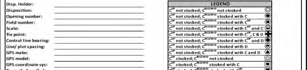
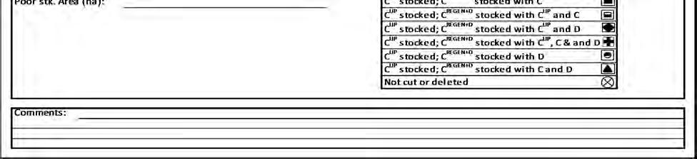
112 Page 112 of 315
113 Opening number: Line Plot UNDERSTORY PROTECTION ESTABLISHMENT SURVEY TALLY SHEET A C UP Stocking Acceptable C UP tree? 1.78 m plot 3.99 m plot C REGEN+D Stocking (1.78m plot) Acceptable C tree? Acceptable D tree? C UP Plot status (3.99m plot) Stocked or Not Stocked C REGEN+D Plot status (1.78m plot) Not stocked or Stocked-C or Stocked-D or Stocked C+D C REGEN+D Plot under height trees* (1.78m plot) UH C Species 15 cm tall UH D Species 30 cm tall *Optional to collect this information. Not to be used in the calculation of C UP or total opening-level stocking for UP openings. Page of Page 113 of 315
114 Opening number: GPS X Corrdinates GPS Y Coordinates UNDERSTORY PROTECTION ESTABLISHMENT SURVEY TALLY SHEET B Plot ID C UP Stocking Acceptable C UP tree? 1.78 m plot 3.99 m plot C REGEN+D Stocking (1.78m plot) Acceptable C tree? Acceptable D tree? C UP Plot status (3.99m plot) Stocked or Not Stocked C REGEN+D Plot status (1.78m plot) Not stocked or Stocked-C or Stocked-D or Stocked C+D C REGEN+D Plot under height trees* (1.78m plot) UH C Species 15 cm tall UH D Species 30 cm tall *Optional to collect this information. Not to be used in the calculation of C UP or total opening-level stocking for UP openings. Page of Page 114 of 315
115 8 Performance survey standard Purpose The Timber Management Regulation (122.1(1) a.1) defines Performance surveys as a survey to determine if established stands have continued to grow and to ensure these stands are healthy, vigorous, and capable of generating yields similar to the post-harvest yields assumed in the timber supply analysis. The Performance survey utilizes two (2) assessment systems to generate Mean Annual Increments (MAI): 1) Aerial Stratification System (Section 8.4); and, 2) Non-photo System (Section 8.5). The Aerial Stratification System is the standard method for Performance surveys. The Non-photo System is only available to obligation holders with a total annual Performance survey program of 250 ha or less within a forest management unit (TSA generally coincident with a FMA or FMU) or as described in Section Aerial Stratification and Non-photo System Performance field surveys shall: Measure density, top height, and age by species; and, Locate poorly regenerated areas (areas greater than 2 ha in size with less than 200 stems per ha). The standard also includes a survey protocol for openings whose current status in the Alberta Regeneration Information System (ARIS) is Conditionally Satisfactorily Restocked (CSR) or Not Satisfactorily Restocked (NSR) to the Deciduous (D) Standard (Section 9). This protocol uses the stocked plot method to determine the stocking status for the opening. Applying a CSR stocking status to an opening as a result of an Establishment survey is no longer valid, effective May 1, Objectives The objectives of the Performance survey are: To assess every opening, as required under the Timber Management Regulation, at performance timing to document the status of the opening; To identify homogeneous units (polygons, Sampling Units) within openings to support model forecasts of Coniferous and Deciduous Mean Annual Increment (MAI) in a manner that is sensitive to the architecture and assumptions of the model used to generate the MAI; Page 115 of 315
116 To support efficient data gathering that will result in accurate regeneration assessment metrics (tree and stand parameters, stand type, MAI); To estimate stand and tree parameters to known and acceptable levels of accuracy; and, To provide data to demonstrate maintenance of minimum forest structures (i.e., identification of poorly regenerated areas). Timing Aerial photography acquisition For those timber disposition holders using the Aerial Stratification System, the following applies: Aerial photography shall be acquired no sooner than 11 years and no later than 14 years after the end of the Timber Year of Cut or clock re-set date or disturbance date. Table 8-1 summarizes the timing requirements for the acquisition of aerial photography and submission of shape files to the department. Table 8-1. Aerial photography acquisition timing and opening eligibility by Timber Year of Cut or clock re-set date or disturbance date. Photo Program Year Timber Year of Cut eligibility N Y a Y Y Y N N N N N N N N N N N N 2012 N N N Y Y Y N N N N N N N N N N N 2013 N N N N Y Y Y N N N N N N N N N N 2014 N N N N N Y Y Y N N N N N N N N N 2015 N N N N N N Y Y Y N N N N N N N N 2016 N N N N N N N Y Y Y N N N N N N N 2017 N N N N N N N N Y Y Y N N N N N N 2018 N N N N N N N N N Y Y Y N N N N N 2019 N N N N N N N N N N Y Y Y N N N N 2020 N N N N N N N N N N N Y Y Y N N N 2021 N N N N N N N N N N N N Y Y Y N N 2022 N N N N N N N N N N N N N Y Y Y N 2023 N N N N N N N N N N N N N N Y Y Y a with approved deferral Y = Openings with harvest dates within the specific Timber Year of Cut are eligible for acquisition of aerial photography for the specified program year. N = Openings with harvest dates within the specific Timber Year of Cut are not eligible for acquisition of aerial photography for the specified program year Y a Y Y Y N N N N N N N N N N N N N For openings with stand tending activities (manual or chemical), aerial photography shall be acquired after all silviculture activities (i.e., stand tending) are completed. This is necessary to ensure Sampling Units within openings are interpreted accurately for species composition and Page 116 of 315
117 density prior to field sampling. Prior written approval from the department is required each year where this requirement cannot be met. Approval may be granted where operational constraints preclude this requirement from being met. In the event that aerial photographs are not acquired due to circumstances beyond the control of the obligation holder and the openings are due for Performance surveys (year 14 in the Performance survey window; Table 8-2), obligation holders shall use the Non-Photo System for these openings. Field survey For openings currently declared to the C, CD, or DC Strata Standards, the following applies: Performance field surveys shall be completed no sooner than 11 years and no later than 14 years after the end of the Timber Year of Cut or clock re-set date or disturbance date (Table 8-2). Table 8-2. Performance field survey timing and opening eligibility by Timber Year of Cut or clock re-set date or disturbance date. Timber Year of field survey Timber Year of Cut eligibility Complete by Report by 2010/2011 Y a Y Y Y N N N N N N N N N N N N N 30 April, May, /2012 N Y a Y Y Y N N N N N N N N N N N N 30 April, May, /2013 N N N Y Y Y N N N N N N N N N N N 30 April, May, /2014 N N N N Y Y Y N N N N N N N N N N 30 April, May, /2015 N N N N N Y Y Y N N N N N N N N N 30 April, May, /2016 N N N N N N Y Y Y N N N N N N N N 30 April, May, /2017 N N N N N N N Y Y Y N N N N N N N 30 April, May, /2018 N N N N N N N N Y Y Y N N N N N N 30 April, May, /2019 N N N N N N N N N Y Y Y N N N N N 30 April, May, /2020 N N N N N N N N N N Y Y Y N N N N 30 April, May, /2021 N N N N N N N N N N N Y Y Y N N N 30 April, May, /2022 N N N N N N N N N N N N Y Y Y N N 30 April, May, /2023 N N N N N N N N N N N N N Y Y Y N 30 April, May, /2024 N N N N N N N N N N N N N N Y Y Y 30 April, May, 2024 a with approved deferral Y = Openings with harvest dates within the specific Timber Year of Cut are eligible for Performance field survey. N = Openings with harvest dates within the specific Timber Year of Cut are not eligible for Performance field survey. For openings currently declared to the D Stratum Standard, the following applies: Where an Establishment survey has been completed for an opening prior to 1 May, 2010 and the opening is deemed Satisfactorily Restocked (SR), a Performance survey is not required. Where an Establishment survey has been completed for an opening prior to 1 May, 2010 and the opening is deemed to be CSR or NSR, a Performance field stocking survey (Section 9) shall be completed no sooner than 8 years and no later than 14 years after the end of the Timber Year of Cut. Where an Establishment survey has not been completed for an opening as of 1 May, 2010, a Performance survey is required to be completed no sooner than 11 years and no later than 14 years after the end of the Timber Year of Cut or clock re-set date or disturbance date. Page 117 of 315
118 For all openings declared to any Regenerated Yield Stratum, the following applies: Performance field surveys shall be completed no sooner than 11 years and no later than 14 years after the end of the Timber Year of Cut or clock re-set date or disturbance date. For openings with stand tending activities, the following applies: Performance field surveys must not be completed within two (2) growing seasons after a manual tending treatment for openings located within the Lower Foothills and Mixedwood Natural Subregions. Performance field surveys may be completed at any time after herbicide treatment provided that the efficacy of the treatment is evident at the time of the survey and the survey is completed within the required period of time (Table 8-2). Aerial Stratification System The Aerial Stratification System is the standard method for completing Performance surveys. The system is designed to support a high level of confidence in polygon-level MAI projections. Timber disposition holders shall sample annual populations of stratified polygons (Sampling Units) to achieve this high level of prediction confidence. The Aerial Stratification System has six (6) distinct and sequential phases: (1) Aerial photography acquisition; (2) Softcopy development; (3) Stratification; (4) Field sample selection; (5) Field survey; and, (6) Compilation and calculation of MAI. The annual population for which MAI projections will be determined shall be those openings submitted for field sample selection. The annual population may contain openings of the same age or different ages but must be from within the Performance survey timing window (Table 8-2) and from within the same TSA generally coincident with a FMA or FMU. Aerial photography acquisition Standards for submission of openings to Alberta Timber disposition holders are responsible for organizing and managing their own aerial photography acquisition programs. The most current spatial layer (AVI or cutblock layer) for the opening shall be used for photo acquisition. For openings harvested on or after May 1, 2016, the requirements under ESRD, Land and Forestry Policy, 2015, No. 3 Final Cutblock Digital Data Submissions apply. These opening boundaries shall be used for photo acquisition subject to the timing requirements under Section 8.3. Page 118 of 315
119 However, in order to facilitate the audit of opening boundaries, original shape files used to identify openings for photo acquisition, in the format described below, must be submitted to the department (Forest Management Branch) as part of the submission package (Section 8.7.6). The standard for submission of shape files to Alberta is geospatial data in the Environmental System Research Institute (ESRI) ARC compatible shape file format. The shape files shall consist of four (4) mandatory files, all of which must be submitted as a cumulative shape file: <filename>.prj The file that stores the coordinate system information. This file is the datum and projection coordinate system for the shape file. (1) The Datum for all shape files shall be North American Datum 1983 (NAD83). (2) The location coordinate system for all shape files shall be Universal Transverse Mercator (UTM Zone 11 or 12) projection (easting and northing) in meters. <filename>.shp <filename>.shx <filename>.dbf The main file that stores the geometry of the polygon; The file that stores the index of the polygon s geometry; The dbase table that stores the attribute information of the polygon. There shall be a one-to-one relationship between geometry and attributes. Attribute records in the dbase file must be in the same order as records in the main file. The attribute file shall contain the field names and associated information described in Appendix 10, Table Original shape files shall accompany the Performance survey annual reporting package submitted to the Forest Management Branch by 15 May. Standards for aerial photography The Standards for the acquisition of aerial photography shall follow the General Specifications for Acquiring Aerial Photography (March 2014) 15. For conventional aerial photography: The scale of aerial photography shall be 1:20,000 or larger; Aerial photography shall be acquired as stereo pairs; and, The preferred film is True Color. For digital aerial photography: 15 Page 119 of 315
120 Images must meet or exceed a 20 cm digital direct, 4 band (RGB) resolution captured with IMU/GPS. The preferred season of photography is spring leaf-off. Effective 1 May, 2014, aerial photography acquired for the purpose of Performance surveys must be digital and to the standard described in the RSA. Conventional aerial photography acquired on or after 1 May, 2014 and used for Performance surveys will not be acceptable. Process for distributing negatives Repealed 1 May, Softcopy development Scanning Standards The Standard for scanning negatives shall be the General Specifications for Acquiring Aerial Photography. The scanning resolution for 1:20,000 scale photography shall be 15 microns or higher. If larger-scale photography is acquired, then the scanning resolution shall be modified accordingly. Timber disposition holders who have returned negatives to Alberta for storage may request access at any time for a period of five (5) years. Alberta will permit access to the negatives providing the timber disposition holder making the request has openings on the roll of film. After the five year period, Alberta will contact timber disposition holders to determine whether to return or destroy the negatives. Aerial triangulation standards The Standard for aerial triangulation shall be the General Specifications for Acquiring Aerial Photography. Softcopy development requires Digital Elevations Models (DEM). Timber disposition holders shall be responsible for obtaining appropriate DEM. DEM data (i.e., ArcInfo GRIS 25 meter) may be obtained from the Data Distribution Unit, Informatics Branch, Environment and Parks. Stratification Stratification of openings is a key first step for Performance surveys. The objectives of stratification are: To delineate homogeneous strata (Sampling Units) within openings to increase sampling precision; and, To identify Poorly Regenerated Areas. The general stratification procedure shall be: Page 120 of 315
121 (1) Delineate the Net Assessment Area (NAA) by netting-out land use and/or natural deletions (Section ); (2) Stratify the NAA into Sampling Units (Section ); and, (3) Stratify the NAA into Poorly Regenerated Areas (Section ). Delineating Sampling Units and Poorly Regenerated Areas are separate exercises: Exercise 1: NAA Delineate Sampling Units Exercise 2: NAA Delineate Poorly Regenerated Areas Two separate shape files are required, one for each exercise. Poorly Regenerated Areas may overlap with more than one Sampling Unit Opening boundaries Stratification shall be completed within opening boundaries. Ensuring that opening boundaries are complete and accurate is a fundamental requirement of RSA. For openings harvested on or after May 1, 2016 and to meet the requirements under ESRD, Land and Forestry Policy, 2015, No. 3 Final Cutblock Digital Data Submissions, opening boundaries shall not be re-drawn except where land use deletions have occurred. There may be instances where the shape file boundaries do not line up with the softcopy image either because the opening boundary appears to have shifted or portions of the opening boundary appear to be incorrect (e.g., un-harvested areas within the opening boundaries, harvested areas that are clearly part of the opening but outside of the boundary). Interpreters shall use the following guidelines when re-drawing opening boundaries: Where the opening boundary appears to have shifted, the opening boundary shall be redrawn. Where portions of the opening boundary appear to include areas of un-harvested trees from an adjacent mature stand, the opening boundary shall be re-drawn to exclude those portions. Where portions of the opening boundary appear to exclude harvested areas which are clearly part of the opening, the opening boundary shall be re-drawn to include those portions. Where portions of the opening boundary appear to either include or exclude harvested areas which may or may not be part of the opening, care must be taken to ensure the adjacent area is actually part of the original harvest. This situation may occur where two openings of similar age are adjacent to one another. Similarly, where the opening is adjacent to an area without trees, care must be taken to not be removing Poorly Page 121 of 315

122 Regenerated Areas that appear to not fit the remainder of the harvested area. Interpreters shall consult with timber disposition holders to obtain more information before any changes are made. Where land use dispositions straddle opening boundaries, the opening boundaries shall not be re-drawn. The portions of the land use within openings shall be netted out using the methods described in Section Other spatial layers (e.g., AVI layer, complete opening layer) shall be used to assist interpreters with re-drawing opening boundaries. Overlap of opening boundaries within and among timber dispositions or land use dispositions is not permitted (Figure 8-1). Conversely, areas clearly harvested and associated with two or more openings but not part of any opening are not permitted. These types of boundary issues found as a result of an audit completed by the department will result in the entire performance survey program being deemed unacceptable. Subdivision of openings due to these boundary issues will not be permitted. overlap Area clearly harvested but not within any opening boundary Figure 8-1. Example of opening boundary overlap (in yellow) and area clearly harvested but not within any opening boundary. Opening boundaries that cross administrative units (FMA or FMU with different forest management plans) shall be re-drawn to correspond with the administrative unit boundary. This is necessary because there are specific forest management assumptions associated with each administrative unit. Page 122 of 315
123 Where boundaries have been re-drawn, interpreters shall document, on an opening by opening basis, their justification for the new opening boundaries together with the area difference between the boundary area supplied by the timber disposition holder and the re-drawn boundary area. Only include those openings where the boundary area changes are greater than 0.5 ha or 5%, whichever is smaller. The documentation and rationale are necessary for audit purposes and shall be included in the Performance Survey Summary Report (Section ). Recording administrative information Interpreters shall record information on imagery, interpretation, and unique polygon identifiers for Sampling Units and poorly regenerated areas. A data dictionary is provided in Appendix 11, Table 11-7 (Interp1). References to applicable field names are provided in the following text Imagery Interpreters shall record the date the image was captured, image emulsion, scale of photography, and the season (leaf-off or leaf-on) the image was acquired. When recording imagery information, the applicable fields are PHOTO_Y, PHOTO_M, PHOTO_D, EMULSION, SCALE, and LEAF Interpretation Interpreters shall record the year and month of interpretation and their full name (first name first then surname). When recording interpretation information, the applicable fields are INTRP_Y, INTRP_M, and INTRP Unique polygon identifier The interpreter shall record the opening number, polygon number, unique identifier, and area in hectares for each polygon. Each netted out land use disposition and/or natural deletion, delineated Sampling Unit, and Poorly Regenerated Area shall be assigned a unique polygon number. For example, if an opening has one netted out natural deletion, two Sampling Units, and one Poorly Regenerated Area, then there shall be four (4) unique polygon numbers. When recording unique polygon identifier information, the applicable fields are OPENING, POLYGON, UNIQUE_ID, and AREA_HA. Higher-level stratification In order to capture known or anticipated significant differences in stand characteristics and/or performance, a higher-level of stratification of openings for sampling may be necessary. Use of higher-level stratification is at the discretion of each timber disposition holder (i.e., optional). There is one exception. Higher-level stratification is required for Enhance Forest Management (EFM) (see below). However, higher-level stratification should be utilized where timber disposition holders wish to enhance the accuracy of the MAI forecast. Silviculture treatments (e.g. manual, chemical, non-tending activities) or geographic growing conditions (e.g. Lower Foothills Natural Subregion versus Upper Foothills Natural Subregion) are examples of higher-level stratification. Page 123 of 315
124 Where higher level of stratification is used, the information must be recorded and the appropriate code (timber disposition holder defined) assigned to each Sampling Unit in the population Enhanced Forest Management Enhanced Forest Management (EFM) is defined as improvement to forest growth resulting from thinning, fertilization, tree improvement or drainage 16. Area (ha) deemed EFM must be sampled as its own population and specific to each type of EFM. Specifically for the EFM tree improvement type, Openings with either an AIC9 or AIC11 genetic classification code in ARIS shall contribute to the EFM tree improvement type population; and, Openings where 50% of the area was bare ground planted and 70% of seedlings planted are from seed lot(s) deemed improved seed shall contribute to the EFM tree improvement type population; and, Spatially known (shape file, map) portions of openings where 70% of seedlings bare ground planted are from seed lot(s) deemed improved shall contribute to the EFM tree improvement type population. Timing and submission of planting of genetically improved stock spatial information associated with ESRD, Land and Forestry Policy, 2015, No. 4 Silvicultural Activities Digital Data Submission shall also be used to fulfil this requirement. Bare ground planting refers to planting activities that meet the two year treatment rule under Section 141.1(1) of the Timber Management Regulation. All other requirements for defining populations (Section ) and Sample Unit size (Section ) apply. Delineating the Net Assessment Area (Field NAA ) In most cases, land use dispositions and natural deletions will have been netted out of the opening area by the timber disposition holder prior to the stratification process. Where land use dispositions and natural deletions (Table 8-3) have not been netted out of the opening, interpreters shall remove these features using the following guidelines: Land use dispositions that have resulted in landbase with-drawls shall be netted out, regardless of size, status of clearing or extent of re-vegetation. Natural deletions 0.5 ha in size, regardless of width, shall be netted out. Where the spatial layer containing land use dispositions or natural deletions has shifted, the boundaries shall be re-drawn. 16 Alberta Sustainable Resource Development, Alberta Forest Management Planning Standard. Version 4.1 April For a digital copy of this document, visit the AAF website (forestry.alberta.ca) and use the following search term: Alberta Forest Management Planning Standard. Page 124 of 315
125 Interpreters shall use the most current information when netting out land use. For example, the spatial land use layer may be dated. Interpreters may use other more current sources of documentation to assist with netting out land use dispositions. For audit purposes, these other sources of information, when used, shall be retained and made available to Alberta upon request. Each net down polygon shall be assigned a unique number (Field POLYGON ). A code shall be assigned to polygons delineated and removed from the opening (Table 8-3) (Field NAA ). The area remaining within the opening after the net down process defines the NAA. The NAA within an opening shall be stratified by interpreters. Unique numbers (Field POLYGON ) shall be assigned to delineated polygons within the NAA. Table 8-3. Net Assessment Area, anthropogenic and natural deletion codes. Category Code Description Net Assessment Area 0 Net Assessment Area Anthropogenic 1 Any of: MLL Miscellaneous Lease (campsite, sand and gravel, etc.) PLA Pipeline Agreement LOC Licence of Occupation Road Well site Archaeological and historic sites Permanent sample plots or other research areas (covered under a protective notation) Natural 2 Riparian areas and uncut buffers (0.5 ha or larger) Uncut patches within the opening (0.5 ha or larger) Stratifying the Net Assessment Area into Sampling Units Interpreters shall stratify the NAA into homogeneous areas, called Sampling Units, by considering the regeneration layer only. The regeneration layer is the primary layer of regenerating trees that contributes to reforestation performance. This layer includes seedlings, suckers, and advanced growth (e.g., conifer understory avoidance) Silviculture records and field calibration Timber disposition holders shall provide silviculture records to interpreters. The purpose of silviculture records is to assist interpreters with making informed decisions when delineating and assigning attributes to polygons. Silviculture records may include: Page 125 of 315
126 Site preparation type and extent; Planting (species, stock type, density, extent or leave for natural); Establishment survey results; and, Stand tending activities. Interpreters shall undertake field calibration. Field visitation by interpreters to a subset of openings is necessary in order to calibrate or confirm species identification, species composition, and/or density. Interpreters may establish plots and collect data or simply walk-through the opening. The amount of field verification may vary, but must be sufficient to enable interpreters to make reasonable and consistent interpretations Tree species composition and density classes Delineation of Sampling Units within the regeneration layer shall be based on tree species composition and density classes. Table 8-4 describes the ten (10) tree species composition classes. These tree species composition classes correspond with the standardized stratification for yield estimates, as described in the Alberta Forest Management Planning Standard (SRD 2006) 17. Tree species proportions used to define tree species composition classes are based on interpreted tree species density (i.e., stems per ha). 17 Alberta Sustainable Resource Development, Alberta Forest Management Planning Standard. Version 4.1 April For a digital copy of this document, visit the AAF website (forestry.alberta.ca) and use the following search term: Alberta Forest Management Planning Standard. Page 126 of 315
127 Table 8-4. Tree species composition class definitions. Tree species composition class Coniferous tree percent (density based) Hw 0-20 NA HwPl Pine HwSx Spruce SwHw White spruce PlHw Pine SbHw Black spruce Sw White spruce Pl Pine Sb Black spruce Fd Douglas-fir Leading coniferous tree species (density based) Pine = Pl, Pj, Pw, Pf, Lt, La, Lw; Spruce = Sw, Sb, Se, Fb, Fa; White spruce = Sw, Se, Fb, Fa; Black spruce = Sb; Hardwood = Aw, Pb, Bw; Douglas-fir = Fd If the species proportions are 50% coniferous trees and 50% deciduous trees, then use the order of tree species to determine which has the higher density to differentiate coniferous tree leading mixedwood or deciduous tree leading mixedwood. Table 8-5 describes the four (4) density classes. These density classes represent the relative sensitivity in model forecast culmination MAI. For example, where MAI is more sensitive to change in density, the range within the density class is less. Density classes are defined as the total stems per hectare of trees in the regeneration layer. Table 8-5. Density class definitions. Density class Code Density range (stems per ha) Low L 1 1,000 Medium M 1,001 2,000 High H 2,001 5,000 Dense D >5, Stratification standard Interpreters shall stratify the regeneration layer of the NAA into Sampling Units based on species composition and density classes to the following standards: Page 127 of 315
128 Sampling Units shall not be delineated when smaller than two (2.0) hectares. Sampling Unit widths at any point shall not be less than 50 meters. Stratification shall be hierarchical. o Step 1: Stratify the regeneration layer within the NAA based on species composition: Where tree species composition class (Table 8-4) differs; and Where the tree species composition percentage of a single species within the cover type differ by more than 10%; and, Where the Sampling Unit size (minimum 2 ha) and width (minimum 50 m) criteria are met. Box 15. Stratifying the regeneration layer based on tree species composition. Aw7Sw3/Aw8Sw2 (criterion 2 not met) Aw6Sw4/Aw8Sw2 (all criteria met) Aw6Sw4/Aw7Sw3 (criteria 1 and 2 not met) Pj5Aw4Sb1/Aw5Pj5 (criterion 2 not met) Pl6Aw2Sw2/Pl7Aw3 (criterion 2 not met) Sw5Pl5/Pl6Sw4 (criterion 2 not met) Pl5Aw4Sb1/Aw6Pl4 (all criteria met) Pl6Aw2Sw2/Pl6Aw4 (all criteria met) Sw8Pl2/Pl5Sw4Aw1 (all criteria met) Aw10/Sw10 (all criteria met) o Step 2: Stratify the regeneration layer within the NAA based on density: Where total density class (Table 8-5) differs; and, Where total density differs by more than 25% (tolerances are defined in Table 8-6); and, Where the Sampling Unit size (minimum 2 ha) and width (minimum 50 m) criteria are met. Page 128 of 315
129 Table 8-6. Adjacent density class tolerances. Adjacent density classes Density class transition tolerance (stems per ha) Low and Medium 250 Medium and High 500 High and Dense 1,250 o Step 3: As described in Section , characterize each Sampling Unit for: Average height; Spatial distribution; Mixedwood pattern; and, Residual layer Average height, spatial distribution, mixedwood pattern, and residual layer shall not contribute to Sampling Unit delineation, but rather are required attributes which characterize the Sampling Unit. Interpreters shall only identify and attribute residual layers where crown closure exceeds 15% across the Sampling Unit. Crown closure is either inferred from stem counts in the leaf-off condition or directly where leaf-on aerial photography has been acquired. Residual areas that have been netted out (i.e., excluded from the NAA) shall not be characterized. Examples of netting down openings and hierarchical delineation of Sampling Units are provided in Appendix Recording Sampling Unit attribute information For each Sampling Unit, interpreters shall record attribute information for regeneration layer species composition, density, average height, spatial distribution, mixedwood pattern, and residual layer species composition, density, and average height. A data dictionary for Sampling Units is provided in Appendix 11, Table 11-7 (Interp1). References to applicable field names are provided in the following text Regeneration layer species composition Species composition is based on interpreted species density (i.e., stems per ha) and recorded to the nearest 10%. Eligible tree species codes are listed in Table 8-7. Tree species present within a Sampling Unit shall be recorded in decreasing order of occurrence based on density. For example, if a regeneration layer density is composed of 54% Sw, 26% Aw, and 20% Pl, then the Sampling Unit would be labelled Sw5Aw3Pl2. Page 129 of 315
130 Where a Sampling Unit has two or more species of the same density class, the order shall be based on the species which is interpreted to have the greater absolute density. When recording regeneration layer species composition information, the applicable fields are SP1, SP1_PER, SP2, SP2_PER, SP3, SP3_PER, SP4, SP4_PER, SP5, SP5_PER, SP_CL. Table 8-7. List of tree species names and associated codes. Tree species Interpretation and database codes Common name Scientific name Specific code Generalized code White spruce Picea glauca (Moench) Voss 1 Sw Sw Engelmann spruce Picea engelmannii Parry ex Engel. Se Sw Black spruce Picea mariana (Mill.) BSP Sb Sb Lodgepole pine Pinus contorta Dougl. Ex Loud. var. latifolia Engelm. Jack pine Pinus banksiana Lamb. Pj P Whitebark pine Pinus albicaulis Engelm. Pw P Limber pine Pinus flexilis James Pf P Balsam fir Abies balsamea (L.) Fb Fb Subalpine fir Abies lasiocarpa (Hook.) Nutt. Fa Fb Douglas-fir Pseudotsuga menziesii (Mirb.) Fd Fd Subalpine larch Larix lyallii Parl. La Lt Tamarack Larix laricina (du Roi) K.Koch Lt Lt Western larch Larix occidentalis Nutt. Lw Lt Trembling aspen Populus tremuloides Michx. Aw A Balsam poplar Populus balsamifera L. Pb A Paper birch Betula papyrifera Marsh. Bw Bw 1 Nomenclature follows Farrar, J.L. Trees in Canada. Fitzhenry & Whiteside Limited and the Canadian Forest Service, Markham, Ontario. 502 p. Pl P Regeneration layer total density Total density is the density of all tree species in the regeneration layer of the Sampling Unit. The units for total density are stems per ha. Total density shall be recorded as a numeric field to the nearest 50 stems per ha. Density class shall be recorded. Page 130 of 315
131 When recording regeneration layer total density information, the applicable fields are DENSITY and DEN_CL Regeneration layer average height Average height is the average height of the dominant and co-dominant trees of the regeneration layer. The purpose of interpreting average height for the regeneration layer is to describe the sampling population. For example, average height may be used to determine if the Sampling Units selected for field survey appear to be outlier samples. Average height for each Sampling Unit shall be recorded to the nearest 0.5 meters. When recording regeneration layer average height information, the applicable field is AVE_HT Regeneration layer spatial distribution The spatial distribution of stems across the Sampling Unit is described using the tree distribution pattern code, as outlined in Table 8-8. The spatial distribution only includes tree stems in the regeneration layer. A tree distribution pattern shall be assigned to each Sampling Unit. Interpreting the spatial distribution of trees for the regeneration layer is analogous to assessing stocking. The applicable field is SPATIAL when recording regeneration layer spatial distribution information. Page 131 of 315
132 Table 8-8. Spatial distribution codes and descriptions. Description Map label Database code Example Single to very few (1-3) occurrences of trees covering <10% of the area of the Sampling Unit. P1 1 Several ( 4) sporadic occurrences of trees covering < 30% of the area of the Sampling Unit. Intimately intermixed units, often with gradational transitions from one to another. The trees cover 30% to 50% of the area of the Sampling Unit. Continuous occurrences with several gaps. 51% - 79% of the Sampling Unit area has trees. P2 2 P3 3 P4 4 Continuous occurrence ( 80%) throughout the Sampling Unit area with very few gaps. P Regeneration layer mixedwood pattern A mixedwood pattern code is a qualitative measure describing the level of intermixing of coniferous and deciduous components within a Sampling Unit. It provides information on the relative spatial orientation of stand components to a scale more detailed than the minimum Sampling Unit dimensions. This metric indicates the types of mixedwoods in each Sampling Unit. A mixedwood pattern code must be assigned to each Sampling Unit. The applicable field is MIXED when recording regeneration layer mixedwood pattern information. The mixedwood pattern of the regeneration layer is a metric of the operational maintenance of the range of mixedwood types (e.g., intimate, aggregate, or segregate). The mixedwood pattern code is defined from the perspective of the coniferous tree within the Sampling Unit. The more coniferous trees occur in the presence of deciduous trees, the more intimate the mixture. The more coniferous trees occur in the absence of deciduous trees, the more aggregate the mixture. Page 132 of 315
133 When both coniferous and deciduous tree species are listed in the detailed species composition, the mixedwood pattern code must be either intimate or aggregate. For example, if the label for the Sampling Unit is Aw9Sw1, then mixedwood pattern cannot be equal to P (pure). One of the following mixedwood patterns codes must be assigned to each Sampling Unit: Intimate Intimate shall be recorded when the majority of area occupied by coniferous tree stems occur in patches 18 in the presence of significant numbers of deciduous tree stems. A significant number of deciduous tree stems is considered to be approximately 200 stems per ha. The eligible code is I. Aggregate Pure Aggregate shall be recorded when the majority of area occupied by coniferous tree stems occur in patches in the absence of significant numbers of deciduous tree stems. The eligible code is A. Pure shall be recorded when coniferous or deciduous tree species composition is 10 (100%) (e.g. Sw10, Sw7Pl3, and Aw7Pb3). The eligible code is P. The relative scale that interpreters should use when determining the mixedwood pattern code is 0.25 hectares. Figure 8-2 is a graphic that shows the various levels of intermixing and associated gradients that should be considered. The graphic also provides a general scale for interpreters to consider when making the mixedwood pattern call. The green dots represent coniferous trees while the orange dots represent deciduous trees. This graphic is intended to be supporting rationale for how a mixedwood pattern call can be made. In general, interpreters should visually scan the Sampling Unit with these concepts in mind and assign a mixedwood pattern code based on the estimated level of intermixing. Additional description and interpretation on making a mixedwood pattern call is provided in Appendix Patches considered as part of the mixedwood pattern call should be approximately a quarter hectare in size or larger. Page 133 of 315


 and recorded to the nearest 10%")
134 Figure 8-2. Mixedwood pattern Residual layer species composition The purpose of interpreting the residual layer is to document the amount of residual trees in each Sampling Unit. This is necessary because the residual layer may impact the regeneration layer. Interpreters shall only identify and attribute residual layers where crown closure exceeds 15% across the Sampling Unit. Crown closure is either inferred from stem counts in the leaf-off condition or directly where leaf-on aerial photography has been acquired. Species composition is based on interpreted species density (i.e., stems per ha) and recorded to the nearest 10% class. Eligible tree species codes are listed in Table 8-7. Page 134 of 315
135 Tree species present within a Sampling Unit shall be recorded in decreasing order of occurrence based on density. For example, if a residual layer is composed of 54% Sw, 26% Aw, and 20% Pl, then the Sampling Unit is labelled Sw5Aw3Pl2. Where a Sampling Unit has two or more species of the same density class, the order shall be based on the species which is interpreted to have the greater absolute density. When recording residual layer species composition information, the applicable fields are R_SP1, R_SP1_PER, R_SP2, R_SP2_PER, R_SP3, and R_SP3_PER Residual layer total density Total density is the density of all tree species in the residual layer of the Sampling Unit. The units for total density are stems per ha. Total density shall be recorded as a numeric field to the nearest 50 stems per ha. When recording residual layer total density information, the applicable field is R_DEN Residual layer crown closure Residual layer crown closure refers to the ground area (expressed as a percentage of the total Sampling Unit area) covered by a vertical projection of tree crowns onto the ground. Crown closure is recorded as a numeric field to the nearest 10% specific to the residual layer. The applicable field is R_CC when recording residual layer crown closure information Residual layer average height Average height is the average height of the dominant and co-dominant trees of the residual layer. Average height for each Sampling Unit shall be recorded to the nearest 0.5 meters. When recording residual layer average height information, the applicable field is R_AVE_HT Residual layer spatial distribution The spatial distribution of residual stems across the Sampling Unit is described using the tree distribution pattern code, as outlined in Table 8-8. Note that the spatial distribution includes all tree stems in the residual layer. A tree distribution pattern shall be assigned to each Sampling Unit. The applicable field is R_SPT when recording residual layer spatial distribution information Assessment of stocking (optional) The assessment of stocking is optional. Stocking information is being collected to aide in understanding the interpreted stratum call (in contrast to density) compared with the ground plot data at the stratum-level. For each Sampling Unit, interpreters shall record attribute information for regeneration layer species composition and stocking. Stocking shall be assessed in a manner that replicates mil hectare plots in a systematic grid across the entire Sampling Unit. A data dictionary for Sampling Page 135 of 315
136 Units is provided in Appendix 11, Table 11-9 (Interp3). References to applicable field names are provided in the following text. The Interp3 dataset shall not imported into the RSA Compiler. Species composition is based on interpreted tree species group stocking (i.e., in a manner that is equivalent to mil hectare plots systematically distributed across the Sample Unit; similar plot intensity as the Establishment Intensive survey) and recorded to the nearest 10%. Eligible tree species group codes are AW, PL, SB, and SW. Tree species groups present within a Sampling Unit shall be recorded in decreasing order of occurrence based on stocking. For example, if a regeneration layer stocking is composed of 84% SW, 36% AW, and 20% PL, then the Sampling Unit would be labelled SW8AW4PL2. Where a Sampling Unit has two or more species groups of the same stocking, the order shall be based on the species group which is interpreted to have the greater absolute density. When recording regeneration layer species composition information, the applicable fields are PS_SG1, PS_SG1_PER, PS_SG2, PS_SG2_PER, PS_SG3, PS_SG3_PER, PS_SG4, PS_SG4_PER, and PS_SG_CL Regeneration layer coniferous, deciduous and total stocking Coniferous stocking is the stocking of all coniferous tree species groups (PL, SB, and SW) in the regeneration layer of the Sampling Unit. The unit for coniferous stocking is percent. Coniferous stocking shall be recorded as a numeric field to the nearest 1%. Coniferous stocking shall not exceed 100%. When recording regeneration layer coniferous stocking information, the applicable field is PS_CON. Total stocking is the stocking of all tree species groups (AW, PL, SB, and SW) in the regeneration layer of the Sampling Unit. The unit for total stocking is percent. Total stocking shall be recorded as a numeric field to the nearest 1%. Total stocking shall not exceed 100%. When recording regeneration layer total stocking information, the applicable field is PS_TOTAL. Stratifying the Net Assessment Area for Poorly Regenerated Areas A Poorly Regenerated Area is defined as an area within an opening that is greater than two (2) hectares in size with a total density of less than 200 stems per ha. All tree species present in the Poorly Regenerated Area (regeneration layer only) shall be considered when delineating and attributing the polygon. Delineating Poorly Regenerated Areas shall be an independent exercise relative to the delineation of Sampling Units Stratification standards Interpreters shall delineate Poorly Regenerated Areas within the NAA to the following standards: Poorly Regenerated Areas shall not be delineated when smaller than two (2.0) hectares. Page 136 of 315
137 Widths of poorly regenerated areas at any point shall not be less than 50 meters. Interpreters shall use the NAA within each opening to delineate and characterize Poorly Regenerated Areas. Poorly Regenerated Areas shall be interpreted for: Species composition; Total density; and, Average height Recording Poorly Regenerated Area attribute information For each Poorly Regenerated Area, interpreters shall record attribute information including species composition, total density, and average height. A data dictionary is provided in Appendix 11, Table 11-8 (Interp2) Poorly Regenerated Area species composition Where trees are present, species composition must be determined for the Poorly Regenerated Area polygon. Species composition is based on interpreted species density (i.e., stems per ha) and recorded to the nearest 10% class. Eligible tree species codes are listed in Table 8-7. Tree species present within a Poorly Regenerated Area polygon shall be recorded in decreasing order of occurrence based on density. For example, if a Poorly Regenerated Area density is composed of 54% Sw, 26% Aw, and 20% Pl, then the polygon would be labelled Sw5Aw3Pl2. Where a Poorly Regenerated Area polygon has two or more species of the same density class, the order shall be based on the species which is interpreted to have the greater absolute density. When recording poorly regenerated area species composition information, the applicable fields are PR_SP1, PR_SP1_PER, PR_SP2, PR_SP2_PER, PR_SP3, PR_SP3_PER, and PR_SP_CL Poorly Regenerated Area total density Total density is the density of all tree species in the Poorly Regenerated Area polygon. The units for total density are stems per ha. Total density shall be recorded as a numeric field to the nearest 50 stems per ha. When recording Poorly Regenerated Area total density information, the applicable field is PR_DEN Poorly Regenerated Area average height Average height is the average height of the dominant and co-dominant trees of the Poorly Regenerated Area polygon. Average height for each Poorly Regenerated Area polygon shall be recorded to the nearest 0.5 meters. Page 137 of 315
138 When recording Poorly Regenerated Area average height information, the applicable field is PR_AVE_HT. Standardized attribute data dictionary A standardized data format must be used to record polygon attributes. The field names, formats, descriptions and allowable codes are provided in Appendix 11, Table 11-7 (Sampling Units, Interp 1) and Table 11-8 (poorly regenerated areas; Interp2). Field names, formats, descriptions and allowable codes for optional Sample Unit stocking assessment are provided in Appendix 11, Table 11-9 (stocking, Interp 3). Attributes shall be recorded in a flat file format with one row per polygon. Spatial data format standards The format for the spatial data (stratification line-work) shall be in Environmental System Research Institute (ESRI ) Arc compatible format. The acceptable formats are: Shape file (*.shp, *.shx, *.dbf, *.prj); Geodatabase. Spatial data shall be submitted in the North American Datum 1983 (NAD83) in the appropriate projection system: UTM Zone 11N or UTM Zone 12N in metres. Where opening data spans a UTM zone boundary, the data shall be referenced to the zone in which the majority of the feature occurs unless the feature extends more than 0.5 km into the other zone. Where this occurs, the data should be divided into distinct datasets within its own projection zone. Stratification quality assessment and control procedures See Section 10. Sample design for field surveys Following the net-down of openings (i.e., removal of land use dispositions and natural deletions), stratification of Net Assessment Areas (NAA) into Sampling Units, and delineation of Poorly Regenerated Areas, and audit, Sampling Units shall be selected for field sampling. Guiding principles for development of the sample design The guiding principles used to develop the sample design are: The sample design must provide an unbiased representation of each stratum population for which the sampling results are to be applied. All Sampling Units within a stratum population shall have equal probability of being selected for sampling (stratified random sampling). Minimum sample requirements. o The design shall adequately sample strata to meet or exceed minimum sample sizes (i.e., number of Sampling Units) based on the understanding of previously observed variations and desired allowable error targets. Page 138 of 315
139 o The sample design shall select openings until each stratum has reached its minimum sample size (i.e., number of Sampling Units) or all Sampling Units for a stratum have been selected. Defining the population of openings for sampling For the Aerial Stratification System, the population is defined as: Openings within a forest management unit (TSA generally coincident with a FMA or FMU); and, Openings eligible for Performance survey, as defined in Section 8.3; and, Openings for which aerial photography has been acquired; and, Openings that have been stratified, as described in Section 8.4.3; and, Openings submitted to the Sample Selection Tool (v a). Prior to submitting openings to the Sample Selection Tool, the population of openings shall be defined using the Master Opening List (Appendix 14, Table 11-9, Opening1). Sample design input requirements The sample design requires the delineation and interpretation of Sampling Units to the higher stratification (if applicable), tree species composition, and density class levels. However, the sample design shall select Sampling Units from the higher-level strata (if applicable) and from as many of the tree species composition strata as were identified (as defined in Section ). Therefore, the sampling strata are defined by both the high-level stratification (if applicable) and tree species composition. The Sampling Unit selection process uses the sampling strata as the basis for field sampling. Input into the sample selection process must be standardized. The input is the Sampling Unit attributes generated from the stratification process (Section 8.4.3). Standardized formats for Sampling Unit attributes are described in Appendix 11, Table 11-7 (Interp1). Rare strata standards Repealed 1 May, Sample design Sample design: 2010 to 2016 The sample design originally developed for RSA was based on data collected from the 2008 ARS Pilot Projects. This design randomly selected a minimum number of Sampling Units (10 for Hw and Sw and 15 for HwPl, HwSx, SwHw, PlHw, SbHw, Pl, Sb, and Fd strata) from a defined population for field sampling. This sample design assumed an average program (i.e., population of openings) size of approximately 2,000 ha. Sample design: effective May 1, 2016 Page 139 of 315
140 A recently completed review of RSA performance survey programs found that 35% of programs completed since the new reforestation standard s inception on May 1, 2010 are larger than 2,000 ha. This is not a large proportion; however, the risk is that these larger programs represent 82% of the area (ha) assessed for performance surveys. Thus, the area being assessed in the field is relatively small and may not be representative of the area over which MAI estimates are applied. In addition, the RSA review determined that 66% of strata large enough to subsample have >10% error in MAI estimates. Since the fixed sample sizes by tree species composition stratum were strongly favouring large programs and resulting in >10% error in the MAI estimate over a large area, a new sample design is necessary to control the MAI error in a performance survey program. The objective of the sample design for the Aerial Stratification System is a 5% allowable error in the MAI estimate for the primary tree species of management (coniferous or deciduous) by tree species composition stratum across a 5-year period or quadrant. This period was selected as it coincides with the population of openings assessed to determine the level of success in achieving the desired future forest condition (i.e., growth and stratum reconciliation). In order to achieve this 5% allowable error by tree species composition stratum across a quadrant, the allowable error by stratum is 12% within a performance survey program. In other words, if each performance survey program samples each stratum to achieve a 12% allowable error, then it is anticipated that a sufficient number of Sample Units will be field sampled over a 5-year period to achieve a 5% allowable error. Stratified random sampling is used to select Sampling Units for field sampling. In stratified random sampling, the population of openings are stratified based on tree species composition and density (see Section ) to create Sample Units. The Sample Units are selected for field sampling based on tree species composition by choosing random SUs within each stratum, independent of other strata. The finite sample size equation is used to determine the sample size needed to achieve the 12% target error in stratum MAI. N N % where, n = sample size t = Student s t value with a probability of 0.05 and n 1 degrees of freedom CV = weighted coefficient of variation (%) by stratum (Table 8-10) N = program population size %AE = allowable error (12% for each stratum within a program). The CV is the typical variation in MAI relative to its mean for each stratum, and standard CV values were set based on a review of previous RSA submissions. Past coniferous and deciduous MAIs were obtained from previous programs and then weighted by the number of SUs to account for the size of the program. Selection of CV was the 75 th percentile of the observed CVs within each stratum (Table 8-9). The MAI of the primary species of management (coniferous MAI or deciduous MAI) was used for calculating CV, except in the mixedwood strata where the higher CV (the higher variation in coniferous MAI or deciduous MAI) was selected. Lastly, Page 140 of 315
141 since the strata CV values grouped into similar values for pure and for mixedwood strata, an aggregate CV was chosen for each group to form the standard to use in the sample size equation. Table 8-9. The weighted coefficient of variation (CV) standard by coniferous (C) and deciduous (D) MAI selection priority. Species composition strata CV selection priority Weighted CV % CV (%) standard Hw D MAI HwPl D MAI HwSx D MAI SwHw D MAI PlHw D MAI SbHw D MAI Sw C MAI Pl C MAI Sb C MAI Fd C MAI 26 This sampling scheme and CV (%) standards have been incorporated into the Sample Selection Tool (v a). Field sample selection computer program Alberta has developed a Sample Selection Tool (v a) and an associated User s Manual to facilitate the field sample selection process. The Sample Selection Tool (v a) is the standard for selecting Sampling Units for Performance field survey. The Sample Selection Tool (v a) and associated User s Manual are available for viewing and/or downloading by visiting the AAF website (forestry.alberta.ca) and using the following search term:. The Sample Selection Tool (v a) requires standardized inputs (e.g., Interp1 Sampling Unit attribute data, Appendix 11, Table 11-7), conducts a validation on critical fields in the input dataset, generates population statistics, conducts the sample selection based on predetermined random seeds, and produces a standardized output. Field sample inclusion probability The sample design for selecting Sample Units for field sampling uses stratified random sampling. With stratified random sampling each Sample Unit has an equal probability of selection. Thus, Page 141 of 315
142 The inclusion probability for each Sampling Unit and area are necessary for compiling MAI results; Clicking the Calculate Inclusion Probabilities button under Sample Selection in the Sample Selection Tool is still required; The inclusion probabilities are set to one (1) in all cases; and, Running the Monte Carlo simulation is no longer required. Allocating field plots to Sampling Units Guiding principles The guiding principles used to develop the field plot allocation rules are: The method for determining plot locations must be systematic, unbiased, and designed to simplify field layout within and across Sampling Units in openings. The sample intensity must obtain an estimate of model input variables. The method should have a mechanism to sub-sample large Sampling Units as the incremental value of additional plots diminishes as the sample size increases. Combination of two sample intensities (Figure 8-3) shall be used to achieve the minimum and maximum number of plots to establish in each selected Sampling Unit (Table 8-10). The two sample intensities are based on two grid sizes: 50 m 50 m; and, 25 m 25 m. 50m 25m 50m 25m Figure 8-3. Sampling Unit Performance field survey sample intensities. The grid shall be initiated using randomly selected x and y coordinates. Page 142 of 315
143 Table Sample Unit minimum and maximum number of Basic and Detailed plots. Basic plots Detailed plots Minimum number of plots 32 8 Maximum number of plots Where the Sampling Unit area is <2.0 ha, the number of basic plots may be less than 32 and the number of Detailed plots may be less than 8. This should only occur where the opening area is <2 ha. Procedure The preferred procedure for allocating plots within Sampling Units shall be pre-determined using a Geographic Information System (GIS). Manual methods for allocating plots may be used but must result in an equivalent outcome. Step 1: Overlay a 50 m 50 m grid across the selected Sampling Unit(s). Where the number of plots falling within a Sampling Unit is greater than 64, then the following applies: o The number of Basic plots to establish shall be capped at 64 plots; o The number of Detailed plots to establish shall be capped at 16 plots (i.e., every 4 th Basic plot shall have an associated Detailed plot); o The line and plot spacing shall be 50 m 50 m (i.e., 4 plots per ha); o The first plot shall be selected randomly; and, o The remaining plots shall be selected concentrically (i.e., the 63 Basic plots closest to the first randomly selected plot) within the boundary of the Sampling Unit). Where the number of plots falling within a Sampling Unit is between 32 and 64, then the following applies: o The entire Sampling Unit shall be sampled; o The line and plot spacing shall be 50 m 50 m (i.e., 4 plots per ha); o The number of Basic plots to establish shall range between 32 and 64; and, o The number of Detailed plots to establish shall range between 8 and 16 (i.e., every 4 th Basic plot shall have an associated Detailed plot). Where the number of plots falling within a Sampling Unit is less than 32, proceed to Step 2. Page 143 of 315
144 Step 2: Overlay a 25 m 25 m grid across selected Sampling Units. Where the number of plots falling within a Sampling Unit is 32 or greater, then the following applies: o The entire Sampling Unit shall be sampled; o The required number of plots shall be 32; o All plots on the 50 m 50 m grid shall be established; o Plots on the 25 m 25 m grid shall be selected randomly 19 until the required minimum number of plots (i.e., 32) is achieved; o The number of Basic plots to establish shall be 32; and, o The number of Detailed plots to establish shall be 8 (i.e., every 4 th Basic plot shall have an associated Detailed plot). Where the number of plots within a Sampling Unit is less than 32, then the following applies: o The entire Sampling Unit shall be sampled; o The line and plot spacing shall be 25 m 25 m; o All Basic plots shall be established; and, o Every 4 th Basic plot shall have an associated Detailed plot. Where plot locations are pre-determined using GIS, neither the opening nor Sampling Unit boundary shall be buffered. The purpose of locating and measuring plots is to characterize the entire Sampling Unit. Selected X and Y coordinates shall be used as plot centres and loaded into a GPS receiver as waypoints. If the plot center falls within the Sampling Unit boundary in the GIS environment it is considered a valid planned plot location. Field procedures The Aerial Stratification System uses systematic field survey methods to collect specific data for trees present in 10 m 2 (1.78 m radius) and 100 m 2 (5.64 m radius) whole plots. The procedures for implementing Aerial Stratification System Performance field surveys are: Layout plots in the field; and, Determine tree species, density, top height, and age. The use of contingency Sampling Units may be necessary where a disturbance, such as fire, has affected the opening area and precludes it from being included in the Performance survey population. Contingency Sampling Units shall be an output from the field sample selection 19 Systematic with a random starting plot or starting location is acceptable. The goal with allocating plots within the Sampling Unit is to demonstrate coverage across the Sampling Unit in order to obtain an unbiased characterization of the Sampling Unit. Page 144 of 315
145 computer program. Contingency Sampling Units must be selected in the order listed by the Sample Selection Tool. Field and plot layout For each Sampling Unit to be surveyed, the method for locating plots in the field shall be either: GPS receiver to navigate to pre-determined plot locations created using GIS; or, GPS receiver to collect waypoints at plot locations determined using the manual method. Two types of plots shall be established when conducting Performance field surveys: Basic plot o The Basic plot measurement protocol shall be completed at every plot location; o The area of the plot shall be 10 m 2 ; o The shape of the plot shall be circular and have a radius of 1.78 m; o Plot centres shall be clearly located in the ground in such a way that they can be relocated for auditing purposes. Plots shall be marked, Detailed plot (1) In the ground at the exact location where plot centre is used to measure the plot radius. In all cases, plot centre shall be marked with all-weather flagging (e.g. winter weight, blue in colour preferably) attached to a wooden stick, nail, or pigtail or in a shovel slit in the ground at plot centre. The plot number shall be written legibly on the flagging using a black, waterproof marker pen; and, (2) Where nails or shovel slit is used to mark plot centre, plots shall also be marked at eye-level using all-weather flagging marked with the plot number attached to a sturdy tree branch closest to plot centre to allow for easy identification of the location of the plot centre. o The Detailed plot measurement protocol shall be completed at the first Basic plot location and every 4 th Basic plot location thereafter (regardless of plot numbering); o The area of the plot shall be 100 m 2 ; o The shape of the plot shall be circular and have a radius of 5.64 m; and, o The centre of the plot shall share a common centre with the Basic plot (i.e., the Basic plot shall be nested within the Detailed plot). Plots landing in uncut patches <0.5 ha in size must be established and measured. The rationale for this requirement is that plots are established and measured to characterize the NAA. Interpreters cannot net out uncut patches <0.5 ha. Thus, uncut patches <0.5 ha are part of the NAA and must be included as a valid plot location when characterizing the NAA. The use of contingency plots may be necessary for each Sampling Unit where: Page 145 of 315
146 Pre-determined plot locations are clearly within land use disposition and/or natural deletion boundaries that were netted out as part of the stratification process; New land use dispositions are encountered (i.e., post aerial photography acquisition); Pre-determined plot locations are clearly outside of the opening boundary; and, Pre-determine plot locations do not permit the establishment of whole plots (either Basic or Detailed plots). New land use dispositions discovered during field layout (i.e., land use disposition established post aerial photography interpretation) must be mapped spatially (i.e., reflected on the map and final shape file) and the area (ha) determined. If using GIS, contingency plots shall have pre-determined plot locations. If GIS is not used, GPS coordinates for contingency plot locations are required. To ensure Performance survey results receive an unbiased plot-on-plot inspection by auditors, A final Microsoft Access database file, including all maps, shall be submitted to the Forest Management Branch by October 1; or, Plot centres must be clearly located (above) for a minimum period of 19 months, beginning May 1. Plot measurements Basic plot Tree species An acceptable tree is an individual seedling, sucker, coppice (collectively SDL), or advanced (ADV) regeneration that: Is alive; and, Is an acceptable tree species (TSA or FMA or FMU specific), see Appendix 23); and, Has been on-site for a minimum of two growing seasons; and, Originated from seed, suckering, coppice 20, but not from layering; and, Is 30 cm or taller if a coniferous tree; and, Is 130 cm or taller if a deciduous tree. A growing season is defined as the period between June 20 and August 1 annually. 20 Each stem originating from coppice growth may be considered a separate acceptable tree. Page 146 of 315
147 In addition, Coniferous tree species shall have: o A well-defined stem, and o Two or fewer stems originating at the base of the tree; and, White and Engelmann spruce and fir trees shall have a live-crown ratio 21 of 0.33 or greater. Height shall be measured as the tree lies perpendicular (plumb) from upper most live bud to ground (or vice versa) for all trees regardless of lean from vertical. Where no acceptable trees are present in the Basic plot, record No in the appropriate space under the Species field Western gall rust Western gall rust (WGR) is a main stem and lateral branch disease of Lodgepole pine. To record yes ( Y ) in the available space, the gall must encircle 50% of the main stem. Where the gall does not encircle 50% of the main stem or there is no main stem gall, the available space shall be left blank. Trees with a main stem gall that encircles 50% of the main stem must be tallied separately Tally by species SDL and ADV shall be tallied separately by tree species. Tally the number of acceptable coniferous SDL 30 cm and deciduous SDL 130 cm in each Basic plot by tree species. SDL are planted or naturally regenerated trees, including deciduous suckering, that originated post-harvest. SDL with WGR that encircles 50% of the main stem must be tallied separately. Tally the number of acceptable coniferous ADV 30 cm and deciduous ADV 130 cm in each Basic plot by tree species. ADV are trees that originated prior to the date of harvest and will likely be alive at time of next harvest. ADV with Western Gall Rust that encircles 50% of the main stem must be tallied separately. To determine if a tree stem (SDL and/or ADV) is inside the plot, measure from the point where the plot centre marker enters the ground to the point of germination. If the point of germination is within 1.78 m (Basic plots; horizontal distance) or 5.64 m (Detailed plots; horizontal distance) of the plot centre, then the tree stem shall be considered in the plot. The germination point is the point at which the coniferous or deciduous tree takes root and becomes established. For trembling aspen and balsam poplar stem sprouts, the point of germination is the point at which the sprout has originated on the original stump. If estimation is required, then assume the geometric centre of the main stem. Count a tree as within the plot 21 Live crown ratio is the proportion of total stem length that is covered by living branches. It is expressed as a percentage or decimal of the total tree height. Live crown ratio is a useful indicator of the status of the tree in relation to vigor, photosynthetic leaf area, and is inversely related to stocking density. It is assumed that live crown ratio must be greater than 0.3 (30%) in order for the tree to release well. Page 147 of 315
148 when its point of germination is inside the plot even if the tree is leaning outside. Conversely, do not count a tree leaning into the plot but with its point of germination outside the plot Shrub cover Repealed. Field evaluation of shrub cover is no longer required; however, a place holder is still required in the RSA Compiler approved for the 2017/2018 timber year. Enter 0 (zero) for shrub cover (see Table Ground 2: Plot header data dictionary) Detailed plot Tree species An acceptable tree for measurement in Detailed plots is an individual seedling, sucker, or coppice that: Is a SDL (only); and, Is alive; and, Is an acceptable tree species (TSA or FMA or FMU specific; white birch is not an acceptable top height tree species), see Appendix 3); and, Has been on-site for a minimum of two growing seasons; and, Originated from seed, suckering, coppice 22, but not from layering; and, Is 30 cm or taller if a coniferous tree; and, Is 130 cm or taller if a deciduous tree. A growing season is defined as the period between June 20 and August 1 annually. In addition, Coniferous tree species shall have: o A well-defined stem, and o Two or fewer stems originating at the base of the tree; and, White and Engelmann spruce and fir trees shall have a live-crown ratio of 0.33 or greater. Height shall be measured as the tree lies perpendicular (plumb) from upper most live bud to ground (or vice versa) for all trees regardless of lean from vertical. Where no acceptable trees are present in the Detailed plot, record No in the appropriate space under the Species field. 22 Each stem originating from coppice growth may be considered a separate acceptable tree. Page 148 of 315
149 Top height A top height tree is the largest diameter at breast height (DBH; diameter outside bark at 130 cm) tree by species group present with in the 5.64 m radius Detailed plot. DBH shall be measured to the nearest millimeter (mm) using calipers or diameter tape on the main stem that is the terminal leader. For trees with irregularities at DBH (e.g., swellings, bumps, depressions, branches, missing wood or bark), measure DBH immediately above the irregularity at the place where it ceases to affect normal stem form. For trees on a slope, measure DBH from the ground along the bole on the uphill side of the tree. For leaning trees, measure DBH from the ground along the main stem. The 130 cm distance is measured along the underside face of the main stem. The species groups are: Aw = Aw + Pb; Pl = Pl + Pj + Lt; Sw = Sw + Se + Fb + Fa; and, Sb = Sb. Top height trees shall be selected based on the rules outlined in Table Table Top height tree species selection rules. Primary tree species to select Aspen Pine White spruce Black spruce All Strata Secondary tree species to select (if primary tree species is absent from the 5.64m radius plot) Balsam poplar Larch species Engelmann spruce, then fir species None If the largest DBH tree has a dead, lost or broken top that has not yet been replaced by a new leader, then the next largest DBH tree of that tree species group shall be selected based on the selection priorities in Table All ADV trees and SDL trees classified as having WGR ( 50% of the main stem encircled by WGR) are not eligible as top height trees. Page 149 of 315
150 If there are no coniferous trees taller than breast height (130 cm) within the Pine, White spruce, and Black spruce species groups, then select and measure the height of the tallest tree below breast height to a minimum height of 30 cm. The minimum height for deciduous trees is 130 cm. Thus, if there are no deciduous trees taller than breast height (130 cm) within the Aspen species group, then no deciduous top height trees shall be selected. Top height trees shall be measured for total height to the nearest centimeter (cm) using a calibrated measuring device incremented in centimeters and capable of measuring the entire length of the tree. Audits of height measurements completed by the department shall use measuring tapes or height poles (whichever provides the more accurate measurement for trees heights 300 cm and a height pole tree heights > 300 cm). Height shall be measured as the tree lies perpendicular (plumb) from upper most live bud to ground (or vice versa) for all trees regardless of lean from vertical. All measured top height trees must be clearly marked with flagging to facilitate field checking Total age Total age is the number of years since germination. To field-age a tree: Count the number of branch whorls on coniferous trees or bud scars on deciduous trees from the current season s growth (i.e., terminal leader) down to the root collar node; Add one year (germination to cotyledon); and, Record age. For surveys conducted during the active height growth period (May, June, and July), the age of the tree shall not incorporate the current year s growth. Height measurements during this period must correspond with the appropriate aging point on the stem, which is at the terminal bud set the previous year. For surveys conducted after 1 August, include the current year s growth in determining tree age. For any seedlings planted prior to 20 June, the growing season in the year the seedling was planted may be counted as one year. All surveyors shall be trained to recognize and distinguish Lammas growth, false whorls, and hidden whorls in coniferous trees. As a check, total age of top height trees, as determined in the field, may be compared to the opening age or silviculture treatment activities. Total age of top height trees shall not exceed the number of growing seasons since harvest (plus age at out-planting for planted stock). Whenever possible, surveyors should be provided with the following information in order to reliably determine the total age of top height trees: Page 150 of 315
151 Timber Year of Cut or skid clearance date; Site preparation date and type; Planting date; Planted species; Stock type (as relevant to tree age assessment; e.g., 1+0); Tending date and type (if applicable); and. Understory protection (yes or no) Obtaining stand level estimates of basal area (optional) The purpose of obtaining stand level estimates of basal area is to localize the Growth and Yield Projection System (GYPSY) so that changes in Sample Unit basal area are considered in projections. A history of treatments which has resulted in an increase in performance age stand basal area may increase productivity. Therefore, timber disposition holders may elect to obtain stand level estimates of basal area 23. When collecting information to inform stand level estimates of basal area, the minimum requirements are: Diameter at breast height (DBH) measurements; and, Tallies of coniferous trees 130 cm in height. Trees with Western gall rust (WGR) encircling 50% of the main stem are not eligible for DBH measurements or tallies of coniferous trees 130 cm in height. DBH measurements shall be as follows: Diameter of coniferous and deciduous trees shall be measured within the 1.78 m radius Basic plot at each Detailed plot location only; and, Diameter measurements shall be taken at breast height (130 cm) (if there is an abnormality in tree form at 130 cm, then measure diameter at the point on the tree stem above 130 cm where the tree form is normal); and, For individual coniferous and deciduous SDL tree diameter measurements, select the first three (maximum) trees 130 cm in height by tree species group (Aw = Aw + Pb; Pl =Pl + Pj + Lt; Sw = Sw + Se + Fb + Fa + Fd; Sb = Sb); and, Always commence sampling at North (360 ) and work in a clockwise manner around the plot until the maximum number (3) of sample trees is achieved for each tree species group; and, 23 Diameter and height sampling of ADV is optional. Sampling ADV is recommended for all strata in which understory protection strategies are assumed in the Forest Management Plan. If sampling of ADV is required, an additional three (3) trees shall be selected by species group in the Detailed plots. Page 151 of 315
152 Record DBH of selected trees to the nearest millimeter (mm). Although not required, total height of coniferous and deciduous trees may also be taken. Where total height measurements are taken: Total height measurements shall be paired with the DBH measurements (i.e., height and diameter measurements taken on the same tree); and, Total height shall be recorded to the nearest centimeter (cm). Tallying of coniferous trees 130 cm in height shall be as follows: Within the Basic plots at each Detailed plot location; and, In addition to coniferous tree tallies 30 cm in height, coniferous SDL trees 130 cm in height shall be tallied separately by coniferous tree species. Tallying coniferous trees 130 cm allows for appropriate scaling of the DBH measurements to stand basal area. Performance Survey Sheets Performance field survey information reported to Alberta (other than ARIS submissions) shall be: Digital; and, In a format as described in the data dictionaries in Appendix 14 and 17 and include a field map. Thus, timber disposition holders may develop and use their own datasheets for recording survey data in the field. However, Performance survey Information and Tally Sheets are provided (Appendix 16) to assist timber disposition holders with field data collection. The Performance Survey Information and Tally Sheets are designed for use for both the Aerial Stratification and Non-photo Systems. These sheets approximate the format required in the Performance survey Opening Master List (Appendix 14, Table 11-10) and field data dictionaries (Appendix 17). Timber disposition holders may choose to add columns to the Performance Survey Tally Sheet to record additional information that they feel relevant to collect while conducting the survey. In addition, timber disposition holders may choose to add specific data sets to a tailored version of the Tally Sheet. Any data recorded in added columns do not form any part of the requirements of the Performance survey and are not considered mandatory by Alberta. Timber disposition holders shall submit a field map. Timber disposition holders may use the Performance Survey Field Map Sheet (Appendix 16) or produce a digital field map. The required elements of all field maps are: Opening number; Name of timber disposition holder; Disposition; Page 152 of 315
153 Opening boundaries; Sampling Unit boundaries Location of new (since photography) land use dispositions; Location of points of commencement and tie points (if applicable); Locations of established and measured plots and associated plot identification numbers (Note: the location of Contingency plots may be included on maps but must be identified differently from the established and measured plots); North arrow; and, Scale. Non-photo system The Non-photo System is an acceptable methodology for timber disposition holders who: Have a total annual area due for a mandated Performance Survey of 250 ha or less within a forest management unit (TSA generally coincident with a FMA or FMU); or, Have adopted the Aerial Stratification System, but circumstances beyond the control of the timber disposition holder have prevented the acquisition of aerial photography and the opening(s) are due for Performance survey(s). The timber disposition holder shall provide a written request to Alberta to use the Non-photo system, no later than 30 November. The request shall include the following: o Opening numbers for all openings; o Disposition (e.g. FMA, CTL, CTP, DTA) of each opening; o Net harvested hectares of each opening; o Skid clearance date. Have openings past due for Performance surveys. The guiding principles of the Non-photo system are: The system should provide the key features of the standard Performance survey Aerial Stratification System; The system should be capable of generating forecast MAI based on model forecasts; The system should support Quadrant Allowable Cut and strata reconciliation reporting; The system should be able to use Performance survey results to inform future managed stand yield assumptions; and, Page 153 of 315
154 The system should be able to identify poorly regenerated areas in a manner defined in the Aerial Stratification System (i.e., areas 2 ha or larger that have 200 stems per hectare or less). The Non-photo System has three (3) components: (1) Stratification of each opening; (2) Field survey of each opening; and, (3) Data compilation. Defining the population of openings to be surveyed For the Non-photo System, the population is defined as openings eligible for Performance survey, as defined in Section 8.3. In order to compile Non-photo System survey data, the population shall be defined using the Master Opening List (Appendix 14, Table 11-10). Stratifying each opening Stratification of openings is an important step for Performance surveys. The objectives of stratification are: To delineate strata (Sampling Units) within openings to increase sampling precision and accuracy of MAI forecasts; To collect sufficient plot level data to make projections at the sub-opening level (i.e., the stratified unit within an opening); and, Identify poorly regenerated areas (i.e., 2 ha in size and < 200 stems per ha). The general stratification procedure for each opening shall be: Determine the Net Assessment Area (NAA) by netting out land use dispositions and natural deletions (Section ); Stratify the NAA into strata (Sampling Units) (Section ); and, Delineate poorly regenerated areas within the NAA (Section ). Unique polygon identifier Timber disposition holders shall record the opening number, polygon number, unique identifier, and area in hectares for each Sampling Unit (polygon). Each netted out land use disposition and/or natural deletion, delineated Sampling Unit, and poorly regenerated area shall be assigned a unique polygon number. For example, if an opening has one netted out natural deletion, two homogeneous units, and one poorly regenerated area, then there shall be four (4) unique polygon numbers. Page 154 of 315
155 When recording unique polygon identifier information, the applicable fields are: OPENING, POLYGON, UNIQUE_ID, and AREA_HA. Delineating the Net Assessment Area (Field N_NAA ) In most cases, land use dispositions and natural deletions have been netted out of the opening area prior to field surveying. Where land use dispositions and natural deletions have not been netted out of the opening, the timber disposition holder shall remove these features from the opening area. There are no minimum area or width requirements for land use dispositions. Natural deletions must be 0.5 ha or larger; however, there is no minimum width requirement. Land use dispositions and natural deletions must be delineated spatially (i.e., GPS, digitizing, or hand-drawn map to scale). Each net down polygon shall be assigned a unique number (Field POLYGON ). A code shall be assigned to polygons delineated and removed from the NAA (Table 8-12) (Field N_NAA ). The area within the opening remaining after the net down process defines the NAA. Table Net Assessment Area, anthropogenic, and natural deletion codes for the Nonphoto system. Category Code Description Net Assessment Area 0 Net Assessment Area Anthropogenic 1 Any of: MLL Miscellaneous Lease (campsite, sand and gravel, etc.) PLA Pipeline Agreement LOC Licence of Occupation Road Well site Archaeological and historic sites Permanent sample plots or other research areas (covered under a protective notation) Natural 2 Riparian areas and uncut buffers (0.5 ha or larger) Uncut patches within the opening (0.5 ha or larger) Stratifying the Net Assessment Area into strata (Sampling Units) In order to make the best possible forecasts with growth models, the NAA must be stratified into strata (Sampling Units). Delineation of Sampling Units within the NAA shall be based on species composition and density classes. Page 155 of 315
156 Table 8-13 describes the six (6) species composition classes. If the species proportions are 50% coniferous trees and 50% deciduous trees, then use the order of tree species to determine which has the higher density to differentiate coniferous tree leading mixedwood or deciduous tree leading mixedwood. Species proportions used to define species composition classes are based on species density (i.e., stems per ha). Table 8-14 describes the three density classes. Density classes are defined as the total number of stems per ha of regenerating trees (SDL - seedlings and ADV - advanced regeneration). Table Species composition class definitions, Non-photo System. Tree species composition class Coniferous percent (density based) Hw 0-20 NA MxPl Pine MxSx Spruce Sw White spruce Pl Pine Sb Black spruce Leading coniferous tree species (density based) Pine = Pl, Pj, Pw, Pf, Lt, La, Lw; Spruce = Sw, Sb, Se, Fb, Fa; White spruce = Sw, Se, Fb, Fa; Black spruce = Sb; Hardwood = Aw, Pb, Bw; Douglas-fir = Fd Table Density class definitions for the Non-photo system. Density class Code Density range (stems per ha) Low L <1,000 Medium M 1,000 5,000 High H >5, Stratification standard Timber disposition holders shall stratify the NAA into Sampling Units based on species composition and density classes to the following standards: Sampling Units shall not be delineated when smaller than two (2.0) hectares. Sampling Unit widths at any point shall not be less than 50 meters. Only acceptable coniferous and deciduous trees shall be considered. Page 156 of 315
157 Stratification shall be hierarchical. Step 1: Stratify the NAA based on species composition: Where tree species composition class (Table 8-13) differs; and Where the homogeneous unit size (minimum 2 ha) and width (minimum 50 m) criteria are met. Step 2: Stratify the NAA based on density: Where total density class (Table 8-14) differs; and, Where the Sampling Unit size (minimum 2 ha) and width (minimum 50 m) criteria are met. A preliminary stratification of NAA into Sampling Units may be based on: Silviculture records such as site preparation type and extent, planting (species, density, extent or leave for natural), Establishment survey results, and stand tending activities; A walk through or fly over. Surveyors may also make adjustments to the preliminary stratification while traversing the opening and establishing plots. However, plot level data shall not be used to delineate homogeneous units (i.e., post-stratification of the opening using the plot data is not permitted). Sampling Units must be delineated spatially (i.e., GPS, digitizing, or hand-drawn map to scale). Each Sampling Unit shall be assigned a unique number (Field POLYGON ) Recording strata (Sampling Units) attribute information For each Sampling Unit, timber disposition holders shall record information for species composition and density classes according to the data dictionary format described in Table The field for species composition class is N_SP_CL and density class N_DEN_CL. Stratifying the Net Assessment Area for Poorly Regenerated Areas A Poorly Regenerated Area is defined as an area within an opening that is greater than two (2) hectares in size with a total density of less than 200 stems per ha. All acceptable coniferous and deciduous trees present in the Poorly Regenerated Area shall be considered when delineating and attributing the polygon. Delineating Poorly Regenerated Areas shall be an independent exercise relative to the delineation of Sampling Units Stratification standard Timber disposition holders shall delineate Poorly Regenerate Areas within the NAA to the following standards: Poorly Regenerated Areas shall not be delineated when smaller than two (2.0) hectares. Page 157 of 315
158 Widths of Poorly Regenerated Areas at any point shall not be less than 50 meters. Timber disposition holders shall use the NAA within each opening to delineate and characterize Poorly Regenerated Areas. Poorly Regenerated Areas shall be assigned: A species composition class; and, Total density Recording Poorly Regenerated Area attribute information For each Poorly Regenerated Area, timber disposition holders shall record attribute information for species composition class and total density. A data dictionary is provided (Table 8-16). The Field for species composition class is N_PR_SP_CL. The Field for total density is N_PR_DEN. Standardized attribute data dictionary A standardized data format must be used to record polygon attributes. The field names, formats, descriptions and allowable codes are provided in Table 8-15 and Table Attributes shall be recorded in a flat file format with one row per polygon. Table Data dictionary for Sampling Unit attribute data, Non-photo System. Field Name Format Description Note OPENING $12.0 Opening number consistent with ARIS POLYGON $3.0 Polygon number within an opening UNIQUE_ID $16.0 Unique identifier is made up of opening number and polygon For example: " A", etc. (no blanks allowed) For example: 001, 002, 003, etc. (no blanks allowed) For example: " A_001", " A_002", etc. (no blanks allowed) AREA_HA 7.2 Area (hectares) of polygon Eligible codes: 0.1 to N_NAA 2.0 Net Assessment Area indicator Eligible codes: 0, 1, or 2 N_SP_CL $4.0 Species composition class Eligible codes: blank, Hw, MxPl, MxSx, Sw, Pl, Sb N_DEN_CL $2.0 Density class Eligible codes: blank, L, M, H Page 158 of 315
159 Table Data dictionary for Poorly Regenerated Areas attribute data, Non-photo System. Field Name Format Description Note OPENING $12.0 Opening number consistent with ARIS POLYGON $3.0 Polygon number within an opening UNIQUE_ID $17.0 Unique identifier is made up of opening number and polygon AREA_HA 7.2 Area (hectares) of polygon N_NAA 2.0 Net Assessment Area indicator N_PR_SP_CL $4.0 Species composition class) N_PR_DEN 6.0 Total density (stems per ha) For example: " A", etc. (no blanks allowed) For example: "PR1", "PR2", "PR3" etc. (no blanks allowed) For example: " A_PR1", " A_PR2", etc. (no blanks allowed) Eligible codes: 0.1 to Eligible codes: 0, 1, or 2 Eligible codes: blank, Hw, MxPl, MxSx, Sw, Pl, Sb Eligible codes: 0 to 199 Spatial data format standards The format for the spatial data (stratification line-work) shall be in Environmental System Research Institute (ESRI ) Arc compatible format. The acceptable formats are: Shape file (*.shp, *.shx, *.dbf, *.prj); Geodatabase; or, Spatial data shall be submitted in the North American Datum 1983 (NAD83) in the appropriate projection system: UTM Zone 11N or UTM Zone 12N) in metres. Where opening data spans a UTM zone boundary, the data shall be referenced to the zone in which the majority of the feature occurs unless the feature extends more than 0.5 km into the other zone. Where this occurs, the data should be divided into distinct datasets within its own projections zone. Stratification quality assessment and control procedures See Section 10. Timber Disposition Holders Field procedures The Non-photo System uses systematic field survey methods to collect specific data for trees present in 10 m 2 (1.78 m radius) and 100 m 2 (5.64 m radius) plots. The procedures for implementing Non-photo System Performance field surveys are: Determine the sample intensity (i.e., number of plots) for the NAA; Page 159 of 315
160 Calculate the survey grid line and plot spacing for the NAA; Layout transects and plots in the field; Determine tree species, density, top height, and age; and, Add plots where necessary to meet minimum stratum (Sampling Unit) requirements. Sample intensity Sample intensity requirements are described in Table The line and plot spacing applies to the area (ha) of the Net Assessment Area (NAA). Where the entire NAA is between 0.1 and 1.9 ha in size, the minimum number of plots to establish in the Sampling Unit is 13 Basic plots and four (4) Detailed plots. Table NAA sample intensity requirements, Non-photo System. NAA (ha) Number of sample plots required Establish a minimum of 13 plots per NAA Establish a minimum of 41 plots per NAA Establish a minimum of 64 plots per NAA. > 24.0* Establish 2.77 plots per ha per NAA. *To determine the number of sample plots needed for NAA larger than 24 ha, multiply the gross NAA area by 2.77 and round the product up to the nearest whole number. Sampling Unit sample intensity requirements are described in Table Table Sample Unit sample intensity requirements, Non-photo System. Sample Unit area (ha) Number of sample plots required Establish a minimum of 13 Basic plots and four (4) Detailed plots per Sampling Unit 2.0 Establish a minimum of 21 Basic plots and six (6) Detailed plots per Sampling Unit. Page 160 of 315
161 Box 16. Opening stratification and determining the number of plots, Non-photo System. NAA area: 47.0 ha Before beginning the field survey, the timber disposition holder stratifies the NAA and determines that there are three strata based on stand tending records and a walk-through: Sw ha Hw ha MxSx 3.0 ha. The NAA is 47.0 ha, therefore the required number of plots per hectare (from Table 8-17) is 2.77 The minimum number of plots to establish for the NAA: 47.0 ha 2.77 = (rounded up = 131 plots) The line and plot spacing for the NAA is 60 m 60 m. Sw stratum: the 60 m 60 m line and plot spacing establishes 84 plots. The minimum number of plots to establish in this 30.0 ha Sw stratum is 21. Thus, the minimum number of plots requirement is satisfied (i.e., 84 is greater than 21). All 84 plots are established in the Sw stratum. Hw stratum: the 60 m 60 m line and plot spacing establishes 39 plots. The minimum of plots to establish in this 14.0 ha Hw stratum is 21. Thus, the minimum number of plots requirement is satisfied (i.e., 39 is greater than 21). All 39 plots are established in the Hw stratum. MxSx stratum: the 60 m 60 m line and plot spacing establishes 9 plots. The minimum number of plots to establish in this 3.0 ha stratum is 21. The minimum number of plots requirement is not satisfied (i.e., 9 is not greater than 21). Thus, the Timber Disposition Holder must establish an additional 12 plots in the MxSx stratum. All 21 plots are established in the MxSx stratum. Calculating the survey grid line and plot spacing When calculating line and plot spacing, two methods may be used: Square spacing; or, Rectangular spacing. Square spacing The survey standard is a square grid pattern where the distance between lines equals the distance between plots. When the total number of plots is determined and the area of the NAA is known, the survey grid (plot and line spacing) can be calculated using the following formula: Plot spacing = (NAA(ha) x10,000m 2 /ha)/required # of plots Page 161 of 315
162 Box 17. Calculating square spacing, Non-photo System. For surveys on a 12.1 ha NAA, calculate a square survey grid. A 12.1 ha NAA requires 64 plots be established initially (Table 8-17) Calculate the plot spacing: Plot Spacing = ( 12.1x 10,000 / 64 = = Round off to the nearest 0.1 m: line spacing = 43.5 m & plot spacing = 43.5 m Appendix 7 (Table 11-4) lists the calculated square spacing for openings or NAA of various sizes. For NAA 24 ha or larger, a 60 m 60 m square grid shall be used. Rectangular spacing Rectangular spacing occurs when the line spacing differs from plot spacing. The line spacing shall not be greater than twice the plot spacing. To calculate rectangular spacing, the desired line spacing is selected then the plot spacing needed to achieve the correct number of plots is calculated. Box 18. Calculating rectangular spacing, Non-photo System. For surveys on a 3.9 ha NAA; calculate a rectangular survey grid, assuming a line spacing of 35 m. A 3.9 ha NAA requires that a minimum of 41 plots be established. Plot spacing x line spacing = NAA Area (ha) x 10,000 (m 2 /ha) Required # plots Plot spacing x 35 m = 3.9 ha x 10,000 m 2 /ha 41 plots Plot spacing = m 2 / 35 m Plot spacing = m Round off to the nearest 0.1 m: line spacing = 35.0 m & plot spacing = 27.2 m Field layout For each NAA to be surveyed, the method for locating plots in the field shall be either: Page 162 of 315
163 Compass and horizontal distance measuring device with GPS x and y coordinates for each plot location; or, GPS to navigate to pre-determined plots locations generated using a GIS. When locating plots in the field using methods 1 (above), control line(s) shall be established as follows: Establish one control line parallel to the long axis of the NAA (Figure 8-4). Additional parallel control lines shall be established at 400 m intervals where NAA widths exceed 400 m. The control line is best placed to coincide with the grid to enable points along the control line to be used as plot centres. Reference the control line in relation to the opening boundary to enable accurate mapping of the sample plot locations. Starting from the NAA boundary, the first survey line shall be located at one-half the interline distance. Each additional survey line is marked at the exact interline distance. Survey line intervals on the control line shall be double flagged using two different colours. The line and plot number shall be clearly written on the flagging. Beginning at the control line, the remaining individual plots shall be located at the required line and plot spacing. C L Figure 8-4. Sample plot distribution diagram. When locating plots in the field using method 3 (above), a control line is not required Adding plots Where the minimum number of plot locations within each NAA (Table 8-17) or Sampling Unit (Table 8-18) can be established from the normal grid positions but the minimum number of Page 163 of 315
164 Detailed plots is not achieved (by counting every fourth plot beginning with the first), then Detailed plot locations shall be randomly assigned to other available locations on the normal grid. Where the minimum number of plots within each NAA (Table 8-17) or Sampling Unit (Table 8-18) cannot be established from the normal grid positions, additional plots are required. Additional plots shall be located as follows: Halfway between every second survey line (i.e., halfway between and parallel to the second and third survey lines, fourth and fifth lines, etc.). Plot spacing shall be the same on additional lines as for the original lines. Where every second line does not add sufficient number of plots to meet the required number of plots, proceed to add lines between other survey lines until the required number of plots is reached. Lines shall be marked on the control line and numbered sequentially (no letters). Where plot spacing does not add the required number of plots, proceed to reduce the plot spacing by half. Every fourth plot added shall be a Detailed plot. Lines added using the compass and distance measuring device method (this also applies to GPS when used as a compass and distance measuring device) shall be given the next number in the sequence. Use only whole positive numbers. Plots added using GPS as waypoints shall be given unique, whole positive numbers. Plot layout Two types of plots shall be established when conducting Performance field surveys: Basic plot o The Basic plot measurement protocol shall be completed at every plot location; o The area of the plot shall be 10 m 2 ; o The shape of the plot shall be circular and have a radius of 1.78 m; o Plot centres shall be clearly located in the ground in such a way that they can be relocated for auditing purposes. Plots shall be marked, (1) In the ground at the exact location where plot centre is used to measure the plot radius. In all cases, plot centre shall be marked with all-weather flagging (e.g. winter weight, blue in colour preferably) attached to a wooden stick, nail, or pig-tail or in a shovel slit in the ground at plot centre. The plot number shall be written legibly on the flagging using a black, waterproof marker pen; and, (2) Where nails or shovel slit is used to mark plot centre, plots shall also be marked at eye-level using all-weather flagging marked with the plot number Page 164 of 315
165 Detailed plot attached to a sturdy tree branch closest to plot centre to allow for easy identification of the location of the plot centre. o The Detailed plot measurement protocol shall be completed at the first Basic plot location and every 4 th Basic plot location thereafter (regardless of plot numbering); o The area of the plot shall be 100 m 2 ; o The shape of the plot shall be circular and have a radius of 5.64 m; and, o The centre of the plot shall share a common centre with the Basic plot (i.e., the Basic plot shall be nested within the Detailed plot). New land use dispositions discovered during field layout must be mapped spatially and the area (ha) determined. Plots landing in uncut patches <0.5 ha in size must be established and measured. The rationale for this requirement is that plots are established and measured to characterize the NAA. Interpreters cannot net out uncut patches <0.5 ha. Thus, uncut patches <0.5 ha are part of the NAA and must be included as a valid plot location when characterizing the NAA. Plots landing within land use disposition and/or natural deletion boundaries, outside the NAA boundary, or where plot locations do not permit the establishment of whole plots (either Basic or Detailed plots) shall not be established or measured. To ensure Performance survey results receive an unbiased plot-on-plot inspection by the department, A final Microsoft Access database file, including all maps, shall be submitted to the Forest Management Branch by October 1; or, Plot centres must be clearly located (1d above) for a minimum period of 19 months, beginning May 1. Plot measurements Basic plot Tree species An acceptable tree is an individual seedling, sucker, coppice (collectively SDL), or advanced (ADV) regeneration that: Is alive; and, Is an acceptable tree species (TSA or FMA or FMU specific), see Appendix 3); and, Has been on-site for a minimum of two growing seasons; and, Page 165 of 315
166 Originated from seed, suckering, coppice 24, but not from layering; and, Is 30 cm or taller if a coniferous tree; and, Is 130 cm or taller if a deciduous tree. A growing season is defined as the period between June 20 and August 1 annually. The on-site minimum requirement will be reviewed during the 2016/2017 timber year. In addition, Coniferous tree species shall have: o A well-defined stem, and o Two or fewer stems originating at the base of the tree; and, White and Engelmann spruce and fir trees shall have a live-crown ratio 25 of 0.33 or greater. Height shall be measured as the tree lies perpendicular (plumb) from upper most live bud to ground (or vice versa) for all trees regardless of lean from vertical. Where no acceptable trees are present in the Basic plot, record No in the appropriate space under the Species field Western gall rust Western gall rust (WGR) is a main stem and lateral branch disease of Lodgepole pine. To record yes ( Y ) in the available space, the gall must encircle 50% of the main stem. Where the gall does not encircle 50% of the main stem or there is no main stem gall, the available space shall be left blank. Trees with a main stem gall that encircles 50% of the main stem must be tallied separately Tally by species SDL and ADV shall be tallied separately by tree species. Tally the number of acceptable coniferous SDL 30 cm and deciduous SDL 130 cm in each Basic plot by tree species. SDL are planted or naturally regenerated trees, including deciduous suckering, that originated post-harvest. SDL with WGR that encircles 50% of the main stem must be tallied separately. Tally the number of acceptable coniferous ADV 30 cm and deciduous ADV 130 cm in each Basic plot by tree species. ADV are trees that originated prior to the date of harvest and will 24 Each stem originating from coppice growth may be considered a separate acceptable tree. 25 Live crown ratio is the proportion of total stem length that is covered by living branches. It is expressed as a percentage or decimal of the total tree height. Live crown ratio is a useful indicator of the status of the tree in relation to vigor, photosynthetic leaf area, and is inversely related to stocking density. It is assumed that live crown ratio must be greater than 0.3 (30%) in order for the tree to release well. Page 166 of 315
167 likely be alive at time of next harvest. ADV with WGR that encircles 50% of the main stem must be tallied separately. To determine if a tree stem (SDL and/or ADV) is inside the plot, measure from the point where the plot centre marker enters the ground to the point of germination. If the point of germination is within 1.78 m (Basic plots; horizontal distance) or 5.64 m (Detailed plots; horizontal distance) of the plot centre, then the tree stem shall be considered in the plot. The germination point is the point at which the coniferous or deciduous tree takes root and becomes established. For trembling aspen and balsam poplar stem sprouts, the point of germination is the point at which the sprout has originated on the original stump. If estimation is required, then assume the geometric centre of the main stem. Count a tree as within the plot when its point of germination is inside the plot even if the tree is leaning outside. Conversely, do not count a tree leaning into the plot but with its point of germination outside the plot Shrub cover Repealed. Field evaluation of shrub cover is no longer required; however, a place holder is still required in the RSA Compiler approved for the 2017/2018 timber year. Enter 0 (zero) for shrub cover (see Table Ground 2: Plot header data dictionary) Detailed plot Tree species An acceptable tree for measurement in Detailed plots is an individual seedling, sucker, or coppice that: Is a SDL (only); and, Is alive; and, Is an acceptable tree species (TSA or FMA or FMU specific; white birch white birch is not an acceptable top height tree species), see Appendix 3); and, Has been on-site for a minimum of two growing seasons; and, Originated from seed, suckering, coppice 26, but not from layering; and, Is 30 cm or taller if a coniferous tree; and, Is 130 cm or taller if a deciduous tree. A growing season is defined as the period between June 20 and August 1 annually. The on-site minimum requirement will be reviewed during the 2016/2017 timber year. In addition, Coniferous tree species shall have: 26 Each stem originating from coppice growth may be considered a separate acceptable tree. Page 167 of 315
168 o A well-defined stem, and, o Two or fewer stems originating at the base of the tree; and, White and Engelmann spruce and fir trees shall have a live-crown ratio of 0.33 or greater. Height shall be measured as the tree lies perpendicular (plumb) from upper most live bud to ground (or vice versa) for all trees regardless of lean from vertical. Where no acceptable trees are present in the Detailed plot, record No in the appropriate space under the Species field Top height A top height tree is the largest diameter at breast height (DBH; diameter outside bark at 130 cm) tree by species group present with in the 5.64 m radius Detailed plot. DBH shall be measured to the nearest millimeter (mm) using calipers or diameter tape on the main stem that is the terminal leader. For trees with irregularities at DBH (e.g., swellings, bumps, depressions, branches, missing wood or bark), measure DBH immediately above the irregularity at the place where it ceases to affect normal stem form. For trees on a slope, measure DBH from the ground along the bole on the uphill side of the tree. For leaning trees, measure DBH from the ground along the main stem. The 130 cm distance is measured along the underside face of the main stem. The species groups are: Aw = Aw + Pb; Pl = Pl + Pj + Lt; Sw = Sw + Se + Fb + Fa; and, Sb = Sb. Top height trees shall be selected based on the rules outlined in Table Page 168 of 315
169 Table Top height tree species selection rules. Primary tree species to select Aspen Pine White spruce Black spruce All Strata Secondary tree species to select (if primary tree species is absent from the 5.64m radius plot) Balsam poplar Larch species Engelmann spruce, then fir species None If the largest DBH tree has a dead, lost or broken top that has not yet been replaced by a new leader, then the next largest DBH tree of that tree species group shall be selected based on the selection priorities in Table All ADV trees and SDL trees classified as having WGR ( 50% of the main stem encircled by WGR) are not eligible as top height trees. If there are no coniferous trees taller than breast height (130 cm) within the Pine, White spruce, and Black spruce species groups, then select and measure the height of the tallest tree below breast height to a minimum height of 30 cm. The minimum height for deciduous trees is 130 cm. Thus, if there are no deciduous trees taller than breast height (130 cm) within the Aspen species group, then no deciduous top height trees shall be selected. Top height trees shall be measured for total height to the nearest centimeter (cm) using a calibrated measuring device incremented in centimeters and capable of measuring the entire length of the tree. Audits of height measurements completed by the department shall use measuring tapes or height poles (whichever provides the more accurate measurement for trees heights 300 cm and a height pole tree heights > 300 cm). Height shall be measured as the tree lies perpendicular (plumb) from upper most live bud to ground (or vice versa) for all trees regardless of lean from vertical. All measured top height trees must be clearly marked with flagging to facilitate field checking Total age Total age is the number of years since germination. To field-age a tree: Count the number of branch whorls on coniferous trees or bud scars on deciduous trees from the current season s growth (i.e., terminal leader) down to the root collar node; Add one year (germination to cotyledon); and, Record age. Page 169 of 315
170 For surveys conducted during the active height growth period (May, June, and July), the age of the tree shall not incorporate the current year s growth. Height measurements during this period must correspond with the appropriate aging point on the stem, which is at the terminal bud set the previous year. For surveys conducted after 1 August, include the current year s growth in determining tree age. For any seedlings planted prior to June 20, the growing season in the year the seedling was planted may be counted as one year. All surveyors shall be trained to recognize and distinguish Lammas growth, false whorls, and hidden whorls in coniferous trees. As a check, total age of top height trees, as determined in the field, may be compared to the opening age or silviculture treatment activities. Total age of top height trees shall not exceed the number of growing seasons since harvest (plus age at out-planting for planted stock). Whenever possible, surveyors should be provided with the following information in order to reliably determine the total age of top height trees: Timber Year of Cut or skid clearance date; Site preparation date and type; Planting date; Planted species; Stock type (as relevant to tree age assessment; e.g., 1+0); Tending date and type (if applicable); and. Understory protection (yes or no) Obtaining stand level estimates of basal area (optional) The purpose of obtaining stand level estimates of basal area is to localize the Growth and Yield Projection System (GYPSY) so that changes in Sample Unit basal area are considered in projections. A history of treatments which has resulted in an increase in performance age stand basal area may increase productivity. Therefore, timber disposition holders may elect to obtain stand level estimates of basal area 27. When collecting information to inform stand level estimates of basal area, the minimum requirements are: Diameter at breast height (DBH) measurements; and, 27 Diameter and height sampling of ADV is optional. Sampling ADV is recommended for all strata in which understory protection strategies are assumed in the Forest Management Plan. If sampling of ADV is required, an additional three (3) trees shall be selected by species group in the Detailed plots. Page 170 of 315
171 Tallies of coniferous trees 130 cm in height. Trees with Western gall rust (WGR) encircling 50% of the main stem are not eligible for DBH measurements or tallies of coniferous trees 130 cm in height. DBH measurements shall be as follows: Diameter of coniferous and deciduous trees shall be measured within the 1.78 m radius Basic plot at each Detailed plot location only; and, Diameter measurements shall be taken at breast height (130 cm) (if there is an abnormality in tree form at 130 cm, then measure diameter at the point on the tree stem above 130 cm where the tree form is normal); and, For individual coniferous and deciduous SDL tree diameter measurements, select the first three (maximum) trees 130 cm in height by tree species group (Aw = Aw + Pb; Pl =Pl + Pj + Lt; Sw = Sw + Se + Fb + Fa + Fd; Sb = Sb); and, Always commence sampling at North (360 ) and work in a clockwise manner around the plot until the maximum number (3) of sample trees is achieved for each tree species group; and, Record DBH of selected trees to the nearest millimeter (mm). Although not required, total height of coniferous and deciduous trees may also be taken. Where total height measurements are taken: o Total height measurements shall be paired with the DBH measurements (i.e., height and diameter measurements taken on the same tree); and, o Total height shall be recorded to the nearest centimeter (cm). Tallying of coniferous trees 130 cm in height shall be as follows: Within the Basic plots at each Detailed plot location; and, In addition to coniferous tree tallies 30 cm in height, coniferous SDL trees 130 cm in height shall be tallied separately by coniferous tree species. Tallying coniferous trees 130 cm allows for appropriate scaling of the DBH measurements to stand basal area. Performance Survey Sheets Performance field survey information reported to Alberta (other than ARIS submissions) shall be: Digital; and, In a format as described in the data dictionaries in Appendix 14 and 17 and include a field map. Page 171 of 315
172 Thus, timber disposition holders may develop and use their own datasheets for recording survey data in the field. However, Performance survey Information and Tally Sheets are provided (Appendix 16) to assist timber disposition holders with field data collection. The Performance Survey Information and Tally Sheets are designed for use for both the Aerial Stratification and Non-photo Systems. These sheets approximate the format required in the Performance survey Opening Master List (Appendix 14, Table 11-10) and field data dictionaries (Appendix 17). Timber disposition holders may choose to add columns to the Performance Survey Tally Sheet to record additional information that they feel relevant to collect while conducting the survey. In addition, timber disposition holders may choose to add specific data sets to a tailored version of the Tally Sheet. Any data recorded in added columns do not form any part of the requirements of the Performance survey and are not considered mandatory by Alberta. Timber disposition holders shall submit a field map. Timber disposition holders may use the Performance Survey Field Map Sheet (Appendix 16) or produce a digital field map. The required elements of field maps are: Opening number; Name of timber disposition holder; Disposition; Opening boundaries; Sampling Unit boundaries Location of all land use dispositions; Location of points of commencement and tie points (if applicable) Locations of established and measured plots and associated plot identification numbers (Note: the location of Contingency plots may be included on maps but must be identified differently from established and measured plots); North arrow; and, Scale. Compilation procedures The purpose of this section is to describe the procedures for compiling field survey data to obtain opening level estimates of Mean Annual Increment (MAI). The next series of steps in the Performance survey process involves using the information from field surveys to determine opening-level MAI. There are two stages in the process: field data compilation and opening MAI and composition label compilation. These procedures apply to timber disposition holders using the Aerial Stratification and/or Non-Photo Systems. Performance survey data compilation procedures and submission requirements for Deciduous Standard CSR and NSR openings are described in Section 9 of this Standard. Page 172 of 315
173 Field data compilation procedures The primary objective of these procedures is the standardization of field survey data formats in order to meet the input requirements for automated compilation using the RSA Compiler (v ). The following datasets are required: Opening1: Master opening list; Ground1: Unit header; Ground2: Plot header; Ground3: Basic plot data; and, Ground4: Detailed plot data. Where timber disposition holders have collected optional diameter measurements to obtain stand level estimates of basal area, two additional datasets are required: Ground5: Optional diameter data; and Ground6: Optional 130 cm coniferous tree tally. Opening1: Master opening list Opening1: Master opening list is the opening level information which defines the openings in the population being assessed for performance. The required master opening list fields for the Aerial Stratification and Non-photo Systems are described in the data dictionary in Appendix 14, Table Ground1: Unit header Ground1: Unit header shall contain Sampling Unit level administrative information. The required Unit header fields for the Aerial Stratification and Non-photo Systems are described in the data dictionary in Appendix 17, Table Ground2: Plot header Ground2: Plot header shall contain plot level administrative information. The required Plot header fields for the Aerial Stratification and Non-photo Systems are described in the data dictionary in Appendix 17, Table Ground3: Basic plot Ground3: Basic plot data shall contain the field collected data from each Basic plot. The required Basic plot data fields for the Aerial Stratification and Non-photo Systems are described in the data dictionary in Appendix 17, Table Page 173 of 315
174 Ground4: Detailed plot Ground4: Detailed plot data shall contain the field collected data from each Detailed plot. The required plot data fields for the Aerial Stratification and Non-photo Systems are described in the data dictionary in Appendix 17, Table Ground5: Optional diameter measurements Where applicable, Ground5: Optional diameter measurements shall contain the field collected diameter measurements taken in the Basic plot at each Detailed plot location. The required diameter measurement fields for the Aerial Stratification and Non-photo Systems are described in the data dictionary in Appendix 17, Table Ground6: Optional 130 cm coniferous tree tally Where applicable, Ground6: Optional 130 cm coniferous tree tally shall contain tallies of coniferous trees 130 cm in height taken at each in the Basic plot at each Detailed plot location. The required 130 cm coniferous tree tally fields for the Aerial Stratification and Non-photo Systems are described in the data dictionary in Appendix 17, Table Opening MAI and composition label compilation procedures The RSA Compiler The RSA Compiler is a data compilation tool designed to assist timber disposition holders with data management, compilation, and reporting of Aerial Stratification and Non-photo Performance survey Systems results to the Alberta Regeneration Information System (ARIS) and to the Forest Management Branch (FMB). The RSA Compiler does not compile data collected using the D Standard CSR/NSR Performance survey methodology. The RSA Compiler (v ) is to be used for all Performance surveys completed using the Aerial Stratification and Non-photo Systems. The RSA Compiler User s Manual is the standard for installing and using the RSA Compiler. The RSA Compiler completes a number of steps including: The compilation of input variables; The computation of Sampling Unit MAI forecasts; The compilation of MAI and composition labels to the opening-level Compilation of input variables Models have been developed to estimate the future growth and yield of forest stands. Growth refers to the total increase in size of trees within a forest stand over a specified period of time. Yield is the final accumulation of growth within a forest stand at the end of the specified period of time. Page 174 of 315
175 Alberta requires that a number of criteria be met before a model can be used to make estimates of growth and yield. The Alberta Forest Management Planning Standard, Annex 1 (version 4.1 April 2006) describes these criteria and the procedures for growth and yield model approval. The Growth and Yield Projection System (GYPSY) model has been approved by Alberta for making estimates of growth and yield. There are two versions of the GYPSY model: non-spatial and spatial. The non-spatial version of GYPSY should be used for fire-origin stands while the spatial version of GYPSY should be used for post-harvest stands. The GYPSY model is composed of a number of sub-models or functions (Huang et. al, 2009) 28 including. Top height models; Percent stocking models; Spatial density models; Spatial basal area increment models; Gross total volume models; and, Merchantable volume models. The GYPSY model was developed for four main tree species groups native to Alberta grown in pure and mixed-species stands. The tree species groups are trembling aspen (Aw), lodgepole pine (Pl), white spruce (Sw), and black spruce (Sb). All GYPSY sub-models are tree species group specific. In cases where other tree species are present, they can be grouped with the four main (leading) tree species. The data compilation format described in following sections is specific to GYPSY. Other growth and yield models may be used; however, prior approval by Alberta is required. The RSA Compiler uses the spatial version of the GYPSY model. In order to run the spatial version of the GYPSY model for post-harvest stands, input variables must include: Opening Age (stand age); Density (den13 for deciduous den03 for conifer) by species group; Total age (tage) by species group; Site Index (SI_bh) by species group; and, Percent Stocking (ps) by species group. Where optional tree diameter measurements for basal area compilation have been collected, basal area shall be included as an input variable: 28 Huang, S., Meng, S.X., and Yang, Y A Growth and Yield Projection System (GYPSY ) for Natural and Post-harvest Stands in Alberta. Alberta Sustainable Resource Development, Forestry Division, Forest Management Branch. Edmonton, Alberta. 22 p. Page 175 of 315
176 Basal Area (ba) by species group. The compiled GYPSY input variables description and data dictionary for the Aerial Stratification and Non-photo Systems are described in Appendix Computation of Sampling Unit MAI forecasts Once the input variables have been compiled, a forecast of Sampling Unit attributes shall be made using GYPSY within the RSA Compiler. Coniferous and deciduous MAI shall be computed for each Sampling Unit field sampled based on the point of culmination for the primary tree species (i.e., declared coniferous or deciduous culmination). Merchantable volume shall be computed using the 15/10/30/TL (stump height diameter outside bark/top diameter inside bark/stump height) coniferous and deciduous utilization standards. Merchantable MAI is calculated using decadal merchantable volume and the opening age. Compiled GYPSY output variables and data dictionary for the Aerial Stratification and Nonphoto Systems are described in Appendix 19, Table Compilation of MAI and composition label to the opening-level A general overview of the Opening MAI and composition label compilation procedures for the Aerial Stratification and Non-photo Systems are shown in Figures 8-5 and 8-6, respectively. Each of these steps is automated within the RSA Compiler. A detailed description of the procedures for each step is provided in Appendix 20. Figure 8-5. General overview of the Opening MAI and composition label compilation procedures, Aerial Stratification System. Page 176 of 315
177 Figure 8-6. General overview of the opening MAI and composition label compilation procedures, Non-photo System. Performance survey final reporting procedures Purpose These reporting procedures describe the mandatory elements (content), format, and manner of digital reporting of Performance surveys for: The Aerial Stratification System; and, The Non-photo System. These procedures do not apply to openings assessed using the D Standard CSR and NSR Performance survey protocol. Performance survey compilation and reporting requirements for this survey protocol are described in Section 9. Submission versus reporting With respect to the Performance surveys, Alberta defines submissions as regeneration survey results submitted to the Alberta Regeneration Information System (ARIS). Alberta defines reporting as any regeneration survey information reported to the Forest Management Branch. Table 8-20 summarizes the ARIS submission requirements for Performance survey results. Page 177 of 315
178 Table Performance survey results submission requirements to the Alberta Regeneration Information System (ARIS; see ARIS manual for reporting requirements). ARS Performance survey type Aerial Stratification System Non-photo System Deciduous Standard - Conditional Satisfactorily Restocked (CSR) and Not Satisfactorily Restocked (NSR) ARIS submission (survey results for each opening) 1) Coniferous MAI; and, 2) Deciduous MAI; and, 3) Composition label; and, 4) Survey date; and, 5) Survey area; and, 6) Status 1) Coniferous MAI; and, 2) Deciduous MAI; and, 3) Composition label; and, 4) Survey date; and, 5) Survey area; and, 6) Status. 1) Coniferous stocking (%); and, 2) Deciduous stocking (%); and, 3) Total stocking (%); and, 4) Survey date; and, 5) Status; and, 6) Stratum. For those timber disposition holders who have elected to work together (i.e., share a common population for field sampling), each timber disposition holder is responsible for submitting MAI and composition labels to ARIS for each opening for which they have reforestation obligation. Applicability These reporting procedures apply to timber disposition holders (including FRIAA) with reforestation obligation as defined in the Timber Management Regulation (Alberta Regulation 60/1973 with amendments up to and including Alberta Regulation 76/2013) who are working singly or cooperatively (i.e., share a common population 29 of openings). Accountability Timber disposition holders are accountable for reporting complete and accurate reforestation information for openings for which they have reforestation obligation (TMR 143.2(2)). Thus, it is the responsibility of timber disposition holders to report all required elements as described in these Performance survey reporting procedure. 29 Population is defined in Sections (Aerial Stratification System) and (Non-photo System). Page 178 of 315
179 For those timber disposition holders who have elected to work together as a collective within a FMA or FMU (TSA), it is the responsibility of the collective to ensure all required elements, as described in these procedures, are reported. Reporting of Performance survey information shall be as a collective with all mandatory elements requiring signature/validation by all participating timber disposition holders. Digital folder and file nomenclature This section describes the required naming convention for digital folders and files. When naming folders and files for reporting, nomenclature shall be (Figures 8-7, 8-8, and 8-9): An order number (e.g., from 1 up to 8 for the Aerial Stratification System and from 1 to 5 for the Non-photo System); The four letter ARIS stakeholder code (e.g., WBLL; include all ARIS stakeholder codes for joint programs); The FMA or FMU that defines the population of openings (e.g., W6); The reporting timber year the program was completed (e.g., ); The type of system used to complete the surveys (e.g., as = Aerial Stratification System or np = Non-photo System); and, Specific information to determine the content of the folders and files. Examples of folder nomenclature are show in Figures 8-7, 8-8, and 8-9. Figure 8-7. Example of folder nomenclature for an Aerial Stratification System program. Page 179 of 315
180 Figure 8-8. Example of folder nomenclature for the as_softcopy folder (Figure 8-7) for an Aerial Stratification System program. Figure 8-9. Example of folder nomenclature for a Non-photo System program. Examples of file nomenclature include: WBLL_W6_ _as_compiler_file.mdb WBLL_W6_ _as_checklist.pdf WBLL_W6_ _as_summary_report.pdf For timber disposition holders reporting Performance survey information for both the Aerial Stratification and Non-photo Systems, files associated with the Aerial Stratification System shall be put into a digital folder labelled AERIAL while files associated with the Non-photo System shall be put into a digital folder labelled NON_PHOTO. Aerial Stratification System Annual reporting For each population, timber disposition holders will ensure the provision of Performance survey information, as described in Sections to and summarized in Figure Each program must be reported as one complete package (i.e., containing all the required elements, as described in Figure 8-10). If more than one program is being reported on a medium, then each program must be clearly identified and in separate folders. Page 180 of 315
181 Required elements for the Aerial Stratification System (Figure 8-10) shall be reported using a zip file sent to the following address: AF.RSA@gov.ab.ca The subject line for the shall include the following information: The four letter ARIS stakeholder code (e.g., WBLL; include all ARIS stakeholder codes for joint programs); The FMA or FMU that defines the population of openings (e.g., W6); The reporting timber year the program was completed (e.g., ); and, The type of system used to complete the surveys (e.g., as = Aerial Stratification System). The zip file nomenclature shall include the following information: The four letter ARIS stakeholder code (e.g., WBLL; include all ARIS stakeholder codes for joint programs); The FMA or FMU that defines the population of openings (e.g., W6); The reporting timber year the program was completed (e.g., ); and, The type of system used to complete the surveys (e.g., as = Aerial Stratification System). Prior to attaching the zip file to the , change the file extension form *.zip to *.zipfile or *.zzz. For ARIS submissions: Survey date for the Aerial Stratifications System is defined as the compilation date (Assessment date, Appendix 20, Table 11-22). For the population of opening whose Performance survey results are submitted to ARIS annually, the compilation date must be on or before 30 April. Survey area is defined as NAA_FINAL (as described in Appendix 20, Table 11-22). Page 181 of 315
182 Aerial photography acquisition Original shape files Digital Forest Management Branch May 15 Scanning Scanning report Digital Upon request Aerial triangulation Aerial triangulation report Digital Upon request Softcopy Image, model, surface, project files Digital Upon request Stratification Attribute file, shape file of line work Digital Forest Management Branch May 15 Sample Selection Sample Selection Tool output Digital Forest Management Branch May 15 RSA Compiler and field maps MS Access database file and field maps Digital Forest Management Branch May 15 Quality assurance Digital Forest Management Branch May 15 Summary report Digital Forest Management Branch May 15 Checklist Digital Forest Management Branch May 15 Figure Summary of the reporting elements, Aerial Stratification System. Page 182 of 315
183 Aerial photography Timber disposition holders completing Performance surveys using the Aerial Stratification System must provide the original shape files used in to acquire aerial photography for the population of openings being reported. The shape files are necessary in order to facilitate the auditing of openings where the opening boundary has been re-drawn Scanning The reporting requirement for the scanning component of the Performance survey is: A report, from the agent contracted to perform the scanning, describing the scanning process and resolution. This report must be made available to the department upon request Aerial Triangulation The reporting requirement for the Aerial Triangulation component of the Performance survey is: A report, from the agent contracted to perform the aerial triangulation, describing the aerial triangulation process. This report must be made available to the department upon request Softcopy Three of the most common Softcopy systems used for Performance surveys are DiAP Viewer, PurView, and Summit Evolution (DAT/EM). The digital format will be specific to the Softcopy system used. Thus, the reporting requirements for the Softcopy component of Performance survey are: Image file(s); and, Camera file(s); Surface file(s) if used; and, Project files. These files must be made available to the department upon request Stratification The reporting requirements for the Interpretation using Softcopy component of the Performance survey are: Stratification line-work spatial data; and, Attribute data: Page 183 of 315
184 o Interp1: Interpreted Sampling Unit attribute data (as described in Appendix 11, Table 11-7); and, o Interp2: Interpreted poorly regenerated areas attribute data (as described in Appendix 11, Table 11-8). o Interp3: Interpreted Sample Unit stocking data (optional as described in Appendix 11, Table 11-9). Acceptable file formats for the stratification line-work spatial data are described in Section In order to perform a comprehensive audit of the interpretation component of Performance surveys, the following information must be made available to the department upon request: Silviculture records used by the interpreters (as described in Section ); Field calibration data (as described in Section ); Sample selection The reporting requirement for the sample selection component of the Performance survey is: The standardized output file from the Sample Selection Tool (as described in the Sample Selection Tool User s Manual) RSA Compiler *.mdb file and field maps The reporting requirement is the RSA Compiler *.mdb file, which contains a number of tables including the Master Opening List, field data (Ground 1-4, Ground 5-6 if applicable), GYPSY input, MAI Output, Strata-level MAI, Sampling Unit-level MAI, and Opening-level MAI. Field maps for each opening field sampled (as described in Section ) shall also be reported Quality assurance The reporting requirement is completed, original, and signed: 1) Stratification audit forms as described in Section 10. Corrective actions as a result of the audit are described on Form 1. 2) Field check survey sheets as described in Section 10. Outcomes and corrective actions as a result of the audit are described in the Summary report (section ) Summary report Timber disposition holders shall prepare and submit a summary report in Microsoft Word format or Portable Document Format (PDF). The information provided in the summary report will help facilitate the audit process and identify areas where more clarity may be needed in the RSA. Specifically, the summary report shall include the following information: Page 184 of 315
185 1. Opening boundaries or land use/natural deletions that have been re-drawn Where boundaries have been re-drawn, timber disposition holders shall document, on an opening by opening basis, their justification for the new opening boundaries together with the area difference between the boundary area supplied by the timber disposition holder and the re-drawn boundary area. Only include those openings where the boundary area change results in differences 0.5 ha or greater or 5% or greater. This applies to the re-drawing of land use and natural deletions. The documentation and rationale are necessary for audit purposes. 2. Planned versus actual field sampled Sampling Units In this section of the summary report, timber disposition holders shall describe and rationalize all deviations from the planned sample selection (i.e., the field sampling program as determined by the Sample Selection Tool). Timber disposition holders shall: List planned Sampling Units that were dropped from the field sampling program; Describe why these Sampling Units were dropped from the field sampling program; List replacement CONTINGENCY Sampling Units that were added to the field sampling program; and, Describe the order in which CONTINGENCY Sampling Units were selected for inclusion in the field sampling program. 3. Allocation of plots Repealed. 4. Contingency plots Timber disposition holders shall describe: Situations where assigned plots were dropped (i.e., assigned plots that were not established nor measured in the field); and, How contingency plots were selected (i.e., closest contingency plot to the dropped assigned plot; the contingency plot assumed the plot type of the assigned plot that was dropped). 5. Audited opening outcomes and corrective actions Timber disposition holders shall describe the outcomes of the field check audit and their corrective actions to ensure continuous improvement. Non-photo System Annual reporting For each program, timber disposition holders will ensure the provision of Performance survey information, as described in Sections to and summarized in Figure Each program must be reported as one complete package (i.e., containing all the required elements, as Page 185 of 315
186 described in Figure 8-11). If more than one program is being reported on a medium, then each program must be clearly identified and in separate folders. Required elements for the Non-photo System (Figure 8-11) shall be reported using a zip file sent to the following address: AF.RSA@gov.ab.ca The subject line for the shall include the following information: The four letter ARIS stakeholder code (e.g., WBLL; include all ARIS stakeholder codes for joint programs); The FMA or FMU that defines the population of openings (e.g., W6); The reporting timber year the program was completed (e.g., ); and, The type of system used to complete the surveys (e.g., np = Non-photo System). The zip file nomenclature shall include the following information: The four letter ARIS stakeholder code (e.g., WBLL; include all ARIS stakeholder codes for joint programs); The FMA or FMU that defines the population of openings (e.g., W6); The reporting timber year the program was completed (e.g., ); and, The type of system used to complete the surveys (e.g., np = Non-photo System). Prior to attaching the zip file to the , change the file extension form *.zip to *.zipfile or *.zzz. For ARIS submissions: Survey date for the Non-photo System is defined as the date of actual field survey (Assessment date, Appendix 20, Table 11-22). Survey area is defined as NAA_FINAL (as described in Appendix 20, Table 11-22) Stratification The reporting requirements for the stratification component of the Performance survey are: Stratification line-work spatial data; and, Attribute data: o Sampling Unit attribute data (as described in Table 8-15); and, o Poorly regenerated areas attribute data (as described in Table 8-16). Page 186 of 315


 shall also be reported.")
187 Acceptable methods for obtaining the stratification line-work spatial data are described in Section Where Sampling Units were delineated spatially using GPS or digitizing, shape file, geodatabase, or coverage file are acceptable formats (as described in Section ). If neither GPS nor digitizing were used to delineate Sampling Units within openings, then a hand-drawn map to scale is acceptable. Figure Summary of the reporting requirements, Non-photo System RSA Compiler *.mdb file and maps The reporting requirement is the RSA Compiler *.mdb file, which contains a number of tables including the Master Opening List, field data (Ground 1-4, Ground 5-6 if applicable), GYPSY input, MAI Output, Strata-level MAI, Sampling Unit-level MAI, and Opening-level MAI. Field maps for each opening field sampled (as described in Section ) shall also be reported Quality assurance The reporting requirement is completed, original, and signed: Page 187 of 315
188 1) Field check survey sheets as described in Section 10. Outcomes and corrective actions as a result of the audit are described in the Summary report (Section ) Summary report Timber disposition holders shall prepare and submit a summary report in Microsoft Word format or Portable Document Format (PDF). The information provided in the summary report will help facilitate the audit process and identify areas where more clarity may be needed in the Standard. Specifically, the summary report shall include the following information: 1. Opening area (ha) changes Where opening areas have changed, timber disposition holders shall document, on an opening by opening basis, the area change between the net harvested hectares or update area (ha) and the NAA_FINAL. Only include those opening where the opening area changes are larger than 0.5 ha or 5%, whichever is smaller. 2. Audited opening outcomes and corrective actions Timber disposition holders shall describe the outcomes of the field check audit and their corrective actions to ensure continuous improvement. Reporting medium Timber disposition holders shall submit: 1) Required reporting elements in a zip file sent via to AF_RSA@gov.ab.ca as described in Sections (Figure 8-10) and (Figure 8-11). 2) Elements made available to the department upon request (see Section and and Figures 8-10 and 8-11) on a stable, portable, and easily accessible medium such as an external hard/flash drive or CD/DVD (maximum of 2 discs) to the Forest Management Branch. External hard/flash drives or CD/DVD will not be returned to timber disposition holders. Reporting Checklist and Validation A Reporting Checklist is provided to ensure all mandatory reporting elements are accounted for (Appendix 21). Timber disposition holders shall ensure that each appropriate element is reported by initialling beside each element and by signing and dating the Reporting Checklist. By initialling, signing and dating the Reporting Checklist, timber disposition holders are stating that the report is complete, accurate, and on time. Completed checklists must accompany all reporting of Performance survey information to FMB. Completed checklist may be digital (scan) or hardcopy. For those timber disposition holders who harvest more than 30,000 m 3 annually, the Reporting Checklist must be validated by a Regulated Forestry Professional (RFP). Validated work is work that has been prepared by or reviewed and approved by an RFP. The RFP who validates work must have done the work, contracted the work, or supervised those who did the work. The validating RFP is accountable for ensuring the reporting of Performance survey information is complete and accurate. Page 188 of 315
189 For those timber disposition holders who harvest less than 30,000 m 3 annually, the Reporting Checklist must be validated by a RFP or signed by the timber disposition holder with reforestation responsibility. For those timber disposition holders who have agreed to work together, one Reporting Checklist is required; however, each participating timber disposition holder must initial and sign/validate the checklist. Alberta will acknowledge receipt of the Performance survey reporting package via a letter within 5 business days. Acceptance audit by the Forest Management Branch All Aerial Stratification and Non-photo Systems reporting packages received by the Forest Management Branch undergo an Acceptance Audit. The Acceptance Audit is a high-level check that verifies all required elements are present in the reporting package. The Acceptance Audit also includes a recompilation (RSA Compiler Audit Tool Shadow Compilation) to ensure that the field data, GYPSY inputs, and Sample Unit, Strata, and Opening-level output align. All RSA Performance survey packages must pass the Acceptance Audit before they undergo specific inspections including: Spatial data verification; Photo interpretation verification; ARIS Data verification; and, Field Data verification. Detailed descriptions of the required RSA reporting elements for the Aerial Stratification and Non-photo System reporting packages are contained in Sections and A summary of the required elements is a follows: A completed and RFP validated Checklist; Stratification line-work spatial data; Sampling Unit and Poorly Regenerated attribute data; RSA Compiler MS Access database file; Quality assurance report; Digital field maps; Summary Report; Photo acquisition shape files (Aerial Stratification System only); and, Sample Selection Tool output file (Aerial Stratification System only). Page 189 of 315
190 For Performance surveys packages completed using the Aerial Stratification and Non-photo Systems and reported to the Forest Management Branch on or after 1 May, 2014, the following applies: The Forest Management Branch shall acknowledge receipt of the package by notifying the timber disposition holder(s) within five (5) business days; The Forest Management Branch shall complete an audit of the Performance survey package after May 15 to verify that the reported package is complete (all required reporting elements are present and the MS Access database file passes the Shadow Compilation); The Forest Management Branch shall notify timber disposition holder(s) in writing of the outcome of the audit. Incomplete Performance survey packages shall be subject to non-compliance investigation. Page 190 of 315
191 9 Deciduous Standard for Conditional Satisfactorily Restocked (CSR) and Not Satisfactorily Restocked (NSR) openings Openings, whose current status in the Alberta Regeneration Information System (ARIS) is Conditionally Satisfactorily Restocked (CSR) or Not Satisfactorily Restocked (NSR) to the Deciduous (D) Standard, require Performance surveys. The methodology for completing D Standard CSR and NSR Performance surveys is described herein. Applying a CSR condition to an opening as a result of an Establishment survey is no longer valid, effective May 1, Timing For openings currently declared to the D Standard, the following applies: Where an Establishment survey has been completed for an opening prior to 1 May, 2010, and the opening was deemed to be CSR or NSR to the D Standard, a Performance field stocking survey shall be completed no sooner than 8 years and no later than 14 years after the end of the Timber Year of Cut. Stocking Stocking status of each opening shall be determined by assessing the spatial distribution of acceptable trees. The basic sampling unit is a 10 m 2 circular plot, 1.78 m in radius. This sample plot is considered stocked if it contains at least one acceptable tree that meets the species, height, and other characteristics listed below. Acceptable trees An acceptable tree is an individual seedling, sucker, coppice (collectively SDL), or advanced (ADV) regeneration that: Is alive; and, Is an acceptable tree species (TSA or FMA or FMU specific), see Appendix 3; and, Has been on-site for a minimum of two growing seasons; and, Originated from seed, suckering, coppice 30, or layering (Sb); and, 30 Each stem originating from coppice growth may be considered a separate acceptable tree. Page 191 of 315
192 Achieved the minimum coniferous or deciduous tree height requirement at time of survey (Table 9-1). A growing season is defined as the period between June 20 and August 1 annually. Additional acceptable tree criteria specific to coniferous tree species include: A well-defined stem with not more than two stems originating at the base; and, A live-crown ratio of 1/3 or greater (applies to white spruce, Engelmann spruce, and fir trees only). Height shall be measured as the tree lies plumb from upper most live bud to ground (or vice versa) for all trees regardless of lean from vertical. Advance regeneration is a specific tree that meets all of the above criteria and, in addition, was established in advance of the harvest and will probably be alive when the rest of the stand is harvested. Page 192 of 315
193 Table 9-1. Performance survey minimum tree height and average height of acceptable deciduous tree requirements by Natural Subregion, Species, drainage class, and ecosite (D Standard). Natural Subregion Central Mixedwood, Dry Mixedwood, Northern Mixedwood Lower Boreal Highlands, Lower Foothills Upper Boreal Highlands3, Upper Foothills Species Drainage Class Ecosite 1 Minimum tree height (cm) Minimum average height of acceptable deciduous trees 2 Pl, Pj, Lt All A H 160 n/a Sw, Sb, Fb, Fa Aw, Pb, Bw All A H 80 n/a VR, R, W, MW, &I A E P to VP F H Pl, Lt All A J (A H) Sw, Sb, Fa, Fb Aw, Pb, Bw All All A J (A H) A J (A H) Pl, Lt All A J (A H) Sw, Sb, Fa Aw, Pb, Bw All VR, R, W, MW, &I P to VP A J (A H) A F (A E) G J (F H) Montane Pl, Pf, Lt All A G (A G) Sw, Sb, Fa, Fd Aw, Pb, Bw All VR, R, W, MW, &I P to VP A G (A G) A E (A F) F G (G) 160 n/a 80 n/a n/a 80 n/a n/a 80 n/a Ecosites in brackets are from the Field guide to Ecosites of South Western Alberta, whereas the other ecosites are from the Field Guide to Ecosites of West Central Alberta and the Field Guide to Ecosites of Northern Alberta for the appropriate Natural Subregions. THESE ARE DETERMINED BEFORE HARVEST ONLY. 2 The average height of acceptable deciduous trees is the arithmetic mean of the tallest deciduous tree from each plot in the opening stocked to deciduous species, excluding advance growth and those plots contributing to the declared conifer stocking percentage. 3 For this subregion, ecosite types have not yet been defined. Drainage class shall be used for classifying an opening s condition for purposes of selecting minimum tree height and density. Page 193 of 315
194 Stocking standard For D Standard CSR and NSR status openings, the stocking standard is: 80% or more of the sample plots must be stocked with at least one acceptable tree; and, a minimum of 60% of the sample plots must be stocked with an acceptable deciduous tree; and, The average height of acceptable deciduous trees shall be greater than or equal to the average height by natural subregion, drainage class, and ecosite, as listed in Table 9-1. Where an opening is found to be NSR as a result of a D Standard CSR/NSR Performance survey based on the D stocking standard described above, an opening will be considered SR to a C, CD, or DC stratum standard when the total stocking equals 80% or more and the stocked plots meet the minimum proportions specified in Table 9-2. A plot is considered stocked if a tree in the plot meets the requirements described in Section Table 9-2. Minimum stocking requirements for D Standard CSR/NSR Performance survey. C Standard Harvest date Openings harvested between 1 March, 1991 and 30 April, 2000 Openings harvested after 1 May, 2000 in Central Mixedwood, Dry Mixedwood, Northern Mixedwood, Lower Boreal Highlands, and Lower Foothills Openings harvested after 1 May, 2000 in Subalpine, Montane, Upper Boreal Highlands, and Upper Foothills Minimum coniferous tree stocking (%) Minimum deciduous tree stocking (%) Minimum total tree stocking (%) Openings harvested after 1 CD Standar d March, Areas harvested after 1 DC Standar d March, Page 194 of 315
195 Performance survey Sheets (D Standard CSR/NSR) Performance survey information and data shall be recorded on the following datasheets: Performance Survey Information Sheet D Standard CSR/NSR; Performance Survey Tally Sheet D Standard CSR/NSR; Performance Survey Field Map Sheet D Standard CSR/NSR; and, Performance Survey Summary Sheet D Standard CSR/NSR. Unless otherwise indicated, all fields contained on the tally sheets are mandatory to complete. Performance Survey Information Sheet D Standard CSR/NSR The Performance Survey Information Sheet D Standard CSR/NSR is the first page of the Performance survey Sheet package (Figure 9-1). PERFORMANCE SURVEY INFORMATION SHEET - D Standard CSR/NSR Opening number 1 Disposition 2 Disposition holder 3 Reference Field number 4 Forest Area 5 Opening area (nearest 0.1 ha) 6 Skid clearance date (YYYY-MM-DD) 7 Survey date (YYYY-MM-DD) 8 Surveyor ID #1 9 Surveyor ID #2 10 Ecology Natural subregion (e.g. CM) 11 Ecosite (e.g. E1) record only one 12 Drainage class (e.g. VR) record only one 13 Survey grid (nearest 0.1 m: e.g m 35.4m) 14 Specifications Survey grid X (nearest 0.1 m: e.g m) 15 Survey grid Y (nearest 0.1 m: e.g m) 16 Notes / special instructions 17 Figure 9-1. Performance Survey Information Sheet D Standard CSR/NSR. The fields of the Performance Survey Information Sheet D Standard CSR/NSR are: Reference 1) Opening number: Record the Opening number. The Opening number is a unique AAF number based on the legal location of the centroid of the harvest area (e.g A; no blanks allowed). Page 195 of 315
196 2) Disposition: Record the Disposition. The Disposition is the number that refers to the legal document that grants the right to harvest timber to the holder of the disposition. Reforestation liability is attached to the disposition. 3) Disposition Holder: Record the timber disposition holder. The timber disposition holder is the legal name of the forest company or organization with reforestation liability for the opening. 4) Field number: Record the field number. The Field number is the number assigned by the timber disposition holder to an opening that normally appears on the Annual Operating Plan (AOP) or harvest plan map. 5) Forest Area: Record the Forest Area. The Forest Area is an Alberta administrative unit (region/area) where the opening is located (Appendix 9). 6) Opening area: Record the Opening area. Opening area is the area in hectares (0.1 ha) of the opening. 7) Skid clearance date: Record the Skid clearance date as YYYY-MM-DD. 8) Survey date: Record the date the survey was completed as YYYY-MM-DD. 9) Surveyor ID #1: Record the first and last name of the primary qualified surveyor. 10) Surveyor ID #2: Record the first and last name of the qualified surveyor. Ecology 11) Natural subregion: Record Natural subregion. Alberta s forested areas are classified into geographical areas, which exhibit similar natural forest vegetation. Enter the short version of the Natural Subregion: DM Dry Mixedwood CM Central Mixedwood NM Northern Mixedwood LF Lower Foothills UF Upper Foothills LBH Lower Boreal Highlands UBH Upper Boreal Highlands SA Subalpine MO Montane 12) Ecosite: Record ecosite (as described in Section 9.6). Within each subregion, openings or portions of openings can be classified into plant community types. This ecosite categorization will have been determined in the pre-harvest survey. Enter the ecosite code as in E1. 13) Drainage class: Record Drainage class (as described in Section 9.6). Drainage assessments provide a standard method for assessing soil moisture conditions. Enter the code of the drainage class for the opening or the portion of the opening. Drainage class will have been determined based on pre-harvest condition. VR R Very rapid Rapid Page 196 of 315
197 W MW I P VP Well Moderately well Imperfectly Poorly Very Poorly Specifications 14) Survey grid: Record the line and plot spacing to the nearest 0.1 m. 15) Survey grid X: Record the line spacing to the nearest 0.1 m. 16) Survey grid Y: Record the plot spacing to the nearest 0.1 m. 17) Notes / special instructions: Record any notes or special instructions. Determining the sample intensity The required sample intensity is described in Table 9-3. The layout of the 10 m 2 plots is described in Section 9-7. The sampling scheme is expected to provide allowable sampling errors of between 10 and 15 percent 19 times out of 20 for stocking (%). Table 9-3. Sampling requirements for D Standard CSR/NSR Performance surveys. Opening Size (Ha) Minimum of 12.4 plots per hectare Number of Sample Plots Required Establish minimum of 41 plots per opening or as many as needed to cover opening Establish minimum of 64 plots per opening or as many as needed to cover opening. > 24.0* 2.77 plots per hectare *To determine the number of sample plots needed for openings which are greater than 24 ha, multiply the gross opening area by 2.77 and round the product up to the nearest whole number. Calculating the survey grid line and plot spacing When calculating line and plot spacing, two methods may be used: Square spacing; and, Rectangular spacing. Page 197 of 315
198 Square spacing The survey standard is a square grid pattern where the distance between lines equals the distance between plots. Once the total number of plots and the area of the opening are known, the survey grid (plot and line spacing) can be calculated. Plot spacing = ( Opening Area ( ha) x10,000 m / ha) / required # of 2 Plots Example: For surveys on a 12.1 ha opening, calculate a square survey grid. A 12.1 ha opening requires that 64 plots be established initially (Table 9-3) 1) Calculate the plot spacing: Plot Spacing = ( 12.1x 10,000 / 64 = = ) Round off to the nearest 0.1 m: line spacing = 43.5 m & plot spacing = 43.5 m NOTE: Appendix 7 contains calculated square spacing distances for various opening sizes. Rectangular spacing Line spacing may differ from plot spacing provided the line spacing does not exceed twice the plot spacing. For openings 24 ha and larger, a 60 m by 60 m square grid must be used. In order to calculate rectangular spacing, one usually selects the desired line spacing, and then calculates the plot spacing needed to achieve the correct number of plots. Example: For surveys on a 3.9 ha opening; calculate a rectangular survey grid, assuming a line spacing of 35 m. 1) A 3.9 ha opening requires that 41 plots be established initially. 2) Plot spacing x line spacing = Opening Area (ha) x 10,000 (m 2 /ha) Required # plots Plot spacing x 35 m = 3.9 ha x 10,000 m 2 /ha 41 plots Plot spacing = m 2 / 35 m Plot spacing = m 3) Round off to the nearest 0.1 m : line spacing = 35.0 m & plot spacing = 27.2 m Page 198 of 315
199 Defining ecosite and site drainage classifications All assessments of drainage class or ecosite classification will be conducted using site evaluation methods acceptable to Alberta. The classification will be conducted on an opening by opening basis by personnel suitably trained and experienced. If the timber disposition holder wishes to indicate discrete and mappable areas of the opening where drainage class differences occur, the site evaluation information must be submitted along with the regeneration surveys. Proper ecosite classification requires evaluation of the undisturbed plant community types and therefore must be conducted prior to harvest. In the case of ecosite classification where the equivalent to P-VP drainage class is expected, Alberta reserves the right to refuse the classification where a soil drainage assessment does not confirm the assumed moisture limitations for the ecosite. Applicability For D stratum standard openings cut after May 1, 1998, drainage and ecosite assessments conducted after harvest will not be accepted as just cause for modification to the classification (as defined by the VR to I drainage class by Natural Subregion). Stratification by ecosite or drainage class Where opening areas are to be separated into discrete areas of differing drainage classes or ecosite classes, it is expected that these areas will be delineated and treated as separate openings. For openings with areas of differing drainage classes, where it is not desirable to treat these as separate openings, the percentage of area for each drainage or ecosite class may be estimated. For D openings containing small, scattered areas of differing drainage or ecosite, the new opening minimum average height and minimum trees/plot requirements are calculated based on the respective percentages for each ecosite or drainage class. Laying out transects and plots in the field For each opening to be surveyed, the methods for locating plots in the field shall be either: Compass and horizontal distance measuring device and using GPS to record x and y coordinates for each plot location; or, Global Positioning System (GPS) used to navigate to pre-determined plots locations (e.g. waypoints). The standard of accuracy is <10 m horizontal distance with 95% confidence when using GPS for D Standard CSR/NSR Performance surveys. The GPS receiver shall be configured to NAD83. When using a compass and horizontal distance measuring device (includes GPS), control line(s) shall be established as follows: Establish one control line parallel to the long axis of the opening (Figure 9-2). Additional parallel control lines shall be established every 400 metres where opening width exceeds 400 m. Page 199 of 315
200 The control line is best placed to coincide with the grid to enable points along the control line to be used as plot centres. Reference the control line in relation to the opening boundary to enable accurate mapping of the sample plot locations. Starting from the opening edge, the first survey line is located at one-half the interline distance. Each additional survey line is marked at the exact interline distance. Survey line intervals on the control line shall be double flagged using two different colours. The line and plot number shall be clearly written on the flagging. Beginning at the control line, the remaining individual plots shall be located at the required spacing. C L Figure 9-2. Sample plot distribution diagram (D Standard CSR/NSR Performance surveys). A control line is not required when GPS is used to navigate to pre-determined plot locations. Plots to delete Areas within openings where plots are unnecessary shall include those under a land-use disposition or those classified as landbase deletions in the FMP. Where, prior to beginning the survey, an area is known to be within a land-use disposition or a FMP landbase deletion, the area shall be deleted from the opening and the grid shall be calculated using the reduced opening area. As plots are being located in an opening, any plot landing in a deletion area may be established for grid reference purposes but shall not be measured. If the area of the deletion is correct, the proper number of plots to fill the opening should be obtained without moving any plots. Examples of land use deletions from the opening area include: Page 200 of 315
201 Miscellaneous lease (MLL) (e.g. campsite, sand and gravel); Pipeline Agreement (PLA); Licence of Occupation Road (LOC); Well site; Archaeological and historic sites; and, Permanent sample plots (PSP) or other research areas (in most cases). Natural deletions from the opening area include: Riparian areas and treed buffers (no stumps encountered; 0.05 ha or larger); and, Treed patches within the opening (no stumps encountered; 0.5 ha or larger). Plots landing on seismic lines shall not be moved or deleted unless the area of the seismic line has been removed from the opening. Plots shall not be deleted in areas of understory protection. Surveyors identify understory protection areas by the presence of advanced white spruce trees (understory) where some or all of the overstory deciduous trees were left intact to protect them. Moving plots Where surveyors encounter new dispositions or natural deletions whose areas were not deleted from the opening area at the time the grid was calculated, the line and plot spacing may be set to at a wider spacing to avoid the deletion. This will achieve the required number of plots. In these cases, the plot shall be moved half the plot distance toward the next plot to achieve the required number of plots. Should the plot still land on the disposition or natural deletion, the surveyor shall continue to move at one half the plot distance intervals until a plot can be established. The plot following a moved plot remains at the calculated line and plot spacing for the opening. Adding plots A minimum number of plots shall be established within each opening to achieve the desired sampling precision (Table 9-3). If additional plots are required to make up this minimum number, they should be located as follows: Halfway between every third survey line (i.e., halfway between and parallel to the third and fourth survey lines, sixth and seventh lines). Plot spacing shall be the same on additional lines as for the original lines to facilitate delineation of stocked or poorly stocked areas. Where every third line does not add the required number of plots, proceed to add lines between other survey lines until the required number of plots is reached. Lines shall be marked on the control line and numbered sequentially (no letters). Page 201 of 315
202 Lines added using the compass and distance measuring device method (this also applies to GPS when used as a compass and distance measuring device) shall be given the next number in the sequence. Use only whole positive numbers. Plots added using GPS as waypoints shall be given unique, whole positive numbers. Plot layout The size of the sample plot shall be 10 m 2 ; The shape of the sample plot shall be circular and have a radius of 1.78 m; Plot centres shall be clearly marked in the field (e.g. wooden stick); Flagging shall be attached to the centre marker with plot and line numbers written legibly on the flagging using a black, waterproof marker pen; and, To facilitate field checking, acceptable trees (coniferous and/or deciduous) that stocked the plot shall be marked with flagging. Plot assessment Performance Survey Tally Sheet D Standard CSR/NSR Regeneration survey data shall be recorded for each plot on the Performance Survey Tally Sheet D Standard CSR/NSR (Figure 9-3). The fields of the Performance Survey Tally Sheet D Standard CSR/NSR are: 1) Opening number: Record the Opening number. The Opening number is a unique number based on the legal location of the centroid of the harvest area (e.g A; no blanks allowed). 2) Line: Record the line number. Record GPS X coordinate on next line below. 3) Plot: Record the plot number. Record GPS Y coordinate on next line below. 4) Species: Record tree species. Acceptable tree species vary by approved Forest Management Plan (FMP) and, therefore, are FMA/FMU specific (Appendix 2) (Eligible codes: Sw, Sb, Se, Pl, Pj, Pw, Pf, Lt, Lw, Ls, Fb, Fd, Fa, Aw, Pb, Bw). 5) Tree type: Record tree type as SDL (trees planted or naturally regenerated post-harvest) or ADV (trees established in advance of the harvest and will probably be alive when the rest of the stand is harvested). 6) Height: Record the height (cm) of the tallest tree meeting the minimum height requirements, as described in Table 9-1. Height shall be measured as the tree lies perpendicular (plumb) from upper most live bud to ground (or vice versa) for all trees regardless of lean from vertical. Page 202 of 315
203 7) Plot status: Record SR (Satisfactorily Restocked) if the plot is stocked with an acceptable tree. Record NSR (Not Satisfactorily) if the plot is not stocked with an acceptable tree. PERFORMANCE SURVEY TALLY SHEET - D Standard CSR/NSR Opening number: 1 Plot information All plots (1.78 m radius) Plot information All plots (1.78 m radius) Line Plot Species Tree type (SDL or ADV) Height (cm) Plot status (SR or NSR) Line Plot Species Tree type (SDL or ADV) Height (cm) Plot status (SR or NSR) Figure 9-3. Performance Survey Tally Sheet D Standard CSR/NSR. Performance Survey Field Map Sheet D Standard CSR/NSR Field maps should be drawn on the standard Performance Survey Field Map Sheet D Standard CSR/NSR (Figure 9-4) as the surveyor progresses through the opening. This will help the surveyor map certain features of the opening and the status of the plots surveyed. All maps submitted are to show the following information for each opening surveyed: 1) Opening Number: Record the Opening number. The Opening number is a unique number based on the legal location of the centroid of the harvest area (e.g A; no blanks allowed). 2) Disp. Holder: Record the timber disposition holder. The timber disposition holder is the legal name of the forest company or organization with that carries the reforestation liability for the opening. Page 203 of 315
204 3) Field Number: Record the field number. The Field number is the number assigned by the timber disposition holder to an opening that normally appears on the Annual Operating Plan (AOP) or harvest plan map. 4) Scale: Record the scale for the map. The scale is a measure of map distance and the equivalent measure of distance on the ground expressed as a representative fraction. Survey maps shall be provided to a scale of 1:5,000 or larger. 5) Control Line Bearing: Record the bearing for the control line. A bearing is a measurement of direction between two points. Bearings shall be given as an azimuth (e.g. 202 ). 6) Tie Point: Record the location of the tie point. A tie point is a location on or close to the opening boundary that is easily found on a map or air photo and on the ground. Tie points are necessary to indicate where surveyors entered openings to access Sampling Units for audit purposes. Tie points shall be clearly marked in the field with flagging. Surveyors shall write the following information using waterproof ink on the flagging at each tie point: o The surveyor(s) first and last initial and date of the survey; o The distance in meters and compass bearing in degrees to the first plot. If using GPS, a track log is acceptable. 7) Poor Stk Area (ha): Record area of opening that is poorly stocked (to the nearest 0.1 ha). Poorly stocked is equivalent to Not Satisfactorily Restocked (NSR). 8) Stk Area (ha): Record area of opening that is stocked (to the nearest 0.1 ha). 9) GPS receiver make: Record the make of the GPS receiver (e.g. Garmin, Trimble), if applicable. 10) GPS receiver model: Record the model of the GPS receiver (e.g. Map 76CSx), if applicable. 11) Damage: Record extent (%) of insect, disease, hare/rodent, weed, other damage. Damage is an optional field. 12) Site conditions: Record site conditions, where applicable. Site conditions are an optional field. Site conditions to record may include: o Fire kill; o Flooded areas; o Wind-throw; and, o Heavy duff. Page 204 of 315
205 Performance Survey Field Map Sheet - D Standard CSR/NSR Opening Number: 1 Poor Stk Area (ha): 7 CODE Disp. Holder: 2 Stk Area (ha): 8 Stocked with acceptable Con Field Number: 3 GPS receiver make: 9 Stocked with acceptable Dec Scale: 4 GPS receiver model: 10 Stocked with acceptable Con+Dec Control Line Bearing: 5 Stocked with underheight Con Tie Point: 6 Stocked with underheight Dec Stocked with underheight Con+Dec Not Stocked Not cut or deleted Damage: Insect % Extent Comments: 11 Disease % Extent Comments: Hare/Rodent % Extent Comments: Weeds: % Extent Comments: Other (specify) % Extent Comments: Site Conditions: 12 Comments: Figure 9-4. Performance Survey Field Map Sheet D Standard CSR/NSR. In addition to the above, all maps submitted shall have the following information recorded for each opening: Page 205 of 315
206 Opening boundaries; Total opening area; North arrow; Plot numbers; and, Location and size of permanent deletions. Symbols to illustrate the stocking status for each plot are shown in Table 9-4. Stocking must be assessed using minimum heights, as defined in Table 9-1. This means, for example, a plot is stocked to deciduous if one of the measured tallest deciduous trees is greater than the minimum height. Table 9-4. Regeneration survey map symbols. Symbol Definition Symbol Definition not cut or deleted plot stocked with an acceptable deciduous species non-stocked stocked with both acceptable coniferous and deciduous species stocked with an acceptable coniferous species Identifying poorly stocked (NSR) areas In addition to plot locations and symbols, the map for Performance surveys (D Standard CSR/NSR) shall identify poorly stocked (NSR) areas that are 4 ha or larger. Stocking is determined by the presence of an acceptable tree within each 10 m 2 plot. Delineating poorly stocked areas 4 ha in size or larger is based on a moving average-of-plot status where areas not meeting the stocking requirement are assessed using perpendicular rows across the opening. The following procedure shall be used for Performance surveys (D Standard CSR/NSR) to delineate poorly stocked (NSR) areas within generally stocked openings by: Starting at one corner of the opening, proceed along the survey lines and examine five plots at a time. After the first five plots have been examined, drop the first plot in the line and add one plot on the end (running average of five plots). Continue progressing to the end of the line until the last five plots have been assessed. A survey line section of five plots shall be considered stocked if four of the plots are stocked. All stocked plots should be considered regardless of coniferous or deciduous status. Page 206 of 315
207 A survey line section of five plots shall be considered poorly stocked if it contains zero to three stocked plots. If there are fewer than five plots in a line, all plots shall be stocked in order to call the section stocked. If there are more than five plots in a line, the beginning of the first poorly stocked fiveplot section and the end of the last poorly stocked five-plot section should be marked to select the poorly stocked portion of the survey line. After each line is assessed and marked, draw a boundary around the marked areas to identify the locations of the suspected poorly stocked areas. The same procedure must be repeated by running the five-plot, moving average perpendicular to the first direction. An area shown to be poorly stocked in both directions shall be considered the poorly stocked area. When the above procedure has been completed, calculate the area (ha) of each poorly stocked area to determine if any are greater than 4 ha. Poorly stocked areas over 4 ha in size shall be mapped in a manner acceptable to Alberta. The area of a poorly stocked patch shall be recorded in the Poorly Stocked Area (ha) line on the Performance Survey Summary Sheet D Standard CSR/NSR. Performance Survey Summary Sheet D Standard CSR/NSR The data recorded on the Performance Survey Tally Sheets D Standard CSR/NSR are rolled-up into summary categories on the Performance Survey Summary Sheet D Standard CSR/NSR (Figure 9-5). The following information (fields) shall be compiled at the opening level: Opening information 1) Opening number: Record the Opening number. The Opening number is a unique number based on the legal location of the centroid of the harvest area (e.g A; no blanks allowed). 2) Disposition: Record the Disposition. The Disposition is the number that refers to the legal document that grants the right to harvest timber to the holder of the disposition. Reforestation liability is attached to the disposition. 3) Disposition holder: Record the timber disposition holder. The timber disposition holder is the legal name of the forest company or organization with that carries the reforestation liability for the opening. 4) Field number: Record the field number. The Field number is the number assigned by the timber disposition holder to an opening that normally appears on the Annual Operating Plan (AOP) or harvest plan map. 5) Strata standard: Record D. Page 207 of 315
208 6) Field protocol: Record CSR. 7) Skid clearance date: Record the Skid clearance date as YYYY-MM-DD. PERFORMANCE SURVEY SUMMARY SHEET - D Standard CSR/NSR OPENING INFORMATION Opening number Disposition Disposition holder Field number Strata standard (D/DC/CD/D) Field protocol (CSR) Skid clearance date (YYYY-MM-DD) Natural subregion (e.g. CM) 8 Ecosite (e.g. E1) record only one 9 Drainage class (e.g. VR) record only one 10 Opening area (nearest 0.1 ha) Survey date (YYYY-MM-DD) Survey grid (e.g. 35.4m 35.4m) GPS receiver (make and model) STOCKING CALCULATIONS Type of Plot Stocked with an acceptable conifer Stocked with an acceptable deciduous Stocked with both acceptable C and D Not stocked Not cut or deleted Total (excl cut/deleted) - use to calc % plots # Plots 15a 16a 17a 18a % Plots 15b 16b 17b 18b Average height of tallest deciduous (cm) 21 Percent Acceptable Coniferous 22 Poorly stocked area (ha) Percent Acceptable Deciduous 23 Stocked area (ha) Total Percent Stocking 24 Survey Passes 27 C CD DC D Opening Status SR NSR 28 Damage: Insect % Extent Comments: 29 Disease % Extent Comments: Hare/Rodent % Extent Comments: Weeds: % Extent Comments: Other (specify) % Extent Comments: Site Conditions: 30 Comments: Figure 9-5. Performance Survey Summary Sheet D Standard CSR/NSR. 8) Natural subregion: Record Natural subregion. Alberta s forested areas are classified into geographical areas, which exhibit similar natural forest vegetation. Enter the short version of the Natural Subregion: Page 208 of 315
209 DM Dry Mixedwood CM Central Mixedwood NM Northern Mixedwood LF Lower Foothills UF Upper Foothills LBH Lower Boreal Highlands UBH Upper Boreal Highlands SA Subalpine MO Montane 9) Ecosite: Record ecosite. Within each subregion, openings or portions of openings can be classified into plant community types. This ecosite categorization will have been determined in the pre-harvest survey. Enter the ecosite code as in E1. 10) Drainage class: Record Drainage class. Drainage assessments provide a standard method for assessing soil moisture conditions. Enter the code of the drainage class for the opening or the portion of the opening. Drainage class will have been determined based on pre-harvest condition. VR R W MW I P VP Very rapid Rapid Well Moderately well Imperfectly Poorly Very Poorly 11) Opening area: Record the Opening area. Opening area is the area in hectares (0.1 ha) of the opening. 12) Survey date: Record the date the survey was completed as YYYY-MM-DD. 13) Survey grid: Record the line and plot spacing to the nearest 0.1 m. 14) GPS receiver: Record make and model of GPS receiver, if applicable. Stocking calculations 15) Stocked with an acceptable conifer: 15a: Record the number of plots with an acceptable coniferous tree. 15b: Calculate the percent of plots with an acceptable coniferous tree (i.e., Field 15a Field ). 16) Stocked with an acceptable deciduous: 16a: Record the number of plots with an acceptable deciduous tree. 16b: Calculate the percent of plots with an acceptable deciduous tree (i.e., Field 16a Field ). 17) Stocked with both acceptable C and D: 17a: Record the number of plots with both acceptable C and D. 17b: Calculate the percent of plots with both acceptable C and D (i.e., Field 17a Field ). 18) Not stocked: Record the number of plots that are not stocked with an acceptable tree. Record the percent of plot not stocked with an acceptable tree (i.e., Field 18 Field ). Page 209 of 315
210 19) Not cut or deleted: Record the number of plots in areas not cut or deleted. 20) Total: Record the total number of plots. Do not include plots in area not cut or deleted. 21) Average height of tallest deciduous (cm): Record the average height of tallest deciduous trees from all stocked plots. 22) Percent acceptable coniferous: Record the percent of plots with an acceptable coniferous tree (Field 15b + Field 17b). 23) Percent acceptable deciduous: Record the percent of plots with an acceptable deciduous tree (Field 16b + Field 17b). 24) Total percent stocking: Record the total percent stocking (Field 15b + Field 16b + Field 17b). 25) Poorly stocked area: Record the area that is poorly stocked (to the nearest 0.1 ha). 26) Stocked area: Record the area that is sufficiently restocked (to the nearest 0.1 ha). 27) Survey passes: Record the Standard the Performance survey passes. 28) Opening status: Record the opening status as SR (Satisfactorily Restocked) or NSR (Not Satisfactorily Restocked). This is the final assignment for the opening based on the minimum standards described in Section ) Damage: Record extent (%) of insect, disease, hare/rodent, weeds, other damage. Recording this data is optional, but may be very important for determining why a particular opening failed the survey. Damage is an optional field. 30) Site conditions: Record site conditions, where applicable. Site conditions are an optional field. Site conditions to record may include: o Fire kill; o Flooded areas; o Wind-throw; and, o Heavy duff. Performance survey (D Standard CSR/NSR) reporting requirements Regeneration surveys completed by timber disposition holders shall be reported to AAF regional offices on or before 15 May of the Timber Year in which they are completed. Submissions of Performance Survey Sheets D Standard CSR/NSR shall be hardcopy (paper) and/or digital. Regeneration surveys reported to Alberta shall be RFP validated. An example of a recommended format for a regeneration survey report cover page is shown in Appendix 8. The regeneration Page 210 of 315
211 survey report cover page (bearing the signature of the RFP) may be submitted digitally, but shall be in a proprietary file format (e.g., Adobe Acrobat) for digital signature protection. Paper reports An acceptable Performance survey D Standard CSR/NSR submission package for each opening contains a completed: Performance Survey Information Sheet D Standard CSR/NSR; Performance Survey Field Map Sheet - D Standard CSR/NSR; Performance Survey Tally Sheet - D Standard CSR/NSR; and, Performance Survey Summary Sheet - D Standard CSR/NSR. Each submission package shall be RFP validated as being complete and accurate. Digital reports An acceptable Performance survey D Standard CSR/NSR digital submission must contain the information defined in Section in a format acceptable to Alberta. Each submission package shall be RFP validated as being complete and accurate. ARIS reporting For Performance surveys D Standard CSR/NSR, results reported to ARIS for each opening shall include: Status; Stratum; Coniferous stocking (%); Deciduous stocking (%); and, Total Stocking (%). For ARIS reporting requirement, please refer to the applicable ARIS Manual. Page 211 of 315
212 10 Quality assurance standard Obligation holders are accountable for ensuring all reforestation information submitted to the director under the requirements of the Timber Management Regulation and the Reforestation Standard of Alberta (RSA) is complete and accurate 31. The department is committed to achieving a high level of consistency through well planned Quality Assurance/Quality Control (QA/QC) activities at all stages of the RSA. The QA/QC program is designed to assure and improve the quality of RSA data. This includes planning (development and maintenance of a QA/QC management system), documentation of methods, training for data collectors and users at all levels, checks of data quality, and continuous feedback to ensure that data collection and understanding of procedures and importance of the data improves over time. This quality assurance standard applies to Establishment stocking surveys (Sections 10.2 and 10.3) and Performance surveys completed using the Aerial Stratification and Non-photo Systems (Sections 10.2 and 10.4). The quality assurance standard shall be reviewed annually to ensure that RSA data is credible, achieves the required level of fitness for purpose for silviculturists, forest managers, and decision makers, and maintains the public s trust and confidence in RSA and reforestation. Quality assurance principles and components The goal of this quality assurance standard is to continually improve the quality of RSA data. This will be achieved using three important elements: 1) Prevention - using standardized procedures, standardized tolerances, training, and competency development; and, 2) Assessment and appraisal - to document and evaluate data quality (audits, feedback to data collectors, and data validation); and, 3) Correction - using the assessment and appraisal information to correct problems as they happen and provide feedback early in the survey program and to identify problems and correct errors to ensure the credibility and reliability of the reforestation information. This quality assurance standard reflects the core principles and components required of all reforestation programs, including the department s reforestation monitoring program, since May 1, 2008 (see the Alberta Regeneration Survey Manual 2008, Alternative Regeneration Standards, 2009, and the ). 31 Complete and accurate records are those records whose contents can be trusted as reliable representations of the business transactions, activities, or fact to which they attest and can be depended upon in the course of subsequent transactions. Page 212 of 315
213 Training All persons involved with reforestation assessments must be trained to enable them to accurately carry out the necessary tasks, including interpretation of aerial photography using Softcopy, data gathering (field surveys), and compilation of results. The QA/QC program will: Identify necessary interpreter and surveyor competencies. Identify training requirements for acquiring and maintaining competencies through initial classroom and/or field training number of assessments and field surveys each interpreter and surveyor must conduct annually; and periodic training updates (i.e., due to changes to survey methods or standards). Identify specific outcomes and remedial actions where reforestation assessments are found to have been carried out by personnel lacking necessary training and/or competencies. Aerial photography interpretation quality assessments The QA/QC program will: Employ quality assessments which utilize sampling intensities and methods that account for variability in interpreters; and, publish clear accuracy and completeness standards for stratification and interpretation. Identify specific outcomes and remedial actions where inaccurate methods and/or data are found. Field quality assessments The QA/QC program will: Employ field-level quality assessments which utilize sampling intensities and methods that account for variability in surveyors, survey method, and strata; and, publish clear accuracy and completeness standards for survey layout and data collection. Identify specific outcomes and remedial actions where inaccurate methods and/or data are found. Data quality assessments ( paper check ) The QA/QC program will: Employ submission-level data quality assessments which utilize sampling intensities and methods that evaluate accuracy and integrity of submissions, ensuring a reasonable opportunity to identify and resolve issues prior to submission to the department; and, publish clear accuracy and completeness standards for all survey paperwork, including survey card information, plot data, mapping and compilation of results. Identify specific outcomes and remedial actions for errors and/or issues affecting the accuracy or integrity of submissions. Page 213 of 315
214 Training Training is fundamental to the RSA quality assurance program. A RSA training program including certification/accreditation is currently under development. Therefore, RSA training remains the responsibility of the obligation holder for the 2016/2017 timber year. Evidence of successful completion of necessary training for all persons involved with reforestation assessments must be maintained and made available to the department upon request. Establishment surveys A documented quality assurance quality control program must be implemented by each reforestation obligation holder responsible for submitting Establishment surveys to the department. The QA/QC program must adhere to the principles and components described in Section See Section 6.3 for additional requirements. The documented QA/QC program must be made available to the department upon request. A provincial QA/QC program will accompany new Establishment assessment standards. Performance surveys Aerial photography stratification Purpose The purpose of the stratification audit is to ensure that RSA stratification standards are being met. The audit will determine the consistency and accuracy of the information derived from the interpretation of openings of performance age from aerial photography. A scoring system is used to evaluate randomly selected openings, Sampling Units (SU), and Poorly Regenerated Areas (PRA). A digital data (attribute data) integrity inspection is not part of this audit because stratification data verification procedures are built into both the RSA Sample Selection Tool and Compiler. Final polygon attribute verification, topology integrity, and polygon adjacency checks are performed following the RSA stratification verification and any required re-work is completed. The purpose of this section is to describe the procedures for completing audits of aerial photography stratification/interpretation for performance assessments completed using the Aerial Stratification System. The stratification audit shall be completed prior to selecting Sample Units for field sampling (e.g., prior to the import of the Interp 1 dataset into the Sample Selection Tool). Qualified auditors Aerial photography stratification audits shall be completed by qualified personnel, defined as: Page 214 of 315
215 1) Department certified Alberta Vegetation Inventory (AVI) Level 2 interpreters; and, 2) Interpreters who have not completed the original RSA stratification work or audits of this work for the population of openings under consideration for the audit. Procedures The procedures for the audit evaluate: 1) The completeness of the spatial data (original opening shape files used for aerial photography acquisition and image, photogrammetric stereo model, surface, final shape and project files). 2) The delineation of the re-drawn opening boundary, where applicable, as described in RSA Section 8.4.3; 3) The delineation of the Net Assessment Area (NAA), as described in RSA Section ; 4) The stratification of the NAA into Sampling Units (SU), as described in RSA Section ; and, 5) The stratification of the NAA into Poorly Regenerated Areas (PRA), as described in RSA Section The audit will be completed using a softcopy viewing scale ranging from 1:300 for tree species identification and stem counts to 1:2,000 for polygon line assessment and attribute assignment. An audit record must be maintained by the auditor to facilitate efficient monitoring and to create a record of the audit of the stratification. The audit record is composed of four forms and two evaluation criteria: 1) The RSA Stratification Audit Summary Form 1 (Figure 10-1) contains the header information, findings, comments, suggestions for improvement, a summary of results, and audit validation. 2) The RSA Delineation Standards Audit Criteria 1 (Figure 10-2) describes the audit scoring for opening line work and polygon line work, size, width, adjacency, and presence. 3) The RSA Delineation Standards Audit Form 2 (Figure 10-3) shall be used for assessments of opening boundary, Net Assessment Area (NAA), Sampling Unit (SU) and Poorly Regenerated Areas (PRA) line work. 4) The RSA Attribute Standards Audit Criteria 2 (Figure 10-4) shall be used to determine attribute audit deductions and scoring based on tolerances. 5) The RSA Sampling Unit (SU) Attribute Audit Form 3 (Figure 10-5) shall be used for evaluations of Sampling Unit (SU) attributes. 6) The RSA Poorly Regenerated Area (PRA) Attribute Audit Form 4 (Figure 10-6) shall be used for evaluations of Poorly Regenerated Area (PRA) attributes. A digital version (RSA_Performance_Strat_Audit_Forms_v2.xls) of each form and criteria is available and shall be used to record the results of the stratification audit. The Page 215 of 315
216 RSA_Strat_Audit_Forms_v2.xls file is available for viewing and/or downloading by visiting the AAF website (forestry.alberta.ca) and using the following search term: Reforestation Standard of Alberta. Stratification audits shall be completed by program. STEP 1: Preparation and set-up The RSA Aerial Stratification System requires the use of digital imagery and softcopy technology in order to complete the stratification audit of programs. Thus, the stratification audit must be completed using softcopy systems that are able to accept image and supporting file formats used to do the original interpretation. The following materials are required for completing stratification audits in the softcopy environment: Digital image, camera, project, and surface files used for the interpretation; Digital reference files of base map and original opening boundary; Completed interpretation for openings with SU and openings with PRA (shape files or geodatabase and attribute databases); Applicable RSA document(s); and, Stratification audit forms. Programs with all the required spatial data and softcopy files that allow for the rest of the audit to proceed shall be deemed Complete and recorded on Form 1: RSA Stratification Audit Summary Form (Figure 10-1). The following materials should be provided to the auditor, if used in the interpretation (materials may need to be requested): Field, air and ground calibration data; Field photographs of opening strata visited; Silviculture (site prep) records or records from the Alberta Regeneration Information System (ARIS); and, Land use. Image file formats, surface file formats, and photogrammetric stereo model formats (project files) will depend on the softcopy system being used. STEP 2: Selecting openings for audit A minimum sample of the total number of openings interpreted by program will be audited. The unit for audit is the opening. A program may contain one or more reforestation obligation holders. The audit intensity shall be minimum 10% audits with a minimum sample size of three (3) openings. Page 216 of 315
217 The audit Stratification audits of randomly selected openings shall be without the original interpreter(s) present but with the interpreter data available. The purpose of the audit is to evaluate the quality and accuracy of the interpretation data. Audits evaluate adherence to the stratification standard. Differences shall be corrected both in the audited opening and any previously interpreted openings since the last audit. Corrective action taken shall be summarized on Form 1. There shall be a one to one relationship between the population of openings audited and the population of openings in a program reported to the department. STEP 3: Evaluating opening boundary, Net Assessment Area (NAA), Sample Unit (SU) and Poorly Regenerated Area (PRA) delineation Opening boundary Each opening boundary should be assessed to ensure that it represents the true shape of the opening. Auditors are to evaluate each opening for the accuracy of opening boundary line placement using the standards and scoring described in Criteria 1: RSA Delineation Standards Audit Criteria (Figure 10-2). The evaluation of the opening boundary delineation should be recorded on the Form 2: RSA Delineation Standards Audit Form (Figure 10-3). NAA, SU, and PRA The purpose of the Net Assessment Area (NAA), Sampling Unit (SU), and Poorly Regenerated Area (PRA) delineation evaluation is to determine whether RSA photo interpreters are following the RSA stratification standard for identifying polygons. The RSA stratification standard produces two separate coverages and associated attributes: 1) NAA and SU; and, 2) The NAA and PRA, if present. Each selected opening will be evaluated for the accuracy of NAA, SU and PRA line placement according to the audit standards and scoring described in Criteria 1 (Figure 10-2). The NAA should show the netting out of all land use under disposition and all natural deletions 0.5 ha in size. SU should not be less than the minimum size ( 2 ha) except for those: Created from land use or natural deletions; or, Where the original openings size was <2 ha. Isolated polygons <2 ha in size caused from delineating the NAA must be merged with other similarly interpreted polygons and assigned the same polygon ID. Separation between polygons and adherence to adjacency rules must follow the RSA. Openings are to be evaluated for missing polygons. Form 2: RSA Delineation Standards Audit Form (Figure 10-3) shall be used to record the delineation audit. The form shows the rating obtained and the pass/fail status for openings and Page 217 of 315
218 programs based on the audit standards. A minimum score of 85% is required for acceptable completion of work. STEP 4: Evaluating SU and PRA attribute assignments The audit of attribute assignments will be undertaken following the completion of the delineation audit. It is performed on the same set of randomly selected openings as were selected for the opening boundary and polygon delineation audits. Attributes for polygons (i.e., all SU or PRA s) in each selected opening should be evaluated using the tolerances and scoring described in Criteria 2: RSA Attribute Standards Audit Criteria (Figure 10-4). To ensure an effective attribute evaluation, each attribute is assigned to one of three categories, as shown in Table Table Attribute evaluation categories. Critical attributes 1. NAA type 2. Species composition class 3. Density class 4. PRA total density Regeneration layer attributes Residual layer attributes 1. Species composition 2. Total density 3. Average height 4. Spatial pattern 5. Mixedwood pattern 1. Species composition 2. Total density 3. Crown closure 4. Average height 5. Spatial distribution Critical attributes are attributes deemed critical because they are used in delineating the SU and PRA polygon boundaries. Each attribute must achieve an overall minimum score of 90% in order for the interpretation to be acceptable. Regeneration layer attributes are attributes that characterize the regeneration layer in each SU and PRA. Each attribute must achieve an overall minimum score of 80% in order for the interpretation to be acceptable. Residual layer attributes are attributes that characterize the residual layer. A residual layer is considered present if either the interpreter or auditor identifies a residual layer meeting minimum requirements. Inspectors are to report observed trends by residual layer attribute. For each sampled opening and associated polygons, the preferred method to complete the evaluation is an independent evaluation of all attributes. Due the subjective nature of photo interpretation, auditor must take into consideration what is reasonable. SU attribute assignment The SU attribute assignment evaluation should be recorded on the Form 3: RSA Sampling Unit (SU) Attribute Standard Audit Form (Figure 10-5). Score deductions for each attribute shall be imposed if the interpretation does not meet the audit standard tolerances. There are two ways in which overall SU photo interpretation success is determined: Page 218 of 315
219 1) By SU; and, 2) By attribute. A SU will fail either because of incorrect deletion area type, or an overall score of < 80%. An attribute will fail either because of an overall score of <90% for critical attributes or <80% for regeneration layer attributes. Overall scores are automatically calculated by opening; however, in order for the scoring system to work correctly on the Microsoft Excel form and where appropriate: Set to 1 if NAA=0; and, Set to 1 if Resid layer present. PRA attribute assignment The PRA attribute assignment evaluation should be recorded on Form 4: RSA Poorly Regenerated Area (PRA) Attribute Standard Audit Form (Figure 10-6). Score deductions for each attribute shall be imposed if the interpretation does not meet the inspection standard tolerances (Figure 10-4). A PRA will fail either because of: 1) An incorrect assignment of density <200 sph (e.g., a PRA is identified with <200 sph but it actually has more or a PRA with <200 sph was missed); or, 2) An PRA density attribute overall score of <90%; or, 3) An overall minimum score of 80% is not achieved. Audit outcomes Auditors shall provide results of audits to the supervisors and interpreters as soon as possible. Interpreters who fail to meet and maintain the data quality standard should be identified and a determination of the appropriate action to be taken (e.g., additional training, competency development, supervision). In addition, all identified differences found as a result of the audit must be corrected in audited openings as well as all non-audited openings. Reporting of audit results to the department Original stratification audit reports for the 10% audit shall be submitted by program to the Forest Management Branch as part of the submission package (see Section 8.7). Audit reports shall include the following: 1) A completed and signed RSA Stratification Audit Summary Form (Figure 10-1); and, 2) An audit record of tabulated scoring results composed of the following forms: a) RSA Delineation Standards Audit Form (Figure 10-3); and, b) RSA Sampling Unit (SU) Attribute Standards Audit Form (Figure 10-5); and, Page 219 of 315
220 c) RSA Poorly Regenerated Area (PRA) Attribute Standards Audit Form (Figure 10-6), where applicable. Audits completed by the department The department, using qualified interpreters, may conduct annual third-party audits using the procedures for audits describe above. The audit intensity will be 10%. The audit shall include opening boundaries and stratification of openings and associated attributes. Differences found as a result of the department s audit must be addressed by the obligation holder and may result in the performance survey program being deemed unacceptable to the director under Section 143.2(2) of the Timber Management Regulation. The differences must be corrected to the satisfaction of the department. As stratification is a fundamental first step in the sub-sampling approach to Performance surveys, implications of the corrections to the field sample design will be evaluated by the department which may result in no further action or a rerunning of the Sample Selection Tool and a field sample and compilation based on the revised sample selection. The date of the submission of corrected performance surveys to FMB shall be deemed the date of the acceptable performance survey results as prescribed by Section 141.6(1) of the Timber Management Regulation. Page 220 of 315


221 Figure Form 1: RSA Stratification Audit Summary Form Page 221 of 315
222 Parameter Scoring Scoring criteria Standard Accuracy of opening boundary line placement Accuracy of polygon line placement Polygon size Polygon width Type separation Missing polygons RSA Delineation Standards Audit Criteria 7 >90% of line placement correct % of line placement correct 0 <85% of line placement correct 7 >90% of line placement correct % of line placement correct 0 <85% of line placement correct 7 100% correct 0 <100% correct 7 >95% correct 0 95% correct 5 >95% correct 0 95% correct 5 >95% correct 0 95% correct Figure Criteria 1: RSA Delineation Standards Audit Criteria Subjective: within ±10 meters on the ground for distinct type and opening boundary breaks and ±20 meters for types that are indistinct. Subjective: within ±10 meters on the ground for distinct type and opening boundary breaks and ±20 meters for types that are indistinct. Do not double count for common boundaries between polygons. Minimum polygon size: no limit on land-use; 0.5 ha for natural deletions; 2.0 ha for Sampling Units (SU). Minimum polygon width: 50 meters. Homogeneous polygons are correctly identified as per RSA. Polygons across landuse with identical attributes must share the same polygon ID. NAA is correctly identified. Sampling Units are correctly separated by tree species composition and density classes. Poorly Regenerated Areas are correctly identified. Criteria 1 Page 222 of 315
223 RSA Delineation Standards Audit Form Opening number Number of polygons (SU + PRA) Boundary line placement Polygon line placement Polygon size Standard Polygon width Type separation Missing polygon Total Score by Opening / SU Potential score by opening / SU Percent of potential by opening / SU Delineation evaluation * Total points by parameter #DIV/0! Potential points by parameter Percent of potential by parameter #DIV/0! #DIV/0! #DIV/0! #DIV/0! #DIV/0! #DIV/0! Program parameter evaluation ** #DIV/0! #DIV/0! #DIV/0! #DIV/0! #DIV/0! #DIV/0! Form 2 * An opening will fail because of a percent score less than 85%. ** A program will fail if program level parameter score is less than 85% Rules: Opening Assessments - for each opening, the audit must achieve a minimum score of 85% Rules: Program-level Assessments - for each program, the audit must achieve a score 85% or greater by parameter Figure Form 2: RSA Delineation Standards Audit Form Page 223 of 315
224 Critical PRA Layer Resid Layer Regen Layer RSA Attribute Standards Audit Criteria Potential Opening/SU score Standard Score deduction Net Assessment Area (NAA) type 10 Correct Always Minus 10 if incorrect NAA assignment Species composition class 20 ±1 Class Minus 10 if out by 1 species class; Minus 20 if out by >1 species class Density class 20 ±1 Class Minus 10 if out by 1 density class; Minus 20 if out by >1 density class Minus 10 for incorrect lead conifer; Species composition percent 20 ±10% Minus 2 for each 10%, Minus 4 for each other incorrect species Total density 20 ±10% (min 100 sph) Minus 4 for each 10% outage Average height 12 ±20% (min 1 m) Minus 4 for each 10% outage Spatial distribution 8 1 Class Minus 4 for each distribution class outage Mixedwood pattern 8 Correct Always Minus 4 for each pattern class outage Minus 3 for incorrect lead conifer; Species composition percent 5 ±20% Minus 1 for each 20%, Minus 1 for each other incorrect species Total density 5 ±20% Minus 1 for each 20% outage Average height 3 ±20% Minus 1 for each 20% outage Spatial distribution 2 1 Class Minus 1 for each distribution class outage Crown closure 2 ±15% Minus 2 for each 15% outage (above 15% min) Density < 200 sph 10 <200 st/ha -10 if PRA density is actually 200 sph or greater Minus 6 for incorrect leading conifer; Species composition percent 10 ±20% Minus 2 for each 20%, Minus 2 for each other incorrect tree species ±50 stems Total density 12 Minus 6 for each 50 sph outage (when <200 sph) Average height 6 ±20% Minus 2 for each 20% outage Figure Criteria 2: RSA Attribute Standards Audit Criteria Criteria 2 Page 224 of 315
225 Opening number SU Set to 1 if NAA = 0 * Set to 1 if Resid layer present ** NAA type Critical Tree species composition class RSA Sampling Unit (SU) Attribute Standards Audit Form Density class Tree species composition % Regeneration layer standard Total density Average height Spatial distribution Mixedwood pattern Tree species composition % Residual layer standard Total density Average height Spatial distribution Crown closure Total score by opening / SU Potential score by opening / SU Percent of potential by opening / SU SU evaluation - Correct NAA *** SU evaluation - interpreted attributes *** Total Points by Attribute Potential Points by Attribute % of Potential by Attribute #DIV/0! #DIV/0! #DIV/0! #DIV/0! #DIV/0! #DIV/0! #DIV/0! #DIV/0! #DIV/0! #DIV/0! #DIV/0! #DIV/0! #DIV/0! Program Attribute Evaluation **** #DIV/0! #DIV/0! #DIV/0! #DIV/0! #DIV/0! #DIV/0! #DIV/0! #DIV/0! Form 3 * Set to 1 if NAA = 0 (part of Net Assessment Area) to enable calculations on attributes. ** A residual layer is considered present if either the interpreter or the auditor identifies a residual layer meeting the minimum requirements. *** An SU will fail either because of incorrect Net Assessment Area type, or percent score less than 80%. **** An attribute will fail either because of an overall score < 90% for critical attributes, or < 80% for regeneration layer attributes. Rules: Opening / SU assessments - for each opening / SU, the audit must achieve a minimum score of 85% - incorrect Net Assessment Area type will result in an automatic fail for the SU Rules: Program-level attribute assessments - for critial attributes, must achieve overall minimum score of 90% for each attribute - for regen layer attributes, must achieve overall minimum score of 80% for each attribute - for resid layer attributes, report on observed trends by attribute Figure Form 3: RSA Sampling Unit (SU) Attribute Audit Form Page 225 of 315
226 RSA Poorly Regenerated Area (PRA) Attribute Standards Audit Form Opening number SU PRA Density < 200 sph Species Composition Percent Standard Total Density Average Height Total Score by Opening / PRA Potential Score by Opening / PRA Percent of Potential by Opening / PRA PRA Evaluation - Density < 200 sph * PRA Evaluation - Interpreted Attributes * Total Points by Attribute Potential Points by Attribute % of Potential by Attribute Evaluation ** #DIV/0! #DIV/0! #DIV/0! #DIV/0! #DIV/0! #DIV/0! #DIV/0! #DIV/0! Form 4 * A PRA will fail either because of incorrect assignment of density (must be < 200 sph), or score less than 80%. ** An attribute will fail because of an overall score < 90% for assessing PRA density as < 200 sph. Rules: Attribute Assessments - for PRA density < 200 st/ha, must achieve overall minimum score of 90% for each attribute - for PRA layer attributes, report on observed trends by attribute Rules: Opening / SU Assessments - for each opening / PRA, the audit must achieve a minimum score of 80% - incorrect density where density is actually >= 200 st/ha will result in an automatic fail for the SU Figure Form 4: RSA Poorly Regenerated Area (PRA) Attribute Audit Form Page 226 of 315
227 Field check surveys and ARIS reporting verification To ensure all Performance surveys reported to the department are complete and accurate, audits of Sample Units and openings shall be conducted by means of field check surveys and verification of Performance survey results reported to ARIS. Field check surveys shall be completed by independent qualified surveyors. Field check surveys A minimum sample shall be selected by program for audit. The unit of audit is the Sample Unit for the Aerial Stratification System and the opening for the Non-photo System. The audit intensity shall be minimum 10% of units of audit by program. Plot-on-plot checks of a minimum of 40% of established plots shall be completed for each unit of audit. All Detailed plot locations (locations with Basic plots nested within Detailed plots) shall be audited. The remainder of the established plots for audit shall be composed of Basic plots. For example, SU A_1 has 48 established plots (48 Basic plots and 12 Detailed plots). 48 plots 40% = 19.2 or 20 (rounded up) Total number of established plot to audit is 20. All 12 Basic plots and Detailed plots at the Detailed plot locations are audited. Eight (8) additional Basic plots are audited. The additional Basic plots may be selected randomly or be higher risk plots (e.g. white spruce versus black spruce or null tally plots). Picking only Basic plots closest to the road or access is not acceptable. Audits Audits are independent plot-on-plot audits of randomly selected units of audit without the surveyors present but with the surveyor data available. The purpose of the audit is to evaluate the quality and the accuracy of the survey data relative to measurement quality objectives (tolerances) and data quality standards (Table 10-2), to provide feedback to surveyors, and to make corrections. Differences shall be corrected both in the audited Sample Unit or opening and any previously surveyed Sample Units or openings since the last audit. For surveys completed using the Aerial Stratification System, randomly select 10% of Sample Units from the RSA Sample Selection Tool using the SU_SAMPLE_LIST worksheet. For surveys completed using the Non-photo System, randomly select 10% of openings from the Master Opening List (O1 dataset). The sample intensity shall be rounded up to the nearest whole number. Auditors shall conduct audits as soon as possible after the completion of the Sample Unit or opening by the surveyors. Auditors shall obtain plot locations (GPS X and Y coordinates), skid clearance date (to understand stand age and maximum tree age) and silviculture records (planting records, etc.) prior to the audit. A field audit must contain a complete set of plot-on-plot evaluations of plot establishment (GPS standard and plot center marking), Basic plot tree level data (acceptable tree tally by species, SDL, ADV, and WGR and acceptable alder and willow shrub cover within a 1.78 m radius plot) Page 227 of 315

 shall be recorded as NL on the Audit Tally")
228 and Detailed plot tree-level data (acceptable top height tree selection by tree species group, total height and age within a 5.64 m radius plot). The results of the audit shall be recorded on the audit tally sheet (Figure 10-7) or a reasonable facsimile that achieves the same outcome. Plot centers that are not to standard or not locatable (e.g., no wooden stake, nail, shovel slit with flagging in the ground or plot center marked with flagging attached to blades of grass or shrub or tree branch) shall be recorded as NL on the Audit Tally Form under GPS (Figure 10-7). Figure Plot-on-plot audit tally sheet Auditors shall evaluate whether surveyors selected the correct top tree by recording Y for yes or N for no (e.g., missed tree species group or selected top height tree does not meet the definition for top height trees). If Y, then auditors shall evaluate the height and age of the top height tree selected by the surveyors. If N, then auditors shall evaluate the measurement of height and determine the height and age of the top height tree selected by the surveyor. Once the independent plot-level assessment is complete and to ensure an unbiased audit, auditors shall compare the audit results with the original survey data. Differences shall be verified before going to the next plot to ensure the audit data is 100% correct. Page 228 of 315
229 Plot-on-plot audit outcomes shall be rolled up to the unit of audit level. The audit remeasurement value shall be used as the value of comparison. Differences are calculated by subtracting the re-measurement value from the original value. The precision of measurement shall be compared with the measurement quality objective (tolerances) and data quality standard (DQS, Table 10-2) to determine the level of adherence. The DQS is the percent of measurement data by parameter that is within tolerance (percent adherence to the tolerances) at the unit of audit level. Where the level of adherence to tolerances is below the DQS, then corrective action shall be required. Corrective actions taken shall be summarized separately. Table Performance survey field data quality standards (DQS) and measurement quality objectives (MQO; tolerances). The data quality standard is applied at the Sample Unit-level for the Aerial Stratification System and the opening-level for the Non-photo System. Parameter DQS Tolerance Plot center location 90% No tolerance GPS 95% ±10 m Tree species 75% No tolerance SDL tally by tree species group ADV tally by tree species group Correct TH tree selection by tree species group 75% 0-1 no tolerance; 2-10 ±1; ±20% 75% 0-1 no tolerance; 2-10 ±1; ±20% 75% No tolerance TH tree species 75% No tolerance TH tree height by tree species group TH tree age by tree species group 75% ±5% or 5 cm 75% ±1 year Verification of Performance survey information reported to ARIS Obligation holders shall ensure that Performance survey results are correct and accurately reported to ARIS. A minimum 10% sample of openings shall be randomly selected for audit. Each selected opening shall have the results verified by comparing the data in the Opening_Level table (RSA Compiler database file) with the data in the obligation holder s submission file. This comparison shall be completed prior to the submission to ARIS. The comparison shall include the fields listed in Table Page 229 of 315
230 Table Parameters compared in the verification of Performance survey information reported to ARIS. RSA Compiler database file SKID_YEAR SKID_MONTH SKID_DAY ASSESSMENT_Y ASSESSMENT_M ASSESSMENT_D NAA_FINAL CON_MAI_WT DEC_MAI_WT ARIS_LABEL ARIS Skid clearance date Survey date Final survey area Acc CON Acc DEC MAI label in the operator comments There are no tolerances (e.g., no differences are permitted). Differences must be corrected. Where differences are found as part of the minimum 10% sample, all Performance survey results reported in a program must be verified. All differences must be corrected. Reporting of audit results to the department Obligation holders shall report to the department all original audit outcomes of audits and verification of Performance survey results reported to ARIS. Where there are differences, obligation holders shall summarize the corrective actions taken and how the audit outcomes will be used to ensure complete and accurate Performance survey information is reported to the department in subsequent timber years (continuous improvement). Audits shall be submitted to the department as part of the Performance survey package (Forest Management Branch). Corrective actions shall be reported in the Summary Report. Verification of Performance survey results reported to ARIS and a summary of corrective actions shall be reported to the department with the ARIS RFP Validation Form (Forest Management Branch). Audits completed by the department The department, using qualified auditors, may conduct field audits using the procedures for cold audits described above. The field audit intensity shall be a minimum 10% of Sample Units openings in a program. Sample Units openings will be selected randomly unless otherwise stated in the Data Package Field Data Verification Report. The department s audit may include both Basic plot locations (i.e., Basic plots only) and/or Detailed plot locations (i.e., Basic and Detailed plots at the same location). Page 230 of 315
231 The audit shall include locating plots, plot layout, and plot measurements. The evaluation shall be plot-on-plot. The department shall use GPS units, 1.78 m and 5.64 m plot cords or tapes, calipers, and calibrated measuring tapes and height poles to complete the audit. The department may complete twice annually (May 15 and September 15 for programs reported after May 15) an ARIS Data Verification audit. This is an opening level comparison between parameters in the RSA Compiler database file and the same parameters reported to ARIS, as described in Table The audit is 100% with no differences permitted except for NAA_FINAL, which has a tolerance of 0.1 ha to reflect the change in accuracy in reporting survey area from 0.01 ha to 0.1 ha. Differences as a result of the department s audits and ARIS data verification will result in performance surveys being deemed unacceptable to the director under Section 143.2(2) of the Timber Management Regulation. The differences must be corrected to the satisfaction of the department. The date of the re-submission of corrected performance surveys to FMB shall be deemed the date of the acceptable performance survey results as prescribed by Section 141.6(1) of the Timber Management Regulation. The department will from time to time undertake quality assessments of re-measurement data for uncertainty analysis. Implementation These quality assurance standards apply to all survey work completed on or after May 1, Specifically, Aerial Stratification System Performance surveys with interpretation dates (INTRP_Y and INTRP_M) on or after May All field data collection associated with Aerial Stratification and Non-photo Systems Performance surveys with survey dates (SURVEY_YEAR, SURVEY_MONTH, and SURVEY_DAY in the Ground1 file) on or after May 1, Page 231 of 315
232 11 Appendices Appendix 1. FMA and FMU specific Landbase Designation Code and Mean Annual Increment (MAI) standards The Landbase Designation Code and Mean Annual Increment Standard are a separate document from the RSA as it requires regular updates as new forest management plans are approved by the department. Therefore, all timber disposition holders are responsible for checking the AAF website on a regular basis for updates to the Landbase Designation Code and Mean Annual Increment Standard to ensure proper landbase designation codes assignment to harvested areas. The Landbase Designation Code and Mean Annual Increment Standard will be available on the AAF website (forestry.alberta.ca; using the following search term: Landbase Designation Code and Mean Annual Increment Standard ). Page 232 of 315
233 Appendix 2. FMA number Forest Management Agreements FMA holder(s) Alpac Forest Products Inc ANC Timber Ltd Blue Ridge Lumber Inc Canadian Forest Products Ltd Daishowa-Marubeni International Ltd. (East) Daishowa-Marubeni International Ltd. (West) Gordon Buchanan Enterprises Ltd. and Tolko Industries Ltd Manning Diversified Forest Products Ltd Millar Western Forest Products Ltd Spray Lake Sawmills (1980) Ltd Sundre Forest Products Inc Tolko Industries Ltd. (High Prairie) Tolko Industries Ltd., Footner Forest Products Ltd., and La Crete Sawmills Ltd. Tolko Industries Ltd., Vanderwell Contractors (1971) Ltd., and West Fraser Mills Ltd. (Slave Lake) Vanderwell Contractors (1971) Ltd West Fraser Mills Ltd. (Edson) West Fraser Mills Ltd. (Hinton) West Fraser Mills Ltd. (Slave Lake) Weyerhaeuser Company Ltd., Pembina Weyerhaeuser Company Ltd., Grand Prairie Page 233 of 315
234 Appendix 3. FMA Acceptable tree species by Forest Management Agreement (FMA) and Forest Management Unit (FMU) Acceptable tree species by Forest Management Agreement (FMA) Sw Sb Se Pl Pj Pw Pf Lt La Lw Ls Fd Fb Fa Aw Pb Bw Ax Y Y N Y Y N N N N N N N Y N Y Y Y N Y Y Y Y N N N Y Y N N N Y Y Y Y Y N Y Y N Y Y N N Y N N N N Y Y Y Y Y N Y Y Y Y N N N Y Y N N N Y Y Y Y Y N Y Y N Y Y N N Y N Y N N Y N Y Y Y N Y Y N Y Y N N Y N Y N N Y N Y Y Y N Y Y N Y N N N Y N N N N Y N Y Y Y N Y Y Y Y N N N Y Y N N N Y Y Y Y Y N Y Y N Y Y N N Y N N N N Y Y Y Y Y N Y Y N Y Y N N Y N N N N Y Y Y Y Y N Y Y N Y Y N N Y N N N N Y Y Y Y Y N Y Y Y Y N Y Y Y Y N N Y Y Y Y Y Y N Y Y Y Y N N N Y Y N N N Y Y Y Y Y N Y Y Y Y N N N Y Y N N N Y Y Y Y Y N Y Y N Y Y N N Y N N N N Y N Y Y Y N Y Y N Y Y N N Y N Y N N Y N Y Y Y N Y Y N Y Y N N Y N N N N Y N Y Y Y N Y Y N Y Y N N Y N Y N N Y N Y Y Y N Y Y Y Y Y N N Y Y N N N Y Y Y Y Y N Y Y Y Y Y N N Y Y N N N Y Y Y Y Y N Page 234 of 315
235 Acceptable tree species by Forest Management Unit (FMU) FMU Sw Sb Se Pl Pj Pw Pf Lt La Lw Ls Fd Fb Fa Aw Pb Bw Ax A6, A9, A10, A11, A12, A13 B11, B52 C4, C5, C51, C52 E8, E10 E9, H1 F10, F20, F51, Y Y N Y Y N N N N N N N Y N Y Y Y N Y Y Y Y N Y Y Y Y Y N Y Y Y Y Y Y N Y N Y Y N Y Y N N N N Y Y Y Y Y Y N Y Y Y Y N N N Y N N N N Y Y Y Y Y N Y Y Y Y N N N Y Y N N N Y Y Y Y Y N Y Y N Y Y N N Y N N N N Y N Y Y Y N F11 Y Y N Y Y N N Y N Y N N Y N Y Y Y N F14 Y Y N Y Y N N Y N Y N N Y N Y Y Y N F23 Y Y N Y Y N N Y N Y N N Y N Y Y Y N G9, G10, G11, W51 Y Y Y Y N Y Y Y Y Y N Y Y Y Y Y Y N G12 Y Y Y Y N N N Y Y Y N N Y Y Y Y Y N G13 Y Y N Y N N N Y N N N N N N Y Y Y N G14, G53, G54, L9, L51, P51, P52, P53, S14, S52 Y Y N Y Y N N Y N Y N N Y N Y Y Y N P8 Y Y N Y Y N N Y N N N N Y Y Y Y Y N P14 Y Y N Y N N N Y N N N N Y N Y Y Y N R11 Y Y Y Y N N N Y N N N N Y Y Y Y Y N Page 235 of 315
236 R14 Y Y Y Y Y N N Y Y N N N Y Y Y Y Y N S10 Y Y N Y Y N N Y N Y N N Y N Y Y Y N S16 Y Y N Y Y N N Y N Y N N Y N Y Y Y N Page 236 of 315


237 Appendix 4. Establishment Survey Summary Sheet and data dictionary, Field Map Sheet and Tally Sheet Page 237 of 315
238 Table Establishment Survey Summary Sheet Opening Header data dictionary (all non-optional fields must be populated). Field name Description Note Disposition holder Disposition Forest Area Opening Number Field number Opening area (ha) Strata Standard (C, CD, DC, C) Survey type (Air, Walk, Intensive) Timber Year of Cut (YYYY-YYYY) Natural subregion The company responsible for reforestation. The FMA, license or permit number under which the opening was harvested. The Provincial administrative unit (Appendix 6-8). Unique AAF number based on legal location of the centroid of the harvest area. The number assigned by the timber disposition holder to the opening that appears on the AOP or harvest plan map. Area (ha; 0.1 ha) of the opening as Update area (where available) or Net harvested hectares. Identifies the standard against which stocking is measured and the status of the opening determined. Identifies the type of Establishment survey method as Air (Aerial Reconnaissance survey), Walk (Walkthrough Reconnaissance survey) or Intensive (Intensive grid survey). E.g., River City Timber Ltd. E.g., FMA , CTQA130010, DTAA090001, etc. E.g., NE1, etc. E.g., A E.g., 1234 E.g E.g., C E.g., Air, Walk, Intensive Timber Year of Cut E.g., Alberta s forested areas are classified into geographical areas, which exhibit similar natural forest vegetation. Enter the code for the Natural subregion. DM - Dry Mixedwood CM - Central Mixedwood NM - Northern Mixedwood LF - Lower Foothills UF - Upper Foothills LB - Lower Boreal Highlands UB - Upper Boreal Highlands SA Subalpine MO - Montane E.g., LB Page 238 of 315
239 Field name Description Note Ecosite (optional) Drainage class (optional) Pre-harvest stratum Survey date (YYYY-MM-DD) Surveyor ID1 Surveyor ID2 Regenerated yield class stratum Functional unit defined by the moisture and nutrient regime. The ecosite is determined during the pre-harvest survey. Ecosite is an optional field. Defined by water in excess of field capacity and the length of time water is in excess in the plant-root zone. Enter the code for drainage class: VR Very rapidly drained R Rapidly drained W Well drained MW Moderately well drained I Imperfectly drained P Poorly drained VP Very poorly drained Drainage class is an optional field. Base 10 ARS stratum as identified in the Planning Standard (2006) Year, month, day of Establishment survey Name (first and surname) of primary qualified surveyor. Name (first and surname) of qualified surveyor The up to 8-digit landbase designation code for the opening. E.g., E1 E.g., I E.g., Sw, Sw/Hwd, etc. E.g., E.g., Elihu Steward E.g., Reginald Loomis E.g., RCTL0702 Page 239 of 315

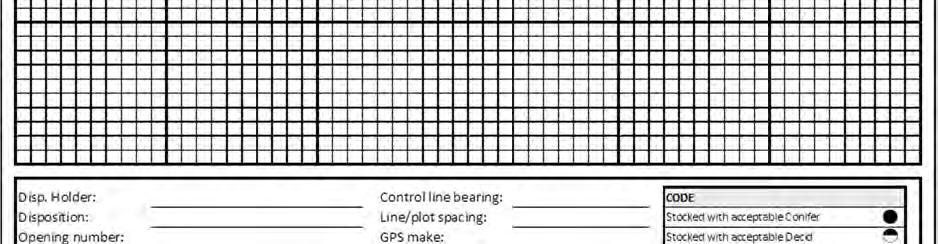
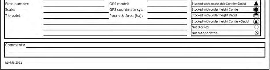
240 Page 240 of 315
241 Opening number: ESTABLISHMENT SURVEY TALLY SHEET A Coniferous tree stocking Deciduous tree stocking Plot status Acceptable trees Above min. Line Plot Species height? Under height trees (to confirm LIG) Above min. Species height? Acceptable trees Above min. Species height? Under height trees (to confirm LIG) Above min. Species height? One of: SR-C, SR-D, SR-CD, UH-C, UH-D, UH-CD, NSR ESTSA 2011 Page of Page 241 of 315
242 Opening number: ESTABLISHMENT SURVEY TALLY SHEET B Coniferous tree stocking Deciduous tree stocking Plot status GPS X coordinate GPS Y coordinate Plot ID Acceptable trees Under height trees (to confirm LIG) Acceptable trees Under height trees (to confirm LIG) Above min. Above min. Above min. Above min. Species height? Species height? Species height? Species height? One of: SR-C, SR-D, SR-CD, UH-C, UH-D, UH-CD, NSR ESTSB 2011 Page of Page 242 of 315
243 Appendix 5. Statistical accuracy for stocking surveys The Establishment (Intensive survey) and Performance (D Standard CSR/NSR) methods have been designed to satisfy the statistical accuracy standards outlined below (Table 11-2). The error levels are inherent in the survey design and do not include unintended surveyor error. Accuracy will be further reduced if surveyor error, either by omission or commission, is introduced into the sampling. The approximate sampling error for stocking of an individual opening can be calculated using the formula: ±200 where, E = sampling error in percent; p = proportion of stocked plots expressed as a decimal (e.g., 70% = 0.70); q = 1-p; proportion of plots poorly stocked as a decimal (e.g., = 0.30); and, n = number of plots established. The following table presents the statistical accuracy of stocking for Establishment and Performance (D Standard CSR/NSR) surveys: Table Statistical accuracy requirements by opening size. Opening area (ha) Variable Statistical Accuracy ± 12.5% with 95% confidence > 4.0 ± 10.0% with 95% confidence when stocking is 80% or greater The approximate sampling error for top height and diameter will be calculated as: where, E = sampling error in percent; and, SE = standard error of the mean E = 2 SE Page 243 of 315
244 Appendix 6. Number of sample plots for stocking surveys The number of sample plots required is based on the allowable error of the stocking estimate (Table 11-3). The total number of plots required to sample any given area can be calculated using the formula: 40,000 p q n = 2 E where, n = number of sample plots to be established p = proportion of plots stocked expressed as a decimal q = 1 - p; proportion of plots poorly stocked expressed as a decimal E = maximum allowable sampling error Table Required number of sample plots by opening size. Opening area (ha) Required Sample Plots ha Minimum of 12.4 plots/ ha ha Minimum of 41 plots/opening ha Minimum of 64 plots/opening ha Minimum of 2.77 plots/ ha Page 244 of 315
245 Appendix 7. Summary of line and plot spacing Table Line and plot spacing, number of plots, and allowable error by opening or NAA area Opening area (ha) Square metres per plot Square spacing (m) Number of plots (plots/ha) Number of plots Allowable error (±%) Page 245 of 315
246 Opening area (ha) Square metres per plot Square spacing (m) Number of plots (plots/ha) Number of plots Allowable error (±%) Page 246 of 315
247 Opening area (ha) Square metres per plot Square spacing (m) Number of plots (plots/ha) Number of plots Allowable error (±%) Page 247 of 315
248 Appendix 8. RSA Stocking Reporting Cover Page Page 248 of 315
249 Page 249 of 315
250 Appendix 9. Forest Areas ARIS requires the submission of a Forest Area code for each opening. The Forest Area codes are historical despite the creation of new Forest Area boundaries on 15 January, Table Forest Area codes. Code NEB1 NEB2 NEB3 NES1 NES2 NES3 NWB1 NWB2 NWB3 NWB5 NWB6 NWB7 NWB8 SES1 SES2 SES3 SES4 Forest Area Waterways Lakeland Athabasca Foothills Yellowhead Woodlands Wapiti River MacKenzie Upper Hay Martin Hills East Peace Lakeshore Smoky River Crowsnest Bow Clearwater Brazeau Page 250 of 315


251 Figure Map of Forest Areas. Page 251 of 315
252 Appendix 10. Acquisition of aerial photography data dictionary Table Data dictionary for dbase attribute file Field name Format Description Note TDH $4.0 ARIS stakeholder code for the timber disposition holder requesting photo acquisition DISPOS $10.0 Disposition refers to the legal document that grants the right to harvest timber. Reforestation liability is attached to the disposition. OPENING $11.0 Unique ARIS number based on legal location of the centroid of the harvested area FIELD_NUM $12.0 The number assigned by the timber disposition holder to the opening that appears on the AOP or harvest plan map. SKID_DATE $10.0 Skid clearance date in YYYY- MM-DD AREA_HA 7.2 Net harvested hectares for the opening E.g., RCTL E.g., FMA , CTQA130010, etc. E.g., A E.g., 12A E.g., Eligible codes: 0.01 to SHAPE_LENG 13.7 Length of polygon in m Eligible codes: to SHAPE_AREA 13.5 Area of polygon in m 2 Eligible codes: to Note: Arc defaults may preclude setting fieldnames and formats as per Table However, to ensure consistency of all shape file submissions please ensure that the fieldname order in Table 11-6 is followed. Page 252 of 315
253 Appendix 11. Sampling Unit and Poorly Regenerated Areas stratification data dictionaries Table Interp1: Data dictionary for interpreted Sampling Unit attribute data (Aerial Stratification System only) Field Name Format Description Note PHOTO_Y 4.0 Year of photography For example: 2008, 2009, 2010, etc. (no blanks allowed) PHOTO_M 2.0 Month of photography Eligible codes: 1 to 12 PHOTO_D 2.0 Day of photography Eligible codes: 1 to 31 EMULSION $3.0 Emulsion of photography TC = True color, CIR = Color infrared; BW = Black and white Eligible codes: TC, CIR, BW (no blanks allowed) SCALE $10.0 Scale of photography For example: "20000", "15000", for conventional photography; 20 for digital photography (no blanks allowed) LEAF $8.0 Indicator of season of photography Eligible codes: "leaf-on", "leafoff" INTRP_Y 4.0 Year of interpretation For example: 2008, 2009, 2010, etc. (no blanks allowed) INTRP_M 2.0 Month of interpretation Eligible codes: 1 to 12 INTRP $20.0 Name of interpreter For example "Elihu Steward", "Reginald Loomis", etc. (no blanks allowed) OPENING $11.0 Opening number consistent with ARIS POLYGON $3.0 Unique Sampling Unit number within an opening UNIQUE_ID $16.0 Unique identifier is made up of opening number and polygon For example: " A", etc. (no blanks allowed) For example: "001", "002", "003" etc. (no blanks allowed) For example: " A_001", " A_002", etc. (no blanks allowed) AREA_HA 7.2 Area (hectares) of polygon Eligible codes: 0.01 to HIGHER_STRAT $5.0 Descriptor for higher-level stratification NAA 2.0 Net Assessment Area indicator For example: SA, UF, LF or Tend1, Tend2. If not applicable, then 0, Eligible codes: 0, 1, or 2 Page 253 of 315
254 Field Name Format Description Note SP1 $2.0 Species code of most dominant species in the regeneration layer SP1_PER 2.0 SP1's contribution to species composition to nearest 10% SP2 $2.0 Species code of second most dominant species in the regeneration layer SP2_PER 2.0 SP2's contribution to species composition to nearest 10% SP3 $2.0 Species code of third most dominant species in the regeneration layer SP3_PER 2.0 SP3's contribution to species composition to nearest 10% SP4 $2.0 Species code of fourth most dominant species in the regeneration layer SP4_PER 2.0 SP4's contribution to species composition to nearest 10% SP5 $2.0 Species code of fifth most dominant species in the regeneration layer SP5_PER 2.0 SP5's contribution to species composition to nearest 10% SP_CL $4.0 Species composition class (derived field based on SP1 through SP5) Eligible codes: blank, Sw, Se, Sb, Pl, Pj, Pw, Pf, Fb, Fa, Fd, La, Lt, Lw, Aw, Pb, Bw, P, A Eligible codes: 0, 2, 3, 4, 5, 6, 7, 8, 9, 10 Eligible codes: blank, Sw, Se, Sb, Pl, Pj, Pw, Pf, Fb, Fa, Fd, La, Lt, Lw, Aw, Pb, Bw, P, A Eligible codes: 0, 1, 2, 3, 4, 5, 6, 7, 8, 9, 10 Eligible codes: blank, Sw, Se, Sb, Pl, Pj, Pw, Pf, Fb, Fa, Fd, La, Lt, Lw, Aw, Pb, Bw, P, A Eligible codes: 0, 1, 2, 3, 4, 5, 6, 7, 8, 9, 10 Eligible codes: blank, Sw, Se, Sb, Pl, Pj, Pw, Pf, Fb, Fa, Fd, La, Lt, Lw, Aw, Pb, Bw, P, A Eligible codes: 0, 1, 2, 3, 4, 5, 6, 7, 8, 9, 10 Eligible codes: blank, Sw, Se, Sb, Pl, Pj, Pw, Pf, Fb, Fa, Fd, La, Lt, Lw, Aw, Pb, Bw, P, A Eligible codes: 0, 1, 2, 3, 4, 5, 6, 7, 8, 9, 10 Eligible codes: blank, Hw, HwPl, HwSx, SwHw, PlHw, SbHw, Sw, Pl, Sb, Fd Page 254 of 315
255 Field Name Format Description Note DENSITY 6.0 Total density (stems per ha) call for the regeneration layer DEN_CL $2.0 Density class (derived field based on DENSITY) AVE_HT 4.1 Average height of the regeneration layer in meters SPATIAL 1.0 Spatial distribution call for the regeneration layer MIXED $1.0 Mixedwood pattern call for the regeneration layer R_SP1 $2.0 Species code of most dominant species in the residual layer R_SP1_PER 2.0 R_SP1's contribution to species composition to nearest 10% R_SP2 $2.0 Species code of second most dominant species in the residual layer R_SP2_PER 2.0 R_SP2's contribution to species composition to nearest 10% R_SP3 $2.0 Species code of third most dominant species in the residual layer R_SP3_PER 2.0 R_SP3's contribution to species composition to nearest 10% R_DEN 6.0 Total density (stems per ha) call for the residual layer R_CC 2.0 Crown closure of the residual layer to the nearest 10% R_AVE_HT 4.1 Average height of the residual layer Eligible codes: 0 to Eligible codes: blank, L, M, H, D Eligible codes: 0 to 99.9 Eligible codes: 0, 1, 2, 3, 4, 5 Eligible codes: blank, I, A, P Eligible codes: blank, Sw, Se, Sb, Pl, Pj, Pw, Pf, Fb, Fa, Fd, La, Lt, Lw, Aw, Pb, Bw, P, A Eligible codes: 0, 4, 5, 6, 7, 8, 9, 10 Eligible codes: blank, Sw, Se, Sb, Pl, Pj, Pw, Pf, Fb, Fa, Fd, La, Lt, Lw, Aw, Pb, Bw, P, A Eligible codes: 0, 1, 2, 3, 4, 5, 6, 7, 8, 9, 10 Eligible codes: blank, Sw, Se, Sb, Pl, Pj, Pw, Pf, Fb, Fa, Fd, La, Lt, Lw, Aw, Pb, Bw, P, A Eligible codes: 0, 1, 2, 3, 4, 5, 6, 7, 8, 9, 10 Eligible codes: 0 to Eligible codes: 0, 2, 3, 4, 5, 6, 7, 8, 9, 10 Eligible codes: 0 to 99.9 Page 255 of 315
256 Field Name Format Description Note R_SPT 1.0 Spatial distribution call for the residual layer Eligible codes: 0, 1, 2, 3, 4, 5 Page 256 of 315
257 Table Interp2: Data dictionary for interpreted Poorly Regenerated Areas attribute data (Aerial Stratification System only) Field Name Format Description Note OPENING $11.0 Opening number consistent with ARIS POLYGON $5.0 Unique poorly regenerated polygon number within an opening UNIQUE_ID $17.0 Unique identifier is made up of opening number and polygon For example: " A", etc. (no blanks allowed) For example: "PR1", "PR2", "PR3" etc. (no blanks allowed) For example: " A_PR1", " A_PR2", etc. (no blanks allowed) AREA_HA 7.2 Area (hectares) of polygon Eligible codes: 0.1 to NAA 2.0 Net Assessment Area indicator PR_SP1 $2.0 Species code of most dominant species in the poorly regenerated area PR_SP1_PER 2.0 SP1's contribution to species composition to nearest 10% PR_SP2 $2.0 Species code of second most dominant species in the poorly regenerated area PR_SP2_PER 2.0 SP2's contribution to species composition to nearest 10% PR_SP3 $2.0 Species code of third most dominant species in the poorly regenerated area PR_SP3_PER 2.0 SP3's contribution to species composition to nearest 10% PR_SP_CL $4.0 Species composition class (derived field based on SP1 through SP3) Eligible codes: 0, 1, or 2 Eligible codes: blank, Sw, Se, Sb, Pl, Pj, Pw, Pf, Fb, Fa, Fd, La, Lt, Lw, Aw, Pb, Bw, P, A Eligible codes: 0, 4, 5, 6, 7, 8, 9, 10 Eligible codes: blank, Sw, Se, Sb, Pl, Pj, Pw, Pf, Fb, Fa, Fd, La, Lt, Lw, Aw, Pb, Bw, P, A Eligible codes: 0, 1, 2, 3, 4, 5, 6, 7, 8, 9, 10 Eligible codes: blank, Sw, Se, Sb, Pl, Pj, Pw, Pf, Fb, Fa, Fd, La, Lt, Lw, Aw, Pb, Bw, P, A Eligible codes: 0, 1, 2, 3, 4, 5, 6, 7, 8, 9, 10 Eligible codes: blank, Hw, HwPl, HwSx, SwHw, PlHw, SbHw, Sw, Pl, Sb, Fd Page 257 of 315
258 PR_DEN 6.0 Total density (stems per ha) call for the poorly regenerated area PR_AVE_HT 4.1 Average height of the poorly regenerated area in meters Eligible codes: 0 to 199 Eligible codes: 0 to 99.9 Page 258 of 315
259 Table Interp3: Data dictionary for optional interpreted Sampling Unit stocking data (Aerial Stratification System only) Field Name Format Description Note PHOTO_Y 4.0 Year of photography For example: 2008, 2009, 2010, etc. (no blanks allowed) PHOTO_M 2.0 Month of photography Eligible codes: 1 to 12 PHOTO_D 2.0 Day of photography Eligible codes: 1 to 31 EMULSION $3.0 Emulsion of photography TC = True color, CIR = Color infrared; BW = Black and white Eligible codes: TC, CIR, BW (no blanks allowed) SCALE $10.0 Scale of photography For example: "20000", "15000", for conventional photography; 20 for digital photography (no blanks allowed) LEAF $8.0 Indicator of season of photography Eligible codes: "leaf-on", "leafoff" INTRP_Y 4.0 Year of interpretation For example: 2008, 2009, 2010, etc. (no blanks allowed) INTRP_M 2.0 Month of interpretation Eligible codes: 1 to 12 INTRP $20.0 Name of interpreter For example "Elihu Steward", "Reginald Loomis", etc. (no blanks allowed) OPENING $11.0 Opening number consistent with ARIS POLYGON $3.0 Unique Sampling Unit number within an opening UNIQUE_ID $16.0 Unique identifier is made up of opening number and polygon For example: " A", etc. (no blanks allowed) For example: "001", "002", "003" etc. (no blanks allowed) For example: " A_001", " A_002", etc. (no blanks allowed) AREA_HA 7.2 Area (hectares) of polygon Eligible codes: 0.01 to HIGHER_STRAT $5.0 Descriptor for higher-level stratification NAA 2.0 Net Assessment Area indicator PS_SG1 $2.0 Species code of most dominant species in the regeneration layer For example: SA, UF, LF or Tend1, Tend2. If not applicable, then 0, Eligible codes: 0, 1, or 2 Eligible codes: AW, PL, SB, SW Page 259 of 315
260 Field Name Format Description Note PS_SG1_PER 2.0 SP1's contribution to species composition to nearest 10% PS_SG2 $2.0 Species code of second most dominant species in the regeneration layer PS_SG2_PER 2.0 SP2's contribution to species composition to nearest 10% PS_SG3 $2.0 Species code of third most dominant species in the regeneration layer PS_SG3_PER 2.0 SP3's contribution to species composition to nearest 10% PS_SG4 $2.0 Species code of fourth most dominant species in the regeneration layer PS_SG4_PER 2.0 SP4's contribution to species composition to nearest 10% PS_SP_CL $4.0 Species composition class (derived field based on PS_SP1 through PS_SP5) PS_CON 3.0 Conifer species group stocking (nearest 1%) call for the regeneration layer PS_TOTAL 3.0 Total stocking (nearest 1%) call for the regeneration layer Eligible codes: 0, 1, 2, 3, 4, 5, 6, 7, 8, 9, 10 Eligible codes: blank, AW, PL, SB, SW Eligible codes: 0, 1, 2, 3, 4, 5, 6, 7, 8, 9, 10 Eligible codes: blank, AW, PL, SB, SW Eligible codes: 0, 1, 2, 3, 4, 5, 6, 7, 8, 9, 10 Eligible codes: blank, AW, PL, SB, SW Eligible codes: 0, 1, 2, 3, 4, 5, 6, 7, 8, 9, 10 Eligible codes: blank, Hw, HwPl, HwSx, SwHw, PlHw, SbHw, Sw, Pl, Sb, Fd Eligible codes: 0 to 100 Eligible codes: 0 to 100 Page 260 of 315
261 Appendix 12. Examples of net downs and hierarchical delineation of Sample Units Step 1: Define the Net Assessment Area (NAA). This step nets out any land use dispositions or natural deletions, as outlined in Section For example, Graphic A shows the original opening boundaries prior to net-down. Graphic B shows the NAA after a well site is netted out. Step 1 Defining Net Assessment Area Well Site A B Step 2: Delineate the Sampling Units within the NAA based on regeneration layer species composition: Where tree species composition class differs (Table 8-4); and, Where the tree species composition percentage of a single species within the cover type differ by more than 10%; and, Where Sampling Unit size (minimum 2 ha) and width (minimum 50 m) criteria are met. For example, Graphic A (below) shows the preliminary line work based on differences in species composition class (as defined in 1 above). Graphic B (below) shows the final line work for species composition. The line between Sw8Aw2 and Sw7Aw3 is not drawn because the criterion 2 (above) is not met. In this case, the differences in the second species composition did not differ by more than 10%. Page 261 of 315
262 Step 2 Species Comp Class Delineation Sw 8 Aw 2 Aw 9 Sw 1 Aw 9 Sw 1 Sw 7 Aw 3 Sw 8 Aw 2 A B Step 3: Delineate the Sampling Units based on regeneration layer density: Where total density class differs (Table 8-5); and Where total density differs by more than the minimums outlined in Table 8-6; and Where Sampling Unit size (minimum 2 ha) and width (minimum 50 m) criteria are met. For example, Graphic A (below) shows the preliminary line work based on total density class differences (as define in 1 above). Graphic B (below) shows the final line work for density class. The line between M-1100 and L-950 is excluded because it did not meet the second density delineation criterion (i.e., densities did not differ by more than 200 stems per hectare). Step 3 Density Class Delineation M-1600 L-900 H-2100 M-1600 L-900 H-2100 M-1100 L-950 M-1050 A B The Final Stratified Opening graphic (below) shows the correct stratification for the opening. For each Sampling Unit, all attributes are interpreted and recorded. Page 262 of 315
263 Final Stratified Opening Aw 8 Sw 2 H-2100 Sw 8 Aw 2 L-900 Sw 8 Aw 2 M-1600 Aw 9 Sw 1 M-1050 Well Site Page 263 of 315

264 Appendix 13. Process to determine mixedwood pattern The following graphics illustrate a two-step process interpreters may use when making the mixedwood pattern call. The graphic represents a 4 ha Sampling Unit composed of a mixture of coniferous and deciduous stems. Coniferous trees are represented by green dots while deciduous trees are represented by orange dots. While there are trees throughout the Sampling Unit, the relative distribution of coniferous trees versus deciduous trees is variable. Page 264 of 315


265 Step 1: Consider the spatial distribution of coniferous trees. Interpreters should visually scan the Sampling Unit and focus in on the areas with a high concentration of primarily coniferous trees (areas outlined with red dots). Although coniferous trees are present outside of the highlighted areas, the focus is on where significant (i.e. greater than 200 stems per hectare) concentrations of coniferous trees exist. Page 265 of 315


266 Step 2: Determine the general proportion of the area where coniferous trees occur in the presence of significant deciduous trees. The following graphic identifies the areas where significant (i.e. greater than 200 stems per hectare) deciduous occurs. The majority of the area occupied by conifer stems occurs in patches in the absence of significant deciduous stems. Thus, in this example, the aggregate mixedwood pattern code would be assigned to this Sampling Unit. Note that this example is intended to be a simplified supporting rationale for how a mixedwood pattern call is made. In general, an interpreter should simply scan the Sampling Unit with this process in mind and be able to assign a mixedwood pattern code based on the estimated level of conifer and deciduous intermixing. Page 266 of 315
267 Appendix 14. Master Opening List data dictionary Table Opening1: Data dictionary for Master Opening List (Aerial Stratification and Non-photo Systems). Field name Format Description Note SYSTEM_TYPE $1.0 Type of performance assessment DISPOSITION_HOL DER $28.0 Timber Disposition Holder: the legal name of the forest company or organization that retains the reforestation liability for the opening DISPOSITION $10.0 Disposition: refers to the legal document that grants the right to harvest timber. Reforestation liability is attached to the disposition. FOREST_AREA $4.0 The Alberta administrative unit (region/area) where the opening is located. FIELD_NUMBER $12.0 The number assigned by the Timber Disposition Holder to the opening that appears on the AOP or harvest plan map. OPENING $11.0 Opening number consistent with ARIS NET_HARVEST_HE CTARES Eligible codes: A or N E.g., River City Timber Ltd. E.g., FMA , CTQA130010, DTAA090001, etc. Eligible codes: NEB1, NEB2, NEB3, NES1, NES2, NES3, NWB1, NWB2, NWB3, NWB5, NWB6, NWB7, NWB8, SES1, SES2, SES3, SES4 E.g., 1234 E.g., " A" (no blanks allowed) 7.2 Area (hectares) from ARIS Eligible codes: 0.01 to UPDATE_AREA 7.2 Updated Area (hectares) from ARIS Eligible codes: blank or 0.01 to SKID_YEAR 4.0 Year of Skid Clearance Eligible codes: 1994 to 2058 SKID_MONTH 2.0 Month of Skid Clearance Eligible codes: 1 to 12 SKID_DAY 2.0 Day of Skid Clearance Eligible codes: 1 to 31 Page 267 of 315
268 PR_AREA 7.2 Poorly regenerated area (hectares) Where the system type is Non-photo this must be provided by the user. Where the system type is Aerial it can be left blank. Eligible codes: blank or 0.00 to Page 268 of 315
269 Appendix 15. Mechanics of the field sample selection computer program Repealed 1 May, Page 269 of 315


270 Appendix 16. Performance sheets Please refer to the data dictionaries in Appendix 14 and 17 for format requirements and descriptions of fields. Page 270 of 315
Forest Management Branch Directive
 SUSTAINABLE RESOURCE DEVELOPMENT Forest Management Branch Directive Directive No. 2005-1 Date April 7, 2006 Subject Regeneration Stratum Declarations and Allowable Cut Adjustments Purpose To provide procedures
Hinton Wood Products A division of West Fraser Mills Forest Management Agreement FMA O.C. 565/2007
 Hinton Wood Products A division of West Fraser Mills Forest Management Agreement FMA 8825 O.C. 565/7 Mountain Pine Beetle Forest Management Plan Amendment Technical Report #2 - Yield Projections - April
AAFMP Reforestation Webinar March 26, Reforestation. Created by: Lee Martens, MSc RPF (#885) Presented by: Andy Shandro RPF (#561)
 Presented by: Andy Shandro RPF (#561)") AAFMP Reforestation Webinar March 26, 2018 1 Reforestation Created by: Lee Martens, MSc RPF (#885) Presented by: Andy Shandro RPF (#561) Overview 2 Reforestation obligation (TMR) 1 Reforestation standard
AAFMP Reforestation Webinar March 26, 2018 1 Reforestation Created by: Lee Martens, MSc RPF (#885) Presented by: Andy Shandro RPF (#561) Overview 2 Reforestation obligation (TMR) 1 Reforestation standard
Polygon Update Protocol Field Manual
 The Forestry Corp. Polygon Update Protocol Field Manual Manning Diversified Forest Management Agreement Area Prepared for: Manning Diversified Forest Products Ltd. Table of Contents 1. BACKGROUND...1 1.1
Appendix II. Growth & Yield Monitoring Plan
 Sundance Forest Industries Ltd. Appendices (Revised) Appendix II. Growth & Yield Monitoring Plan Introduction The Growth & Yield Monitoring Plan has been developed in support of Objectives 22 and 25 of
Appendix II. Growth & Yield Monitoring Plan
 Sundance Forest Industries Ltd. Appendices (Revised) Appendix II. Growth & Yield Monitoring Plan Introduction The Growth & Yield Monitoring Plan has been developed in support of Objectives 22 and 25 of
Annual Status of Reforestation in Alberta Report 2016
 2016 November 6,2017 Agriculture and Forestry 2015-2016 Table of Contents What is this report about? 3 What is reforestation? 4 Why reforest? 5 What does the law require? 5 How is the status of reforestation
Spatial Digital Data Submission Standards Directives. Frequently Asked Questions (v6.0)
") 1 General Spatial Digital Data Submission Standards Directives Frequently Asked Questions (v6.0) Q1. What is the intent of the Spatial Data Directives? A1. The Spatial Data Directives will specify that
1 General Spatial Digital Data Submission Standards Directives Frequently Asked Questions (v6.0) Q1. What is the intent of the Spatial Data Directives? A1. The Spatial Data Directives will specify that
Reforestation Strategies
 Reforestation Strategies Reforestation Program: Silviculture treatments, monitoring (surveys) & reporting, road reclamation, research & trials. Are FMA holders responsible for reforestation? Yes. Under
2017/18 Reforestation Plan
 8235 2017/18 Reforestation Plan for Development Corp LP, F-26. Abstract A report prepared and submitted annually by Tolko Industries, and Norbord for Development Corp LP., to summarize plans and implementation
Resource Analysis Group Olympic Resource Management Suite 300, 475 W. Georgia St. Vancouver, B.C. Canada V6B 4M9
 OPERATIONAL PLANNING AND ANALYSIS Resource Analysis Group Suite 300, 475 W. Georgia St. Vancouver, B.C. Canada V6B 4M9 MODEL II - OBJECTIVE-DRIVEN PERFORMANCE STANDARDS PHASE 1 - STRATEGY DEVELOPMENT Prepared
Chapter 3 TIMBER SUPPLY ANALYSIS
 Introductions Chapter 3 TIMBER SUPPLY ANALYSIS 3.1 Introduction The ANC mill facility requires about 265,000 Bone Dry Tonnes (approximately 690,000 m 3 ) of virgin coniferous wood fibre and 17,000 tonnes
TIMBER SUPPLY ANALYSIS
 TIMBER SUPPLY ANALYSIS W14 FMU FMA 752 Blue Ridge Lumber Inc. Woodlands Department P.O. Box 179 Whitecourt, Alberta T7S 1P9 (78) 648-62 SEPTEMBER 1 st, 25 Table of Contents Foreword...1 1. Net Landbase
Values, Objectives, Indicators and Targets
 Values, Objectives, Indicators and Targets 2007 2017 Forest Management Plan for FMA 0200041 May 31, 2007 Prepared by: The Forestry Corp. May 31, 2007 Values, Objectives, Indicators and Targets 2007 2017
Fort St. John Pilot Project. December 20, Page 1 of 14
 Fort St. John Pilot Project Management Strategy December 20, 2005 Page 1 of 14 TABLE OF CONTENTS I. STRATEGY OBJECTIVES 3 II. BACKGROUND 3 III. CLASSIFYING AND TRACKING FOREST TYPES 6 A. Initial Cutblock
E8 Forest Management Plan
 E8 Forest Management Plan Alberta Sustainable Resource Development in cooperation with Foothills Forest Products Forestry Division Foothills Forest Area Hinton, Alberta 1 2 TABLE OF CONTENTS 1.0 Introduction...11
6.0 Silviculture 205
 6.0 Silviculture 205 6.0 Silviculture Foothills Forest Products (FFP) is committed to an effective silviculture strategy in order to achieve sustainable forest management objectives in E8. Lodgepole pine
Executive Summary. Approval Decision Conditions. Approval Condition. Requirement Approval Authority Date
 Executive Summary The Tolko Industries Ltd. (Tolko), Vanderwell Contractors (1971) Ltd. (VCL), and Alberta Plywood Ltd. (APL) Forest Management Plan (FMP) dated September 1, 2009 is approved subject to
2 Cruise Design. April 15, 2015 Amendment No
 Timber Pricing Branch Quality Assurance 2 Cruise Design April 15, 2015 Amendment No. 3 2-1 Cruising Manual Ministry of Forests, Lands and NRO 2.1 Cruise Objective The objective of the timber cruise is
7 th Floor Street Edmonton, Alberta Canada T5K 2M4
 Public Lands and Forests Division Forest Management Branch 7 th Floor 9920-108 Street Edmonton, Alberta Canada T5K 2M4 Telephone (780) 427-8474 Fax (780) 427-0085 March 9, 2006 Ref: 06292-010 Mr. Murray
FMU C5 FOREST MANAGEMENT PLAN
 FMU C5 FOREST MANAGEMENT PLAN Development of the Preferred Forest Management Scenario Prepared By: The Forestry Corp. May 26, 2006 EXECUTIVE SUMMARY A timber supply analysis (TSA) for the C5 Forest Management
C5 FOREST MANAGEMENT PLAN APPENDIX 8B. GROWTH AND YIELD MONITORING PROGRAM
 C5 FOREST MANAGEMENT PLAN 2006 2026 APPENDIX 8B. GROWTH AND YIELD MONITORING PROGRAM C5 Forest Management Plan 2006 2026 2 Appendix 8B. Growth and Yield Monitoring Program FMU C5 FOREST MANAGEMENT PLAN
Draft Report. Innovative Silviculture Surveys in the Fort St John Code Pilot Project. March 31, 2004
 Draft Report Innovative Silviculture Surveys in the Fort St John Code Pilot Project March 31, 2004 1 Introduction The Fort St. John (FSJ) TSA is a Forest Practices Code Pilot Project Area. In the fall
Forest Management Planning Standard Interpretive Bulletin: Stewardship Reporting Requirements
 Executive Summary The Stewardship Reporting Requirements provides stewardship report content and expectations for all Alberta timber disposition holders. Successful forest management plan stewardship reporting
Reforestation. After working through this lesson, you should be able to:
 Reforestation The summaries and their associated interpretations contained in this document are for general information only, not legal advice. To interpret or apply the law, you must consult the legally
Appendix I: Phase 3 Inventory Landbase Determination Process
 Appendix I: Phase 3 Inventory Landbase Determination Process Table of Contents Appendix I 1 PHASE 3 INVENTORY LANDBASE DETERMINATION PROCESS...1 1.1 Forest That Prohibits Timber Harvest... 1 1.2 Inoperable
4. Forest Landscape Pattern and Structure
 4. Forest Landscape Pattern and Structure This section of the Comprehensive Description of the DFA provides a present-day snapshot of the DFA in terms of the species composition, age class, seral stage
Silviculture Survey Procedures Manual
 RESOURCE PRACTICES BRANCH Silviculture Survey Procedures Manual -Regen Delay, Stocking and Free Growing Surveys - plus Alternative Survey Methodologies April 1, 2015 1 This version of the Silviculture
Sustainable Forest Management
 Sustainable Forest Management 2014 Facts & Statistics Spring 2016 ISBN 978-1-4601-2805-3 ISSN 2368-4941 Agriculture and Forestry R e f o r e s t i n g H a r v e s t e d A r e a s Forests are a renewable
6 Stump Cruising. April 1,
 Timber Pricing Branch Stump Cruising 6 Stump Cruising April 1, 2017 6-1 Cruising Manual Ministry of Forests, Lands and NRO 6.1 Introduction The methods described in this chapter are prioritised by safety
Supplemental Verification Methodology
 Supplemental Verification Methodology To: ALL FOREST PROJECT VERIFIERS Date: July 03, 2012 Re: Updated Guidance for Verification of sampled pools for Forest Projects Version 3.3 of the Forest Project Protocol
Detailed Forest Management Plan Approval Decision Blue Ridge Lumber Inc. A Subsidiary of West Fraser Mills Ltd. Whitecourt, Alberta
 Detailed Forest Management Plan Approval Decision Blue Ridge Lumber Inc. A Subsidiary of West Fraser Mills Ltd. Whitecourt, Alberta Forest Management Agreement #7500020 Detailed Forest Management Plan
Sample design for the 2002 pilot of Riverside s new approach to silviculture obligations
 Sample design for the 2002 pilot of Riverside s new approach to silviculture obligations To successfully pilot Riverside s proposed approach to regulating silviculture obligations on the TFL 49 Results-based
Lillooet Forest District. Inventory Plan
 Lillooet Forest District Inventory Plan MINISTRY OF FORESTS RESOURCES INVENTORY BRANCH JUNE 1998 Table of Contents 1. INTRODUCTION...1 1.1 Background...1 1.2 Objectives...2 2. BUSINESS CONSIDERATIONS...3
11.0 FOREST INVENTORY DATA
 11.0 FOREST INVENTORY DATA Initially GPRC used Phase III inventory information supplied by Public Lands and Forest Division while a new inventory was conducted to Alberta Vegetation Inventory standards.
The Forest Resources Management (Saskatchewan Environmental Code Adoption) Regulations
 Regulations") FOREST RESOURCES MANAGEMENT 1 CODE ADOPTION) F-19.1 REG 11 The Forest Resources Management (Saskatchewan Environmental Code Adoption) Regulations being Chapter F-19.1 Reg 11 (effective January 5, 2015).
FOREST RESOURCES MANAGEMENT 1 CODE ADOPTION) F-19.1 REG 11 The Forest Resources Management (Saskatchewan Environmental Code Adoption) Regulations being Chapter F-19.1 Reg 11 (effective January 5, 2015).
Proposed AAC An AAC (15/10 standard) has been calculated based on Alberta Vegetation Inventory data. The proposed AAC is: Incidental deciduous
 has been calculated based on Alberta Vegetation Inventory data. The proposed AAC is: Incidental deciduous") 12.0 TIMBER SUPPLY ANALYSIS All deciduous and conifer volume estimates and harvest schedules presented in this FMP have been developed using existing provincial resource inventory data. Underlying the
12.0 TIMBER SUPPLY ANALYSIS All deciduous and conifer volume estimates and harvest schedules presented in this FMP have been developed using existing provincial resource inventory data. Underlying the
Detailed Forest Management Plan Approval Decision. Slave Lake Pulp Corporation A Division of West Fraser Timber Slave Lake, Alberta
 Detailed Forest Management Plan Approval Decision Slave Lake Pulp Corporation A Division of West Fraser Timber Slave Lake, Alberta Forest Management Agreement #9000028 Date: April 3, 2003 Effective: May
Last Updated Spring 2015 Resource Practices Branch Ministry of Forests, Lands& Natural Resource Operations
 The Silviculture Survey Accreditation Process Last Updated Spring 2015 Resource Practices Branch Ministry of Forests, Lands& Natural Resource Operations For more information on silviculture surveys; http://www.for.gov.bc.ca/hfp/silviculture/silviculture_surveys.html
TIMBER MARKER AND CRUISER TASK BOOK Required under authority of Part 5 of Act 451 of P. A. 1994, as amended.
 Michigan Department of Natural Resources Forest Resources Division Required under authority of Part 5 of Act 451 of P. A. 1994, as amended. The material contained in this book accurately defines the performance
Ground Rules Addendum Mountain Pine Beetle Operations
 Ground Rules Addendum Mountain Pine Beetle Operations As referenced in both the Mountain Pine Beetle Action Plan for Alberta and Interpretive Bulletin for Planning Mountain Pine Beetle Response Operations,
Interpretive Bulletin. Planning Mountain Pine Beetle Response Operations
 Planning Mountain Pine Beetle Response Operations 1.0 Preamble This applies to the working forest land category on Alberta Public land (see MPB Action Plan for Alberta, section 3.1). Mountain pine beetle
Sustainable Forest Management Plan. Appendix 6: Reforestation Strategy Stocking Standards and Crop Tree Requirements
 Appendix 6: Reforestation Strategy Stocking Standards and Crop Tree Requirements Appendix 6- Reforestation Strategy Stocking Standards and Crop Tree Requirements 1.1 Introduction The Landscape Level Reforestation
SUPPLEMENTAL TIMBER SUPPLY ANALYSIS PROCEDURES & RESULTS
 SUPPLEMENTAL TIMBER SUPPLY ANALYSIS PROCEDURES & RESULTS SILVACOM REFERENCE #: F-57 PREPARED BY: Silvacom Ltd. 3825-93 Street Edmonton, Alberta T6E 5K5 SEPTEMBER 1, 21 REF: F-57 TABLE OF CONTENTS FORWARD...
Field Measurement Approach
 A Guide to the Field Measurement Approach for Forestry in the Emissions Trading Scheme August 2018 Ministry for Primary Industries Downloadable copies of this publication are available at: www.mpi.govt.nz.
Yield Curve Documentation
 Millar Western Forest Products Ltd. Yield Curve Documentation 2007-2016 Detailed Forest Management Plan February 28, 2007 1 2007-2016 DFMP Yield Curve Documentation EXECUTIVE SUMMARY Millar Western Forest
Foresters utilize a variety of specialized tools to accomplish the following tasks:
 Forestry Tools Foresters utilize a variety of specialized tools to accomplish the following tasks: Measure trees Conduct forest inventory Mark trees Measure logs Plant trees Navigation and orientation
Block Planning and Plot Layout 4
 Block Planning and Plot Layout 4 A good survey plan is essential to an efficient waste survey. April 1, 2007 Amendment No. 7 4-1 Prov. Log. Residue & Waste Measure. Proced. Manual Ministry of Forests and
P Forest Management Plan
 Boucher Bros. Lumber Ltd. P14 2009-2018 Forest Management Plan Chapter 3: Performance Standards (VOITs) December 23, 2009 Table of Contents 1. INTRODUCTION... 1 2. PERFORMANCE STANDARDS SUMMARY... 3 3.
C5 FOREST MANAGEMENT PLAN APPENDIX 9A. SILVICULTURE
 C5 FOREST MANAGEMENT PLAN 2006 2026 APPENDIX 9A. SILVICULTURE C5 Forest Management Plan 2006 2026 2 PLANNING LEVEL SILVICULTURE PRESCRIPTION C5 FOREST MANAGEMENT UNIT As described in the Alberta Forest
Matanuska-Susitna Borough Timber Inventory 2006
 Matanuska-Susitna Borough Timber Inventory 2006 1989 MSB Forest Management Plan 17 Forest Management Units (FMU) 138,000 acres classified forest land Approximately 84,700 acres Commercial Timber Land
Uncompahgre Mesas Project Area 2015 Monitoring Report
 Uncompahgre Mesas Project Area 15 Monitoring Report This report presents a summary of data from the Uncompahgre Mesas project area. Pre-harvest data were collected on 18 ½ acre plots beginning in 9 ( Original
Chapter 5 Forecasting and the Preferred Forest Management Scenario
 Millar Western Forest Products Ltd. Chapter 5 Forecasting and the Preferred Forest Management Scenario 2007-2016 Detailed Forest Management Plan November 15, 2007 1 SUMMARY A requirement of the Detailed
forests ISSN
 Forests 2013, 4, 1-27; doi:10.3390/f4010001 Article OPEN ACCESS forests ISSN 1999-4907 www.mdpi.com/journal/forests The Validation of the Mixedwood Growth Model (MGM) for Use in Forest Management Decision
Tolko Industries Ltd. Athabasca OSB Woodlands 2016 SFI Surveillance Audit
 Tolko Industries Ltd. Athabasca OSB Woodlands 2016 SFI Surveillance Audit From January 19-22, 2016, an audit team from KPMG Performance Registrar Inc. (KPMG PRI) carried out an SFI surveillance audit of
Purpose. Policy Context. Procedures
 Title: Directive - Sites Number: Agriculture and Forestry, Forestry Policy, 2016, No. 1 Program Name: Forest Management Branch Timber Production, Auditing & Revenue Effective Date: This document was updated
APPENDIX 3 LAND BASE CLASSIFICATION
 APPENDIX 3 LAND BASE CLASSIFICATION Mountain Pine Beetle Action Plan Land Base Update March 17, 2009 Mountain Pine Beetle Action Plan Land Base Update Table of Contents 1 Introduction... 1 2 Background...
Partial Harvest (Non-clearcut) Planning and Monitoring Guidelines
 Planning and Monitoring Guidelines") Partial Harvest (Non-clearcut) Planning and Monitoring Guidelines A Supplement to the Alberta Forest Management Planning Standard Forest Management Branch Forestry Division Sustainable Resource Development
Partial Harvest (Non-clearcut) Planning and Monitoring Guidelines A Supplement to the Alberta Forest Management Planning Standard Forest Management Branch Forestry Division Sustainable Resource Development
Overview of WSFG. Scott McPherson April 4, 2006 North Bay
 Overview of WSFG Scott McPherson April 4, 2006 North Bay A Bit of History Methodology developed in 1994 In response to a new business relationship between Government and the forest industry In response
LAND BASED INVESTMENT STRATEGY. Current Reforestation Assessment Maintenance of Existing Investments in the Forests for Tomorrow Program
 LAND BASED INVESTMENT STRATEGY Current Reforestation Assessment Maintenance of Existing Investments in the Forests for Tomorrow Program SUMMARY Introduction The Ministry of Forests, Lands and Natural Resource
Detailed Forest Management Plan Chapter 7 - Growth and Yield
 Detailed Forest Management Plan 2001 2026 Chapter 7 - Growth and Yield December 15, 2006 Spray Lake Sawmills December 15, 2006 Chapter 7- Growth and Yield Report Estimating forest growth and yield is fundamental
Silvicultural Effectiveness Monitoring Manual for Ontario
 Silvicultural Effectiveness Monitoring Manual for Ontario TECHNICAL SERIES 2001, Queen s Printer for Ontario Printed in Ontario, Canada Single copies of this publication are available at no charge from
Stand Level Ecological Guidelines
 Stand Level Ecological Guidelines Drayton Valley Woodlands February 16, 1999 Updated February 8, 2005 2 Table of Contents Overview.............................................................. 2 Components
TIMBER SALE PRESCRIPTION
 Michigan Department of Natural Resources - Forest, Mineral and Fire Management TIMBER SALE PRESCRIPTION Date 08/01/2011 Timber Sale Number (if applicable) 61-0??-11-01 Name Scott Throop Email Address throops@michigan.gov
Equipment. Methods. 6. Pre-treatment monitoring will take place during the growing season.
 Vegetation and Fuel Monitoring Protocols for the Long Island Pine Barrens Fire Management Demonstration Site Project Adapted from the UMass Project Managing Fuels in Northeastern Barrens Plot Selection,
Appendix A: Vegetation Treatment Descriptions and Unit Specific Design Criteria
 Appendix A: Vegetation Treatment Descriptions and Unit Specific Design Criteria The table below describes the Kabetogama Project proposed vegetation treatments associated with Alternative 2. The treatment
ANC Timber Ltd 2016 Re-certification Audit
 ANC Timber Ltd 2016 Re-certification Audit From October 18-21, 2016, an audit team from KPMG Performance Registrar Inc. (KPMG PRI) carried out an SFI re-certification audit of ANC Timber Ltd s (ANC s)
Variable Method Source
 Appendix S1 Appendix S1: Table S1 Plot variables Variable Method Source COVERS % shrub cover ocular estimate of shrub cover % forb cover ocular estimate of forbs % coarse woody debris % live overhead canopy
Harvesting of Young Stands in BC
 Harvesting of Young Stands in BC SPECIAL INVESTIGATION MAY 2018 FPB/SIR/48 TABLE OF CONTENTS GLOSSARY OF TERMS i EXECUTIVE SUMMARY 1 INTRODUCTION 3 BACKGROUND 4 How are minimum harvest criteria determined?...
Silviculture Surveys in Manitoba: Co-op Work Term Report Gordon MacDonald Peter Herbert ENVR 3920/ /12/2012
 Silviculture Surveys in Manitoba: Co-op Work Term Report Gordon MacDonald Peter Herbert ENVR 3920/3910 14/12/2012 Table of Contents ACKNOWLEDGMENTS INTRODUCTION 1.0: Background 2.0: 2012 Field Season 3.0:
SECTION SEVEN IMPLEMENTATION OF THE PLAN
 SECTION SEVEN IMPLEMENTATION OF THE PLAN 7 Implementation of the DFMP This DFMP is the hierarchy document that provides guidance and direction for the development of Annual Operating Plans (harvesting
Dome Road Timber Harvest Plan within
 Dome Road Timber Harvest Plan within Tr'ondek Hwech'in Traditional Territory FOREST MANAGEMENT BRANCH ENERGY MINES AND RESOURCES YUKON GOVERNMENT Prepared: August2010 Approved by Acting Director Forest
Vegetation Resources Inventory Localization Procedures
 Vegetation Resources Inventory Localization Procedures Prepared by Resource Information Branch Ministry of Sustainable Resource Management For the Resources Information Standards Committee March 2005 Version
Visual Management System and Timber Management Application 1
 Visual Management System and Timber Management Application 1 2 Warren R. Bacon and Asa D. (Bud) Twombly / Abstract: This paper includes an illustration of a planning process to guide vegetation management
Sunshine Coast Timber Supply Area
 Sunshine Coast Timber Supply Area Vegetation Resources Inventory Photo Interpretation Project Implementation Plan PREPARED BY: GERRY SOMMERS & WARREN NIMCHUK ISSUED: AUGUST 2005 REVISED: MARCH 2006 1.
FFT Ministry Survey Standard March 4, 2009
 Ministry of Forests and Range FFT Ministry Survey Standard March 4, 2009 These standards apply, in addition to the General Standards for Ministry Funded Programs (FS 1001), to all survey activities funded
Temagami Management Unit Independent Forest Audit 2011 (April 1, 2006 March 31, 2011) Action Plan Status Report
 Action Plan Status Report") Temagami Management Unit Independent Forest Audit 2011 (April 1, 2006 March 31, 2011) Action Plan Status Report Prepared by: Don Farintosh, R.P.F. Temagami Management Forester MNR North Bay District Original
Temagami Management Unit Independent Forest Audit 2011 (April 1, 2006 March 31, 2011) Action Plan Status Report Prepared by: Don Farintosh, R.P.F. Temagami Management Forester MNR North Bay District Original
Sustainable Forest Management
 Sustainable Forest Management 2015 Facts & Statistics Spring 2017 ISBN 978-1-4601-3520-4 ISSN 2368-4844 Agriculture and Forestry Annual Allowable Cut Sustainable forest management requires long-term planning.
Sundance Forest Industries Ltd. Forest Management Plan 2007
 Sundance Forest Industries Ltd. Forest Management Plan 27 Timber Supply Analysis Documentation April 27, 27 EXECUTIVE SUMMARY Sundance Forest Industries Ltd. entered into a forest management agreement
Appendix A: Vegetation Treatments
 Appendix A: Vegetation Treatments In general, the proposed actions for the Light Restoration project focuses on establishing the composition, structure, pattern, and ecological processes necessary to make
Vegetation Resources Inventory
 Vegetation Resources Inventory Ground Sampling Quality Assurance Procedures Prepared by Ministry of Forests Resources Inventory Branch for the Terrestrial Ecosystem Task Force Resources Inventory Committee
Forestry Consulting Services ITB - 17/ AO. Submitted Questions and Answers. February 14, 2018
 Forestry Consulting Services ITB - 17/18-011 AO Submitted Questions and Answers February 14, 2018 1. Can we access recent (last two years) contracts for similar forestry work contracted by the SRWMD? In
Simulating Regeneration Dynamics in Upland Oak Stands
 Simulating Regeneration Dynamics in Upland Oak Stands Powered By Powered by: USDA Forest Service Southern Research Station Dr. David Loftis Powered By Powered by: Regen for Excel is a simulation model
Contents Predicting Light Availability In Broadleaf Stands A Tool For Mixedwood Management
 i ii Contents Predicting Light Availability In Broadleaf Stands A Tool For Mixedwood Management... 1 Light a limiting resource... 1 Regression models can be used to predict light availability... 1 Light
Vegetation Resources Inventory
 Vegetation Resources Inventory Guidelines for Preparing a Project Implementation Plan for Ground Sampling Prepared by Ministry of Sustainable Resource Management Resource Information Branch For the Terrestrial
The Art of Timber Cruising Part II Fixed-Area Plots
 The Art of Timber Cruising Part II Fixed-Area Plots In this second article on timber cruising, we will be looking at a simple method of preparing a basic description of the forest compartments in your
Whiskey Jack Forest. Independent Forest Audit April 1, 2004 to March 31, Management Unit Action Plan Status Report
 Whiskey Jack Forest Independent Forest Audit April 1, 2004 to March 31, 2009 Management Unit Action Plan Status Report Independent Forest Audit Action Plan Status Report Whiskey Jack Forest Independent
2.0 Plant /Tree Processes in the Boreal Forest
 2.0 Plant /Tree Processes in the Boreal Forest 2.1 Processes common to most boreal plants a) All plants, animals, or anything living must have respiration which is the changing of energy from one form
Attempt any FOUR questions. All questions are of equal marks.
 Attempt any FOUR questions. All questions are of equal marks. Regular 2069 Magh/Falgun 1. (a) A forester standing 30m away from the base of a 5 inward leaned Oak tree on regular slope observed with Abney
TIMBER SALE PRESCRIPTION
 Michigan Department of Natural Resources - Forest, Mineral and Fire Management GENERAL Date TIMBER SALE PRESCRIPTION 01/17/11 Timber Sale Number (if applicable) 720041201 LOCAL CONTACT Name Tom Barnes
Growth Intercept Method for Silviculture Surveys
 Growth Intercept Method for Silviculture Surveys AUGUST 1995 Canada CANADA-BRITISH COLUMBIA PARTNERSHIP AGREEMENT ON FOREST RESOURCE DEVELOPMENT: FRDA II BC Growth Intercept Method for Silviculture Surveys
Timber Supply Analysis
 Timber Supply Analysis 27 217 Forest Management Plan for FMA 241 May 31, 27 Prepared by: The Forestry Corp. May 31, 27 Timber Supply Analysis 27 217 FMP FOR FMA 241 Forest Landscape Metrics forms one
Hinton Wood Products A division of West Fraser Mills Forest Management Agreement FMA O.C. 565/2007
 Hinton Wood Products A division of West Fraser Mills Forest Management Agreement FMA 8800025 O.C. 565/2007 Mountain Pine Beetle Forest Management Plan Technical Report #3 - Annual Allowable Cut Projection-
ANNUAL PUBLIC REPORT. Reporting Period May April
 ANNUAL PUBLIC REPORT Reporting Period May 01 2001 April 30 2002 2001/2002 Annual Report for Alberta Region The purpose of this report is to inform the public of Canfor s activities within Alberta for
The TSL is situated west of the community of Meadow Lake, and is held solely by MLOSB.
 Tolko Meadow Lake OSB Limited Partnership 2016 SFI Re-certification Audit From October 12th to 14th, 2016, an audit team from KPMG Performance Registrar Inc. (KPMG PRI) carried out an SFI recertification
Forest Management Plan Update
 Forest Management Plan Update We have been working What is a Forest Management Plan? The details of where, when and how trees on Crown land in Alberta are harvested and managed for sustainability are contained
Nova Scotia Forest Inventory
 Nova Scotia Forest Inventory Based on Forest Inventory Permanent Sample Plots Measured between 1994 and 1998 Report FOR 2000-1 TABLE OF CONTENTS 1.0 INTRODUCTION 1 1.1 Background 1 2.0 METHODS 2 3.0 RESULTS
REGENERATION AND SAPLING SURVEY
 REGENERATION AND SAPLING SURVEY AIM To measure regeneration of seedlings and saplings, using a protocol developed by the Canadian Forest Service, Sault Ste. Marie. RATIONALE Monitoring seedlings and saplings