Is there deforestation by slash-and-burn agriculture in South Cameroon?
|
|
|
- Moris Evans
- 6 years ago
- Views:
Transcription
1
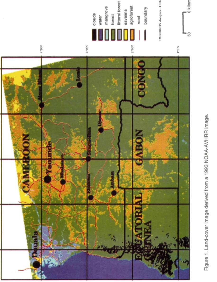
2 Is there deforestation by slash-and-burn agriculture in South Cameroon? Jacques Imbernon South Cameroon from Yaounde to Equatorial Guinea is a forest area where slash-and-burn agriculture is practised. The area is characterized by a north-south vegetation gradient. Population density and land-use intensity are both high. Vegetation is mostly semideciduous forest, but the north of the region is characterized by Imperata cylindrica savanna, and the south by the dense Congolese rain forest. Population densities, according to the 1995 census, vary greatly from 65.9 inhabitants per square kilometre in the Monatele arrondissement north of Yaounde to only 3.8 in the Ambam arrondissement south of Yaounde near Equatorial Guinea. Fallow length is still high in the south (around 20 years) but is decreasing to less than 3 years in the north. This gradient was the main reason for selecting the area as an Alternatives to Slash-and-Burn 1 benchmark site (Manga 1994). Deforestation within the benchmark area takes different forms and has different impacts, with a number of different slash-and-burn practices. Here we look at how these practices are influencing the landscape, as observed by satellite sensors. And therefore we look both at the process involved from a historical perspective and at the actual landscape pattern. Historical perspective At the beginning of the 20th century, South Cameroon was mainly forest. However, humans were already putting it under threat. On Moisel's map (1913) savanna stretched from the north to Yaounde, to the orient side of the Lekie River and to the left bank of the Sanaga River. Between savanna and primary forest there was the 'Parklanschaft', a degraded forest. Thus those landscapes, which resembled Letouzey's vegetation maps (1968), had already been humanized. At this time, immigration came mainly from the north, as part of the vast movement of population from savanna (north) to forest (south), which started 2 centuries ago. Cultivation was based on slash-and-burn practices. Within the forest, settlers avoided the rivers, both because they were unhealthy and because the swamps and their many tributaries were an obstacle to movement. However, where easy fords were found, there were settlements. Thus the traditional settlements and their areas of cultivation were not distributed along rivers but were spread throughout the landscape. The French colonial administration in 1916, following German colonization, changed this landscape pattern by opening roads and encouraging small-scale farmers to cultivate cocoa along them. In this way the colonial administration could increase exports, collect income taxes more easily and settle the farmers who were practising shifting cultivation. However, when we examine population changes from 1916 to the present, instability and heterogeneity appear to be characteristic: population increased in some arrondissements and decreased in others. More surprising is the fact that over the past decades, the demographic balance in the less inhabited areas mostly forested has been negative, while in the most inhabited areas around Yaounde, it has been positive (ORSTOM 1995). 1 Alternative to Slash-and-Burn (ASB) is a systemwide programme of the Consultative Croup for International Agricultural Research; it is convened by the International Centre for Research in Agroforestry (ICRAF).
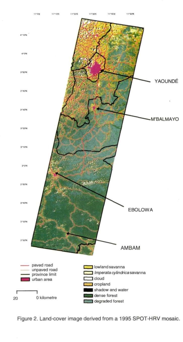
3 Thus the landscape of the forest area of South Cameroon has been mainly shaped by the opening and asphalting of roads. These roads have offered access to markets, particularly for cocoa production. But demographic figures show that they have not attracted as many new immigrants looking for land as would have been expected. In this study we try to better characterize the landscape and its changes over time using low-resolution and high-resolution remote sensing data. We look particularly at slash-andburn practices and try to identify if they are leading to deforestation in South Cameroon. The actual landscape: towns, street villages, corridors, agroforestry... and shifting cultivation Whether in a low-resolution NOAA-AVHRR image (fig. 1) or a high-resolution SPOT-HRV image (fig. 2), towns and roads appear to be the main features around which deforestation has occurred. Around the capital, Yaounde, land use is intensive, and its influence can be noticed many kilometres away. This is the main feature in the landscape, because of the major effect of its own market (1.2 million people). Figure 3 shows the impact of towns in the different departments. We can easily notice the large impact of Yaounde (Mfoundi Department), near where most of the land is cultivated. The other towns M'Balmayo (Nyong et So), Ebolowa and Ambam (Ntem) are small and have very little influence on the surrounding landscape. But they also consist of features around which land use is more intensive 2. The towns in Lekie and Mefou regions in the north show that land-use intensity is higher between 4 and 12 km from towns (fig. 3). There the farmers have to go farther afield to get better soils than do the farmers working near settlements. In the southern regions (Nyong et So and Ntem), towns have no impact on land-use intensity, and over 40% of the total cropland is located more than 20 km from a town. Land use is also intensive along the tarmac road that joins Obala, Yaounde, M'Balmayo and Ebolowa, and even farther along the untarmacked road to Ambam and the border. Most of the settlements, 'street villages', are located along these roads. The houses are 1st surrounded by homegardens, dominated by banana. Behind them are the cocoa plantations, mostly more than 40 years old and under dense and regular tree cover. This cultivation can be considered agroforestry. Farther are old fallow lands where the forest is regenerating, and then young fallow. Finally we reach the food-crop fields and the new fields in the forest, called 'esep'. Food-crop fields are small, less than 1 hectare, with many mixed crops cassava, sweet banana, groundnut, cocoyam, maize, vegetables. The cultivated land along the road networks creates corridors in the spatial distribution of land uses, from roads to forest. These corridors are less than 5 km wide on either side, and within these corridors land-use intensity decreases exponentially from the roadside. There are few differences in land-use intensities between administrative provinces (fig. 4). Only Ntem region is different, with lower land-use intensity near the roads and more farther from them. This difference may be due to a higher fragmentation of croplands within the forest, but it is also the result of lower density in the road network. On average over the whole area, 63% of the total cropland is less than 1 km from a road. However, the landscape is still dominated by forest. About 65% of the total area is forested, comprising 30% degraded forest and 35% dense forest, mainly in the south (Imbernon 1996). Cropland repiesents only 25% of the total area, but overall there are many differences in land use intensity between regions 56% in Lekie region and 14% in Ntem. Thus slash-and-burn agriculture takes different forms from area to area, even if as a whole it can be considered as part of a shifting cultivation system. 2 Land use intensity is considered here as the proportion of cropland area in relation to total cropland. 2
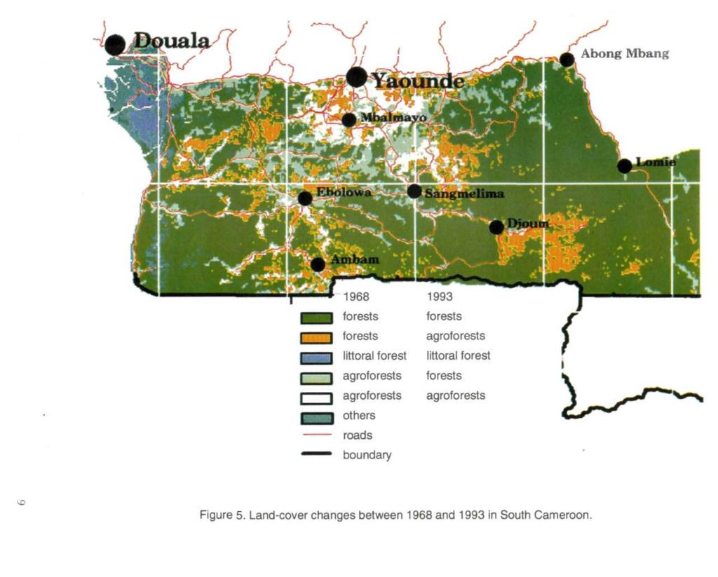
4 The main difference between north and south is the length of fallow, according to the availability of land. Manga (1994) cites 7.5 years for the Ebolowa region, 5.4 years ior M'Balmayo and 3.9 years for Yaounde. In Lekie Department (north of Yaounde), fallow is mainly herbaceous. The lack of available land has become a serious threat for the shifting cultivation system, and it is leading to degraded soils. This is also the only department where the food supply grown does not cover the needs only 87% are covered because of high population densities (66 inhabitants per square kilometre in 1995) and transfers to the market in Yaounde. In Mefou and Nyong et So departments (in the centre of the area), fallow length is higher. After burning a fallow 5 to 7 years old, the main crops during the 1st 2 years are cassava and groundnuts. After the forest is slashed and burned (in this area the forest is secondary), 'ngon' (Cucumeropsis manii) and plantain are preferred during the 1st year ('essep' field). In these departments, food-crop production is based on shifting cultivation. But when farmers want to extend their cropland, they have to cultivate far from roads, and access becomes a major constraint. In Ntem, in the south of the area, fallow is often more than 20 years old and can be considered like a secondary forest. The primary forest is still very extended and the 'essep' field is frequent. Thus in this area there is room for shifting cultivation, and it is a sustainable system. Monitoring deforestation by remote sensing We used the spatial data available, which unfortunately were heterogeneous: a 1 : vegetation map (Letouzey 1968, 1985), a set of NOAA-AVHRR cloudless images (1991 to 1994) and a set of 4 SPOT images (1995). Out of the set of 11 NOAA- AVHRR images, only 1 (January 1993) was cloud free enough for us to process a landcover classification 3. The land-cover map obtained from this AVHRR image (1-km resolution) was then compared (fig. 5) with Letouzey's map based on 1968 data. Land-cover changes compared at this scale (table 1) are nearly balanced. Table 1. Land covers compared between Letouzey's 1968 map and a 1993 AVHRR image Letouzey map Agroforest 4 Forest Forest Agroforest AVHRR 1993 agroforest forest agroforest forest Area (km 2 ) A large proportion of forest was undisturbed during this period 62.84% of the total area. Part of the agroforest became forest 13.88% and part of the forest was converted in agroforest 12.12%. Thus it appears that 1.76% of the total area was again covered by forest. However, these results have to be considered with extreme care, and they do not consider the deforestation process. They do indicate shifting cultivation practices and agroforest returning to forest (secondary forest) as forest is being converted to agroforest. The classified mosaic of the 4 SPOT images in 1995 (fig. 2) has a much better resolution (20 m) and gives us more accurate information about fragmentation of cropland and 3 We processed an unsupervised classification and then merged clusters by photointerpreting this classified image, using 45 ground control points picked out in 1994 with a GPS (global positioning system). 4 Agroforest here is a land-cover unit that we have defined as a non-continuous tree canopy cover. 3
5 forest. It was not possible to classify cocoa plantations using these SPOT data because their radiometric signature was too close to the signature of the degraded forest. Therefore, comparing land-cover statistics on the area covered by the SPOT mosaic with the AVHRR classified image shows huge differences (table 2). Table 2. Comparison of land cover between 1993 (AVHRR) and 1995 (SPOT) Forest Agroforest Cropland Other (roads, clouds...) AVHRR 1993 (ha) SPOT 1995 (ha) Within this comparison, the main difference comes from the classification of the agroforest unit. With NOAA-AVHRR resolution (1 km), agroforest is a mosaic of forest and non-forest that includes cocoa plantations. With SPOT-HRV resolution (20 m), land cultivated in food crops and young fallow within the forest are better identified, but cocoa plantations under tree shadow are seldom recognized and as a result are often classified as forest. As the extent of cocoa plantations is nearly the same as that of land in food crops, the huge difference between remotely sensed results can be explained: SPOT-HRV underestimates cropland because it does not identify cocoa plantations NOAA-AVHRR overestimates cropland because it averages fragmented patches of forest and non-forest Thus in this study, the remote sensing data that we used did not allow an accurate evaluation of the extent of cultivated land. Until new sensors with better geometric and radiometric resolution are available, we recommend extreme care when using satellite images on this landscape, which includes cocoa plantations under tree shadow. But even if this is a strong limitation, deforestation by slash-and-burn agriculture occurs mainly for food crops. There are very few new cocoa plantations because farmers go back to cultivate the old ones. Thus deforestation can be identified by a high-resolution sensor like SPOT-HRV, and deforestation monitoring is therefore possible. Unfortunately our heterogeneous data set (AVHRR and HRV) does not allow us to do this monitoring in this situation. Is the South Cameroon forest a frontier? As we were not able to monitor deforestation with the available satellite data, we examined demographic changes. These data are not directly linked to deforestation (Imbernon 1997) because many other factors, such as integration with markets, urbanization and land speculation, could relate to the change in land use. But population change can be a good indicator if, at household scale, driving forces do not change landuse intensity. Farming systems in the South Cameroon forest are identical to those at the beginning of the 1970s (Weber 1974, Leplaideur 1985). They are based on cocoa plantations and on shifting cultivation for food crops, as described above. During the period from 1976 to 1987, stagnant cocoa prices with rising prices for the goods consumed by farmers led to a decline of agricultural terms of trade (Jim Gockowski, IITA-Cameroon, personal communication). One consequence was that farmers did not plant any more cocoa and that parts of 4
6 replace cocoa benefits and give access to goods, the food cropland extent remains the same. Another consequence of the decline, in agricultural terms, was the movement to urban centres, mainly to Douala and Yaounde. For rural people, and for young people as well, towns are a symbol of progress. But also, the bureaucracy in these urban areas during this period created a demand for jobs. So population has been always moving, as part of the ancient flux from savanna to forest, or as part of the shifting cultivation system, or more recently as part of the urbanization process. These have never been mass movements. When we look at table 3, high heterogeneity between departments appears to be a characteristic. And we notice that population is decreasing in the forested area (-0.29% growth rate in Ntem Department, -3% in Nyong et So), but on the other hand, population is increasing in the Yaounde area (+7.34% growth rate in Mfoundi Department). Table 3. Population density and growth rate in the area, between 1976 and 1987 Rural population density Rural population (hab/km 2 ) growth (%) Mfoundi Lekie Mefou Nyong et So Ntem Source: Jim Gockowski, IITA-Cameroon Thus, the South Cameroon forest does not seem to be a frontier. In the study area, from Yaounde to Ambam, there is no significant colonization of uninhabited forest areas by migrants, and indeed no significant dynamic of the landscape at the forest margin, except around Yaounde. As long as the Cameroon government does not implement policies promoting the colonization of this forest area, by opening roads and offering new incentives, deforestation through slash-and-burn agriculture will remain very low. References Imbernon J Visions of landscapes and vegetation changes. Nairobi: ICRAF. Imbernon J Population growth and deforestation: the case of Rondonia in the Brazilian Amazon. Nairobi: ICRAF. Leplaideur A Les systemes agricoles en zone forestiere : les paysans du Centre et du Sud Cameroun. Paris: CIRAD-IRAT. 615 p. Letouzey R Etude phytogeographique du Cameroun. Paris: P. Lechevalier. Letouzey R Notice de la carte phytogeographique du Cameroun au 1/ Institut de la carte Internationale de la vegetation, Fasc. 3-4: Manga T Alternatives to Slash-and-Burn project: Cameroon benchmark site annual report. Yaounde: IRA. Moisel M Karte von Kamerun. Berlin: D. Reimer. [ORSTOM] Institut francaise de recherche scientifique pour le developpement en cooperation Atlas regional du Sud-Cameroun. Paris: ORSTOM. Weber J Structures agraires et evolution des milieux ruraux. Le cas de la region cacaoyere de Centre-Sud Cameroun. Cahier ORSTOM, Sciences Humaines 14(2):
7
8
9
10
CHANGES IN LAND COVER IN FRENCH GUYANA BETWEEN 1990 AND 2012
 D E L I N V E N TA I R E FORESTIER JULY 2015 = 35 CHANGES IN LAND COVER IN FRENCH GUYANA BETWEEN 1990 AND 2012 The Kyoto Protocol signatory countries are committed, depending on each individual case, to
Title How fast is the Amazon rainforest. disappearing?
 Title How fast is the Amazon rainforest disappearing? 40% increase between 2001 and 2002! Title How fast is the Amazon rainforest disappearing Q1. What is deforestation? 40% increase between 2001 and 2002!
Amazon Deforestation
 Title Amazon Deforestation 40% increase between 2001 and 2002! Recent advert by Paddy Power. Read more on this story here Title Amazon Deforestation What is deforestation? 40% increase between 2001 and
Alternatives to Slash-and-Burn
 Alternatives to Slash-and-Burn Summary Report and Synthesis of Phase II in Cameroon J. Kotto-Same, A. Moukam, R. Njomgang, T. Tiki-Manga, J. Tonye, IRAD, C. Diaw, CIFOR, J. Gockowski, S. Hauser, S. Weise,
STATUS, NEEDS AND PRIORITIES FOR SUSTAINABLE SOIL MANAGEMENT IN SIERRA LEONE
 STATUS, NEEDS AND PRIORITIES FOR SUSTAINABLE SOIL MANAGEMENT IN SIERRA LEONE Presentation at the Launch of Global Soil Partnership in Accra, Ghana (4-6 February, 2013) By Susan A. Robert Soil Scientist
Sustainable Improvement of Swiddens for Livelihoods and Environmental Services (SISLES) Report
 Report") Sustainable Improvement of Swiddens for Livelihoods and Environmental Services (SISLES) Report Call For Report Call for final report Africa-Brazil Projects funded in the 2011/12 Report Status Submitted
Sustainable Improvement of Swiddens for Livelihoods and Environmental Services (SISLES) Report Call For Report Call for final report Africa-Brazil Projects funded in the 2011/12 Report Status Submitted
Socio-ecological production landscapes, Agroforestry and the Satoyama Initiative
 Socio-ecological production landscapes, Agroforestry and the Satoyama Initiative Dennis Garrity, Director General Roberto Porro, Latin America Regional Coordinator World Agroforestry Centre (ICRAF) World
Name of project: Climate Adaptation for Biodiversity, Ecosystem Services and Livelihoods in Rural Madagascar
 Name of project: Climate Adaptation for Biodiversity, Ecosystem Services and Livelihoods in Rural Madagascar Overall objectives: Assist Madagascar to improve its understanding and assessment of the impacts
2013_AP46_Scholtz.pdf. Coresta Sustainable Tobacco Production In Africa Anton Scholtz. AP Document not peer-reviewed by CORESTA
 Coresta 2013 Sustainable Tobacco Production In Africa Anton Scholtz Tobacco Production in Africa COUNTRY FARMERS HECTARES VOLUME ( 000) MALAWI 750 000 180 000 230 000 ZIMBABWE 65 000 84 000 128 000 TANZANIA
Agroforest benefits: linking biodiversity conservation with economic development for rural communities
 Agroforest benefits: linking biodiversity conservation with economic development for rural communities Achieving a balance between equitable development and the preservation of biological resources in
FOREST COVER MAPPING AND GROWING STOCK ESTIMATION OF INDIA S FORESTS
 FOREST COVER MAPPING AND GROWING STOCK ESTIMATION OF INDIA S FORESTS GOFC-GOLD Workshop On Reducing Emissions from Deforestations 17-19 April 2007 in Santa Cruz, Bolivia Devendra PANDEY Forest Survey of
Unit 3. The primary sector
 Unit 3. The primary sector - Economic activities devoted to obtaining resources directly from nature. Agrarian space - Agrarian space: land where agrarian activities are undertaken - Rural space: non urban
Intercropping with Rubber for Risk Management
 Intercropping with Rubber for Risk Management Rubber is expected to become the Lao PDR's number one export. Chinese and Vietnamese investors are involved in a number of projects after consultation with
CIFOR Presentation: Oil and Forests
 CIFOR Presentation: Oil and Forests Center for International Forestry Research Does Oil Wealth Help Conserve Forests? Macroeconomic impacts on tropical forests and their utilisation Sven Wunder, Economist,
Chapter 10. Latin America Today
 Chapter 10 Latin America Today Chapter Objectives Discuss aspects of the Latin American economy and how geography affects transportation and communications. Explain how Latin America s forest resources
Village level analyses of poverty and land use/cover in West Aceh Sonya Dewi, Andree Ekadinata, Danan Prasetyo Hadi
 Village level analyses of poverty and land use/cover in West Aceh Sonya Dewi, Andree Ekadinata, Danan Prasetyo Hadi I. Background How people use land is always an integral question to ask in order to understand
Degradation of of Forest Ecosystems
 Degradation of Forest Ecosystems NREM 612 Dr. Bruland I. Definitions: >250, forester, geographer, legal, etc. A. What constitutes a forest? 1. Sometimes clear boundaries bet. forest & non-forest, otherwise
ADOPTION POTENTIAL OF ROTATIONAL HEDGEROW INTERCROPPING IN THE HUMID LOWLANDS OF CAMEROON Ann Degrande and Bahiru Duguma
 Network Paper No.103 Agricultural Research & Extension Network July 2000 ADOPTION POTENTIAL OF ROTATIONAL HEDGEROW INTERCROPPING IN THE HUMID LOWLANDS OF CAMEROON Ann Degrande and Bahiru Duguma Abstract
8.1 Agricultural Landscapes and Production Methods.
 AP Human Geography Kuby: Agricultural Landscapes NAME: HOUR: Agricultural Landscapes and Production Methods DIRECTIONS: Click on the website listed below. Under Computerized Chapter Activities please select
INTERNATIONAL JOURNAL OF GEOMATICS AND GEOSCIENCES Volume 3, No 2, 2012
 INTERNATIONAL JOURNAL OF GEOMATICS AND GEOSCIENCES Volume 3, No 2, 2012 Copyright by the authors - Licensee IPA- Under Creative Commons license 3.0 Research article ISSN 0976 4380 Landuse / Landcover change
INTRODUCTION FORESTS & GREENHOUSE GASES
 INTRODUCTION FORESTS & GREENHOUSE GASES Until recently, much of the debate and concern surrounding the loss of tropical forests has focused on the loss of biodiversity, and to a lesser extent, the loss
1.2 If we cannot define it, we cannot save it
 1.2 If we cannot define it, we cannot save it Meine van Noordwijk and Peter Akon Minang Introduction In the discussions on reducing emissions from forests and other aspects of land use, the negotiators
Exploiting linkages between soil quality, biodiversity and agricultural production
 Exploiting linkages between soil quality, biodiversity and agricultural production Andrew Gillison Center for Biodiversity Management Queensland, Australia Theme 1.1 Limitations to African Agriculture
BCI Criterion 4.2. Smallholders. Conversion Risk Assessment Procedure. Version 0.1
 BCI Criterion 4.2 Conversion Risk Assessment Procedure Smallholders Version 0.1 Identification Name of producer: Name of Production Unit: Location (administrative unit, province/state and country): Area
Forest Monitoring in Tropical Regions
 Forest Monitoring in Tropical Regions Manuela Hirschmugl & Mathias Schardt Institute of Digital Image Processing, Joanneum Research Content: 1. Background 2. Data 3. Methods 3.1. Pre-processing 3.2. Segmentation
Forest & Trees Strengthening policy & practice to meet the needs of forest & tree dependent people, & sustain a healthy environment for all
 Forest & Trees Strengthening policy & practice to meet the needs of forest & tree dependent people, & sustain a healthy environment for all Andrew Taber, Robert Nasi, Tony Simons, Laura Snook, Meine &
By Gerald Urquhart, Walter Chomentowski, David Skole, and Chris Barber
 By Gerald Urquhart, Walter Chomentowski, David Skole, and Chris Barber The clearing of tropical forests across the Earth has been occurring on a large scale basis for many centuries. This process, known
Understanding tropical deforestation
 Understanding tropical deforestation By NASA on 03.13.17 Word Count 2,411 Two logging trucks on the Kalabakan-Sapulot-Road take heavy tropical timber logs to the log pond in Kalabakan, Indonesia. NASA
Forest and Land Cover Monitoring by Remote Sensing Data Analysis
 Low Carbon Asia Research Network (LoCARNet) 3rd Annual Meeting Bogor, Indonesia November 24 26, 2014 Forest and Land Cover Monitoring by Remote Sensing Data Analysis Muhammad Ardiansyah Center for Climate
SECTOR ASSESSMENT (SUMMARY): AGRICULTURE, NATURAL RESOURCES, AND RURAL DEVELOPMENT 1
: AGRICULTURE, NATURAL RESOURCES, AND RURAL DEVELOPMENT 1") Country Partnership Strategy: Timor-Leste, 2016 2020 SECTOR ASSESSMENT (SUMMARY): AGRICULTURE, NATURAL RESOURCES, AND RURAL DEVELOPMENT 1 A. Sector Performance, Problems, and Opportunities 1. Agriculture
Country Partnership Strategy: Timor-Leste, 2016 2020 SECTOR ASSESSMENT (SUMMARY): AGRICULTURE, NATURAL RESOURCES, AND RURAL DEVELOPMENT 1 A. Sector Performance, Problems, and Opportunities 1. Agriculture
Innovation Lab for Food Security Policy
 Innovation Lab for Food Security Policy Nigeria Agricultural Policy Project State Policy Note 8 June 2017 Promoting Cassava Productivity in Benue State: Linking Data and Policy Simon A. Ityo and Abayol
CHAPTER SEVEN ENVIRONMENTAL IMPACTS OF OIL PALM PLANTATIONS
 CHAPTER SEVEN ENVIRONMENTAL IMPACTS OF OIL PALM PLANTATIONS The development of oil palm plantations in Jambi Province has been associated with adverse impacts on the environment. Local NGOs have been the
Between fallow land and land use competition - Land use changes and conflicts in rural and sub urban areas -
 Between fallow land and land use competition - Land use changes and conflicts in rural and sub urban areas - Prof. Dr.-Ing. Theo Kötter Institute of Geodesy and Geoinformation Department of Urban Planning
CONTRACT FARMING IN VIETNAM
 CONTRACT FARMING IN VIETNAM Nguyen Ha Hue National Institute of Agricultural Planning and Projection, Ministry of Agriculture and Development, Vietnam CONTENTS 1. BACKGROUND 2. OVERVIEW OF CONTRACT FARMING
Impact of Land Use and Land Cover Changes on Ecosystem Services in Southwest China
 Impact of Land Use and Land Cover Changes on Ecosystem Services in Southwest China Presented by HU Huabin OUTLINE Introduction Methods Results Discussion Ecosystem services refer to the conditions and
African Cities and The Structural Transformation: Evidence from Ghana and Ivory Coast
 African Cities and The Structural Transformation: Evidence from Ghana and Ivory Coast Remi Jedwab Paris School of Economics & LSE ABCDE 2011 Conference, 01 June 2011. 1 / 33 Research Question Introduction
A look past and a look forward. David Skole Michigan State University
 A look past and a look forward David Skole Michigan State University Antecedents ca. 1988-94 There were important antecedents to the NASA LCLUC program Two important drivers: Large scale Landsat databases
15 Conservation of an Island Biodiversity Hotspot Th e g o v e r n m e n t o f Kapikua wants to expand biodiversity conservation efforts
 15 Conservation of an Island Biodiversity Hotspot Th e g o v e r n m e n t o f Kapikua wants to expand biodiversity conservation efforts on the island. The government has two goals: 1) to protect the overall
PRESENTATION ON METHODS AND APPLICATIONS OF THE AGRICULTURE EXTENSION IN CAMEROON
 PRESENTATION ON METHODS AND APPLICATIONS OF THE AGRICULTURE EXTENSION IN CAMEROON IZMIR 22-05-2013 Presented by Mr Mahama DOUGDJE, head of agricultural extension in the Ministry of Agricultural and Rural
Tree establishment and growth in agroforests (Laxman Joshi)
") Tree establishment and growth in agroforests (Laxman Joshi) The SEXI-FS Spatially explicit individual-tree-based agroforest simulator applied to rubber agroforests (Degi Harja) Forest tree regeneration
Tree establishment and growth in agroforests (Laxman Joshi) The SEXI-FS Spatially explicit individual-tree-based agroforest simulator applied to rubber agroforests (Degi Harja) Forest tree regeneration
AIMS pilot project. Monitoring the rehabilitation of degraded landscapes from Food Assistance for Assets programmes with satellite imagery
 Fighting Hunger Worldwide AIMS pilot project Monitoring the rehabilitation of degraded landscapes from Food Assistance for Assets programmes with satellite imagery September 2017 BEFORE road construction
Smallholder Timber Production: Example of Teak in Luangprabang
 Smallholder Timber Production: Example of Teak in Luangprabang Mountainous topography, undeveloped infrastructure, limited market demand and relative poverty slows farmers' adoption of new technologies.
International Workshop REDD after Copenhagen The Way Forward Hue City, Vietnam 8-10 March, 2010 IISD, ASB-ICRAF, Government of Norway, MARD Vietnam
 International Workshop REDD after Copenhagen The Way Forward Hue City, Vietnam 8-10 March, 2010 IISD, ASB-ICRAF, Government of Norway, MARD Vietnam Econ. Jorge Torres Technical Unit Head SFM BAM SAC Peru
Key Issue 1: Where Did Agriculture Originate?
 Revised 2018 NAME: PERIOD: Rubenstein: The Cultural Landscape (12 th edition) Chapter Nine Food and Agriculture (pages 306 thru 347) This is the primary means by which you will be taking notes this year
Agroforestry: a productivity and resilience booster
 Agroforestry: a productivity and resilience booster Who are we? One of the 15 CGIAR research centres employing about 500 scientists and other staff. We generate knowledge about the diverse roles that trees
MONITORING LAND USE AND LAND USE CHANGES IN FRENCH GUIANA BY OPTICAL REMOTE SENSING
 MONITORING LAND USE AND LAND USE CHANGES IN FRENCH GUIANA BY OPTICAL REMOTE SENSING Photo : Valéry Gond Photo : Valéry Gond Photo Photo : Gaëlle : : Valéry VERGER Gond Gaëlle VERGER ONF, French National
Tropical Agro-Ecosystems
 ropical Agro-Ecosystems to Dry ropical Vegetation Acid soils Alkaline soils From ain Forests to Deserts 3000+ - 1000 mm 12-10 months 2000-500 mm 9-4 months 500-0 mm 4-0 months to Dry ropical Vegetation
Role and importance of Satellite data in the implementation of the COMIFAC Convergence Plan
 Plenary Meeting of the Congo Basin Forest Partnership (CBFP) Palais des Congrès, Yaoundé. Cameroon 11-12 November, 2009 Role and importance of Satellite data in the implementation of the COMIFAC Convergence
Branding Guidelines 2017
 Branding Guidelines 2017 Contents 1 Introduction 2 RTB Program Description 2.1 The program name 2.2 Referring to RTB 2.3 Referring to partners 2.4 Boilerplate 3 RTB Logo 3.1 Program logo 3.2 Reverse logo
Deforestation, shifting cultivation, and tree crops in Indonesia: nationwide patterns of smallholder agriculture at the forest frontier
 , shifting cultivation, and tree crops in Indonesia: nationwide patterns of smallholder agriculture at the forest frontier Draft 1.0 24 May 1996 Comments welcome Kenneth M. Chomitz Charles Griffiths Environment,
Activity 5: The forest territory of Abitibi-Témiscamingue
 Activity 5: The forest territory of Abitibi-Témiscamingue Robin Dubois passe l été en Abitibi! Mike Forrest is spending the summer in Abitibi! Mike has just finished his first semester of CEGEP. He s happy
Land Tenure and Property Rights Issues in Natural Resource Management and Biodiversity Conservation
 Land Tenure and Property Rights Issues in Natural Resource Management and Biodiversity Conservation Presenter: Mark Freudenberger Best Practices for Land Tenure and Natural Resource Governance in Africa
LAND USE PATTERNS FOR CACAO AGROFORESTRY IN SOUTHERN CAMEROON
 African Study Monographs, 32 (4): 135-155, October 2011 135 LAND USE PATTERNS FOR CACAO AGROFORESTRY IN SOUTHERN CAMEROON Kenta SAKANASHI Graduate School of Agriculture, Kyoto University ABSTRACT Deforestation
Monitoring Natural Sal Forest Cover in Modhupur, Bangladesh using Temporal Landsat Imagery during
 Monitoring Natural Sal Forest Cover in Modhupur, Bangladesh using Temporal Landsat Imagery during 1972 2015 Hasan Muhammad Abdullah *, M. Golam Mahboob, Md.Mezanur Rahman, Tofayel Ahmed * Assistant Professor,
Management of common forests in agrarian reform settlements in Northwest Mato Grosso, Brazil
 Management of common forests in agrarian reform settlements in Northwest Mato Grosso, Brazil Peter H. May, Pedro Nogueira, Rob Davenport & Paulo Nunes Federal Rural University of Rio de Janeiro Summary
A new emerging rural world. An overview of rural change in Africa, Atlas for the Nepad Rural Futures programme,
 A new emerging rural world. An overview of rural change in Africa, Atlas for the Nepad Rural Futures programme, Bruno Losch, Geraud Magrin, Jacques Imbernon To cite this version: Bruno Losch, Geraud Magrin,
Deforestation. Becky Herman, Marion High School
 Instructional Sequence/Procedure (Req.): 1. Have students read the handout on deforestation upon entering the classroom. Give them enough time to read it. (Handout: http://www.pachamama.org/effects-of-deforestation)
6. Land take by intensive agriculture
 6. Land take by intensive agriculture Key message Intensive agriculture attributes mainly to South of Europe, particularly to Mediterranean region. Outside this region land areas taken by intensive agriculture
Deliverable 11: Assessment of Alternative Landscape Scenarios
 Deliverable 11: Assessment of Alternative Landscape Scenarios We employed a spatially-explicit, policy-sensitive landscape simulation model to project land-use/landcover trends 30 years into the future.
Building effective multi-disciplinary teams to study complexities of land use change is feasible, but involves high transaction costs.
 ASB-Indonesia PHASE II REPORT Overview & Summary in UNDP-MANDATED FORMAT I. DEVELOPMENT PROBLEM & IMMEDIATE PROBLEMS ATTACKED Conversion of tropical forests reduces biodiversity and releases stored carbon.
Global Agricultural Monitoring in the CGIAR
 Global Agricultural Monitoring in the CGIAR CGIAR-CSI Consortium for Spatial Information Enrica Porcari Chief Information Officer - CGIAR Rome, Italy GEOSS Agric. Monitoring Workshop FAO, Rome 16-18 July,
Uncontrolled Urban Expansion of Amman City and the Disintegration of the Rainfed Lands
 Architecture Research 2017, 7(1): 24-28 DOI: 10.5923/j.arch.20170701.03 Uncontrolled Urban Expansion of Amman City and the Disintegration of the Rainfed Lands Numan Abu Hammad Department of Civil Engineering,
7.2 Rationale for the research component
 7. RESEARCH COMPONENT 7.1 Introduction While the number of commercial modern farms in Africa has increased significantly, most agricultural production (particularly food crop production) is still done
REDD-COMIFAC Meeting March 2008, Paris. REDD Pilot Project COMIFAC: Cameroon. T. Haeusler, S. Gomez
 REDD-COMIFAC Meeting 10-12 March 2008, Paris R e d u c i n g E m i s s i o n s f r o m D e f o r e s t a t i o n a n d D e g r a d a t i o n REDD Pilot Project COMIFAC: Cameroon T. Haeusler, S. Gomez Consortium
1. Irrigated Vegetable Farming in Urban Ghana: A Farming System between Challenges and Resilience
 1. Irrigated Vegetable Farming in Urban Ghana: A Farming System between Challenges and Resilience Pay Drechsel, Andrew Adam-Bradford and Liqa Raschid-Sally This chapter serves as an introduction to the
FEDIOL position on how to address deforestation
 Brussels, July 2016 FEDIOL position on how to address deforestation 1. Background and issue from a crushers and refiners perspective In the fight against climate change, it is of major importance to restrict
Intensification and Agroforestry. What solution for cacao systems?
 Intensification and Agroforestry What solution for cacao systems? Intensification for cocoa systems today Intensification or how to produce more and faster on the same piece of land A - To increase the
Indigenous Perception of Climate Change, its Impacts and Coping Strategies for Sustainable Livelihoods in Guyana and Suriname. Paulette Bynoe, Ph.D.
 Indigenous Perception of Climate Change, its Impacts and Coping Strategies for Sustainable Livelihoods in Guyana and Suriname by Paulette Bynoe, Ph.D. African-Caribbean-Pacific Forestry Research Network
Tragedy of the commons Population Ecology and
 Tragedy of the commons Population Ecology and Tragedy of the Commons v The over-use of common-property or free access resources v Includes clean air and atmosphere, water, land, ocean, wildlife v v Thinking.The
INDONESIA S GREEN AGRICULTURE STRATEGIES AND POLICIES: CLOSING THE GAP
 INDONESIA S GREEN AGRICULTURE STRATEGIES AND POLICIES: CLOSING THE GAP BETWEEN ASPIRATIONS AND APPLICATION Beria Leimona and co-authors: Sacha Amaruzaman, Bustanul Arifin, Fitria Yasmin Bambang Dradjat,
Ghana ER-Program for the Cocoa Forest Mosaic Landscape
 1961 1963 1965 1967 1969 1971 1973 1975 1977 1979 1981 1983 1985 1987 1989 1991 1993 1995 1997 1999 2001 2003 2005 2007 2009 2011 Ghana ER-Program for the Cocoa Forest Mosaic Landscape Over the past century,
3.3 Rural Settlement Patterns. Your Subtitle Goes Here
 3.3 Rural Settlement Patterns Your Subtitle Goes Here Learning Goals Compare three major settlement patterns in Canada Find out about modern rural Canada Settlement Patterns First nations of North America
Enclosed farmland: Arable and Horticultural, Improved and Neutral Grasslands
 executive summary Executive summary 1 Countryside Survey 2000 (CS2000) and the Northern Ireland Countryside Survey 2000 (NICS2000) have been designed to provide detailed information about the habitats
POLICY BRIEF THE NEXT STEP TOWARDS CLIMATE CHANGE MITIGATION: IMPROVING PRODUCTIVITY OF BRAZIL S AGRICULTURAL LANDS
 POLICY BRIEF THE NEXT STEP TOWARDS CLIMATE CHANGE MITIGATION: IMPROVING PRODUCTIVITY OF BRAZIL S AGRICULTURAL LANDS HISTORY REVEALS THAT MODERNIZATION OF AGRICULTURE IS COMPATIBLE WITH PROTECTION OF FORESTS
THE PATHWAYS TO CROP DIVERSIFICATION IN MALAWI; a case study of tobacco production in Malawi
 THE PATHWAYS TO CROP DIVERSIFICATION IN MALAWI; a case study of tobacco production in Malawi INTRODUCTION Crop diversification has been one of the strategies which Malawi has been trying to achieve for
LANDSCAPE APPROACH MANAGEMENT. De-coupling Environmental Degradation from Sustainable Growth
 LANDSCAPE APPROACH MANAGEMENT De-coupling Environmental Degradation from Sustainable Growth 1 APP SUSTAINABILITY ROADMAP The Sustainability Roadmap Vision 2020, launched in 2012, is our strategy to place
FORESTS, DEVELOPMENT, AND CLIMATE ACHIEVING A TRIPLE WIN
 FORESTS, DEVELOPMENT, AND CLIMATE ACHIEVING A TRIPLE WIN THE FOREST INVESTMENT PROGRAM (FIP), a funding window of the CIF, provides indispensable direct investments to benefit forests, development and
Figure 1: map of Lot 9 and HCV 4.2 areas
 The consequences of inappropriate management of slopes especially in Lot 8 could potentially lead to degradation of water quality by the accumulation of sediments in rivers, direct blocking of river flows
Pu Wang Department of Natural Resources Cornell University
 Pu Wang Department of Natural Resources Cornell University PES and poverty alleviation PES and wealth disparity China s ecological and socioeconomic contexts Current PES policies and projects in China
Agricultural Land, Farms and Other Statistics
 Agricultural Land, Farms and Other Statistics Anna Haines, Professor and Extension Specialist Aaron Thompson, Associate Professor and Extension Specialist Center for Land Use Education and University of
4.5 Dealing with deforestation in the Brazilian Amazon
 4.5 Dealing with deforestation in the Brazilian Amazon EDENISE GARCIA, FRANCISCO G. FONSECA, RODRIGO M. FREIRE, RAIMUNDA DE MELLO, HELCIO SOUZA and IAN THOMPSON Introduction The municipality of São Félix
Drivers of deforestation and forest degradation in Houaphan province
 Final consultation workshop of the Provincial REDD+ Action Plan (PRAP) Development Process Drivers of deforestation and forest degradation in Houaphan province Houaphan November 24 th, 2016 Presentation
TECHNOLOGY OF PRODUCING TEAK TIMBER FOR FARMERS IN THAILAND: TOWARD SUSTAINABLE MANAGEMENT
 Session 3 TECHNOLOGY OF PRODUCING TEAK TIMBER FOR FARMERS IN THAILAND: TOWARD SUSTAINABLE MANAGEMENT Iwao Noda Forestry Division, Japan International Research Center for Agricultural Sciences (JIRCAS)
Moving away from shifting cultivation?
 UNIKIS Moving away from shifting cultivation? Implications for sustainable development in Tshopo District, DR Congo Pieter Moonen Bart Muys Bruno Verbist Content The context: sustainable rural development
INTEGRATED SYSTEMS ANAYSIS AND MODELING TO SUPPORT SUSTANABLE DRYLAND AGRICULTURE AND LIVELIHOODS
 AGROPASTORAL SYSTEM DIAGNOSIS: DESCRIPTION OF AGRICULTURAL PRODUCTION SYSTEMS AND RESTORATION INTERVENTIONS WITH A STRESS ON THEIR WEAKNESSES AND CONSTRAINTS INTEGRATED SYSTEMS ANAYSIS AND MODELING TO
Rotational Bush Fallow Cultivation and Environmental Degradation as an Impediment to Food Security in Nigeria: The Problem in Cross River State
 Rotational Bush Fallow Cultivation and Environmental Degradation as an Impediment to Food Security in Nigeria: The Problem in Cross River State By Raymond Ekam Matiki Department of Urban and Regional Planning,
Multiple cropping systems in uplands of central Japan
 Cropping systems in Japan 69 6 Multiple cropping systems in uplands of central Japan Kazutoshi Hoshikawa Faculty of Agriculture, Shinshu University, Nagano 384-4598, Japan Introduction Japan is a mountainous
Trenches combined with living hedges or grass lines Rwanda - Imiringoti
 Trenches combined with living hedges or grass lines Rwanda - Imiringoti Trenches combined with living hedges or grass lines are slow-forming terraces to control soil erosion by changing the length of the
Tools Development and Outcomes. Dave Skole Michigan State University
 Tools Development and Outcomes Dave Skole Michigan State University Background Carbon2Markets Carbon Climate Livelihoods Focus of our work is on a range of issues in Carbon Measurement Forests, woodlands,
Agricultural Origins and Regions
 Agriculture Agricultural Origins and Regions Origins of agriculture Hunters and gatherers Invention of agriculture Location of agricultural hearths Vegetative planting Seed agriculture Classifying agricultural
Addressing the spatial resolution of agri-environmental indicators in Norway
 Addressing the spatial resolution of agri-environmental indicators in Norway WENDY FJELLSTAD, OSKAR PUSCHMANN AND GRETE STOKSTAD NORWEGIAN FOREST AND LANDSCAPE INSTITUTE ÅS, NORWAY Executive Summary In
FunciTree and POLICYMIX. M.Sc. Thesis opportunities
 FunciTree and POLICYMIX M.Sc. Thesis opportunities 2011-2012 UiO and UMB FunciTree http://funcitree.nina.no/ Functional Diversity: An ecological framework for sustainable and adaptable agro-forestry systems
8/5/2011. Lesson Overview. Disturbance/Fragmentation. Shifting Mosaic. Number one cause of biodiversity loss. Types of disturbance. - Scale, frequency
 Lesson Overview Disturbances Fragmentation Types Measuring Corridors Effects Texas Example 1 Shifting Mosaic Landscape a shifting mosaic. - Made up of patches in different phases of successional development.
WE USE AND MISUSE SOIL?
 HOW DO WE USE AND MISUSE SOIL? Around the world, people grow crops and eat a variety of foods. Geographic factors such as soil type, climate, and landforms affect the types of food that are grown and eaten
Figure Accuracy of classification results for each level (overall and each land use/cover types)
") Figure 1.10. Accuracy of classification results for each level (overall and each land use/cover types) Quantification of area of changes in land use/cover for the whole district area and zonespecific areas
Figure 1.10. Accuracy of classification results for each level (overall and each land use/cover types) Quantification of area of changes in land use/cover for the whole district area and zonespecific areas
Progress in REDD+ Preparation in Lao PDR
 Progress in REDD+ Preparation in Lao PDR International Seminar on REDD 10-12 March 2010, Tokyo, Japan Presented by: Dr. Silavanh Sawathvong Director General for Department of Forestry, Lao PDR 1 Contents
REDD+ project in Luang Prabang Province through controlling slash-and-burn
 JCM REDD+ Model Projects by Ministry of the Environment, Japan REDD+ project in Luang Prabang Province through controlling slash-and-burn Japan Forest Technology Association 1. General information on the
CROP VARIETY IMPROVEMENT AND INFANT MORTALITY IN THE DEVELOPING WORLD
 CROP VARIETY IMPROVEMENT AND INFANT MORTALITY IN THE DEVELOPING WORLD Prabhat Barnwal, Aaditya Dar, Jan von der Goltz, Ram Fishman, Gordon C. McCord, Nathan Mueller Motivation The health and welfare impacts
Good Practice of the Preparation of Information System. Central Africa Case of the Democratic Republic of the Congo
 Japan International Cooperation Agency Ministry of Environment, Nature Conservation and Sustainable Development Directorate of Inventory and Management (DIAF) Good Practice of the Preparation of Information