Yosio Edemir Shimabukuro a, b René Beuchle b Rosana Cristina Grecchi b Dario Simonetti b Frédéric Achard b
|
|
|
- Cynthia Chandler
- 6 years ago
- Views:
Transcription
1 Assessment of Deforestation and Forest Degradation due to Selective Logging and Fires using Time Series of Fraction Images derived from Landsat ETM+ images Yosio Edemir Shimabukuro a, b René Beuchle b Rosana Cristina Grecchi b Dario Simonetti b Frédéric Achard b a Instituto Nacional de Pesquisas Espaciais (INPE) Remote Sensing Division (DSR), São José dos Campos, Brazil b Joint Research Centre of the European Commission (JRC) Institute for Environment and Sustainability (IES), Ispra, Italy (yosio.shimabukuro; rene.beuchle; rosana.grecchi; jrc.ec.europa.eu 1
2 OUTLINE - INTRODUCTION - STUDY AREA - MATERIAL - METHODOLOGY - RESULTS - CONCLUSIONS 2

 Forest")

3 SELECTIVE LOGGING INTRODUCTION Forest degradation is a key process for the UNFCCC REDD+ mechanism (Reduction of Emissions from Deforestation and forest Degradation) Forest degradation in the Brazilian Amazon is mainly due to selective logging and forest fires FOREST FIRE 3

4 OBJECTIVES The main objective of this work is to develop a semi-automated procedure based on fraction images for the assessment of forest degradation caused by selective logging and forest fires in the Brazilian Amazon using a Landsat time series dataset. 4


5 Study Area Landsat ETM+ 15 Jun Jul Jul Aug Aug Sep Sep Oct 2002 The study area corresponds to one Landsat scene (path/row 227/068) located in the State of Mato Grosso, in the region named Deforestation Arc of the Brazilian Amazon 150 km 5 Sentinel-2 For Science Workshop, May 2014 ESA-ESRIN Frascati (Rome) Italy
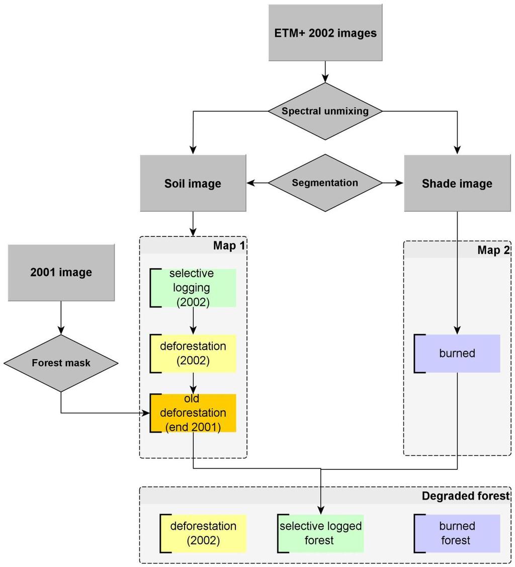
6 METHOD The proposed method is performed according to the following steps: - to generate a forest mask to prevent mapping areas already deforested before 2002; - to generate fraction images for all 2002 ETM+ images selected for this study; - to apply the image segmentation process to a multi-temporal dataset composed of soil and shade fraction images derived from ETM+ time series; - to generate map of selective logging and deforested areas for all analyzed soil fraction images; - to generate map of burned areas for all analyzed shade fraction images; - to combine the resulting two maps to generate the degradation forest areas due to selective logging and due to forest fire. 6
7 METHODOLOGICAL APPROACH 7


8 Fraction images enhance: Shade: forest canopy structure, water, and burned areas ETM+ 05 October 2002 Selective Logging Soil: bare soil, deforestation, and other non-photosynthetic materials Burned Clear cut Soil Fraction Image Vegetation: forest canopy, regrowth areas Shade Fraction Image 8


9 ETM+ 02 OCT 2001 DEFORESTATION MAP - INPE PRODES
10 ETM+ 15 June 2002 Mapping new deforested areas 10

11 ETM+ 15 June 2002 Mapping burned areas 11
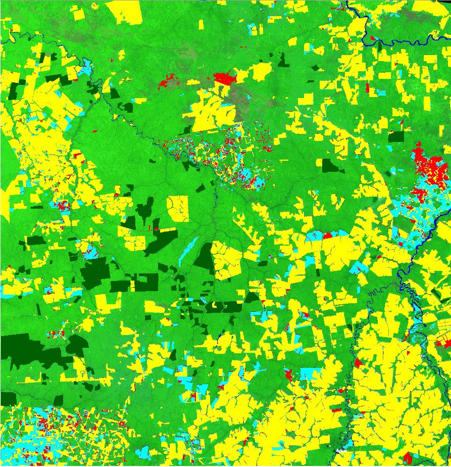
12 ETM Map of deforested areas ETM Map of burned and deforested areas 12

13 Forest degradation by fires 13

14 ETM Mapping selective logging areas ETM+ 17 July 2002 Soil Fraction Image 14
15 15
16 Estimated areas for the mapped classes in the study area CLASSES Old Deforestation Deforestation 2002 Degradation-logging Degradation-burning Forest Water AREA (km2) 6, (*) , Total 25,066 (*) Forest degradation due to selective logging is overestimated for the year 2002 since we have not masked the previous selective logging areas 16
17 CONCLUSIONS - Forest mask is essential for developing a procedure for detecting and mapping forest degradation areas. - Forest degradation due to selective logging can be detected and mapped using soil fraction images. - Forest degradation due to fires can only be mapped using time series images because burned areas can also be related to deforestation process when burning is used to clear the remaining vegetation. - The proposed method shows the potential to discriminate selective logging from burned forests within degraded forests, which is very important for estimation of carbon emissions. - The future availability of time series of high spatial resolution data (Sentinel-2) is expected to improve the assessment of deforestation and forest degradation processes and consequently facilitate implementing actions to protect the forest lands. 17
18 Thank you for your attention 18
Assessment of areas of selective logging and burned forests in Mato Grosso State, Brazil, from satellite imagery
 XIV WORLD FORESTRY CONGRESS, Durban, South Africa, 7-11 September 2015 Assessment of areas of selective logging and burned forests in Mato Grosso State, Brazil, from satellite imagery Yosio Edemir Shimabukuro
The ReCaREDD project
 The ReCaREDD project Brazil workshops Curitiba and São José dos Campos, 13 th 20 th April 2016 René Beuchle and Dario Simonetti http://forobs.jrc.ec.europa.eu/ 2016 This publication is a Conference and
CHARACTERIZATION OF THE AREAS IN SUCCESSION PROCESS (REGROWTH) IN THE AMAZON REGION
 IN THE AMAZON REGION") CHARACTERIZATION OF THE AREAS IN SUCCESSION PROCESS (REGROWTH) IN THE AMAZON REGION Iris de Marcelhas e Souza Iris@ltid.inpe.br Yosio Edemir Shimabukuro Yosio@ltid.inpe.br Valdete Duarte Valdte@ltid.inpe.br
CHARACTERIZATION OF THE AREAS IN SUCCESSION PROCESS (REGROWTH) IN THE AMAZON REGION Iris de Marcelhas e Souza Iris@ltid.inpe.br Yosio Edemir Shimabukuro Yosio@ltid.inpe.br Valdete Duarte Valdte@ltid.inpe.br
PRODES - INPE INPE. PRODES Methodology- PRODES Methodology - INPE. Mapping and Monitoring Deforestation and Forest Degradation in the Brazilian Amazon
 Mapping and Monitoring Deforestation and Forest Degradation in the Brazilian Amazon GOFC-GOLD GOLD Symposium on Forest and Land Cover Observations March 21st-26 26 th, 2006 Jena, Germany Carlos Souza Jr.
Remotely-Sensed Carbon and Water Variations in Natural and Converted Ecosystems with Time Series MODIS Data
 Remotely-Sensed Carbon and Water Variations in Natural and Converted Ecosystems with Time Series MODIS Data Alfredo Ramon Huete 1 Piyachat Ratana 1 Yosio Edemir Shimabukuro 2 1 University of Arizona Dept.
Detecting deforestation with multitemporal L-band SAR imagery: a case study in western Brazilian Amazônia
 INT. J. REMOTE SENSING INPE eprint: sid.inpe.br/eprint@80/2006/12.08.13.17 v1 2006-12-09 2006, 1 8, PrEview article Detecting deforestation with multitemporal L-band SAR imagery: a case study in western
A global perspective on land use and cover change
 A global perspective on land use and cover change Alan Belward The Global Environment Monitoring Unit Institute for Environment and Sustainability European Commission Joint Research Centre 21027 Ispra
Forest Transparency Brazilian Amazon
 Heron Martins, Antônio Fonseca; Carlos Souza Jr.; Márcio Sales & Adalberto Veríssimo (Imazon) SUMMARY In, SAD detected 84 km² of totaled 74.5 km² in. Compared to deforestation in the Legal Amazon with
Mapping the world s forests: work by FAO and partners in the global Forest Resource Assessment (FRA) Mette L. Wilkie Adam Gerrand FAO
 Mette L. Wilkie Adam Gerrand FAO") Mapping the world s forests: work by FAO and partners in the global Forest Resource Assessment (FRA) Mette L. Wilkie Adam Gerrand FAO www.fao.org/forestry/fra2010 Main points Challenges unprecedented global
Mapping the world s forests: work by FAO and partners in the global Forest Resource Assessment (FRA) Mette L. Wilkie Adam Gerrand FAO www.fao.org/forestry/fra2010 Main points Challenges unprecedented global
POTENTIAL IMPROVEMENT FOR FOREST COVER AND FOREST DEGRADATION MAPPING WITH THE FORTHCOMING SENTINEL-2 PROGRAM
 POTENTIAL IMPROVEMENT FOR FOREST COVER AND FOREST DEGRADATION MAPPING WITH THE FORTHCOMING SENTINEL-2 PROGRAM L. Hojas-Gascón a, d, A. Belward a, H. Eva a*, G. Ceccherini a, O. Hagolle b, J. Garcia c,
Near real time detection of deforestation in the Brazilian Amazon using MODIS imagery (doi: /ambi-agua.4)
") ISSN = 1980-993X doi:10.4136/1980-993x www.agro.unitau.br/ambi-agua E-mail: ambi-agua@agro.unitau.br Tel.: (12) 3625-4116 Near real time detection of deforestation in the Brazilian Amazon using MODIS imagery
ISSN = 1980-993X doi:10.4136/1980-993x www.agro.unitau.br/ambi-agua E-mail: ambi-agua@agro.unitau.br Tel.: (12) 3625-4116 Near real time detection of deforestation in the Brazilian Amazon using MODIS imagery
REDD-COMIFAC Meeting March 2008, Paris. REDD Pilot Project COMIFAC: Cameroon. T. Haeusler, S. Gomez
 REDD-COMIFAC Meeting 10-12 March 2008, Paris R e d u c i n g E m i s s i o n s f r o m D e f o r e s t a t i o n a n d D e g r a d a t i o n REDD Pilot Project COMIFAC: Cameroon T. Haeusler, S. Gomez Consortium
Detection of burned forests in Amazonia using the Normalized Burn Ratio (NBR) and Linear Spectral Mixture Model from Landsat 8 images
 and Linear Spectral Mixture Model from Landsat 8 images") Detection of burned forests in Amazonia using the Normalized Burn Ratio (NBR) and Linear Spectral Mixture Model from Landsat 8 images LAURA BARBOSA VEDOVATO 1 ALINE DANIELE JACON 1 ANA CAROLINA MOREIRA
Detection of burned forests in Amazonia using the Normalized Burn Ratio (NBR) and Linear Spectral Mixture Model from Landsat 8 images LAURA BARBOSA VEDOVATO 1 ALINE DANIELE JACON 1 ANA CAROLINA MOREIRA
New York Declaration on Forests
 Progress on the New York Declaration on Forests Technical Annexes Goal 1: At least halve the rate of loss of natural forests globally by 2020 and strive to end natural forest loss by 2030 November 2015
A North-American Forest Disturbance Record from Landsat Imagery
 GSFC Carbon Theme A North-American Forest Disturbance Record from Landsat Imagery Jeffrey Masek, NASA GSFC Forrest G. Hall, GSFC & UMBC Robert Wolfe, GSFC & Raytheon Warren Cohen, USFS Corvallis Eric Vermote,
Multitemporal Analysis of Degraded Forests in the Southern Brazilian Amazon
 Earth Interactions Volume 9 (2005) Paper No. 19 Page 1 Copyright 2005, Paper 09-019; 8,851 words, 5 Figures, 0 Animations, 5 Tables. http://earthinteractions.org Multitemporal Analysis of Degraded Forests
DLR contributions to R&D Support strategy (Element 3) Status update. Michael Bock, Helmut Staudenrausch SDCG-12 Session 4
 Status update. Michael Bock, Helmut Staudenrausch SDCG-12 Session 4") DLR contributions to R&D Support strategy (Element 3) Status update Michael Bock, Helmut Staudenrausch SDCG-12 Session 4 SDCG-12 Frascati September 5-7, 2017 TerraSAR/TanDEM-X Mission Status Satellite
DLR contributions to R&D Support strategy (Element 3) Status update Michael Bock, Helmut Staudenrausch SDCG-12 Session 4 SDCG-12 Frascati September 5-7, 2017 TerraSAR/TanDEM-X Mission Status Satellite
ROLES OF FOREST AND FORESTRY IN INDONESIA
 ROLES OF FOREST AND FORESTRY IN INDONESIA Mega biological diversity and one of the custodians of global peat land, Source of income and other customary uses for people live in and surrounding forests.
SENSIN. r il. el"" ("RN R E. Cl-ti, ,(ii) 28 OUÍ NYÕ. 15 ( (o. Taylor &Frailcis Publishers sit( I,. It~TIONAL JOURNA I 4 )F.
 28 OUÍ NYÕ. 15 ( (o. Taylor &Frailcis Publishers sit( I,. It~TIONAL JOURNA I 4 )F.") ISSN 0143-1161 el"" ("RN It~TIONAL JOURNA I 4 )F r il 11 I Lm, R E SENSIN Volume 17 Number 4 10 March 1996 15 (41 5.28 (o 28 OUÍ NYÕ,(ii) INPE SJC An official joumal of the Remote Sensing Society BIBLIOTECA
ISSN 0143-1161 el"" ("RN It~TIONAL JOURNA I 4 )F r il 11 I Lm, R E SENSIN Volume 17 Number 4 10 March 1996 15 (41 5.28 (o 28 OUÍ NYÕ,(ii) INPE SJC An official joumal of the Remote Sensing Society BIBLIOTECA
Optimal use of land surface temperature data to detect changes in tropical forest cover
 JOURNAL OF GEOPHYSICAL RESEARCH, VOL. 116,, doi:10.1029/2010jg001488, 2011 Optimal use of land surface temperature data to detect changes in tropical forest cover Thijs T. van Leeuwen, 1,2 Andrew J. Frank,
DMC 22m Sensors for Supertemporal Land Cover Monitoring. Gary Holmes DMC International Imaging Ltd June 2014
 DMC 22m Sensors for Supertemporal Land Cover Monitoring Gary Holmes DMC International Imaging Ltd June 2014 DMC 2 nd Generation Satellites UK-DMC2 and Deimos-1 launched 29 th July 2009 650km swath width
Monitoring forest degrada.on for REDD+: a primer
 Monitoring forest degrada.on for REDD+: a primer Mar%n Herold Wageningen University GOFC- GOLD/GFOI expert mee%ng 1. Oct. 2014 Some useful material FAO FRA/CPF special study on forest degradation 2010:
Towards the Improvement of National Forest Monitoring Approaches
 Towards the Improvement of National Forest Monitoring Approaches Arief Wijaya Center for International Forestry Research (CIFOR), Indonesia Contributors: Ruandha Agung Sugardiman, Budiharto, Anna Tosiani,
Fire Along the Transition Between the Amazon Forest and the Cerrado Ecosystems 1
 Fire Along the Transition Between the Amazon Forest and the Cerrado Ecosystems 1 Gustavo Hees de Negreiros 23, David Sandberg 4, Ernesto Alvarado 5, Thomas Hinckley 4, Daniel C. Nepstad 6, and Marcos Pereira
Remote Sensing of Environment
 RSE-07187; No of Pages 10 ARTICLE IN PRESS Remote Sensing of Environment xxx (2008) xxx-xxx Contents lists available at ScienceDirect Remote Sensing of Environment journal homepage: www.elsevier.com/locate/rse
User Awareness & Training: LAND. Tallinn, Estonia 9 th / 10 th April 2014 GAF AG
 User Awareness & Training: LAND Tallinn, Estonia 9 th / 10 th April 2014 GAF AG Day 2 - Contents LAND (1) General Introduction to EO and the COPERNICUS Sentinel Programme Overview of COPERNICUS/GMES LAND
EU-Africa collaboration on Space applications for Africa
 EU-Africa collaboration on Space applications for Africa Background Maputo Declaration: African policy makers request EC to open its GMES initiative to Africa (Oct 2006) Build on existing EO activities
Remote sensing in the REDD+ context lessons learned and way forward
 Remote sensing in the REDD+ context lessons learned and way forward Dr. Inge JONCKHEERE UN-REDD Team (FAO HQ Rome, Italy) Forest Monitoring Systems and Reference Levels for REDD+ October 2014 Hanoi, VietNam
Land Cover Classification in Amazon using Alos Palsar Full Polarimetric Data
 Land Cover Classification in Amazon using Alos Palsar Full Polarimetric Data Luciano Vieira Dutra Graziela Balda Scofield Sumaia Resegue Aboud Neta Rogério Galante Negri Corina da Costa Freitas Daniel
Linking Remote Sensing and Economics: Evaluating the Effectiveness of Protected Areas in Reducing Tropical Deforestation
 Linking Remote Sensing and Economics: Evaluating the Effectiveness of Protected Areas in Reducing Tropical Deforestation Joe Maher 1 and Xiaopeng Song 2 1 University of Maryland, Department of Agricultural
PROJECT INFORMATION DOCUMENT (PID) CONCEPT STAGE
 CONCEPT STAGE") PROJECT INFORMATION DOCUMENT (PID) CONCEPT STAGE Project Name Region Country Sector(s) Theme(s) Lending Instrument Project ID Borrower(s) Implementing Agency Environmental Category Date PID Prepared/ Updated
PROJECT INFORMATION DOCUMENT (PID) CONCEPT STAGE Project Name Region Country Sector(s) Theme(s) Lending Instrument Project ID Borrower(s) Implementing Agency Environmental Category Date PID Prepared/ Updated
Ten-Year Landsat Classification of Deforestation and Forest Degradation in the Brazilian Amazon
 Remote Sens. 2013, 5, 5493-5513; doi:10.3390/rs5115493 Article OPEN ACCESS Remote Sensing ISSN 2072-4292 www.mdpi.com/journal/remotesensing Ten-Year Landsat Classification of Deforestation and Forest Degradation
Remote sensing systems to monitor conversion areas
 Supported by Remote sensing systems to monitor conversion areas Lao-EU FLEGT VPA, Crowne Plaza, Seite 1 Supported by Contents 1 Monitoring of Conversion Areas 2 Optical Earth Observation 3 Forest Degradation
Novo Campo Program: Practicing Sustainable Cattle Ranching in the Amazon
 Novo Campo Program: Practicing Sustainable Cattle Ranching in the Amazon ICV: WHO WE ARE Civil Society Organization, based in Cuiabá, Mato Grosso State, founded in 1991 Mission: Build shared solutions
Bioenergy & Sustainability a SCOPE series volume Launching the report of a global assesment of bioenergy sustainability
 Environmental Security and Ecosystem Services: biodiversity, restoring soils and protecting ecosystems in bioenergy landscapes, harmonizing forestry and agriculture policies Mateus Batistella Embrapa Satellite
Do conservation incentives increase the effectiveness of protected areas?
 Introduction Do conservation incentives increase the effectiveness of protected areas? Elı as Cisneros, Jan Bo rner, Stefano Pagiola and Sven Wunder ZEF Bonn, ZEF Bonn, CIFOR Rio de Janeiro, World Bank
Mapping forest degradation in the Eastern Amazon from SPOT 4 through spectral mixture models
 Remote Sensing of Environment 87 (2003) 494 506 www.elsevier.com/locate/rse Mapping forest degradation in the Eastern Amazon from SPOT 4 through spectral mixture models Carlos Souza Jr. a,b, *, Laurel
K&C Science Report Phase 2 Application of ALOS/PALSAR in support to Brazilian Forest Monitoring Program
 K&C Science Report Phase 2 Application of ALOS/PALSAR in support to Brazilian Forest Monitoring Program Dalton M. Valeriano Instituto Nacional de Pesquisas Espaciais - INPE Caixa Postal 515-12245-970 -
Forest Monitoring in Tropical Regions
 Forest Monitoring in Tropical Regions Manuela Hirschmugl & Mathias Schardt Institute of Digital Image Processing, Joanneum Research Content: 1. Background 2. Data 3. Methods 3.1. Pre-processing 3.2. Segmentation
Deliverable 15 submitted to Biodiversity and Agricultural Commodities Program (BACP)
") Deliverable 15 submitted to Biodiversity and Agricultural Commodities Program (BACP) October, 2012 Aliança da Terra presentation Aliança da Terra (AT) is a Non-Governmental Organization formed by farmers,
Deliverable 15 submitted to Biodiversity and Agricultural Commodities Program (BACP) October, 2012 Aliança da Terra presentation Aliança da Terra (AT) is a Non-Governmental Organization formed by farmers,
Modeling the spatial and temporal heterogeneity of deforestation-driven carbon emissions: the INPE- EM framework applied to the Brazilian Amazon
 University of Nebraska - Lincoln DigitalCommons@University of Nebraska - Lincoln NASA Publications National Aeronautics and Space Administration 2012 Modeling the spatial and temporal heterogeneity of
Annual Deforestation Mapping in Sumatera using multi temporal digital classification
 Annual Deforestation Mapping in Sumatera 1990-2014 using multi temporal digital classification Kustiyo Remote Sensing Technology and Data Center LAPAN International Workshop on Land Use/Cover Change and
BRAZIL Ministry of Environment
 BRAZIL Ministry of Environment Combined safeguards and sub-regional capacity building workshop on REDD-plus, Quito, Ecuador, 5-8 July 2011 Natalie Unterstell, Focal Point for REDD+ at Secretariat on Climate
Applied Geography 58 (2015) 116e127. Contents lists available at ScienceDirect. Applied Geography. journal homepage:
 116e127. Contents lists available at ScienceDirect. Applied Geography. journal homepage:") Applied Geography 58 (2015) 116e127 Contents lists available at ScienceDirect Applied Geography journal homepage: www.elsevier.com/locate/apgeog Land cover changes in the Brazilian Cerrado and Caatinga
Applied Geography 58 (2015) 116e127 Contents lists available at ScienceDirect Applied Geography journal homepage: www.elsevier.com/locate/apgeog Land cover changes in the Brazilian Cerrado and Caatinga
Remote sensing as a tool to detect and quantify vegetation properties in tropical forest-savanna transitions Edward Mitchard (University of Edinburgh)
") Remote sensing as a tool to detect and quantify vegetation properties in tropical forest-savanna transitions Edward Mitchard (University of Edinburgh) Presentation to Geography EUBAP 10 th Oct 2008 Supervisor:
Remote sensing as a tool to detect and quantify vegetation properties in tropical forest-savanna transitions Edward Mitchard (University of Edinburgh) Presentation to Geography EUBAP 10 th Oct 2008 Supervisor:
Near real-time deforestation detection for enforcement of forest reserves in Mato Grosso
 Near real-time deforestation detection for enforcement of forest reserves in Mato Grosso Carlos M. de Souza Jr. -souzajr@imazon.org.br Sanae Hayashi - sanae@imazon.org.br Adalberto Veríssimo - betoverissimo@uol.com.br
Forest Biomass Change Detection Using Lidar in the Pacific Northwest. Sabrina B. Turner Master of GIS Capstone Proposal May 10, 2016
 Forest Biomass Change Detection Using Lidar in the Pacific Northwest Sabrina B. Turner Master of GIS Capstone Proposal May 10, 2016 Outline Relevance of accurate biomass measurements Previous Studies Project
Primary forest cover loss in Indonesia over
 SUPPLEMENTARY INFORMATION DOI: 10.1038/NCLIMATE2277 Primary forest cover loss in Indonesia over 2000 2012 Belinda Arunarwati Margono a c *, Peter V Potapov a, Svetlana Turubanova a, Fred Stolle b, Matthew
MaNIAC-UAV - a methodology for automatic pavement defects detection using images obtained by Unmanned Aerial Vehicles
 Journal of Physics: Conference Series PAPER OPEN ACCESS MaNIAC-UAV - a methodology for automatic pavement defects detection using images obtained by Unmanned Aerial Vehicles To cite this article: Luiz
REFERENCE DOCUMENT FOR THE DEVELOPMENT OF MATO GROSSO STATE S REDD PROGRAM
 REFERENCE DOCUMENT FOR THE DEVELOPMENT OF MATO GROSSO STATE S REDD PROGRAM EXECUTIVE SUMMARY An agricultural superpower that is controlling deforestation. A 903,000 km 2 state who: Is Brazil s leader in
Progress Meeting EO4SD Agriculture Cluster 4-5 October 2017 ESRIN, Frascati, Italy. Bolivia and Paraguay. Arjen Vrielink, Satelligence
 Progress Meeting EO4SD Agriculture Cluster 4-5 October 2017 ESRIN, Frascati, Italy Bolivia and Paraguay Arjen Vrielink, Satelligence Introduction Introduction Land tenure control issues (soy, livestock):
Implementation Status & Results Brazil Sustainable Cerrado Initiative (P091827)
") Public Disclosure Authorized Public Disclosure Authorized The World Bank Implementation Status & Results Brazil Sustainable Cerrado Initiative (P091827) Operation Name: Sustainable Cerrado Initiative (P091827)
Public Disclosure Authorized Public Disclosure Authorized The World Bank Implementation Status & Results Brazil Sustainable Cerrado Initiative (P091827) Operation Name: Sustainable Cerrado Initiative (P091827)
Development of Sub National FREL in West Kalimantan
 Development of Sub National FREL in West Kalimantan Hideyuki Kubo JICA Expert Indonesia Japan Project for Development of REDD+ Implementation Mechanism (IJ REDD+) 10 November 2016 Presentation 1. West
Sentinel-2 for agriculture and land surface monitoring from field level to national scale
 Sentinel-2 for agriculture and land surface monitoring from field level to national scale The on-going BELCAM, Sen2-Agri and LifeWatch experiences C. Delloye, S. Bontemps, N. Bellemans, J. Radoux, F. Hawotte,
TAKING STOCK OF OUR FORESTS
 Measurement, Reporting and Verification (MRV) systems are expected to be a crucial part of any future international climate agreement, including Reducing Emissions from Deforestation and forest Degradation,
resolution for the identification of many small areas deforested each year, like 1.1-km NOAA Advanced Very High Resolution, Radiometer (AVHRR)"
") THE AMAZONA NFORMATON SYSTEM Diogenes S. Alves (), Luiz Gylvan Meira Filho, Julio C. L. d'alge, Eliana K. Mello, Jos C. Moreira, Jose S. de Medeiros National nstitute for Space Research C.P. 515 - CEP
THE AMAZONA NFORMATON SYSTEM Diogenes S. Alves (), Luiz Gylvan Meira Filho, Julio C. L. d'alge, Eliana K. Mello, Jos C. Moreira, Jose S. de Medeiros National nstitute for Space Research C.P. 515 - CEP
Real-time crop mask production using high-spatial-temporal resolution image times series
 Real-time crop mask production using high-spatial-temporal resolution image times series S.Valero and CESBIO TEAM 1 1 Centre d Etudes Spatiales de la BIOsphre, CESBIO, Toulouse, France Table of Contents
FORMA: Forest Monitoring for Action
 FORMA: Forest Monitoring for Action FORMA uses freely-available satellite data to generate rapidly-updated online maps of tropical forest clearing. We have designed it to provide useful information for
Challenges to estimating carbon emissions from tropical deforestation
 Global Change Biology (2007) 13, 51 66, doi: 10.1111/j.1365-2486.2006.01272.x Challenges to estimating carbon emissions from tropical deforestation NAVIN RAMANKUTTY*w, HOLLY K. GIBBSw, FRÉDÉRIC ACHARDz,
Map accuracy assessment methodology and results for establishing Uganda s FRL
 Map accuracy assessment methodology and results for establishing Uganda s FRL 1 Table of Contents Acronyms... 4 1 Introduction... 5 2 Process and institutions involved... 5 3 Objectives of the map AA...
THE FRA 2010 REMOTE SENSING SURVEY
 Forest Resources Assessment Working Paper 155 THE FRA 2010 REMOTE SENSING SURVEY AN OUTLINE OF OBJECTIVES, DATA, METHODS AND APPROACH DECEMBER,2009 The Global Forest Resources Assessment Programme Sustainably
Brazil s submission of a Forest Reference Emission Level (FREL) for reducing emissions from deforestation in the Amazonia biome for REDD+
 for reducing emissions from deforestation in the Amazonia biome for REDD+") Brazil s submission of a Forest Reference Emission Level (FREL) for reducing emissions from deforestation in the Amazonia biome for REDD+ results-based payments under the UNFCCC Brasília, DF September,
Brazil s submission of a Forest Reference Emission Level (FREL) for reducing emissions from deforestation in the Amazonia biome for REDD+ results-based payments under the UNFCCC Brasília, DF September,
Amazon Deforestation
 Title Amazon Deforestation 40% increase between 2001 and 2002! Recent advert by Paddy Power. Read more on this story here Title Amazon Deforestation What is deforestation? 40% increase between 2001 and
Dynamic Maps of Open Surface Water Bodies in Oklahoma at 30- m Spatial Resolution during
 Dynamic Maps of Open Surface Water Bodies in Oklahoma at 30- m Spatial Resolution during 1984-2014 Xiangming Xiao Center for Spatial Analysis Earth Observation and Modeling Facility Department of Microbiology
Utilization of the SWAT Model and Remote Sensing to Demonstrate the Effects of Shrub Encroachment on a Small Watershed
 Utilization of the SWAT Model and Remote Sensing to Demonstrate the Effects of Shrub Encroachment on a Small Watershed Jason Afinowicz Department of Biological and Agricultural Engineering Texas A&M University
Afforestation, Reforestation and Deforestation
 JRC technical workshop 2014 on reporting LULUCF for CP2 with the IPCC 2013KP Supplement 5-7 May 2014, Arona Afforestation, Reforestation and Deforestation Marina Vitullo ISPRA - Institute for Environmental
Forest and Land Cover Monitoring by Remote Sensing Data Analysis
 Low Carbon Asia Research Network (LoCARNet) 3rd Annual Meeting Bogor, Indonesia November 24 26, 2014 Forest and Land Cover Monitoring by Remote Sensing Data Analysis Muhammad Ardiansyah Center for Climate
Mato Grosso in the context of global climate change
 Mato Grosso in the context of global climate change Area: 906,807 km² Population: 2,800,000 Capital: Cuiabá Mato Grosso in the context of global climate change MATO GROSSO: IN THE HEART OF SOUTH AMERICA
Rice crop monitoring using EO data in the Mekong Delta, Vietnam
 The 10th GEOSS Asia-Pacific Symposium WG5: Agriculture and Food Security Hanoi, 18-20 th, Sep. 2017 Rice crop monitoring using EO data in the Mekong Delta, Vietnam Lam Dao Nguyen, Hoang Phi Phung, Dang
Forestry Department Food and Agriculture Organization of the United Nations FRA 2000 GLOBAL FOREST COVER MAP. Rome, November 1999
 Forestry Department Food and Agriculture Organization of the United Nations FRA 2000 GLOBAL FOREST COVER MAP Rome, November 1999 Forest Resources Assessment Programme Working Paper 19 Rome 1999 The Forest
Pervasive Rise of Small-scale Deforestation in Amazonia
 www.nature.com/scientificreports Received: 14 July 2017 Accepted: 18 December 2017 Published: xx xx xxxx OPEN Pervasive Rise of Small-scale Deforestation in Amazonia Michelle Kalamandeen 1, Emanuel Gloor
Long-term trends and interannual variability of forest, savanna and agricultural fires in South America
 Carbon Management ISSN: 78-34 (Print) 78-32 (Online) Journal homepage: http://www.tandfonline.com/loi/tcmt2 Long-term trends and interannual variability of forest, savanna and agricultural fires in South
New pressures to reduce deforestation of the Brazilian Amazon
 New pressures to reduce deforestation of the Brazilian Amazon Paulo Barreto Senior Researcher IMAZON www.imazon.org.br E mail: pbarreto@imazon.org.br Presented at the Brazil Institute t Woodrow Wilson
Fertilizers in Brazil New opportunities
 Third International Conference on Slow- and Controlled- Release and Stabilized Fertilizers Fertilizers in Brazil New opportunities Rio de Janeiro March, 213 Index 1. Brazilian Agriculture Fertilizer Market;
Suitability of Global Forest Change data to report forest cover estimates at national level in Gabon
 Systèmes d Information à Référence Spatiale Suitability of Global Forest Change data to report forest cover estimates at national level in Gabon Expert workshop on using global datasets for national REDD+
30 Years of Tree Canopy Cover Change in Unincorporated and Incorporated Areas of Orange County,
 30 Years of Tree Canopy Cover Change in Unincorporated and Incorporated Areas of Orange County, 1986-2016 Final Report to Orange County July 2017 Authors Dr. Shawn Landry, USF Water Institute, University
MERIS Global Vegetation Index Land products. Nadine Gobron
 MERIS Global Vegetation Index Land products Nadine Gobron Contribution from: O. Aussedat, B. Pinty, M. Taberner, F. Mélin, T. Lavergne, M. Robustelli, M.M. Verstraete & J.-L. Widlowski (JRC). O. Faber
A Panamazonian Model of Forest Fire, Agricultural Expansion, and Logging: Amazon Scenarios
 A Panamazonian Model of Forest Fire, Agricultural Expansion, and Logging: Amazon Scenarios WHRC: D. Nepstad, L. Solorzano, P. Lefebvre, P. Schlesinger, G. Carvalho, D. McGrath, F. Brown, A. Hirsch IPAM:
Aliança da Terra. Producers for Biodiversity
 Aliança da Terra Contents Producers for Biodiversity Contents... 1 Overview... 1 Project Objectives... 2 Major steps taken... 3 Challenges and barriers... 5 Project Impact... 6 Lessons Learned... 9 Next
Observing terrestrial variables for climate: achievements and opportunities
 Observing terrestrial variables for climate: achievements and opportunities Martin Herold Wageningen University, GOFC-GOLD Joint GCOS, UNFCCC, IPCC workshop 10. Febr. 2015 Essential Climate Variables (terrestrial)
Integration methods for forest degradation assessment and change monitoring
 VTT TECHNICAL RESEARCH CENTRE OF FINLAND LTD Joint GFOI / GOFC-GOLD / CONABIO / SilvaCarbon R&D Expert and Capacity Building workshop on: Regional solutions to forest type stratification and characterising
Land cover and land use in Brazil and the Environmental-Economic Accounts System
 Land cover and land use in Brazil and the -Economic Accounts System Rodrigo de Campos Macedo 1, Maurício Zacharias Moreira 2, Eloisa Domingues 3, Ângela Maria Resende Couto Gama 4, Fábio Eduardo de Giusti
STUDY OF THE VEGETAL COVERING AND LAND USE DYNAMICS IN THE REGION OF JI- PARANÁ/RO USING CLASSIFICATION TECHNICS
 STUDY OF THE VEGETAL COVERING AND LAND USE DYNAMICS IN THE REGION OF JI- PARANÁ/RO USING CLASSIFICATION TECHNICS Nilo Sergio de Oliveira Andrade *, Luciana Spinelli Araujo **, Izaya Numata **, Mário Valerio
Monitoring Trends in Burn Severity (MTBS) Project Overview
 Project Overview") Monitoring Trends in Burn Severity (MTBS) Project Overview Adrian Grell US Forest Service Remote Sensing Applications Center Webinar for the Northern Rockies Fire Science Network February 6, 2013 Consistently
Monitoring Trends in Burn Severity (MTBS) Project Overview Adrian Grell US Forest Service Remote Sensing Applications Center Webinar for the Northern Rockies Fire Science Network February 6, 2013 Consistently
Existing products and tools for country support
 NFMS and MRV FAO Forestry Existing products and tools for country support FAO Forestry www.fao.org/forestry Country Level HQ Level NFMS/MRV cooperation and coordination at HQ and national level P&Ms UN-REDD
SESSION 2 - Working Groups
 REDD+ FOR THE GUIANA SHIELD Technical Cooperation Project SESSION 2 - Working Groups Sérgio Milheiras & Marie Calmel, ONF International 02 June 2014 3 rd SC meeting - Cayenne, French Guiana Capacity Building
ANTHROPIZATION DYNAMICS OF THE CERRADO (BRAZILIAN SAVANNA) IN THE URUÇUÍ-UNA ECOLOGICAL STATION, BRAZIL, BASED ON ORBITAL IMAGES FROM 2003 TO 2005
 IN THE URUÇUÍ-UNA ECOLOGICAL STATION, BRAZIL, BASED ON ORBITAL IMAGES FROM 2003 TO 2005") ANTHROPIZATION DYNAMICS OF THE CERRADO (BRAZILIAN SAVANNA) IN THE URUÇUÍ-UNA ECOLOGICAL STATION, BRAZIL, BASED ON ORBITAL IMAGES FROM 23 TO 2 Alfredo Pereira 1 Verônica Fernandes Gama 2 1 Agronomic Engineer
ANTHROPIZATION DYNAMICS OF THE CERRADO (BRAZILIAN SAVANNA) IN THE URUÇUÍ-UNA ECOLOGICAL STATION, BRAZIL, BASED ON ORBITAL IMAGES FROM 23 TO 2 Alfredo Pereira 1 Verônica Fernandes Gama 2 1 Agronomic Engineer
Tiger project #2 : Biomass evaluation of tropical dry and wet forests. Climate change impacts
 Tiger II Workshop Hartebeeshoek, South Africa, 12 13 December 2011 Tiger project #2 : Biomass evaluation of tropical dry and wet forests. Climate change impacts Laboratory Institution Partners Project
By Gerald Urquhart, Walter Chomentowski, David Skole, and Chris Barber
 By Gerald Urquhart, Walter Chomentowski, David Skole, and Chris Barber The clearing of tropical forests across the Earth has been occurring on a large scale basis for many centuries. This process, known
SENGEF - XI Seminário de Atualização em Sensoriamento Remoto e Sistemas de Informações Geográficas Aplicados à Engenharia Florestal.
 Mapas de carbono da Amazônia dos dados globais IPCC tier 1 para uma abordagem regional tier 2 da Comunicação Nacional do Brasil à Convenção-Quadro das Nações Unidas sobre Mudança do Clima Amazon forest
BIOEN Research Workshop
 BIOEN Research Workshop D i v i s i o n s o f B i o m a s s, I m p a c t s a n d S u s t a i n a b i l i t y S ã o P a u l o, 0 6 N o v e m b e r 2012 Environmental and socioeconomic impacts associated
RESTORE+: Addressing Landscape Restoration for Degraded Land in Indonesia and Brazil. Picture credit Stora Enso
 RESTORE+: Addressing Landscape Restoration for Degraded Land in Indonesia and Brazil Picture credit Stora Enso IMPORTANCE OF RESTORATION Bonn Challenge and Global Partnership on Forest Landscape Restoration
Afforestation Reforestation
 Afforestation Reforestation Seminar on Business Opportunities of Climate Change Mitigation in Sri Lanka Towards Post-Kyoto Era 21 st July 2011 JICA Expert Team Shiro Chikamatsu Objectives of the Seminar
Zambia s National Forest Monitoring System
 Zambia s National Forest Monitoring System Deuteronomy Kasaro 1 and Julian Fox 2 1. REDD+ National REDD+ Coordinator deutkas@yahoo.co.uk 2. UN-REDD MRV facilitator Julian.fox@fao.org ZAMBIA Programme Goal:
FREL for REDD+ Nguyen Dinh Hung, FIPI, Viet Nam GFOI Plenary 2017, Ho Chi Minh City, 12 April 2017
 FREL for REDD+ Nguyen Dinh Hung, FIPI, Viet Nam GFOI Plenary 2017, Ho Chi Minh City, 12 April 2017 FREL overview Final report of TA 2015 - Preparation FREL submitted to UNFCCC Jan. 2016 National FREL submitted
A look past and a look forward. David Skole Michigan State University
 A look past and a look forward David Skole Michigan State University Antecedents ca. 1988-94 There were important antecedents to the NASA LCLUC program Two important drivers: Large scale Landsat databases
Available online at Received 15 November 2006; received in revised form 18 July 2007; accepted 21 July 2007
 Available online at www.sciencedirect.com Remote Sensing of Environment 112 (2008) 1969 1981 www.elsevier.com/locate/rse Deforestation in Central Africa: Estimates at regional, national and landscape levels
CASE STUDIES ON MEASURING AND ASSESSING FOREST DEGRADATION INTEGRATING FOREST TRANSECTS AND REMOTE SENSING DATA
 Forest Resources Assessment Working Paper 161 CASE STUDIES ON MEASURING AND ASSESSING FOREST DEGRADATION INTEGRATING FOREST TRANSECTS AND REMOTE SENSING DATA TO QUANTIFY CARBON LOSS DUE TO FOREST DEGRADATION
Current Status of NFMIS in Myanmar & How MOLI data can Contribute to the ongoing Efforts. Myat Su Mon, Forest Department, Myanmar
 Current Status of NFMIS in Myanmar & How MOLI data can Contribute to the ongoing Efforts Myat Su Mon, Forest Department, Myanmar 26-05-2017 1 Presentation Outlines Background Information Challenges for