Silviculture Best Management Practices 2017 Implementation Survey Report
|
|
|
- Hester Tate
- 6 years ago
- Views:
Transcription


1 Silviculture Best Management Practices 2017 Implementation Survey Report
2 Results of Florida s 2017 Silviculture BMP Implementation Survey Conducted by: Florida Department of Agriculture and Consumer Services Florida Forest Service In Cooperation with Florida Forest Landowners and Forest Land Managers January, 2018 Jeff Vowell, Forest Hydrologist Roy Lima, BMP Forester Robin Holland, BMP Forester For more information, Contact: Florida Forest Service 3125 Conner Boulevard Tallahassee, Florida (850)
3 EXECUTIVE SUMMARY In 2017, the Florida Department of Agriculture and Consumer Services Florida Forest Service (FFS) completed the nineteenth Survey on Silviculture Best Management Practices (BMPs). By delegation from the Florida Department of Environmental Protection, the FFS is the lead agency for statewide development, implementation, and monitoring of silviculture BMPs. This Survey fulfills the implementation monitoring element of the FFS responsibility for controlling silviculture related sources of nonpoint pollution. The Silviculture BMP Implementation Survey was initiated in 1981 and has since been conducted biennially. The principal purpose of the Survey is to determine the level of implementation with Florida's Silviculture BMPs. The Survey is conducted throughout Florida from a random sample of recent forestry operations. Both public and private forest lands that meet the selection criteria are eligible for the Survey. The Survey process is consistent with the Southern Group of State Foresters Silviculture Best Management Practices Implementation Monitoring - A Framework for State Forestry Agencies (June 2002). In addition, results from a BMP Effectiveness Study published in 2001 and 2004 (References), used the Survey as a measure of BMP implementation and stream bio-assessment techniques to measure water quality. These stream bioassessment studies concluded that where silviculture BMPs were properly applied (as measured by the Survey), water quality, aquatic habitat and overall stream ecosystem health were protected. The 2017 BMP Implementation Survey evaluated 3,074 practices on 163 individual forestry operations (sites). This cooperative effort involved 108 individual public and private landowners and covered 34,492 acres in 44 Florida counties. Eighty-two sites were on private non-industrial forestland, 55 on industrial forestland, and 26 on public forestlands. The 2017 Survey reported no instances of noncompliance that constituted a significant risk to water quality. For the 2017 Survey, no site scored below 86% in overall BMP implementation. Ninety-six percent of the sites scored 100% implementation for applicable BMPs, an increase of 6% from the 2015 survey. The range of compliance scores was 86% to 100%, and the average for overall BMP compliance was 99.6%, a slight increase from 99.3% in The average compliance for the 36-year period since 1981 is 95%, and a total of 5,859 individual forestry operations have been surveyed during the period of record. 2
4 INTRODUCTION Florida's Silviculture Best Management Practices (BMP) Program was established as a result of the 1972 Federal Water Pollution Control Act (a.k.a. Federal Clean Water Act). This program is directed at controlling nonpoint source (NPS) pollution associated with forestry operations, through the use of BMPs. Under delegation by the Department of Environmental Protection's State Water Quality Program, the Florida Forest Service (FFS) is responsible for the development, implementation, and monitoring of forestry BMPs in Florida. The purpose of this report is to present the results of the most recent implementation monitoring, as determined by the 2017 BMP Implementation Survey. BMP Development Florida's first Silviculture BMP Manual [1] was published in 1979 and was revised multiple times over the years, the most recent being in The BMP revision process is conducted by a 22 member Technical Advisory Committee appointed by the Commissioner of Agriculture and composed of representatives from state and federal government, forest industry, private nonindustrial landowners, conservation/environmental groups and academia [2]. The BMP Manual [3] contains 150 individual practices within fourteen BMP categories, including "Special Management Zones" and Wetlands that protect overall ecosystem integrity and wildlife habitat, as well as water quality. In addition, the Technical Advisory Committee continues to meet biennially to consider revisions to the Manual and provide input and guidance for the overall BMP program. The most recent Technical Advisory Committee meeting was May 11, 2017 at which time a BMP status and progress report was presented. BMP Implementation Implementation of silviculture BMPs in Florida is primarily done under an educational format, designed to transfer BMP technology to forest practitioners through workshops and field demonstrations. The implementation program is ongoing, with workshops routinely provided upon request or as deemed necessary based on monitoring results. Currently, FFS BMP foresters conduct twenty to thirty workshops/demonstrations annually, involving over 600 participants per year. In addition, the FFS provides BMP training directly to loggers through the Florida Forestry Association s Master Logger Program. To date, approximately 476 loggers have attended this training and become Master Loggers. BMP Monitoring Since 1981, the Florida Forest Service has monitored forestry operations for compliance with BMPs by conducting biennial Surveys. The Survey evaluates a random sample of forestry operations for compliance with all applicable BMPs. Forestry operations that meet specific criteria on both public and private lands are eligible for the Survey. For the period of record (1981 to 2017), the FFS has evaluated over 5,800 individual forestry operations and recorded statewide compliance rates ranging from 84% (1985) to 99.6% (2017). For the period of record, the cumulative statewide average for overall compliance with silviculture BMPs is 95%. 3
5 The 2017 Survey was the nineteenth statewide BMP monitoring effort since In addition, a BMP Effectiveness Study was initiated in 1996, using the Survey as a measure of BMP implementation and Florida s Stream Condition Index [4] as the principal measure of water quality. The study evaluated BMP effectiveness during silviculture operations such as clearcut harvesting, intensive mechanical site preparation and forest chemical (herbicides and fertilizer) application. Upon completion, the results of the study showed that properly applied silviculture BMPs were effective in protecting water quality, aquatic habitat and overall stream ecosystem health [5, 6]. Several additional forestry BMP studies have been conducted since then looking specifically at fertilizer application and its impact on ground water and surface water. These studies have also shown that properly implemented BMPs protect both ground water and surface water from contaminants associated with fertilizer use [7,8]. Sampling Intensity and Site Selection SURVEY PROCEDURE The BMP Implementation Survey is conducted in Florida counties where any level of bona-fide silviculture activity is reported or observed. As in previous Surveys, each county within the 2017 sample area was assigned a sampling goal (number of Survey sites) proportionate to that county s average annual timber removal [9]. Thus, the more timber removed, the higher the goal assigned to the county. For example, the high level of timber removal in Taylor County resulted in a goal of 11 sites; whereas Bradford County s relatively low timber removals resulted in a goal of one site. In addition, in order to sample as much of the state's geographic area as possible, counties showing any significant timber harvest activity, were assigned a goal of at least one site. This resulted in a total goal of 210 sites for the 2017 Implementation Survey [Appendix Table 1]. Candidate sites for the 2017 Survey were selected using the following criteria: (1) the operation must be bona-fide silviculture, (2) the silviculture treatment being evaluated must have occurred within the past two years, and (3) some part of the treatment must have occurred within 300 feet of a stream, sinkhole or lake (2 acres or larger), or within a wetland type listed in the BMP Manual. These criteria provide for Survey sites where the greatest potential for forestry-related non-point source (NPS) pollution exists, and where any such impacts are still discernible and measurable at the time of the Survey. Sites for the 2017 Survey were selected by FFS personnel, from fixed-wing aircraft, flying randomly selected township and range lines at altitudes ranging from feet. This pattern was flown for each county until the established goal was attained to minimize sample bias and to maximize the diversity of ownerships and physiographic areas within the sample. In areas where aircraft were not available, candidate sites were selected from the ground, assigned a number, and then drawn randomly. By these methods, candidate sites were identified in 44 counties in the spring/summer/fall of Upon verification of ground conditions on candidate sites, 163 sites in 44 counties were confirmed as meeting the qualifying criteria. 4
6 In addition to the 163 sites identified as bona-fide Silviculture, FFS personnel also observed sites which appeared to be forestry operations but after close inspection on the ground, were determined to be associated with a non-forestry land use. Site Evaluation After being selected and verified for the Survey, each site was evaluated for compliance with all applicable BMPs. The evaluation was conducted in the field by the BMP foresters who were responsible for contacting landowners prior to visiting each site to secure access and to solicit their participation in the Survey. Actual field evaluations were only conducted on those sites that met the selection criteria and where silviculture activities were bona-fide. Timber harvesting associated with land clearing operations intended for development or other non-forestry land uses were not included in the Survey. The process of evaluating each site involved observing as much of the treated area as possible and completing a Survey field questionnaire [Appendix Table 2]. The questionnaire consists of 150 specific, YES or NO questions directly related to BMP implementation. All answers were based on physical on-site evidence with no assumptions made about future activities. BMP implementation was evaluated and scored at three levels on each site: (1) individual practice(s); (2) categories of practices; and (3) overall. For an individual practice, implementation was recorded as either a Yes, No or Not Applicable. For categories of practices, such as Forest Roads or Stream Crossings, and for the overall score, implementation was expressed as a percent of all applicable BMPs in that category. Hence, each Survey site was given a compliance score between 0% and 100% for each applicable BMP category and for the overall site. In addition, each incidence of non-compliance at the practice level was further evaluated in terms of "significant risk" to water quality. Significant risk is defined as "a situation or set of conditions where noncompliance with BMPs has resulted, or may result, in the measurable and significant degradation of physical, chemical, or biological integrity of water quality, to the extent that it presents an imminent and substantial danger to the designated beneficial use. Where a significant risk has been identified, the observer makes recommendations to the landowner, logger, or contractor for corrective measures. After a reasonable period of time, a follow up site evaluation is made to assess compliance with these measures. Willful noncompliance with recommendations will initiate referral to the appropriate regulatory agency for enforcement action. 5
7 DISCUSSION OF RESULTS For the 2017 BMP Implementation Survey, FFS personnel evaluated 3,074 practices, on 163 individual forestry operations in 44 Florida counties. Of the individual practices evaluated, 3,063 (99.6%) were found to be in 100% compliance with BMPs. This level of implementation is a slight increase of 0.30% from the 2015 Survey results. (Figure 1). Statistical Analysis Compliance % Figure 1. BMP Implementation by Survey Year As in previous 90 Surveys, the practices evaluated represent 85 only a sample of all forestry operations that met the qualifying 80 criteria for In that regard, the Survey Survey Year represents an estimate of the actual compliance with silviculture BMPs. Based on the sampling procedure employed [10], the statistical properties below are attributable to the Survey data and express the quality of the estimate: Estimate of Implementation (f): Standard Error (se): 95% Confidence Interval (ci): f = BMPs in compliance/bmps evaluated(n) se = f(1-f)/n ci = f + 2 se f = 3063/3074 se = 0.996( )/3074 ci = (.001) f = se = ci = 99.4% % For 2017, the estimate of BMP implementation (f) for the 44 county area is 99.6%, with an estimated standard error (se) of Using the 95% confidence interval (ci), the data indicates that 95% of the time it is reasonable to expect compliance with BMPs to be at least 99.4% but not more than 99.8%. 6
8 Number of Survey Sites Figure 2. Distribution of Implementation Scores < 70% 70-79% 80-89% 90-99% 100% Categories of Implementation Levels Implementation scores for individual Survey sites in 2017 ranged from a low of 86.7% to a high of 100%. Figure 2 indicates the distribution of scores for individual Survey sites within several categories of implementation levels. Scores for individual BMP categories ranged from 99.8% for Forest Roads to 100% for Canals, Fireline Construction, Pesticide and/or Fertilizer Use, Wet Weather Operations, Wetlands, Stream Crossings, Timber Harvesting, Emergency Operations, and Public Lands. (Appendix Table 2). The total number of individual practices evaluated in 2017 decreased by 11% from the 2015 Survey due to a decrease in the number of actual sites sampled. However, increases in the number of practices evaluated within individual BMP categories were noted for Canals (29 to 44), and Emergency Operations (3 to 7). Site Characteristics As in all previous Surveys, pine flatwoods with poorly drained soils, which characterize a large portion of Florida's landscape, dominated the physiographic types evaluated in Eighty-nine percent of the sites evaluated were pine plantations, 7% of the sites were reported as natural pine/hardwood mix, and 3% wetlands. Soil erodibility was reported as high on 2% of the Survey sites, while 89% of the sites reported low erosion potential. The primary tree species harvested on the Survey sites was slash pine (68%), followed by loblolly pine (25%), longleaf (3%), hardwoods (11%) and cypress (3%). Compared to the 2015 Survey, hardwood removals decreased by 44% and cypress harvesting decreased by 40%. Similar to past Surveys, perennial and intermittent streams dominated the water resource features associated with the 2017 Survey sites at 89%. Wetland dominant terrain was identified on 3% of the sites. No lakes or sinkholes were noted. Also, seventy-three per cent of the 2017 Survey sites involved clearcut harvesting operations, mostly in intensively managed pine plantations. Selective harvesting and seed tree operations were evaluated on 11% of the sites. There were nine salvage harvest sites evaluated resulting from insect and wildfire damage. The 2017 Survey also collected information pertaining to logger training. On sites where timber harvesting was evaluated, 95% of the loggers were Florida Master Loggers, 2% were Georgia Master Timber Harvesters, and 3% were Alabama Pro Loggers. In addition, information was collected concerning wood flow to paper mills, sawmills, veneer plants and pole treatment facilities. The results show 51% of the timber harvested was delivered to pulp and paper mills, 40% to chip n saw mills, 2% to veneer facilities, and 7% to pole treatment plants. 7
9 Forestland Ownership For 2017, 50% of the Survey 90 sites were located on private 80 non-industrial forest lands 70 (PNIF), 34% on forest industry 60 lands, and 16% on public lands. 50 This represents a shift in the 40 distribution of sites by 30 ownership, particularly with respect to the private nonindustrial sector. Since 2015, industry land has made a turnaround and showed an increase in activity along with private non-industrial forest PNIF Survey Year Industry Public land which continues an upward trend (Figure 3). Public land has also trended upward since 2015, showing a 45% increase in activity. These changes and trends are no doubt linked to changes in land ownership, economic pressures, and market conditions for forest products. Seventy-two percent of the PNIF landowners that participated in the 2017 Survey indicated that they received some level of technical assistance during their forestry operations. However, the use of technical assistance did not significantly increase overall implementation scores compared to landowners who did not use technical assistance. In addition, overall implementation was not substantially different between ownership categories. BMP implementation indicated that compliance on industry land was 99.9%, private non-industrial forest land was 99.6%, and public land was Silviculture BMP Notice of Intent Percent Figure 3. Survey Sites by Ownership Forestry Rule 5I-6 F.A. C. was adopted on February 11, 2004 and entitles forest landowners to a presumption of compliance with state water quality standards if they file a Notice of Intent (NOI) to implement BMPs during their silvicultural operations. Filing a NOI is completely voluntary, and will increase a landowner s protection against state water quality standards violations, should one occur as a result of silviculture operations. Both public and private forest landowners can file a NOI by submitting a two-page form to the Florida Forest Service s Hydrology Section in Tallahassee. As of January 2018, the FFS has received NOIs that encompass more than 5.1 million acres, ranging from small private nonindustrial landowners to large industrial ownerships (Figure 4). 8
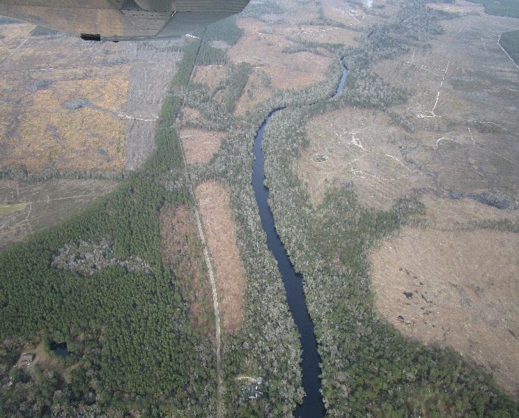
10 6,000,000 Figure 4. Silviculture BMP Notice of Intent Cumlative Acres Enrolled Since ,000,000 4,000,000 3,000,000 2,000,000 1,000,000 Acres 0 PNIF Industry Public Special Management Zones Research has shown that the area immediately adjacent to streams, lakes and other waterbodies is especially important in the overall strategy to protect water quality during silviculture operations. For example, one Florida study reported that increased suspended sediment levels in [forest land] runoff water during the treatment year [was] mostly due to the absence of a protective buffer zone along the drainage [11]. The Silviculture BMP Effectiveness Study mentioned earlier, also showed the importance of stream riparian areas for protecting water quality and for providing habitat requirements for aquatic organisms [5, 6]. In Florida's Silviculture BMP Manual, these riparian areas are referred to as Special Management Zones (SMZ) and apply to all streams, sinkholes, and lakes two acres and larger. In fact, the presence of such water resource features and/or the presence of wetlands are the principal criteria for a forestry operation to qualify as a Survey site. As stated in the Silviculture Best Management Practices Manual, SMZs are designed to protect water quality by reducing or eliminating forestry related inputs of sediment, nutrients, logging debris, chemicals and water temperature fluctuations that can adversely affect aquatic communities. SMZs provide shade, streambank stability and erosion control, as well as detritus and woody debris, which benefit the aquatic ecosystem in general. In addition, the SMZ is designed to maintain certain forest attributes that will provide specific wildlife habitat values. Implementation of the SMZ includes one or more of the following components: Primary Zone, Secondary Zone, and Stringer. The Primary Zone applies to perennial waters and ranges in width from 35 to 200 feet, depending on stream width and waterbody type. The Secondary Zone and Stringer apply mostly to intermittent waters. For a given waterbody, the total SMZ width is always a minimum of 35 feet, and may extend out to as much as 300 feet. The management criteria that apply within each SMZ component are based on the soil and slope of the site and on the size, nature, and classification of the waterbody involved. 9
11 Figure 5. Primary Zone Miles and Acres by Survey Year Cumlative Number of Miles in Primary Zone Cumlative Number of Acres in Primary Zone One-hundred percent of all water resource features reported in the Survey were streams. Fifty-two percent perennial streams and forty-eight percent intermittent streams were evaluated for SMZ compliance on 66 sites in the 2017 Survey. As in past Surveys, the perennial stream category was dominated by streams less than 20 feet wide, which require a minimum 35 foot Primary Zone. For 2017, the actual measured Primary Zone widths for these size streams ranged from feet, with an average width of 113 feet which is an increase of 14 feet from the 2015 survey. For perennial streams, the Survey reported 18.8 total stream miles meeting Primary Zone requirements. Forest industry lands accounted for 10.4 miles, with PNIF and Public Lands accounting for 4.4 and 4.0 miles, respectively (Figure 5). The total area reported as being under Primary Zone management for 2017 was 279 acres, and sixty-two percent of all SMZs evaluated were on small, first order streams. The average implementation rate for all three SMZ components was unchanged at 99% for 2017 (Table 1). No significant risks to water quality were reported. 10
12 Table 1: SMZ Implementation Summary for last six surveys SMZ Component Primary Zone 100% 99% 98% 97% 97% 98% Secondary Zone 98% 100% 97% 100% 98% 98% Stringer 98% 100% 98% 98% 98% 99% Average Compliance 99% 99% 98% 98% 98% 98% Wetland Forestry Operations Wetland BMPs address forestry operations such as timber harvesting and skidding practices conducted within wetlands, and certain activities adjacent to isolated wetlands such as intensive site preparation and pre-suppression fireline construction. Wetland forestry operations were evaluated on 7% of the sites during the 2017 Survey, unchanged from the 2015 Survey. Twenty-nine percent of the sites were evaluated for wet weather operations. Eighty-two percent of all sites evaluated for Wetland BMPs in 2017 involved operations conducted in wetland areas less than 200 acres. Within the 44 county area sampled, 129 wetland practices were evaluated on 11 sites and 100% of those were in full compliance with BMPs. Forest Roads and Stream Crossings Historically, the most chronic and long-term sediment problems associated with silviculture are directly attributable to forest roads. Consequently, the proper planning, construction, drainage, maintenance, and application of forest road BMPs help prevent forestry-related water quality problems. For 2017, Forest Road BMPs were evaluated on 156 sites most of which involved maintenance of existing roads. Of the 612 road practices evaluated, 99.8% were in full compliance with BMPs. Four survey sites (3%) reported newly established roads. New road construction was found to be in compliance with BMPs 99.8% of the time. Likewise, existing drainage structures were evaluated on 117 sites and had a compliance rate of 100%. As in previous surveys, the most common incidence of noncompliance for roads was failure to properly stabilize road banks and critical road segments in addition to cleaning out drainage structures (i.e. culverts, cross ditches, etc.) from major obstructions. Stream Crossings associated with forestry operations were evaluated on 12% of the Survey sites in Of the stream crossings evaluated, 55% were culvert installations and the remainder was hardsurface crossings. Of the 166 Stream Crossing practices evaluated in the 2017 Survey, 100% were in compliance with BMPs a slight increase of 1.2% compared to the 2015 Survey. 11
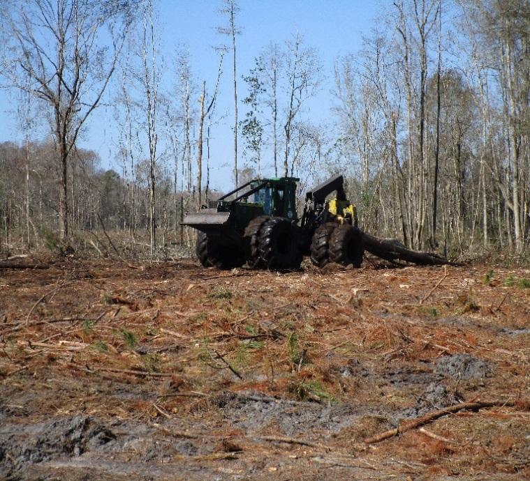
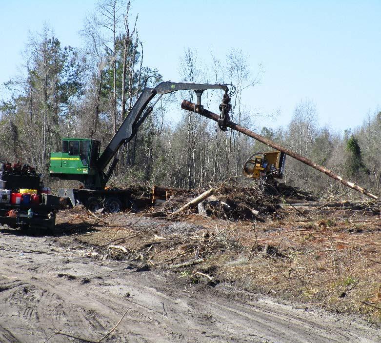
13 Timber Harvesting, Site Preparation and Planting The number of timber harvesting practices evaluated in 2017 totaled 523 on 130 sites. Overall implementation for this category was 100% for the 44 county area surveyed. No significant risks were observed on any of the 130 sites associated with timber harvesting BMPs. Second only to Timber Harvesting, Site Preparation is the most common and recognizable silviculture operation in Florida forestry. Mechanical site preparation, such as chopping, bedding and pile raking, routinely follows harvesting operations in pine management and often results in a significant amount of bare soil exposure. For that reason, the orientation of such activities with respect to slope and local surface waters is the basis for most BMPs in the Site Preparation category. The intensity and timing of site preparation largely determines the extent of soil exposure, while slope and soil type determine erosion potential. Florida s Silviculture BMP Manual uses a Site Sensitivity Classification system to describe the susceptibility of a site to erosion and sedimentation. Generally, sites with slopes exceeding 12%, adjacent to the waterbody, are considered most susceptible to erosion and require wider SMZs with restrictions on mechanical site preparation activities. Similar to previous Surveys, only 1% of the 2017 sites fell within this slope class and 74% were classified as having low (<2%) soil erodibility. Site preparation and tree planting activities were evaluated on 48% of the 2017 Survey sites. Overall implementation for this category was 99.2% for the 44 county area surveyed. Sixty percent of the sites evaluated for site preparation incorporated some type of mechanical operations. Of those sites reporting mechanical site preparation, 42% involved intensive shearing, raking, pile raking, and/or bedding. Chemical site preparation, alone or in combination with mechanical techniques, was reported on 58% of the 2017 sites. Site preparation and planting operations scored 99.2% overall for sites sampled within the 44 county area. Tree planting activities were evaluated on 79 sites and involved machine planting 51% of the time. Fireline Construction The number of sites evaluated for fireline construction was 4 in 2013, 5 in 2015, and 4 in In addition, the overall implementation rate for this category was 100% in this Survey, unchanged from Waste Disposal The Waste Disposal category continues to be a high priority for BMP implementation on forestland in Florida. In particular, the proper disposal of forestry related petroleum and chemical products and their containers is an increasingly important surface and ground water concern. Waste Disposal BMPs were evaluated on 163 sites during the 2017 Survey. Although implementation for this category was 99.7%, two sites (1%) scored less than 80%. Most other instances of BMP noncompliance for this category were solid waste (trash), empty oil containers, and hydraulic fluid containers near log loading decks. 12
14 Significant Risk Each incidence of BMP noncompliance was further evaluated in terms of Significant Risk to water quality. This element of the Survey was added in 1995 so that high-risk Figure 6. Comparison of Significant Risk conditions could be identified and by Survey Year corrected. In addition, this 10 evaluation provides a measure of the 5 frequency with which such 0 conditions may occur in conjunction with silviculture operations in Survey Year Florida. Of the 3,074 practices evaluated, there were no significant risks reported for the 2017 Survey. Figure 6 indicates the number of significant risks, by Survey, since Significant Risks SUMMARY The 2017 BMP Implementation Survey was the nineteenth since the initial Survey in 1981, marking over 35 years of monitoring. This Survey evaluated 163 individual forestry operations (sites), encompassing 34,492 acres. This brings the total number of Survey sites in Florida to 5,859 since the 2017 Survey evaluated 3,074 individual forest practices. Considering all practices in all BMP categories, implementation in 2017 was 99.6% which is a slight increase of 0.30% since the 2015 Survey. Fifty percent of the 2017 Survey sites were on private non-industrial (PNIF) lands, 34% were on forest industry lands and 16% were on public lands. Since the 2015 Survey, there has been an increase in the number of Survey sites on forest industry lands. In addition, as noted in previous Surveys, BMP implementation between ownership categories was not significantly different for Overall BMP implementation for forest industry was 99.9%, private non-industrial landowners 99.6%, and public lands 99.8%. The typical Survey site for 2017 was approximately 214 acres with sandy soil and relatively flat topography. The typical silviculture operation included the harvest of slash pine for pulpwood, followed by intensive mechanical site preparation and replanting the site with slash or loblolly pine by conventional machine tree planting equipment. BMP implementation with Special Management Zone criteria was 98.9%, a slight decrease from For individual SMZ components, compliance with width requirements was 100% for the Primary Zone, 98% for the Secondary Zone, and 98% for Stringers. Seventy-four percent of all Primary Zones were on streams less than 20 feet wide, which require a 35-foot Zone. For 2017, the overall SMZ ranged from feet, with an average width of 113 feet. For all stream categories combined, the Survey reported 18.8 total stream miles meeting Primary Zone requirements. Three percent of the 2017 Survey sites reported wetland activities. Implementation of Wetland BMPs for this Survey was 100%, approximately 0.60% more than in
15 Implementation of Forest Road BMPs was 99.8%, and general road planning and construction was reported on 13% of the sites. Stream Crossings were evaluated on 12% of the 2017 Survey sites, a decrease of 3% since BMP implementation for Stream Crossings was 100%, with the majority of the sites reporting culvert installed crossings. For the 2017 Survey, the most frequently reported BMP noncompliance was in the Special Management Zones, Site Preparation/Planting, and Waste Disposal categories. In addition, Sinkholes and Forest Roads showed some level of noncompliance. The 2017 Survey showed a continuing high implementation rate with silviculture BMPs in Florida. This is attributed to the general attitude and culture that has emerged with Florida forest landowners, loggers, and forest practitioners toward the silviculture BMP program. The high implementation rate is also attributed to the distribution of over 56,000 Silviculture BMP Manuals since 1993, and to the cooperative educational outreach to the forestry community through FFS workshops and demonstrations. In addition, the FFS provides BMP training as part of the Florida Forestry Association s Master Logger Program [13]. 14
16 REFERENCES [1] Silviculture Best Management Practices Manual. Florida Department of Agriculture and Consumer Services, Florida Forest Service, Tallahassee, FL. [2] Vowell, Jeffery L Revising Florida's Best Management Practices - A Partnership Process. In the TAPPI International Environmental Conference Proceedings. Orlando, FL. [3] Silviculture Best Management Practices Manual. Florida Department of Agriculture and Consumer Services, Florida Forest Service, Tallahassee, FL. [4] Barbour, Michael T., et al Development of the Stream Condition Index for Florida - Nonpoint Source Bioassessment Program. Florida Department of Environmental Protection, Tallahassee, FL. [5] Vowell, Jeffrey L Using Stream Bioassessment to Monitor Best Management Practice Effectiveness. Forest Ecology and Management 143 (2001) , Elsevier. [6] Vowell, Jeffrey L., and Russ Frydenborg, A Biological Assessment of Best Management Practice Effectiveness during Intensive Silviculture and Forest Chemical Application. Journal of Water, Air, and Soil Pollution: Focus Vol 4 (1), (2004) [7] Hensley RT, McLaughlin DL, Cohen MJ, Decker PH. Stream phosphorus dynamics of minimally impacted coastal plain watersheds. Hydrological Processes [8] Chevasco, Elsa D., etal, Fertilization and pine straw raking in slash pine plantations: P removals and effects on total and mobile soil, foliage and litter P pools. Forest Ecology and Management, pg , [9] Bechtold, William A., Brown, M.J. and Sheffield, R.M., Forest Statistics for Florida, USDA Forest Service, Resource Bulletin SE 101, Southeastern Forest Experiment Station, Asheville, North Carolina. [10] Mcnew, Ronald Sampling and Estimating Compliance with BMPs. In the Workshop on Implementation Monitoring of Forestry Best Management Practices Proceedings. Atlanta, GA. [11] Riekerk, Hans Silviculture, Hydrology and Water Quality in the Lower Coastal Plain of the U.S.A. In the Forest Hydrological Resources in China Workshop Proceedings. Harbin, China. [12] Ursic, Stanley J. and J.E. Douglas The Effects of Forestry Practices on Water Resources. In the W. Kelly Mosley Environmental Forum Proceedings. Auburn University, Auburn, AL. 15
17 [13] Florida s Master Logger Directory, A Landowners Guide to Responsible Forestry. Florida Forestry Association, Tallahassee, FL. 16
18 APPENDICES Table 1: Page 16 Table 2: Page
19 Table 1. Florida Forest Service 2017 Silviculture BMP Implementation Survey Goals by County COUNTY Survey Site Selection Overall Compliance (%) Significant Risks (#) Survey Site Selection Goal Actual COUNTY Goal Actual Overall Compliance (%) Alachua % Lake % Significant Risks (#) Baker % Lee 1 0 Bay % Leon 4 0 Bradford % Levy % Brevard 1 0 Liberty % Broward 0 0 Madison % Calhoun % Manatee 0 0 Charlotte % Marion % Citrus 1 0 Martin 1 0 Clay % Monroe 0 0 Collier 0 0 Nassau % Columbia % Okaloosa % Dade 0 0 Okeechobee 1 0 DeSoto 1 0 Orange 1 0 Dixie % Osceola % Duval % Palm Beach 0 0 Escambia % Pasco % Flagler % Pinellas 0 0 Franklin % Polk % Gadsden % Putnam % Gilchrist % St. Johns % Glades % St. Lucie 0 0 Gulf % Santa Rosa % Hamilton % Sarasota 0 0 Hardee 1 0 Seminole 1 0 Hendry 1 0 Sumter % Hernando % Suwannee % Highlands 1 0 Taylor % Hillsborough 0 0 Union % Holmes % Volusia % Indian River 1 0 Wakulla % Jackson % Walton % Jefferson % Washington % Lafayette % % 0 18
20 Field Site Number County: Site No.: FLORIDA FOREST SERVICE SILVICULTURE BEST MANAGEMENT PRACTICES 2017 Implementation Survey Results Survey Year Number (if applicable) Appendix Table 2. BMP CATEGORY (CHECK BOX IF EVALUATED ON THIS SITE) OVERALL IMPLEMENTATION SUMMARY # "YES" COMPLIANCE BY CATEGORY # "NO" TOTAL (Y+N) % "YES" NUMBER OF SIGNIFICANT RISKS A. SPECIAL MANAGEMENT ZONES % B. WETLANDS % C. CANALS % D. SINKHOLES % E. FOREST ROADS % F. STREAM CROSSINGS % G. TIMBER HARVESTING (Non-Wetlands) % H. SITE PREPARATION AND PLANTING % I. FIRELINE CONSTRUCTION % J. PESTICIDE and/or FERTILIZER USE % K. WASTE DISPOSAL % L. WET WEATHER OPERATIONS % M. EMERGENCY OPERATIONS % N. PUBLIC LANDS % TOTALS 3, ,074 0 OVERALL COMPLIANCE (%) 99.6% Survey Taken By: (Print Name) (Signature) Office Phone: ( ) Date Survey Completed: Results communicated to the landowner by: Letter Phone In Person No Contact Made Yet Certified: _16_ Tree Farm _49_ SFI _7_ FSC _3_ Forest Stewardship _88 Submitted BMP Notice of Intent 19
21 Field Site Number County: Site No.: FLORIDA FOREST SERVICE SILVICULTURE BEST MANAGEMENT PRACTICES Implementation Survey Survey Number PART I. GENERAL SITE INFORMATION & CHARACTERISTICS: 1. Owner Name: 2. Ownership: 26 PUBLIC 55 INDUSTRY _82_ PNIF Address: 3. Address: Landowner Phone No.: ( ) Contact Name: Contact Phone No.: ( ) 4. Approximate acreage of treated area: _34, If PNIF, technical/professional forestry assistance was provided by (check one): _4_ FFS County Forester _55_ Forestry Consultant _11_ Industrial Forester _22 Other _21_ None 6. Land use prior to treatment (predominantly) (check one): _145_ Intensive Forest Management (Planted Pine) _0_ Row Crop Farming _12_ Passive Forest Management (Natural Pine/Hardwood Mix) 1 Pasture _5_ Forested Wetland Management (Hardwood Timber) _0_ Other 7. Dominant Terrain (check one): _5_ Wetlands _31_ Uplands _115_ Flatwoods _11_ Sandhills _1_ Pasture/Cropland 8. Principle Soil Texture (check one): _1_ Clay _17_ Loam _139_ Sand _6_ Organic (Muck) 9. Name of Soil Type or Series (County Soil Survey Book): 10. Estimated Slope Class of treated area adjacent to predominant waterbody (check one): Organic or 0-2% 3-7% 8-12% 13-17% 18-22% >22% 11. Soil Erodibility Class (check one): 145 Organic A (LOW) 14 B (MODERATE) 12. Site Sensitivity Class (SSC) - based on the above soil and slope information: (Refer to Appendices 1-3, pages of the 2008 BMP Manual) * A1 = 121 A4 = 0 B1 = 0 B4 = 1 C1 = 0 C4 = 1 A2 = 19 A5 = 0 B2 = 7 B5 = 0 C2 = 2 C5 = 1 A3 = 5 A6 = 0 B3 = 6 B6 = 0 C3 = 0 C6 = 0 4 C (HIGH) ssc 20
22 PART II: FORESTRY OPERATIONS : 13. Timber Harvest System (Check all that apply): Approximate Time of Treatment (Month/Yr.): Name & Location (City) of Logger: 27 _2_ Seed Tree Cut FL Master Logger? 123 Yes No 123 Clearcut _9_ Salvage Cut AL Pro Logger? 4 Yes No GA Master Timber Harvester? 2 Yes No 17 Selective Cut _10_ Row Thinning _8_ Fuel Wood Chipping Name of Receiving Mill: _136_ Pulpwood _108_ Sawmill (Chip n Saw) _6_Veneer _19_ Poles 14. Site Preparation System (Check all that apply): Approx. Time of Treatment (Month/Yr.): Name & Location (City) of Contractor: Chemical Treatment (Pre-Plant) 26 Non-Intensive Mechanical 2 Chemical Treatment (Post-Plant) 9 Chemical Treatment (Pre and Post) 61 Intensive Mechanical 3 Burn 0 Timber Stand Improvement 15. Regeneration System (Check all that apply): Approx. Time of Treatment (Month/Yr.): Name & Location (City) of Contractor: 104 _16_ Hand Planting 30 Conventional Machine Planting 1 Aerial/Ground Seeding 6 V-blade Planter 6 Natural Regeneration 16. Primary merchantable timber species harvested (Check all that apply): _26 5_ Longleaf Pine _6_ Cypress _108_ Slash Pine _2_ Other Pine species _5_ Sand Pine 40_ Loblolly Pine _21_ Hardwood species _1_ Eucalyptus 17. Forest species planted (Check all that apply): _109 9_ Longleaf Pine _0_ Cypress _34_ Slash Pine _0_ Other Pine species _3_ Sand Pine _15_ Loblolly Pine _0_ Hardwood species _0_ Eucalyptus 18. Are Forested Wetland Roads and/or Stream Crossings to be evaluated on this site? Yes _23_ No _138_ If yes, did the landowner obtain the proper permit for installation? _5_ Yes _3_ No* _155_ *1 If the answer to this question is "No", take this opportunity to explain to the landowner that permanent and temporary stream/wetland crossings are subject to permitting under the Environmental Resources Permit Rule (ERP) administered by the Water Management Districts. Requirements and criteria for crossings may vary between Water Management Districts. Advise the landowner to contact the WMD in his/her area (see Appendix 13) for information and/or permit applications prior to future projects involving crossings. All evaluated forestry operations complete? _140_ Yes _23_ No 19. Emergency Operations? _11 Yes 151 No If Yes (Check all that apply): _3_ Wildfire _2_ Natural Disaster _6_ Insects _0_ Disease _0_ Other 21
23 PART III. WATERBODY CHARACTERISTICS Site Sensitivity Class (SSC): (If a wetlands operation check and go to Part IV): *2 20. Name of waterbody, if known: _66 Waterbodies: 30 Named and_36 Unnamed 21. If stream, indicate Stream Order (Circle one): 1st 2nd 3rd 4th Higher Unanswered Total. (41) (11) (5) (1) (3) (5) 22. Indicate type & size of waterbody found on this site and its SMZ requirement: (Refer to pages 7-14 and Appendix 1 of 2008 BMP Manual) TYPE OF WATERBODY (Check All That Apply) <20' STREAM WIDTH 20-40' >40' OFW (2) CLASS ONRW (2) CLASS I (2) PRIMARY ZONE REQUIRED SECONDARY ZONE SMZ WIDTH (Feet) PRIMARY ZONE NON- STRINGER AVERAGE ACTUAL PRIMARY ZONE STRINGER SECONDARY ZONE SMZ Check All That Apply Perennial Stream Perennial Lake (1) 0 Perennial Sinkhole 0 Intermittent Lake (1) 0 Intermittent Stream 32 Intermittent Sinkhole 0 Measure or estimate total linear water "frontage" under "Primary Zone" treatment: (The Primary SMZ length may be determined using an aerial photo or a "to-scale" map of the treated area.) 99,392 Feet (18.82 Miles) X1: Sum of all Primary Zone Widths X2: Sum of all Secondary Zone Widths n1: Total Number of SMZ sites n2: Total Number of Secondary Zone Sites (added on to primary zone and stringer - width depends on soil and slope %) Primary Zone: Secondary Zone: Total SMZ: (1) Lakes 2 acres or larger. (2) Refer to Appendix 4 for partial listing of "Special Waters". Complete listing of OFWs is available from WMD offices listed in Appendix 13 or from the Florida Department of Environmental Protection, 2600 Blair Stone Rd., Tallahassee, FL, Are Primary Zone Exceptions being applied for perennial waterbodies on site? Yes _1 No _48_ (Evaluate compliance in SMZ section). 24. Total area designated as "Primary SMZ": (Linear Water Frontage x Primary Zone Width/43,560) *2 NOTE: Attach an additional copy of Part III and Section A, Part IV of the Survey for each waterbody adjacent to the operation evaluated on this site Acres
24 (PART IV: BMP APPLICATIONS) FLORIDA FOREST SERVICE SILVICULTURE BMP IMPLEMENTATION SURVEY A. SPECIAL MANAGEMENT ZONES (SMZs): * (Refer to pages 3-14 of 2008 BMP Manual) (If, Circle and move on to NEXT CATEGORY) 66 * NOTE: Attach additional copies of Part III & Section A, of Part IV of the Survey for each waterbody evaluated on this site. PRIMARY ZONE (Applies to Perennial Streams, Lakes, and Sinkholes) (If, Circle and move on to NEXT PRACTICE) IN COMPLIANCE? (Circle Y or N) Significant Risk 1. Width of the Primary Zone meets the minimum required for waterbody size & type? 36 0 WAS TIMBER HARVESTING CONDUCTED WITHIN THE PRIMARY ZONE? (If No Skip Questions 2-6) YES NO 2. Timber harvesting limited to selective cutting only? ( if clearcut exception applied) Selective harvesting maintained at least 50% of the fully stocked stand? Residual stand mirrored previous stand or was at least 10% pine? Avoided re-entering a previously harvested Primary Zone to conduct additional harvesting? Left all trees uncut in stream channel and on immediate stream banks? Kept mechanical site preparation out of the Primary Zone? Limited pesticide application within Primary Zone to approved methods? Limited fertilizer application within Primary Zone to approved methods? Kept log loading decks, landings, and log bunching points out of the Primary Zone? Avoided new road construction within the Primary Zone, except for designated stream crossings? Restricted site preparation burns to slopes with <18%? Kept main skid trails out of Primary Zone, except for designated stream crossings? Kept pre-suppression plowed firelines out of the Primary Zone? Located fertilizer transfer/loading areas outside of the Primary Zone?
25 16. Cleaned spray equipment from pesticide and fertilizer applications outside of Primary Zone? 17 0 SUBTOTALS (Enter on top of table on next page) PRIMARY ZONE EXCEPTIONS (Continued) (If, Circle and move on to NEXT PRACTICE) Refer to Appendix 11, pages of the 2008 BMP Manual for explanation of Exceptions Enter Subtotals from previous page Exception #1, SMZ Greater Than 10% of Tract Area, correctly applied? Exception #2 Managed Pine Timber, correctly applied? Exception #3a Add-On, correctly applied? Exception #3b Stand Quality Improvement, correctly applied? 0 0 SECONDARY ZONE (If, Circle and move on to NEXT PRACTICE) 21. Kept mechanical site preparation out of the Secondary Zone? Kept log loading decks and landings out of the Secondary Zone? Avoided new road construction within the Secondary Zone, except for designated stream crossings? Restricted site preparation burns to <18% slope? Kept main skid trails out of the Secondary Zone, except for designated stream crossings? 26. When possible, avoided pre-suppression plowed firelines within the Secondary Zone? 27. Cleaned spray equipment from pesticide and fertilizer applications outside of Secondary Zone? STRINGER (Applies to Intermittent Streams, Lakes 2 Ac.+, and Sinkholes) (If, Circle and move on to NEXT PRACTICE) Provided a continuous and connected canopy? Left all trees in stream channel/banks? Minimized disturbance to stream banks? 30 0 TOTALS COMPLIANCE FOR CATEGORY (%) 98.9% 24
26 B. OPERATIONS OCCURRING WITHIN FORESTED WETLANDS (Refer to pages of the 2008 BMP Manual) (If, Circle and move on to NEXT CATEGORY) 11 GENERAL WETLAND BMPs (If, Circle and move on to NEXT PRACTICE) IN COMPLIANCE? (Circle Y or N) 1. Maintained hydrologic conditions/drainage of wetlands? 11 0 Significant Risk 2. Kept waterbodies located within the wetland free of logging debris? 3 0 WETLAND ROADS AND CROSSINGS (If, Circle and move on to NEXT PRACTICE) 3. Minimized number of wetland crossings? Permanent roads only for purposes allowed in the BMP Manual (Page 18)? Avoided constructing above-grade fill roads? Fill road properly culverted to allow adequate storm flow, normal sheet flow, etc.? 1 0 HARVESTING IN WETLANDS WHERE CYPRESS IS PREDOMINANT (If, Circle and move on to NEXT PRACTICE) 7. Left cypress as leave trees? Leave trees represent the upper limit of the range for wetland harvest units? (i.e.<200a or 200A) Pond cypress trees cut at the approximate average high water mark? 2 0 SUBTOTALS (Enter at top of table on next page)
27 OPERATIONS OCCURRING WITHIN FORESTED WETLANDS (Continued) (Refer to pages of the 2008 BMP Manual) IN COMPLIANCE? (Circle Y or N) Significant Risk Enter Subtotals from previous page HARVESTING PRACTICES (If, Circle and move on to NEXT PRACTICE) OCCURRING WITHIN A WETLAND AREA LESS THAN 200 ACRES IN SIZE: 10. If leave tree option applied, left 3-5 leave trees per acre? If 10% harvesting option applied, left 10% of the harvest area as selectively cut? Retained all snags that safety and harvesting operations allowed? 4 0 OCCURRING WITHIN A WETLAND AREA GREATER THAN OR EQUAL TO 200 ACRES: 13. Left 1-2 leave trees per acre in the older age class? Retained all snags that safety and harvesting operations allowed? Limited clearcut size to 160 acres or less? Left a 200 ft. selectively cut buffer with an average tree height of at least 20 ft. between clearcut areas? Are multiple clearcuts within any 160 acre block separated by a 100 ft. buffer? (Buffer may be selectively cut. No additional leave trees are required.) 1 0 OCCURRING IN SMALL ISOLATED WETLANDS (<2 AC.): 18. Left at least 20% unharvested where 5 or more isolated wetlands < 2 acres each exist within a harvest unit? 19. Have previously harvested isolated wetlands reached an average tree height of at least 20 feet prior to re-entry to harvest remaining isolated wetlands in harvest unit? HARVESTING OCCURRING WITHIN A FLOWING WETLAND? (If, Circle and move on to NEXT PRACTICE) Extended SMZ 50 feet into the flowing wetland? Clustered leave trees along centerline of flow-way? 2 0 SUBTOTALS (Enter at top of table on next page)
28 OPERATIONS OCCURRING WITHIN FORESTED WETLANDS (Continued) (Refer to pages of the 2008 BMP Manual) IN COMPLIANCE? (Circle Y or N) Significant Risk Enter Subtotals from previous page SKIDDING (If, Circle and move on to NEXT PRACTICE) 22. Minimized number of MAIN skid trails within wetland area? Avoided widespread and excessive rutting? Concentrated skid trails in organic wetland soils? 25. Used low ground pressure equipment or specialized harvesting techniques when wet harvesting conditions were unavoidable? 26. When possible, limited forestry operations in wetlands to dry conditions or lowwater conditions? MAT (SHOVEL) LOGGING (If, Circle and move on to NEXT PRACTICE) Width of skid trail mats minimized to no more than 20 feet (on the average)? (Exceptions apply to equipment passage.) 28. Skid trail mats are no closer than 200 feet apart (on the average)? (If tracked machines used under excessively wet conditions: spacing reduced to 50 feet; and area of mats does not exceed 25% of harvest area.) Timber for mats laid down in direction of the trail? Was the appropriate number of layers used to prevent site disturbance? Merchantable timber used in skid trail mat removed after logging operation? Skid trail mats used for stream crossings, consistent with Stream Crossing Section? (See Stream Crossing Section of BMP Manual ) TOTALS COMPLIANCE FOR CATEGORY (%) 100% 27
Florida. Manufacturing Industry Edition. Source: Florida Department of Economic Opportunity, Bureau of Labor Market Statistics
 L a b o r M a r k e t I n d u s t r y P r o f i l e Florida Manufacturing Industry 2017 Edition Source: Florida Department of Economic Opportunity, Bureau of Labor Market Statistics Florida Manufacturing
Florida. Logistics & Distribution Industry Edition. Source: Florida Department of Economic Opportunity, Bureau of Labor Market Statistics
 L a b o r M a r k e t I n d u s t r y P r o f i l e Florida Logistics & Distribution Industry 2017 Edition Source: Florida Department of Economic Opportunity, Bureau of Labor Market Statistics Florida
Likely Voters Oct. 9-13, % 44% 9% * 2% 2% Registered Voters Oct. 9-13, % 40% 10% * 5% 3%
 Florida In Florida, interviews with 1,035 adult Americans conducted by telephone by ORC International on October 9-13, 2014. The margin of sampling error for results based on the total sample is plus or
Division of Emergency Management Shelter Retrofit Report CURRENT SITUATION
 II. CURRENT SITUATION Florida has experienced near catastrophic events with loss of life and property on a massive scale due to hurricanes and a wide array of other disasters. Our 35 coastal counties lie
Please mail or fax completed applications and all required documentation to:
 Dear Applicant: Thank you for your interest in becoming a Department of Education, Division of Vocational Rehabilitation (DVR) employment network provider (EN). In order to be eligible for registration,
2016 Reuse Inventory ii
 2016 Inventory May 2017 Florida Department of Environmental Protection Division of Water Resource Management Water Program 2016 Inventory ii 2016 Inventory iii 2016 Inventory Water Program Florida Department
Progress Report on the Implementation of the Strategic Intermodal System (SIS)
") Progress Report on the Implementation of the Strategic Intermodal System (SIS) Supplement to the Review of the Department of Transportation Tentative Work Program FY 2006/07 through 2010/11 Supplement
Progress Report on the Implementation of the Strategic Intermodal System (SIS) Supplement to the Review of the Department of Transportation Tentative Work Program FY 2006/07 through 2010/11 Supplement
Economic Contributions of the Environmental Horticulture Industry in Florida in 2015
 Economic Contributions of the Environmental Horticulture Industry in Florida in 2015 Sponsored Project Report to Florida Nursery, Growers and Landscape Association, Orlando, Florida Alan W. Hodges, PhD*
RFT Annual Conference Florida Solid Waste Management: State of the State June 12 st, 2017 Tim Townsend, Steve Laux, Malak Anshassi, Matthew Morse
 RFT Annual Conference Florida Solid Waste Management: State of the State June 12 st, 2017 Tim Townsend, Steve Laux, Malak Anshassi, Matthew Morse Department of Environmental Engineering Sciences Engineering
Stakeholder Working Group Meeting Florida Solid Waste Management: State of the State
 Stakeholder Working Group Meeting Florida Solid Waste Management: State of the State October 5, 2017 Department of Environmental Engineering Sciences Engineering School for Sustainable Infrastructure and
Fire Management CONTENTS. The Benefits of Guidelines...3 Considerations...4
 Fire Management CONTENTS Fire Management 1 Introduction...3 The Benefits of Guidelines...3 Considerations...4 Planning...5 Burn Plan Development...5 Operational Activities...8 Pre-Ignition Activities...8
Dipping Vat Removal--Limiting Liability
 Dipping Vat Removal--Limiting Liability Michael R. Clark Dames & Moore Tallahassee, Florida Introduction In the early 1990s, the State of Florida's environmental agency became aware of the existence of
ALABAMA S BEST MANAGEMENT PRACTICES. Protection of Water Quality During Timber Harvesting
 ALABAMA S BEST MANAGEMENT PRACTICES Protection of Water Quality During Timber Harvesting Water Quality Responsibility Landowners and/or involved professional forestry practitioners such as: Forest resource
Mechanical Site Preparation
 Mechanical Site Preparation 1 Mechanical Site Preparation Introduction...3 CONTENTS The Benefits of Guidelines...3 Considerations...5 Design Outcomes To Maintain Soil Productivity...6 Planning...7 Planning
CONTENTS EXECUTIVE SUMMARY STUDY METHODS MONITORING RESULTS COMPLIANCE TRENDS OTHER FINDINGS CONCLUSION
 FORESTRY BMPs IN SOUTH CAROLINA Compliance and Implementation Monitoring Report, 2011-2014 1 CONTENTS EXECUTIVE SUMMARY STUDY METHODS Compliance and Implementation Monitoring of Forestry Best Management
Voluntary Compliance with Forestry Best Management Practices in East Texas
 Voluntary Compliance with Forestry Best Management Practices in East Texas Results from Round 3 of BMP Compliance Monitoring by Burl Carraway, BMP Project Leader Larry Clendenen, BMP Project Forester Donna
1. GENERAL DESCRIPTION OF LAND USE / COVER TYPES (SEE GENERAL DESCRIPTIONS ON PAGE 7) A 2. ADJACENT LANDS & EASEMENTS 3. FAMILY AGRICULTURAL LEGACY
 A 2. ADJACENT LANDS & EASEMENTS 3. FAMILY AGRICULTURAL LEGACY") CONSERVATION EASEMENT PROJECT: COUNTY: NAME OF LANDOWNER: CELL/OFFICE PHONE: NAME OF FARM / SITE MANAGER: CELL/OFFICE PHONE: GENERAL DESCRIPTION OF LAND USE / COVER TYPES (SEE GENERAL DESCRIPTIONS ON PAGE
CONSERVATION EASEMENT PROJECT: COUNTY: NAME OF LANDOWNER: CELL/OFFICE PHONE: NAME OF FARM / SITE MANAGER: CELL/OFFICE PHONE: GENERAL DESCRIPTION OF LAND USE / COVER TYPES (SEE GENERAL DESCRIPTIONS ON PAGE
Site Preparation: The First Step to Regeneration
 Site Preparation: The First Step to Regeneration People have been clearing land for agricultural purposes for centuries. They recognized early that weeds, brush, and stones had to be removed if crops were
American Forest Foundation Landscape Management Plan
 American Forest Foundation Landscape Management Plan Florida Panhandle Region Page 1 of 196 Landscape Management Plan Creation Plan Development and Composition With the guidance, technical consultation,
N.C. Forest Service Organization
 Forestry Operations in N.C.: Water Quality regs, BMPs, and E&SC WRRI Erosion & Sedimentation Control Planning and Design Workshop Hickory NC -- April 28, 2016 Tom Gerow: NCFS Water Resources Staff Forester,
BEST MANAGEMENT PRACTICES FOR FORESTED WETLANDS IN THE SOUTHERN APPALACHIAN REGION
 BEST MANAGEMENT PRACTICES FOR FORESTED WETLANDS IN THE SOUTHERN APPALACHIAN REGION W. Michael Aust Department of Forestry, 228 Cheatham Hall, Virginia Polytechnic Institute & State University, Blacksburg,
IMPLEMENTATION OF FORESTRY BEST MANAGEMENT PRACTICES IN TENNESSEE
 IMPLEMENTATION OF FORESTRY BEST MANAGEMENT PRACTICES IN TENNESSEE Results from the 2007 Forestry BMP Implementation Survey TENNESSEE DEPARTMENT OF AGRICULTURE DIVISION OF FORESTRY, 2009 IMPLEMENTATION
West Virginia BMP Manual Date 2014 BMP Manual Regulatory BMP Monitoring
 BMP Manual State State BMP Regulation BMP Monitoring West Virginia BMP Manual Date 2014 BMP Manual http://www.wvforestry.com/dofbmpmanual2014.pdf Regulatory BMP Monitoring Most Recent Monitoring: 2015
Soil Resources Analysis Hurricane Ivan-RCW Expansion Project Conecuh National Forest
 Soil Resources Analysis Hurricane Ivan-RCW Expansion Project Conecuh National Forest Current Conditions of Soil Resources: The project area is wide spread across the forest, the result of a large scale
Environmental and Historical Considerations Informational Guide
 Environmental and Historical Considerations Informational Guide for the Hazard Mitigation Grant Program Flood Mitigation Assistance Program and Project Impact Initiatives Florida Department of Community
CHAPTER 6 ADDITIONAL STANDARDS APPLYING TO SHORELAND AREAS AND PUBLIC WATERS
 CHAPTER 6 ADDITIONAL STANDARDS APPLYING TO SHORELAND AREAS AND PUBLIC WATERS Section 1 Intent. 49 Section 2 Floodplain Requirements 49 Section 3 Water-Oriented Accessory Structures 50 Section 4 Stairways,
December Abstract
 Daniel B. Warnell School of Forestry and Natural Resources Forestry, Wildlife, Water and Soil Resources, Fisheries and Aquaculture, Natural Resource Recreation and Tourism Series paper #8 Economics of
FLORIDA DEPARTMENT OF ECONOMIC OPPORTUNITY AGRICULTURAL SERVICES OUTREACH PLAN PROGRAM YEAR 2014
 FLORIDA DEPARTMENT OF ECONOMIC OPPORTUNITY AGRICULTURAL SERVICES OUTREACH PLAN PROGRAM YEAR 2014 (Modification to 2012-2016 State Strategic Workforce Plan) D. WAGNER-PEYSER AGRICULTURAL OUTREACH 1. Assessment
Erosion and Sediment Control Plan for a Timber Harvesting Operation
 3930-FM-WM0155 Rev. 7/2004 Erosion and Sediment Control Plan for a Timber Harvesting Operation 1. GENERAL INFORMATION A. Location Municipality B. Timber sale area = acres Date County C. Landowner Name
LOWER WATER TEMPERATURES WITHIN A STREAMSIDE BUFFER STRIP
 L USDA Forest Service Research Note SE- 193 April 1973 LOWER WATER TEMPERATURES WITHIN A STREAMSIDE BUFFER STRIP Abstract. --The removal of streamside vegetation increases the water temperature in mountain
Cost and Cost Trends for Forestry Practices in the South Rebecca J. Barlow and Mark R. Dubois
 Cost and Cost Trends for Forestry Practices in the South Rebecca J. Barlow and Mark R. Dubois In 1953, results of the first survey of cost estimates and changes for ten common forestry practices were reported
WETLANDS AND OPEN WATERS Compensatory Mitigation Definitions of Factors
 Adverse effects as used in this section of the SOP means any adverse ecological effect on wetlands or areas of open water. Those effects, or impacts, include filling, excavating, flooding, draining, clearing,
IS YOUR NEIGHBOR. Landscaping to Reduce Wildfire Risk. South Florida Edition
 IS YOUR NEIGHBOR Landscaping to Reduce Wildfire Risk South Florida Edition F Wildland/Urban Interface For additional information: www.firewise.org www.floridaforestservice.com Contents 4 Fire in Florida
FOREST, WETLANDS AND HABITAT
 FOREST, WETLANDS AND HABITAT A SYST FOR FOREST, WETLANDS AND HABITAT LANDOWNERS FAS 115 October 2017 Major Revision Destroy Old For MAEAP Verification: Contact the MAEAP Office at the Michigan Department
SPECIAL FEATURE. Cost & Cost Trends. Forestry Practices FOR IN THE SOUTH BY: REBECCA J. BARLOW AND MARK R. DUBOIS
 SPECIAL FEATURE Cost & Cost Trends FOR Forestry Practices IN THE SOUTH BY: REBECCA J. BARLOW AND MARK R. DUBOIS fla_0111_costofforestry.indd 14 Landowners and land managers are taking a close look at their
Agricultural/Rural Riparian Buffer Analysis
 Agricultural/Rural Riparian Buffer Analysis December 2014 Executive Summary The Agricultural/Rural Riparian Buffer Analysis was developed from a 2014 analysis of current requirements for the riparian areas
Nancy L. Young, Forester USAID/USDA Natural Resources Conservation Service
 Forest Management Nancy L. Young, Forester USAID/USDA Natural Resources Conservation Service Material translated by: Mohammadullah Karimi, Training & Liaison Officer Afghan Conservation Corps Managing
For the property described as: Property Owner: Name. Phone Number. Mailing Address. City. Report Year:
 Timber Management Plan For the property described as: Property Owner: Name Phone Number Mailing Address City State Zip Report Year: (This template is provided to assist Cherokee County land owners who
Site Condition Evaluation & Environmental Benefits Report
 Site Evaluation & Environmental Benefits Report Background The New York State Conservation Reserve Enhancement Program is a collaborative effort between the USDA and the State of New York. The goal of
Assessing Ice and Snow Storm Damaged Forest Stands
 Assessing Ice and Snow Storm Damaged Forest Stands March 2014 E. David Dickens, David J. Moorhead UGA WSFNR, Brent Allen, Mark Crosby, Peyton Sapp, Pamela Sapp, Bill Tyson UGA CAES, Chip Bates and James
Old Mill School Stream Restoration
 Project Overview This conceptual plan restores and stabilizes two consecutive reaches of a highly incised and unstable stream and reconnects them with the floodplain. The restoration reaches are part of
SECTION 2. SFI Forest Management Standard
 SECTION 2 SFI 2015-2019 Forest Management Standard January 2015 SFI 2015-2019 Forest Management Standard 1. General 2 1.1 Scope 2 1.2 Additional Requirements 2 1.3 References 2 1.4 Forest Management Standard
U.S. DEPARTMENT OF HUD 04/11/2017 STATE: FLORIDA HOUSING TRUST FUND INCOME LIMITS
 Cape Coral-Fort Myers, FL MSA HTF LIMITS 12150 16240 20420 24600 28780 32960 37140 41320 30% Limits 12150 13900 15650 17350 18750 20150 21550 22950 Crestview-Fort Walton Beach-Destin, FL M Crestview-Fort
Enviva Pellets Cottondale, LLC 2015 SFI Public Summary Recertification Audit Report
 Enviva Pellets Cottondale, LLC 2015 SFI Public Summary Recertification Audit Report The SFI Program of the Enviva Pellets Cottondale, LLC of Cottondale, FL has achieved conformance with the SFI 2015-2019
Erosion & Sedimentation Control Policy
 Issue Date 10/22/2010 Page 1 of 8 Erosion & Sedimentation Control Policy Introduction: Soil erosion is the removal of soil by water, wind, ice or gravity and sediment deposition occurs when the rate of
Riparian Buffer Requirements. Department of Environmental Protection Bureau of Watershed Management
 102.14 - Riparian Buffer Requirements Department of Environmental Protection Bureau of Watershed Management 102.2 Scope and Purpose BMPs to protect, maintain, and restore water quality and existing designated
E. David Dickens, Bryan C. McElvany, David J. Moorhead, and Mark Frye 1
 Publication Number - 010R-07 005 Growing Poles in Southern Pine Stands December 2007 E. David Dickens, Bryan C. McElvany, David J. Moorhead, and Mark Frye 1 INTRODUCTION Utility poles are used in the United
FY Biennial Budget Request Mille Lacs SWCD
 FY 18-19 Biennial Budget Request Mille Lacs SWCD Total Requested Biennial State Contribution: $1,075,818.00 BBR ID BBR16-0773 Total Leveraged Funds $200,000.00 Submitted Date 4/14/2016 Total Resource Project
SW-74 SERENOVA PRESERVE SITES 2, 3, 4, 8 MITIGATION PLAN
 SW-74 SERENOVA PRESERVE SITES 2, 3, 4, 8 MITIGATION PLAN BACKGROUND INFORMATION Project SWIM? Aquatic Control? Exotic Control? Mitigation Bank? Type No No No No Mitigation Restoration and enhancement Type
TORCH LAKE TOWNSHIP WATER QUALITY ACTION PLAN
 TORCH LAKE TOWNSHIP WATER QUALITY ACTION PLAN Elk-River-Chain-of-Lakes Gaps Analysis Project The Watershed Center Grand Traverse Bay Tip of the Mitt Watershed Council Michigan Department of Natural Resources
The Florida Beaches Habitat Conservation Plan
 The Florida Beaches Habitat Conservation Plan Florida Fish &Wildlife Conservation Commission Jennifer L. McGee, Ph.D., M.Sc. Tom Ostertag, M.S. Discussion Outline Florida Beaches Habitat Conservation Plan
Conservation Practices for Water Quality: Sediment & Nutrient Control. Trap Sediments/Trap Nutrients on the Field. Improve Soil Health.
 Conservation Practices for Water Quality: Sediment & Nutrient Control. Trap Sediments/Trap Nutrients on the Field. Improve Soil Health. Sediment Conservation Cover Cover Crop Critical Area Planting Field
CITY OF SPRING HILL Water Quality Buffer Zone Policy (Adopted April 22, 2008)
") Section I - Description CITY OF SPRING HILL Water Quality Buffer Zone Policy (Adopted April 22, 2008) A water quality buffer zone (a.k.a. a riparian zone) is a strip of undisturbed native (indigenous)
Section I - Description CITY OF SPRING HILL Water Quality Buffer Zone Policy (Adopted April 22, 2008) A water quality buffer zone (a.k.a. a riparian zone) is a strip of undisturbed native (indigenous)
Implementation of Priority CRP Conservation Practices and Estimated Nutrient Load Reductions
 1 Minnesota Nutrient Reduction Strategy Agricultural Sector/FSA CRP Program Measures Implementation of Priority CRP Conservation Practices and Estimated Nutrient Load Reductions Measure Background Visual
Erosion and Sediment Pollution Control Guidelines for Residential Lots with soil disturbance of less than 1 acre (see exceptions)
") Adams Co. Conservation District 670 Old Harrisburg Road, Suite 201 Gettysburg, PA 17325 Telephone: 334-0636 Fax: 337-0730 www.adamscounty.us Erosion and Sediment Pollution Control Guidelines for Residential
Adams Co. Conservation District 670 Old Harrisburg Road, Suite 201 Gettysburg, PA 17325 Telephone: 334-0636 Fax: 337-0730 www.adamscounty.us Erosion and Sediment Pollution Control Guidelines for Residential
POLICY FOR NATURAL RESOURCE MANAGEMENT AREAS
 POLICY FOR NATURAL RESOURCE MANAGEMENT AREAS I. POLICY STATEMENT Auburn University's (the University's) "Policy for Natural Resource Management Areas" implements the Campus Master Plan Land Use Element
Evaluating Cypress Sustainability FIA Data In the Hot Seat
 Evaluating Cypress Sustainability FIA Data In the Hot Seat Mark J. Brown 1 Abstract: The use of cypress (Taxodium species) for mulch boomed during the 1990s, and its growth in popularity created concerns
VILLAGE OF BELLAIRE WATER QUALITY ACTION PLAN
 VILLAGE OF BELLAIRE WATER QUALITY ACTION PLAN Elk-River-Chain-of-Lakes Gaps Analysis Project The Watershed Center Grand Traverse Bay Tip of the Mitt Watershed Council Michigan Department of Natural Resources
SW-71 BOYD HILL NATURE PRESERVE MITIGATION PLAN
 SW-71 BOYD HILL NATURE PRESERVE MITIGATION PLAN BACKGROUND INFORMATION Project SWIM? Aquatic Control? Exotic Control? Mitigation Bank? Type No No Yes No Mitigation Wetland and upland enhancement Type Landowner
Intensively Managed Pine Plantations
 Intensively Managed Pine Plantations QDMA Articles By: Scott Edwards, Steve Demarais, and Andy Ezell If you are like many deer hunters in the Southeast, your primary hunting area is leased from forest
NJDEP Regulations that impact or soon will impact agricultural operations. April 1, 2007 Horses 2007
 NJDEP Regulations that impact or soon will impact agricultural operations. April 1, 2007 Horses 2007 Peter L. Kallin, Ph.D., P.W.S. Phone: 732-499-3600 Ext. 237 E-mail: pkallin@aesop.rutgers.edu www.water.rutgers.edu
Kentucky Agriculture Water Quality Plan Producer Workbook
 Kentucky Agriculture Water Quality Plan Producer Workbook Do You Need an AWQP? Answer the following questions to determine if you need an agriculture water quality plan, and if so, which sections of the
Katahdin Forest Management 2016 SFI Summary Audit Report
 Katahdin Forest Management 2016 SFI Summary Audit Report Introduction The SFI Program of Katahdin Forest Management of Millinocket, Maine has demonstrated continued conformance with the SFI 2015-2019 Standard
Department of the Army Permit Application
 Department of the Army Permit Application DA File Number U.S. Army Corps of Engineers Honolulu District Date Received by CEPOH-RO Send Completed Application to: Honolulu District, U.S. Army Corps of Engineers
W. Goodrich Jones State Forest. Best Management Practices Virtual Demonstration Tour
 W. Goodrich Jones State Forest Best Management Practices Demonstrations of commonly implemented Texas Forestry BMPs for Water Quality Protection Texas Forest Service Water Resources P.O. Box 310 Lufkin,
In 1997, the United States had 747
 Private Timberlands Growing Demands, Shrinking Land Base Ralph Alig, John Mills, and Brett Butler ABSTRACT By 2050, US timberland area is projected to be about 3 percent smaller than today due to increasing
Plantation Forestry: A Global Look
 Plantation Forestry: A Global Look Forest Area: 3,952,025,000 ha Woodland Area: 1,375,829,000 ha Annual World Wood Removal + + 620,138,943 m 3 wood (USDA 2008) 620,138,943 m 3 wood (USDA 2008) 620,138,943
STREAM AND BUFFER AREA PROTECTION/RESTORATION
 STREAM AND BUFFER AREA PROTECTION/RESTORATION AMENDMENT OPTIONS TO STRENGTHEN POLICY IN HEADWATERS AREAS DRAFT SUBSEQUENT TO THE JANUARY 25, 2007 MEETING OF THE PLANNING COMMISSION ENVIRONMENT COMMITTEE
WEST VIRGINIA DIVISION OF FORESTRY STATE FOREST STANDARDS for LOGGING ROADS AND SKID TRAILS HAUL ROADS
 WEST VIRGINIA DIVISION OF FORESTRY STATE FOREST STANDARDS for LOGGING ROADS AND SKID TRAILS HAUL ROADS The objective of these specifications is to provide the construction requirements for haul roads and
2. County Government Structure in Florida
 P Charter P Historically 2. County Government Structure in Florida Aubrey Jewett A county government s structure refers to the political institutions and processes created by the state to legally operate
School of Forest Resources and conservation
 School of Forest Resources and conservation Daniel B. Warnell School of Forestry and Natural Resources Forestry, Wildlife, Water and Soil Resources, Fisheries and Aquaculture, Natural Resource Recreation
Sustainable Non-Agriculture Land Management
 Forest, Wetlands and Habitat Verification Checklist A boxed risk level indicates the level required for environmental assurance verification. Bold black print indicates a violation of state or federal
WHATCOM COUNTY STANDARD FARM CONSERVATION PLAN PLANNING WORKBOOK: Checklist and Action Plan
 WHATCOM COUNTY STANDARD FARM CONSERVATION PLAN PLANNING WORKBOOK: Checklist and Action Plan For use with the publication: Tips on Land and Water Management For: Land Owner Address Date Introduction Conservation
ENVIRONMENTAL RESOURCE PERMIT APPLICATION
 ENVIRONMENTAL RESOURCE PERMIT APPLICATION SOUTHWEST FLORIDA WATER MANAGEMENT DISTRICT 2379 BROAD STREET, BROOKSVILLE, FL 34604-6899 (352) 796-7211 OR FLORIDA WATS 1 (800) 423-1476 SECTION E INFORMATION
Annex 1 FOREST MANAGEMENT PLAN VTS-MILAN Integrated Natural Resources Management Plan 1-1 VTS-Milan
 Annex 1 FOREST MANAGEMENT PLAN VTS-MILAN 2010-2016 Integrated Natural Resources Management Plan 1-1 Annex 1 Forest Management Integrated Natural Resources Management Plan 1-2 Annex 1 Forest Management
FieldDoc.org User Guide For 2017 NFWF Chesapeake Bay Stewardship Fund Applicants. Background 2. Step 1: Register for a FieldDoc account 3
 FieldDoc.org User Guide For 2017 NFWF Chesapeake Bay Stewardship Fund Applicants Table of Contents (click to go to page) Background 2 Step 1: Register for a FieldDoc account 3 Step 2: Create the Project
The Westervelt Company 2017 SFI Fiber Sourcing Public Summary Audit Report
 Introduction The Westervelt Company 2017 SFI Fiber Sourcing Public Summary Audit Report Printed: November 29, 2017 The SFI Program of The Westervelt Company of Tuscaloosa, AL has demonstrated conformance
TEXAS FORESTRY BEST MANAGEMENT PRACTICES
 TEXAS FORESTRY BEST MANAGEMENT PRACTICES August 2004 This reprint, funded by the Texas Forestry Association, combines the Texas Best Management Practices for Silviculture and Texas Best Management Practices
Home Manage Your Forest Protect Your Forest Help Your Community Kids, Teachers & Everyone Site Map. Arkansas Forestry Commission BMP Review
 Arkansas Forestry Commission BMP Review The publication "Best Management Practices for Water Quality Protection" is available in PDF format and may be viewed using Adobe Acrobat Reader. You may download
Understanding Stormwater Pollution Prevention Plans (SWPPPs) (SWPPPS)
 (SWPPPS)") Understanding Stormwater Pollution Prevention Plans (SWPPPs) (SWPPPS) Definitions SWPPP: Storm Water Pollution Prevention Plan BMP: Best Management Practice(s) to control pollution IDNR: Iowa Department
Understanding Stormwater Pollution Prevention Plans (SWPPPs) (SWPPPS) Definitions SWPPP: Storm Water Pollution Prevention Plan BMP: Best Management Practice(s) to control pollution IDNR: Iowa Department
Timber Sale Appraisal Sunday Passage Sale FG
 Timber Sale Appraisal Sunday Passage Sale FG-341-2018-024- District: Forest Grove Date: August 23, 2017 Cost Summary Conifer Hardwood Total Gross Timber Sale Value $3,295,699.11 $68,708.64 $3,364,407.75
Farm Conditions that Characterize a BMP Plan Are All Farms Equal?
 Farm Conditions that Characterize a BMP Plan Are All Farms Equal? Soil Types Ridge & Sandy Soils Flat & Sandy Soils Deep muck Shallow muck Seepage Farm Conditions that Characterize a BMP Plan Are All Farms
Regional Forest Harvest Characteristics across Virginia
 Regional Forest Harvest Characteristics across Virginia Chandler Dangle, Graduate Research Assistant, Forest Resources and Environmental Conservation, Virginia Tech Andrew Vinson, Forestry Extension Associate,
Watercourses and Wetlands and Agricultural Activities
 Watercourses and Wetlands and Agricultural Activities Watercourses and regulated wetlands can be found throughout New Brunswick, including on agricultural lands. The Clean Water Act defines a watercourse
Forensic Forestry Reading the Land
 Principles of Forest Ecology and Management or Forensic Forestry Reading the Land Jonathan Kays University of Maryland Extension Where Do We Start? Think Like A Plant Act Like A Plant Thinking and Acting
Katahdin Forest Management 2014 SFI Summary Audit Report
 Katahdin Forest Management 2014 SFI Summary Audit Report The SFI Program of Katahdin Forest Management of Millinocket, Maine has again achieved conformance with the SFI Standard, 2010-2014 Edition, according
Wyoming Forestry Best Management Practices
 Wyoming Forestry Best Management Practices Forest Stewardship Guidelines for Water Quality 2011 Field Audit Report Office of State Lands and Investments Wyoming State Forestry Division January 2012 Table
CATEGORICAL EXCLUSION WORKSHEET: RESOURCE CONSIDERATIONS
 CATEGORICAL EXCLUSION WORKSHEET: RESOURCE CONSIDERATIONS Developed Recreation/Trails, Wilderness & Roadless Jasper Mountain Priest Lake Ranger District Idaho Panhandle National Forest Description of the
Acres within Planning Area. Total Acres Burned
 Calf-Copeland Project Description Figure 1: Dead sugar pine in the Calf-Copeland planning area. Sugar pine grow best in open conditions. In the absence of fire disturbance, high densities of Douglas-fir
SFI CERTIFICATION AUDIT FINAL REPORT. for the. Glatfelter Chillicothe Woodlands November 20, 2006
 SFI CERTIFICATION AUDIT FINAL REPORT Sustainable Forestry Initiative Standard 2005-2009 Edition for the Glatfelter Chillicothe Woodlands November 20, 2006 Mike Ferrucci, Lead Auditor NSF-ISR 789 North
2016 SFI Public Summary Report. BOISE CASCADE COMPANY Sustainable Forestry Initiative (SFI) Fiber Sourcing Standard. Date: April 23, 2016
 Fiber Sourcing Standard. Date: April 23, 2016") 2016 SFI Public Summary Report BOISE CASCADE COMPANY Sustainable Forestry Initiative (SFI) 2015-2019 Fiber Sourcing Standard Date: April 23, 2016 Project Scope and Objectives PricewaterhouseCoopers LLP
2016 SFI Public Summary Report BOISE CASCADE COMPANY Sustainable Forestry Initiative (SFI) 2015-2019 Fiber Sourcing Standard Date: April 23, 2016 Project Scope and Objectives PricewaterhouseCoopers LLP
Costs & Trends of Southern Forestry Practices, 2016
 FORESTRY Costs & Trends of Forestry Practices, 2016 When making forestland management decisions, landowners are often concerned with the cost of forestry practices. They may worry that they cannot afford
MACHINE AND LABOR TIMES REQUIRED TO IMPLEMENT KENTUCKY'S SKID TRAIL EROSION CONTROL AND REVEGETATION BMPS
 MACHINE AND LABOR TIMES REQUIRED TO IMPLEMENT KENTUCKY'S SKID TRAIL EROSION CONTROL AND REVEGETATION BMPS Scott Shouse, Jeff Stringer, Matthew Smidt 1, Matthew Pelkki, Jim Ringe, and Randy Kolka Department
Racial Variation in Sand Pine Seedlings 1/
 Racial Variation in Sand Pine Seedlings 1/ JOHN E. MORRIS 2/ Interest in sandhills reforestation has substantially increased the economic importance of sand pine (P. clause (Engelm.) Sarg.). This species
WEST VIRGINIA DIVISION OF FORESTRY STATE FOREST STANDARDS for LOGGING ROADS AND SKID TRAILS HAUL ROADS
 WEST VIRGINIA DIVISION OF FORESTRY STATE FOREST STANDARDS for LOGGING ROADS AND SKID TRAILS HAUL ROADS The objective of these specifications is to provide the construction requirements for haul roads and
Standards for Soil Erosion and Sediment Control in New Jersey May 2012 STANDARD FOR GRASSED WATERWAYS. Definition. Purpose
 STANDARD FOR GRASSED WATERWAYS Definition A natural or constructed watercourse shaped or graded in earth materials and stabilized with suitable vegetation for the safe conveyance of runoff water. Purpose
Is silvopasture for you?
 Silvopasture is an agroforestry practice that integrates livestock, forage production, and forestry on the same land management unit. Silvopasture systems are deliberately designed and managed to produce
#2 Scope extension audit: Re-Certification Audit: Certification Audit: Surveillance Audit:
 Bureau Veritas Certification North America, Inc. SFI Forest Management Audit Report 390 Benmar Drive, Suite 100 Houston, TX 77060 Phone (281) 986-1300: Toll Free (800) 937-9311 Company Name Campbell Global,
KapStone Kraft Paper Corporation 2018 SFI Fiber Sourcing Public Summary Audit Report
 Introduction KapStone Kraft Paper Corporation 2018 SFI Fiber Sourcing Public Summary Audit Report The SFI Program of KapStone Kraft Paper Corporation of Northbrook, IL has demonstrated continued conformance
Streamlines V2, n2 (May 1997) A Newsletter for North Carolina Water Supply Watershed Administrators
 A Newsletter for North Carolina Water Supply Watershed Administrators") Page 1 of 5 STREAMLINES A Newsletter for North Carolina Water Supply Watershed Administrators Volume 2, Number 2 May 1997 Non-Point Source (NPS) Pollution This issue of Streamlines provides basic information
Page 1 of 5 STREAMLINES A Newsletter for North Carolina Water Supply Watershed Administrators Volume 2, Number 2 May 1997 Non-Point Source (NPS) Pollution This issue of Streamlines provides basic information