Gray s Creek. Gray s Creek
|
|
|
- Drusilla Parrish
- 6 years ago
- Views:
Transcription


1 Gray s Creek 1


2 Grades F + Forest Conditions B Wetland Conditions C - Surface Water Quality This Watershed Report Card outlines the environmental information for the Gray s Creek watershed as of The information provides a description of forest, wetland and water parameters and ideas for local action to assist agency staff, municipalities and interested parties working for the protection of local forest, wetland and water resources. Gray s Creek Watershed Municipalities: Municipalities of Cornwall and South Glengarry Watercourses: Gray s Creek, Donihee Drain 2

3 Forest Conditions F + Overall, forest conditions in the Gray s Creek watershed rank a F+ grade. The amount of forest cover (22%) is low and may not be ecologically sustainable. The Remedial Action Plan delisting criteria is 30 percent forest cover in the Area of Concern tributary watershed to maintain ecosystem function. There is no forest interior present meaning the existing woodlots are too small and/or narrow to support sensitive species that need to live in large protective forests. The Remedial Action Plan delisting criteria is five percent forest interior habitat in the Area of Concern tributary watershed. Forest interior habitat consists of forest cover in which the forest extends 200 metres from forest edge and has a minimum core area size of 40 hectares. Indicators Grey s Creek Results Raisin Region Watershed Average Forest Cover 22% D 36% B Forest Interior 0% F 4% D Indicator Description Forest cover is the percentage of the watershed that is forested. It is believed there should be at least 25-30% natural cover to sustain native plants and animals. Forest interior refers to the protected area inside a woodlot that some species require to survive. The outer 200 metre perimeter is edge habitat and prone to stresses from predators, alien species and the elements. Local Actions Needed for Improvement: Protection of all woodlands and Locally Significant Wetlands at the municipal planning level is a very important and effective method of preserving local forest cover. Forest interior can be increased by bulking up woodlots to make them larger and rounder by planting native trees and shrubs around existing woodlots or allowing the edges to naturalize on their own (e.g. retire land near woodlot edges). Connections can be made between woodlots and other habitat types by planting hedgerows or windbreaks along fields, waterways and roads. To improve the health of individual woodlots, owners should prepare and follow Woodlot Management Plans. 3

4 B Gray s Creek Wetland Conditions Overall, wetland conditions in the Gray s Creek watershed rank an B grade. The amount of wetland cover (11%) is high enough to be ecologically sustainable. Grays Creek exceeds the Remedial Action Plan delisting criteria which highlights that sub-watersheds should contain seven to 10 percent wetland cover. Provincially Significant Wetlands comprise 92 percent of the wetland cover of this sub-watershed. Wetlands are an important source of habitat for fish and wildlife species. Wetlands serve as flood control areas by holding water and reducing flow. Wetlands act as holding areas for the local water table and play a very important role in water quality improvement. Indicators Gray screek Results Raisin Region Watershed Average Indicator Description Wetland Cover 11% B 8% C Wetland cover is the percentage of the watershed that is wetland (swamp and/or marsh). It is believed there should be at least 10% natural wetland cover to sustain biodiversity and wetland functioning. Local Actions Needed for Improvement: Protection of all Provincially and Locally Significant Wetlands at the municipal planning level is a very important and effective method of preserving wetland cover. Wetland biodiversity can be increased by planting native trees and shrubs around existing wetlands or allowing the edges to naturalize on their own (e.g., retire land near wetland edges). This will provide essential habitat for many wetland species. Connections can be made between wetlands and other habitat types, such as forests, by planting hedgerows or windbreaks along fields, waterways and roads to support the movement of native species. To improve the health of individual wetlands (swamp), owners should prepare and follow Woodlot Management Plans and fence out any livestock. To create or improve the size of individual wetlands, owners should contact the Conservation Authority for assistance in designing a wetland project. 4

5 C - T Gray s Creek Surface Water Quality he Gray s Creek sub-watershed ranks a C- with respect to overall water quality based on benthic, phosphorus and bacteria scores. Waste water from residential, industrial and agricultural effluents could be a major threat to the water quality of Gray s Creek. A Hilsenhoff Index score of higher than 5.00 indicates that organic pollution is likely and water quality deteriorates. Indicators Gray s Creek Results Raisin Region Watershed Average Indicator Description Benthic Score (H.I) Phosphorus (mg/l) Bacteria (per 100 ml) 6.73 F 6.30 F C D B 180 F 100 Benthic organisms are the aquatic invertebrates that live in stream sediments and are a good indicator of water quality and stream health. The Hilsenhoff Index assigns a weighting for each taxon of invertebrate based on its tolerance of organic pollution. The sum of the weighted scores gives an indication of the degree of organic pollution in the stream. Phosphorus is found in such products as soaps, detergents, fertilizers and pesticides and contributes to excess algae and low oxygen in streams and lakes. E. Coli bacteria are found in human and animal waste and their presence in water indicates fecal contamination. E. Coli bacteria are a strong indicator for the potential to have other disease-causing organisms in the water Local Actions Needed for Improvement: Plant buffers (grassed or treed) along creeks, rivers and open drains to filter runoff and provide shade. Implement protection of identified groundwater infiltration zones and conduct groundwater research and monitoring. Target soil erosion measures to areas of high erodibility. Encourage landowners to repair or replace faulty septic systems. Encourage agricultural Best Management Practices in the areas of manure storage and spreading, soil conservation practices, fertilizer and pesticide application, milkhouse washwater disposal and cattle access restriction. Promote the completion of Environmental Farm Plans and Nutrient Management Plans Protection of Provincially and locally significant wetlands in Official Plan 5
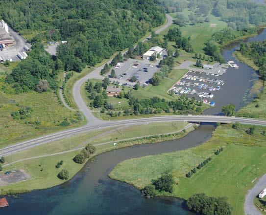
. The major land uses within Gray s Creek are residential (City of Cornwall), industrial, and agricultural.")
6 Area Land Use Soil Type Stream Flow Fishery Resources Woodlot Size Riparian Forest Rare Species Significant Natural Sites The total area of the Gray s Creek sub-watershed is 4449 ha or 44.5 km2 (2.6% of Raisin Region Watershed). The major land uses within Gray s Creek are residential (City of Cornwall), industrial, and agricultural. Despite intensive human activity, 967 ha (22%) of the sub-watershed contains vegetative cover. The sub-watershed is underlain by clay loam with poor drainage, some muck with very poor drainage, and numerous pockets of loam with good drainage. Gray s Creek and Donihee Drain flow within a flat clay plain underlain by sensitive marine deposited silty clay. Glacial till deposits have also been noted along the creek channel bottom. Erosion along Gray s Creek was more severe at creek bends, high channel banks, and in areas characterized by silty clay and glacial till. Gray s Creek is a fourth order stream system and its length is 54 km (< 20 m width), 3 km (5.6%) of which runs through public land. Warm water forage and sport fish community of 28 species, none of which are species of concern. 200 stands total in the sub-watershed, with an average size of 4.83 ha, the largest stand is 62.2 ha. Of the 3 km of streams that run through public land, 1 km (33.3 %) has a riparian buffer, only 7.8 % of the 51 km of streams on private land is buffered. Plants Brainerd s Hawthorn Provincially Significant Wetlands Summerstown Swamp Locally Significant Wetlands - None Significant Natural Areas - None Areas of Natural and Scientific Interest None 6
7 7
 938-3611 F (613)")
8 8 May 2017 Raisin Region Conservation Authority P.O. Box 429, County Road 2 Cornwall, Ontario K6H 5T2 T (613) F (613) info@rrca.on.ca
Maitland Valley WATERSHED
 Maitland Valley WATERSHED Report Card 2018 Maitland Conservation has prepared this report card as a summary of the state of your forests, wetlands, and water resources. WHERE ARE WE? We are one of 36 Conservation
WATERSHED. Maitland Valley. Report Card 201
 Maitland Valley WATERSHED Report Card 201 The Maitland Valley Conservation Authority has prepared this report card as a summary on the state of our forests, wetlands, surface water, and ground water resources.
MURPHY DRAIN CATCHMENT
 The RVCA produces individual reports for 16 catchments in the Lower Rideau subwatershed. Using data collected and analysed by the RVCA through its watershed monitoring and land cover classification programs,
Otonabee Region WATERSHED
 Otonabee Region WATERSHED Report Card 2018 Otonabee Conservation has prepared this report card as a summary of the state of your forests, wetlands, and water resources using data from 2012 to 2016. WHERE
Conservation Practices for Water Quality: Sediment & Nutrient Control. Trap Sediments/Trap Nutrients on the Field. Improve Soil Health.
 Conservation Practices for Water Quality: Sediment & Nutrient Control. Trap Sediments/Trap Nutrients on the Field. Improve Soil Health. Sediment Conservation Cover Cover Crop Critical Area Planting Field
TORCH LAKE TOWNSHIP WATER QUALITY ACTION PLAN
 TORCH LAKE TOWNSHIP WATER QUALITY ACTION PLAN Elk-River-Chain-of-Lakes Gaps Analysis Project The Watershed Center Grand Traverse Bay Tip of the Mitt Watershed Council Michigan Department of Natural Resources
Lesson 2-2: Riparian Zones
 2-14 Lesson 2-2: Riparian Zones Time of Lesson: 1 hour Rationale: The purpose of this lesson is to define what a riparian zone is and link its importance for fish and other animals, and humans, and the
VIDEO: Riparian Forest Buffers: The Link Between Land & Water
 VIDEO: Riparian Forest Buffers: The Link Between Land & Water Introduction to Riparian Buffers Adapted from: Riparian Forest Buffers: The Link Between Land & Water. Maryland Cooperative Extension. Wye
Background. AEM Tier 2 Worksheet Stream & Floodplain Management. Glossary
 AEM Tier 2 Worksheet Stream & Floodplain Management Glossary Bankfull Stage: The stage at which water starts to flow over the flood plain; the elevation of the water surface at bankfull discharge. (This
Site Condition Evaluation & Environmental Benefits Report
 Site Evaluation & Environmental Benefits Report Background The New York State Conservation Reserve Enhancement Program is a collaborative effort between the USDA and the State of New York. The goal of
VILLAGE OF BELLAIRE WATER QUALITY ACTION PLAN
 VILLAGE OF BELLAIRE WATER QUALITY ACTION PLAN Elk-River-Chain-of-Lakes Gaps Analysis Project The Watershed Center Grand Traverse Bay Tip of the Mitt Watershed Council Michigan Department of Natural Resources
Water and Watersheds. Data Maps Action
 Water and Watersheds Data Maps Action What is the Wildlife Action Plan? Restore rare wildlife and habitats. Keep common species common. 2015 Revision: Partners in Conservation Science 2015 Revision Data
Conservation Practices. Conservation Choices. These five icons will show the benefits each practice offers... 6/4/2014
 Conservation Choices Your guide to conservation and environmental farming practices. Conservation Choices These five icons will show the benefits each practice offers... The practice reduces soil erosion
Watercourses and Wetlands and Agricultural Activities
 Watercourses and Wetlands and Agricultural Activities Watercourses and regulated wetlands can be found throughout New Brunswick, including on agricultural lands. The Clean Water Act defines a watercourse
GLASI GLASI. Priority Subwatershed Project. Great Lakes Agricultural Stewardship Initiative
 GLASI GLASI Great Lakes Agricultural Stewardship Initiative Priority Subwatershed Project Wigle Creek Priority Subwatershed Project Essex Region Conservation Authority Up to $75,000 per eligible farm business
Carp Creek 2013 Summary Report
 Monitoring Activity in the Carp River Watershed In 2012, Mississippi Valley Conservation Authority (MVCA) worked with Friends of the Carp River (FCR) on a preliminary assessment of the Carp River. This
Riparian Buffers and Stream Restoration
 Riparian Buffers and Stream Restoration Why focus on riparian areas? Link land and water on any given site and link landscapes together in a watershed Riparian corridors protect the circulatory system
Agricultural/Rural Riparian Buffer Analysis
 Agricultural/Rural Riparian Buffer Analysis December 2014 Executive Summary The Agricultural/Rural Riparian Buffer Analysis was developed from a 2014 analysis of current requirements for the riparian areas
Chapter 4 Watershed Goals and Objectives
 Chapter 4 Watershed Goals and Objectives Eight (8) long-term watershed goals have been developed by the NEW Watershed Advisory Group (WAG) after consideration of discussions held during monthly watershed
WETLANDS AND WILDLIFE PONDS How to address concerns identified in your Environmental Farm Plan Worksheet #22
 INFOSHEET #22 WETLANDS AND WILDLIFE PONDS How to address concerns identified in your Environmental Farm Plan Worksheet #22 Based on Environmental Farm Plan Workbook, 4th ed. 2013 This infosheet outlines
Managing Adaptive REsponses to changing flood risk. Bergen. Haukås Watercourse HAUKUS
 Managing Adaptive REsponses to changing flood risk Bergen. Haukås Watercourse HAUKUS 130405 Developers Long term ownership Wildlife Heritage Environment Water quality Water quantity Emergency planning
Chapter 10 Natural Environment
 Chapter 10 Natural Environment Existing Conditions The Natural Environment Element addresses the protection, conservation, preservation, and restoration of the natural resources the Bayview Ridge Subarea,
Freshwater ecosystems
 Aquatic Ecosystems Aquatic Ecosystems The types of organisms in an aquatic ecosystem are determined by the water s salinity. Salinity - Amount of salt in the water. Freshwater ecosystems do not have any
SURVEY OF PUBLIC ATTITUDES ABOUT WATER ISSUES IN COLORADO
 SURVEY OF PUBLIC ATTITUDES ABOUT WATER ISSUES IN COLORADO Matt Neibauer, Reagan Waskom, and Troy Bauder Colorado State University Dept. of Soil and Crop Sciences 1 Northern Plains and Mountains Regional
Ontario Envirothon LEARNING OBJECTIVES. Ontario Envirothon Learning Objectives
 Ontario Envirothon LEARNING OBJECTIVES Updated Fall 2015 5 Contents Contents... 6 Overall Objectives... 7 Aquatic Ecology... 8 Specific Objectives... 8 Overall Objectives... 8 Application/Analysis... 9
Water Quality Conditions & Management on Rangelands
 Water Quality Conditions & Management on Rangelands Ken Tate, Leslie Roche, and Rob Atwill UC Davis and UC Cooperative Extension Grazing Workshop Mariposa County UCCE March 2014 CA Rangelands Safe Water
Pembina River Watershed Water Quality Report
 Pembina River Watershed Water Quality Report January 29 Prepared by: Manitoba Water Stewardship 16-123 Main St. Winnipeg, MB. Canada State of the Watershed Report 5OA and 5OB Pembina River Watershed -
POLICY FOR NATURAL RESOURCE MANAGEMENT AREAS
 POLICY FOR NATURAL RESOURCE MANAGEMENT AREAS I. POLICY STATEMENT Auburn University's (the University's) "Policy for Natural Resource Management Areas" implements the Campus Master Plan Land Use Element
Regional Watershed Planning. Calumet Summit 2010: A Call to Connect Calumet Conference Center April 27, 2010
 Regional Watershed Planning Calumet Summit 2010: A Call to Connect Calumet Conference Center April 27, 2010 Basins The Calumet Region Watershed Communities Land Cover- 2006 Impervious Cover 303d Listed
Big Chetac and the Red Cedar River Watershed. Dan Zerr University of Wisconsin-Extension Natural Resource Educator
 Big Chetac and the Red Cedar River Watershed Dan Zerr University of Wisconsin-Extension Natural Resource Educator The Water Cycle An area that all drains to a particular stream, river, lake, or ocean.
Saturated Buffer. Subsurface Drainage PURPOSE N REDUCTION LOCATION COST BARRIERS
 Saturated Buffer To intercept tile drainage prior to discharging to surface waters and redistribute the water laterally in the soil profile of the streamside buffer. Subsurface drainage, also known as
Chesapeake Bay s Problems
 Environmental Issues for the Chesapeake Bay Russ Perkinson Virginia State Feed Association Conference February 16, 2011 Chesapeake Bay s Problems Congressional appropriation of $27 million for six year
Reading the River 2006 Water Study Sixth Grade Science Mindy Fry Kenton County
 Reading the River 2006 Water Study Sixth Grade Science Mindy Fry Kenton County Curriculum Plan Lesson Context: To kick off this unit of study, I will have Jamie Egglemeyer from Sanitation District No.
Maintaining Riparian Areas and Wetlands
 Maintaining Riparian Areas and Wetlands Riparian areas are the lands along the banks of our rivers, lakes, and tidal waters. Many riparian areas not only border surface waters, but they are often adjacent
Funding Guidelines State Fiscal Year 2016
 State Fiscal Year 2016 Water Quality Financial Assistance Centennial Clean Water Program Clean Water Act Section 319 Program Stormwater Financial Assistance Program Washington State Water Pollution Control
Eutrophication: Tracing Nutrient Pollution Back to Penns Creek
 Eutrophication: Tracing Nutrient Pollution Back to Penns Creek Nutrients are substances that life depends on for growth and reproduction. However, when these nutrients enter our planets waterways in excess,
CITY OF SPRING HILL Water Quality Buffer Zone Policy (Adopted April 22, 2008)
") Section I - Description CITY OF SPRING HILL Water Quality Buffer Zone Policy (Adopted April 22, 2008) A water quality buffer zone (a.k.a. a riparian zone) is a strip of undisturbed native (indigenous)
Section I - Description CITY OF SPRING HILL Water Quality Buffer Zone Policy (Adopted April 22, 2008) A water quality buffer zone (a.k.a. a riparian zone) is a strip of undisturbed native (indigenous)
Hydrology and Water Quality. Water. Water 9/13/2016. Molecular Water a great solvent. Molecular Water
 Hydrology and Water Quality Water Molecular Water Exists as an equilibrium But equilibrium altered by what is dissolved in it Water Molecular Water a great solvent In reality, water in the environment
HOW CHANGES IN NUTRIENT MANAGEMENT REGULATIONS WILL AFFECT FORAGE PRODUCTION
 HOW CHANGES IN NUTRIENT MANAGEMENT REGULATIONS WILL AFFECT FORAGE PRODUCTION Dick Wolkowski and Larry Bundy Department of Soil Science University of Wisconsin What are the issues Forage producers typically
VEGETATIVE, WATER, FISH AND WILDLIFE RESOURCES POLICIES
 VEGETATIVE, WATER, FISH AND WILDLIFE RESOURCES POLICIES The County will: GOALS AND OBJECTIVES 1.1 Conserve, Enhance, Protect, Maintain and Manage Vegetative, Water, Fish and Wildlife Resources Promote
Sustainable Natural Environment Fish Habitat
 Town of Huntsville Official Plan Review - POLICY BACKGROUND PAPER Sustainable Natural Environment Fish Habitat BACKGROUND: Lakes, rivers, streams, ponds and many wetlands provide fish habitat. Intermittent
PROTECTING OUR WATERWAYS: STORMWATER POLLUTION REDUCTION EFFORTS
 PROTECTING OUR WATERWAYS: STORMWATER POLLUTION REDUCTION EFFORTS Public Information Meeting ~ May 2, 2018 Public Works Stormwater Management Division OVERVIEW Surface Water Quality Protection Municipal
Natural and Engineered Wetlands for Stormwater Management
 Natural and Engineered Wetlands for Stormwater Management Dan Hitchcock, Ph.D., P. E. Baruch Institute of Coastal Ecology and Forest Science Clemson University Georgetown, SC Prominence and Diversity of
SITE ALTERATION PERMIT INFORMATION PACKAGE FOR LAND OWNERS
 SITE ALTERATION PERMIT INFORMATION PACKAGE FOR LAND OWNERS Revised: June 4, 2014 Requirements for obtaining a site alteration permit vary depending on the type of project being proposed. This information
Conservation District Business Plan Steuben County Soil and Water Conservation District
 Conservation District Business Plan Steuben County Soil and Water Conservation District I find the great thing in this world is not so much where we stand as in what direction we are moving Oliver Wendell
OUR MISSION: To preserve, protect, and restore Delaware s Inland Bays the water that flows into them and the watershed around them.
 OUR MISSION: To preserve, protect, and restore Delaware s Inland Bays the water that flows into them and the watershed around them. OUR In 1988, the Delaware Inland Bays were declared an estuary of national
What Does It All Mean? CWA? Sara Esposito, P.E. DNREC Division of Watershed Stewardship
 What Does It All Mean? CWA? Sara Esposito, P.E. DNREC Division of Watershed Stewardship sara.esposito@state.de.us Why are we here? Just like pavement has helped move cars faster; it has also helped water
What factors affect life in aquatic ecosystems?
 Aquatic Ecosystems: Notes Outline Today s Objective: Students will explain that different types of organisms exist within aquatic systems due to chemistry, geography, light, depth, salinity, and/or temperature.
BIG ROCHE A CRI LAKE CHARACTERISTICS
 BIG ROCHE A CRI LAKE CHARACTERISTICS Lake Description Big Roche Cri Lake is located in north central Adams County and has a surface area of 205 acres, a shoreline length of 6.1 mile, a volume of 6,993
Watts Creek 2014 Summary Report
 Monitoring Activity in the City of Ottawa In 2012, Mississippi Valley Conservation Authority (MVCA) and the Friends of the Carp River (FCR) collaborated to undertake a broad scale assessment of potential
Wetland Monitoring. City of Edmonton. Edmonton Wetlands Workshop December 4-5, 2013
 Wetland Monitoring City of Edmonton Edmonton Wetlands Workshop December 4-5, 2013 City of Edmonton Presentation Outline Kennedale Wetland Water Quality Sediment removal Vegetation management Biological
Riparian Buffer Requirements. Department of Environmental Protection Bureau of Watershed Management
 102.14 - Riparian Buffer Requirements Department of Environmental Protection Bureau of Watershed Management 102.2 Scope and Purpose BMPs to protect, maintain, and restore water quality and existing designated
Chapter 6. Aquatic Biodiversity. Chapter Overview Questions
 Chapter 6 Aquatic Biodiversity Chapter Overview Questions Ø What are the basic types of aquatic life zones and what factors influence the kinds of life they contain? Ø What are the major types of saltwater
 Good Morning! Bruce Gilman Department of Environmental Conservation and Horticulture Finger Lakes Community College 3325 Marvin Sands Drive Canandaigua, New York 14424 585-785- 1255 gilmanba@flcc.edu Northern
Soil Degradation. Lesson Plan NRES B2-9
 Soil Degradation Lesson Plan NRES B2-9 Objectives 1. What is soil degradation? 2. How can construction result in soil degradation? 3. What are the sources of contamination, and how do they result in soil
WHATCOM COUNTY STANDARD FARM CONSERVATION PLAN PLANNING WORKBOOK: Checklist and Action Plan
 WHATCOM COUNTY STANDARD FARM CONSERVATION PLAN PLANNING WORKBOOK: Checklist and Action Plan For use with the publication: Tips on Land and Water Management For: Land Owner Address Date Introduction Conservation
FieldDoc.org User Guide For 2017 NFWF Chesapeake Bay Stewardship Fund Applicants. Background 2. Step 1: Register for a FieldDoc account 3
 FieldDoc.org User Guide For 2017 NFWF Chesapeake Bay Stewardship Fund Applicants Table of Contents (click to go to page) Background 2 Step 1: Register for a FieldDoc account 3 Step 2: Create the Project
Streamlines V2, n2 (May 1997) A Newsletter for North Carolina Water Supply Watershed Administrators
 A Newsletter for North Carolina Water Supply Watershed Administrators") Page 1 of 5 STREAMLINES A Newsletter for North Carolina Water Supply Watershed Administrators Volume 2, Number 2 May 1997 Non-Point Source (NPS) Pollution This issue of Streamlines provides basic information
Page 1 of 5 STREAMLINES A Newsletter for North Carolina Water Supply Watershed Administrators Volume 2, Number 2 May 1997 Non-Point Source (NPS) Pollution This issue of Streamlines provides basic information
Municipal Class Environmental Assessment for Pottersburg Creek Slope Stability Study South of Hamilton Road, Schedule B
 Municipal Class Environmental Assessment for Pottersburg Creek Slope Stability Study South of Hamilton Road, Schedule B February 13, 2013 Municipal Class EA Process We are here Purpose and Objective of
FACTSHEET INTRODUCTION. help rebalance the water cycle, mitigate the effects of climate change and improve human health and livelihoods.
 1 FACTSHEET INTRODUCTION World Water Day, on 22 March every year, is about focusing attention on the importance of water. This year s theme, Nature for Water, explores nature-based solutions (NBS) to the
4-4 Aquatic Ecosystems
 biology 1 of 39 2 of 39 Nearly three-fourths of the Earth s surface is covered with water. Almost all bodies of water contain a wide variety of communities governed by biotic and abiotic factors including
The Social and Economic Importance of Canada s Privately Owned Forest Lands
 The Social and Economic Importance of Canada s Privately Owned Forest Lands Key Points n Private forests make up 6% of Canada s 402 million ha of forested land and 13% of the managed forest. n Private
Rags to Riches - The RVCA Story of Science to Stewardship. Subwatershed Reporting
 Rags to Riches - The RVCA Story of Science to Stewardship Subwatershed Reporting Monitor Act and Engage Analyze Report Subwatershed Reporting Overview Content of reports Users Monitor Act and Engage Analyze
Waterways Local Update
 Waterways Local Update 2016-17 Melbourne Water s work to improve waterways and provide flood protection in the City of Banyule. REDUCED THE RISK OF FLOODING 29.7 km WEED CONTROL ALONG WATERWAYS THREE ENVIRONMENTAL
Riffle Beetles to Riparian Buffers
 We care about WateR. it S What We do. Riffle Beetles to Riparian Buffers Exploring Methods of Assessing Surface Water Quality Grade level: 7-12 objective: Students will evaluate the quality of two water
Nutrient Management in. A presentation to the West Metro Water Alliance
 Nutrient Management in Developing and Agricultural Areas A presentation to the West Metro Water Alliance Chris Meehan, P.E. May 25, 2011 Agenda Physical Improvements Planning Improvements How to get it
ECOSYSTEMS, WATERSHEDS AND POLLUTION CONTROL REVIEW
 ECOSYSTEMS, WATERSHEDS AND POLLUTION CONTROL REVIEW ECOSYSTEMS: (6 th grade content) How biotic and abiotic factors make an ecosystem: https://www.youtube.com/watch?v=mdlwptkg-vi 1. A/An ecosystem is a
The Hypoxic Zone in the Gulf of Mexico
 The Hypoxic Zone in the Gulf of Mexico References Council Committee on Environmental and Natural Resources. 2003. An Assessment of Coastal Hypoxia and Eutrophication in U.S. Water. National Science and
AP Environmental Science
 AP Environmental Science Types of aquatic life zones MARINE Estuaries coral reefs mangrove swamps neritic zone pelagic zone FRESHWATER lakes and ponds streams and rivers wetlands Distribution of aquatic
Mississippi River Basin Healthy Watershed Initiative
 Mississippi River Basin Healthy Watershed Initiative A Progress Report for Arkansas Presented by: Mike Sullivan, State Conservationist FY 2010 12 States 41 Focus Areas FY 2011 Added two focus areas: SD/MS
Welcome. Thank you for joining us! Lower Mississippi River Watershed Management Organization
 Welcome. Thank you for joining us! Lower Mississippi River Watershed Management Organization Lower Mississippi River Watershed Management Organization Watershed Restoration and Protection (WRAP) Study
Narragansett Bay and Watershed Restoration Bond Fund
 Narragansett Bay and Watershed Restoration Bond Fund 1) Govt. Entities Nonpoint Source Water Pollution Control Fund 2) Non-Govt. Non-point Source Water Pollution Control Fund 3) Riparian Buffer Restoration
STREAM AND BUFFER AREA PROTECTION/RESTORATION
 STREAM AND BUFFER AREA PROTECTION/RESTORATION AMENDMENT OPTIONS TO STRENGTHEN POLICY IN HEADWATERS AREAS DRAFT SUBSEQUENT TO THE JANUARY 25, 2007 MEETING OF THE PLANNING COMMISSION ENVIRONMENT COMMITTEE
RIPARIAN FOREST BUFFER
 RIPARIAN FOREST BUFFER (Acres) Code 391 Natural Resources Conservation Service Conservation Practice Standard I. Definition An area predominantly of trees and shrubs that functions as a vegetated ecotone
Grants Pass Water Quality Monitoring
 Grants Pass Water Quality Monitoring 2003-2005 Rogue Valley Council of Governments April 2005 Rogue Valley Council of Governments Natural Resources Department 155 North First Street Central Point, Oregon
3 Objectives 3 Ob jec tives
 3 Objectives 3 Objectives 3 Objectives 3 Objectives contents Objective number Page 3.1 Ki uta ki tai: mountains to the sea O1-O5 37 3.2 Beneficial use and development O6-O13 38 3.3 Māori relationships
DAKOTA COUNTY SOIL AND WATER CONSERVATION DISTRICT COMPREHENSIVE PLAN
 DAKOTA COUNTY SOIL AND WATER CONSERVATION DISTRICT COMPREHENSIVE PLAN 2011-2015 4100 220 th Street West, Suite 102 Farmington, MN 55024 651-480-7777 www.dakotacountyswcd.org I. INTRODUCTION A. Purpose
The Colley Bay Story: Successful Implementation of a Living Shoreline
 The Colley Bay Story: Successful Implementation of a Living Shoreline Definition Living Shoreline Treatments address erosion in lower energy situations by providing long-term protection, restoration or
DFO s Fish Habitat Management Program
 DFO s Fish Habitat Management Program Overview Fish and Fish Habitat DFO Policy - Objectives and Goals How Do the Fisheries Act and Navigable Waters Protection Act Affect Cattle Producers Riparian Areas,
Natural Systems Planning Primer
 Natural Systems Planning Primer Lise.Guevremont@ottawa.ca Amy.Macpherson@ottawa.ca Land Use and Natural Systems Unit Planning and Growth Management November 2015 1 Welcome Policy Framework Development
Riverfront Property. Land use related water pollution. Creek Connections Water Pollution Module Riverfront Property. Grade Level: Basic
 Riverfront Property Land use related water pollution Adapted from: Reaching Your Limits in Project WET: Curriculum & Activity Guide. Bozeman: The Watercourse and the Council for Environmental Education,
Hamilton Harbour. Area of Concern Status of Beneficial Use Impairments September 2010
 Hamilton Harbour Area of Concern Status of Beneficial Use Impairments September 2010 Hamilton Harbour is a 2150-ha bay located at the western tip of Lake Ontario. The Area of Concern covers about 500 km
Riparian Buffer Restoration Fund. Gregg J. Cassidy RI DEM, Sustainable Watersheds Office
 Riparian Buffer Restoration Fund Gregg J. Cassidy RI DEM, Sustainable Watersheds Office Narragansett Bay and Watershed Restoration Bond Fund 1) Govt. Entities Nonpoint Source Water Pollution Control Fund
Name That Source. Point and Nonpoint Sources
 Name That Source Point and Nonpoint Sources Adapted from: Name That Source in Environmental Resource Guide: Nonpoint Source Pollution Prevention. Air & Waste Management Association, 1992. Grade Level:
West Fork White River Watershed Conservation Map Summaries. Prepared for the Beaver Watershed Alliance. By the Watershed Conservation Resource Center
 West Fork White River Watershed Conservation Map Summaries Prepared for the Beaver Watershed Alliance By the Watershed Conservation Resource Center November 2014 The Watershed Conservation Resource Center
BIOMES. Living World
 BIOMES Living World Biomes Biomes are large regions of the world with distinctive climate, wildlife and vegetation. They are divided by terrestrial (land) or aquatic biomes. Terrestrial Biomes Terrestrial
Environment GOALS OVERVIEW
 Environment 10 GOALS 10 (A) Victoria s urban forests and public and private green spaces support healthy and diverse ecosystems. 10 (B) Victoria s Harbour, coastline, ponds and streams support healthy
STREAM RESTORATION PURPOSE, PRACTICE, AND METHODS. By Marcus Rubenstein, CPESC
 STREAM RESTORATION PURPOSE, PRACTICE, AND METHODS By Marcus Rubenstein, CPESC WHAT IS STREAM RESTORATION? The return of a stream s lost natural functions, usually resulting from watershed alterations,
Nutrients and Water Quality in the East Souris River Watershed
 Nutrients and Water Quality in the East Souris River Watershed Phosphorus and nitrogen occur naturally and are important plant nutrient sources in water bodies. However, several human factors have created
TERMS OF REFERENCE SOUTHWEST INTERLAKE INTEGRATED WATERSHED MANAGEMENT PLAN
 TERMS OF REFERENCE SOUTHWEST INTERLAKE INTEGRATED WATERSHED MANAGEMENT PLAN March 17, 2014 TABLE OF CONTENTS 1.0 INTRODUCTION Page 1 PURPOSE PLANNING PROCESS PRINCIPLES OF INTEGRATED WATERSHED MANAGEMENT
Hickory Creek 319 grant project City of Denton
 Hickory Creek 319 grant project City of Denton Kenneth Banks, Division of Environmental Quality, City of Denton PREPARED IN COOPERATION WITH THE TEXAS COMMISSION ON ENVIRONMENTAL QUALITY AND U.S. ENVIRONMENTAL
Introduction. Wetland System. A Wetland Scene at Lorne C. Henderson Conservation Area near Petrolia
 Wetland Treatment of Wastewater This monograph, one in a series of single issue documents that deal with our local environment, has been prepared by the Sarnia-Lambton Environmental Association in co-operation
Strategic Plan. Grand River Conservation Authority
 Grand River Conservation Authority Strategic Plan The Grand River Conservation Authority is a partnership of 39 municipalities created to manage water and natural resources for the benefit of the 960,000
30 Years of River Quality
 30 Years of River Quality A Retrospective and Prospective View EPA National Water Event Galway Bay Hotel 12-13 June 2013 John Lucey Presentation Outline Overview of past 30 years river quality Problems
CARBON FARMING IN MARIN
 CARBON FARMING IN MARIN MARIN CAP SUBCOMMITTEE AUGUST 21, 2017 Can we increase soil carbon? Can we measure it? Compost Results: Carbon Organic matter amendments increased soil carbon by 50 MT C ha -1 in
Ecological Services: Valuing Natural Areas within CLOCA
 Ecological Services: Valuing Natural Areas within CLOCA Action Plan #14 October 2017 CONTENTS 1. INTRODUCTION... 4 1.1 Purpose... 4 1.2 Context... 4 2. DISCUSSION... 5 2.1 What Are Ecological Goods and
ROUNDTABLE MEETING ON SUSTAINABLE PALM OIL. RSPO Guidance for the Management and rehabilitation of Riparian Reserves Holly Barclay
 ROUNDTABLE MEETING ON SUSTAINABLE PALM OIL RSPO Guidance for the Management and rehabilitation of Riparian Reserves Holly Barclay Riparian reserves (also called riparian buffer zones ) = strips of natural
C O M P R E H E N S I V E P R O T E C T I O N & R E S T O R AT I O N P L A N. f or th e
 C O M P R E H E N S I V E P R O T E C T I O N & R E S T O R AT I O N P L A N f or th e R O S S B A R NE T T R E SERV O I R WATERS HED, MI S S I S S I P P I E X E C U T I V E S U M M A R Y O C T O B E R
Think About It (not on notes)
") Aquatic Ecosystems Think About It (not on notes) We call our planet Earth, yet nearly three-fourths of Earth s surface is covered with water. Despite the vital roles aquatic ecosystems play in the biosphere,
Aquatic Ecosystems Think About It (not on notes) We call our planet Earth, yet nearly three-fourths of Earth s surface is covered with water. Despite the vital roles aquatic ecosystems play in the biosphere,