Detection of Deforestation in China and South East Asia using GF-1 time-series Data
|
|
|
- Leo McBride
- 5 years ago
- Views:
Transcription

1 Detection of Deforestation in China and South East Asia using GF-1 time-series Data Project No Dr. Tan Bingxiang, Institute of Forest Resources Information Technique, CAF, Beijing, China Mike Wooding, Remote Sensing Applications Consultants, UK
2 Background FAO Report: < < Global remote sensing survey 2010 update >> The survey shows the total forest area in 2010 was 3.89 billion hectares, which is around 30 percent of the global land area. Over half the world s forests(53%) are in tropical or subtropical climatic domains. Between 1990 and 2010, there was a net reduction in the global forest area of around 5.3 million ha/year. The gross reduction in forest land use over the 20year time period (15.5 million hectares per year) was partially offset by gains in forest area through afforestation and natural forest expansion (10.2 million hectares per year).
3

4 Forest Cover Change in one District of LAOs
5 So, it is very important to develop techniques for closely monitoring areas of interest (e.g. deforestation) using remote sensing data(sar or optical satellite data )to quickly detect changes within forested areas, both logging and fire damage. And produce detailed and timely forest change maps. For the monitoring of timely forest change, it needs time-series satellite data. At the moment, Sentinel 1 SAR data and GF-1 data are the better choice. This presentation will focus on the use of GF-1 data
6 GF-1 satellite Data The Chinese GF-1 satellite is a new high spatial resolution satellite launched on April 26, It was equipped with two types of sensors. One is the wide field view sensor (WFV sensor); the other is the panchromatic and multispectral sensor (PMS sensor). The WFV sensor can acquire multispectral image in blue, green, red, and nearinfrared bands with 16 meters spatial resolution and 4 days temporal resolution. The PMS sensor can acquire a panchromatic and multispectral image with 41 days temporal resolution. The spatial resolution of a panchromatic image acquired by the PMS sensor is 2 meters, while the spatial resolution of a multispectral image acquired by the PMS sensor in blue, green, red, and nearinfrared bands is 8 meters.
7 The characteristics of the GF-1 satellite 2m panchromatic & 8m multispectral sensor Panchromatic sensor μm 16m WFV sensor Wavelength (um) multispectral sensor μm μm μm μm μm μm μm μm Spatial resolution (meters) Wide swath Panchromatic sensor 2m multispectral sensor 8m 60km(2cameras combination) 16m 800km ( 4cameras combination) Revisit time 41days 4days
8 Study Objectives GF-1 satellite wide field of view ( WFV) sensor data were used with the purpose of evaluating the GF - 1 satellite s application capability in forest change monitoring and developing methods of mapping change.


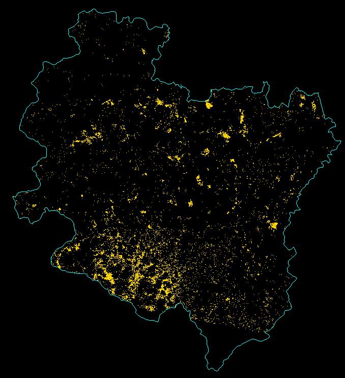
9 Test Site and Data Processing Located in Ningming county of Guangxi Province, China. Total area of Ningming is 3698km 2, forest coverage rate reaches 30%.

10 4 dates GF-1 data were acquired for the test site and geometrically corrected
11 Two dates of GF-1 data were selected with the purpose of forest change monitoring (1 year apart) R4:G3:B R4:G3:B2
12 Deforestation detection flow chart Satellite Image data GF-1 first time image GF-1 second time image Images preprocessing Optimum band selection Supervised classification Post classification procession Accuracy assessment Deforestation mapping

13 Composite image R: B3 G: B3 B: B2 Deforestion area

 Composite Image 20140514")
14 ptimum bands selection Deforestation between Image of (R:4,G:3,B:2) Image of (R:4,G:3,B:2) Composite Image and

 Composite Image of 20140514")
15 Feature bands selection Deforestation between Image of (R:4,G:3,B:2) Image of (R:4,G:3,B:2) Composite Image of and

16 Using the composite image to classify the deforestation area with a supervised classification approach.
17 Classification and results --The deforestation area was classified as a single class using a supervised classification approach; --After post-classification processing, the deforestation map was created.
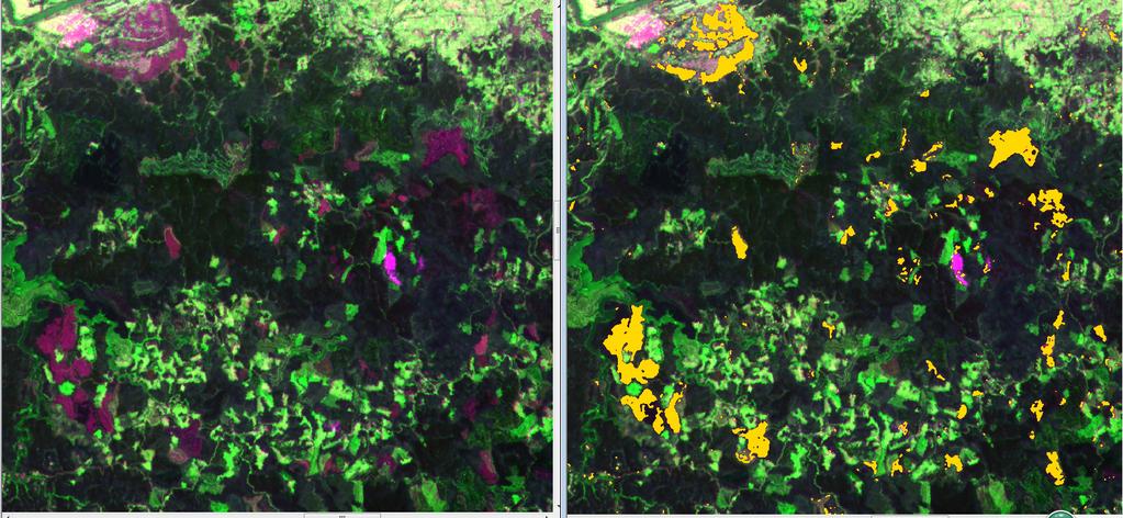
18 Deforestation map between to
19 Summary and future plan Summary 1. The temporal resolution of GF-1 WFV sensor is 4 days, so it is possible to obtain good quality optical images every year in the subtropical and tropical area. 2. Deforestation areas in GF-1 imagery are very clear and easy to identify. GF-1 imagery is suitable for the detection of forest change over extremely large areas because of the 800km swath coverage. 3. The use of just 3 bands from the 2 date images enabled easy identification and classification of deforested areas. 4. New areas of deforestation are able to be tracked every year across the whole of sub-tropical China using just two cloud free images each year.
20 Future plan 1. Mapped areas of deforestation need to be properly validated using ground data. 2. The method developed in our study needs to be demonstrated for mapping over large areas. 3. Forest change includes forest loss and forest gain. So far we have focused on deforestation, but future work needs to include mapping of new plantings and regenerated areas. 4. The application potential of Sentinel-2 is similar to GF1 as it will provide the same frequent repeat wide swath data.

21 Thanks you for your attention!
GLOBAL FOREST LAND- USE CHANGE FROM 1990 TO 2010: AN UPDATE TO A GLOBAL REMOTE SENSING SURVEY OF FORESTS
 Forest Resources Assessment Working Paper 187 GLOBAL FOREST LAND- USE CHANGE FROM 1990 TO 2010: AN UPDATE TO A GLOBAL REMOTE SENSING SURVEY OF FORESTS The designations employed and the presentation of
Opportunities and challenges for monitoring tropical deforestation and forest degradation in dynamic landscapes using Sentinel-2!
 Sentinel-2 For Science Workshop 20-22 May, 2014 ESA-ESRIN Frascati Opportunities and challenges for monitoring tropical deforestation and forest degradation in dynamic landscapes using Sentinel-2 Dirk
Role of Remote Sensing in Flood Management
 Role of Remote Sensing in Flood Management Presented by: Victor Veiga (M.Sc Candidate) Supervisors: Dr. Quazi Hassan 1, and Dr. Jianxun He 2 1 Department of Geomatics Engineering, University of Calgary
Earth Observation for Sustainable Development of Forests (EOSD) - A National Project
 - A National Project") Earth Observation for Sustainable Development of Forests (EOSD) - A National Project D. G. Goodenough 1,5, A. S. Bhogal 1, A. Dyk 1, R. Fournier 2, R. J. Hall 3, J. Iisaka 1, D. Leckie 1, J. E. Luther
Earth Observation for Sustainable Development of Forests (EOSD) - A National Project D. G. Goodenough 1,5, A. S. Bhogal 1, A. Dyk 1, R. Fournier 2, R. J. Hall 3, J. Iisaka 1, D. Leckie 1, J. E. Luther
Tropical forest degradation monitoring using ETM+ and MODIS remote sensing data in the Peninsular Malaysia
 IOP Conference Series: Earth and Environmental Science OPEN ACCESS Tropical forest degradation monitoring using ETM+ and MODIS remote sensing data in the Peninsular Malaysia To cite this article: M Hashim
2014REDD302_41_JCM_PM_ver01
 Joint Crediting Mechanism Proposed Methodology Form Cover sheet of the Proposed Methodology Form Form for submitting the proposed methodology Host Country Indonesia Name of the methodology proponents Mitsubishi
Object-oriented Classification and Sampling Rate of Landsat TM Data for Forest Cover Assessment. Yasumasa Hirata 1, Tomoaki Takahashi 1
 Object-oriented Classification and Sampling Rate of Landsat TM Data for Forest Cover Assessment Yasumasa Hirata 1, Tomoaki Takahashi 1 1 Forest Management Department, Forestry and Forest Products Research
Role and importance of Satellite data in the implementation of the COMIFAC Convergence Plan
 Plenary Meeting of the Congo Basin Forest Partnership (CBFP) Palais des Congrès, Yaoundé. Cameroon 11-12 November, 2009 Role and importance of Satellite data in the implementation of the COMIFAC Convergence
Future remote sensors for chlorophyll a. Dimitry Van der Zande, Quinten Vanhellemont & Kevin Ruddick
 Future remote sensors for chlorophyll a Dimitry Van der Zande, Quinten Vanhellemont & Kevin Ruddick Workshop Scheldt Commission: eutrophication 20 th October 2016 Ocean colour from space ESA MERIS 7 May
Cropland Mapping with Satellite Data
 Cropland Mapping with Satellite Data Rick Mueller Head/Spatial Analysis Research USDA/National Agricultural Statistics Service Border-Area Water Management Remote Sensing Workshop Agenda Cropland Data
The role of remote sensing in global forest assessments. Introduction, objectives and alternative survey scenarios
 The role of remote sensing in global forest assessments Erkki Tomppo 1 and Ray Czaplewski 2 1 Finnish Forest Research Institute, National Forest Inventory Unioninkatu 40 A, FIN-00170 Helsinki, Finland
A Report on the City of Lexington s Existing and Possible Urban Tree Canopy
 A Report on the City of Lexington s Existing and Possible Urban Tree Canopy Project Background Key Terms The analysis of Lexington s urban tree canopy (UTC) was carried out at the request of the Virginia
The NISAR Mission. Paul Siqueira Emerging Technologies and Methods in Earth Observation for Agriculture Monitoring College Park, 2018
 The NISAR Mission Paul Siqueira Emerging Technologies and Methods in Earth Observation for Agriculture Monitoring College Park, 2018 Flyer A one-page paper-flyer is available with more information NISAR
Assessing Forest Degradation using Time Series of Fine Spatial Resolution Imagery in Africa
 Assessing Forest Degradation using Time Series of Fine Spatial Resolution Imagery in Africa A. Verhegghen, B. Desclée, H. Eva, P. Mayaux, F. Achard European Commission Joint Research Centre Sentinel-2
Crop Growth Monitor System with Coupling of AVHRR and VGT Data 1
 Crop Growth Monitor System with Coupling of AVHRR and VGT Data 1 Wu Bingfng and Liu Chenglin Remote Sensing for Agriculture and Environment Institute of Remote Sensing Application P.O. Box 9718, Beijing
Basic Concept of Early Warning System for Tropical Forest
 System for Monitoring of Tropical Forest Japan Pavilion, December 1, (13:00-14:00) Basic Concept of Early Warning System for Tropical Forest - Initiative for Improvement of Forest Governance by JICA/JAXA
RESULTS & RECOMMENDATIONS from. The Dragon Forest Projects
 RESULTS & RECOMMENDATIONS from The Dragon Forest Projects Forest Fire Id. 10350 Forest Change Monitoring Id. 10549 PolInSAR Id. 10609 The Forest Dragon 3 Id. 10666 Forest Resources Research Id. 10667 Forest
Beijing-1 1 Small Satellite System & Its Application. Beijing Landview Mapping Information Technology Co. Ltd. (BLMIT) 10 February 2011
 10 February 2011") Beijing-1 1 Small Satellite System & Its Application Beijing Landview Mapping Information Technology Co. Ltd. (BLMIT) 10 February 2011 Contents Beijing-1 1 System Application Research International Communication
Beijing-1 1 Small Satellite System & Its Application Beijing Landview Mapping Information Technology Co. Ltd. (BLMIT) 10 February 2011 Contents Beijing-1 1 System Application Research International Communication
Generating Data from National Forest Monitoring
 Generating Data from National Forest Monitoring and Click Carbon to edit Accounting (REDD Master MRV) title style Alexander Lotsch Click to edit Master subtitle style World Bank Forest Carbon Partnership
Forest and land cover change detection is one of the major applications of satellite-based remote
 4.3 Trend, Nature and Rate of Forest Cover Change 4.3.1 Extent of Ikhoho Forest Cover in the year 2000 and to 2010 Forest and land cover change detection is one of the major applications of satellite-based
MONITORING LAND USE AND LAND USE CHANGES IN FRENCH GUIANA BY OPTICAL REMOTE SENSING
 MONITORING LAND USE AND LAND USE CHANGES IN FRENCH GUIANA BY OPTICAL REMOTE SENSING Photo : Valéry Gond Photo : Valéry Gond Photo Photo : Gaëlle : : Valéry VERGER Gond Gaëlle VERGER ONF, French National
Monitoring Natural Sal Forest Cover in Modhupur, Bangladesh using Temporal Landsat Imagery during
 Monitoring Natural Sal Forest Cover in Modhupur, Bangladesh using Temporal Landsat Imagery during 1972 2015 Hasan Muhammad Abdullah *, M. Golam Mahboob, Md.Mezanur Rahman, Tofayel Ahmed * Assistant Professor,
Identification of Crop Areas Using SPOT 5 Data
 Identification of Crop Areas Using SPOT 5 Data Cankut ORMECI 1,2, Ugur ALGANCI 2, Elif SERTEL 1,2 1 Istanbul Technical University, Geomatics Engineering Department, Maslak, Istanbul, Turkey, 34469 2 Istanbul
An Evaluation of Quickbird Data for Assessing Woodland Resource in Deciduous Sal Forests in Bangladesh. Sheikh Tawhidul Islam
 An Evaluation of Quickbird Data for Assessing Woodland Resource in Deciduous Sal Forests in Bangladesh. Sheikh Tawhidul Islam Supervisors: Dr. Danny Donoghue and Dr. Peter Atkins Overview of the presentation
Monitoring forest & tree cover in Africa with Japanese satellite. JAXA Presented by Manabu Watanabe (Tokyo Denki University)
") Monitoring forest & tree cover in Africa with Japanese satellite. JAXA Presented by Manabu Watanabe (Tokyo Denki University) Contents 1. Japanese satellites 2. Forest/Non-Forest Map 3. JICA-JAXA Forest
Monitoring forest & tree cover in Africa with Japanese satellite. JAXA Presented by Manabu Watanabe (Tokyo Denki University) Contents 1. Japanese satellites 2. Forest/Non-Forest Map 3. JICA-JAXA Forest
JECAM Synthetic Aperture Radar (SAR) Cross Site Experiments. JECAM Meeting, October 2016, Ukraine
 Cross Site Experiments. JECAM Meeting, October 2016, Ukraine") JECAM Synthetic Aperture Radar (SAR) Cross Site Experiments JECAM Meeting, October 2016, Ukraine Recent (2016) Developments Preliminary roadmap for the JECAM SAR cross sites experiments presented at 2015
JECAM Synthetic Aperture Radar (SAR) Cross Site Experiments JECAM Meeting, October 2016, Ukraine Recent (2016) Developments Preliminary roadmap for the JECAM SAR cross sites experiments presented at 2015
Remote sensing systems to monitor conversion areas
 Supported by Remote sensing systems to monitor conversion areas Lao-EU FLEGT VPA, Crowne Plaza, Seite 1 Supported by Contents 1 Monitoring of Conversion Areas 2 Optical Earth Observation 3 Forest Degradation
multi-temporal FORMOSAT-2 images Mapping paddy rice agriculture using Kang-Tsung Chang Shou-Hao Chiang Tzu-How Chu Yi-Shiang Shiu
 Mapping paddy rice agriculture using multi-temporal FORMOSAT-2 images Yi-Shiang Shiu Shou-Hao Chiang Tzu-How Chu Kang-Tsung Chang Department of Geography, National Taiwan University Outline Introduction
European Forest Fire Information System (EFFIS) - Rapid Damage Assessment: Appraisal of burnt area maps with MODIS data
 - Rapid Damage Assessment: Appraisal of burnt area maps with MODIS data") European Forest Fire Information System (EFFIS) - Rapid Damage Assessment: Appraisal of burnt area maps with MODIS data Paulo Barbosa European Commission, Joint Research Centre, Institute for Environment
European Forest Fire Information System (EFFIS) - Rapid Damage Assessment: Appraisal of burnt area maps with MODIS data Paulo Barbosa European Commission, Joint Research Centre, Institute for Environment
Expert Meeting on Crop Monitoring for Improved Food Security, 17 February 2014, Vientiane, Lao PDR. By: Scientific Context
 Satellite Based Crop Monitoring & Estimation System for Food Security Application in Bangladesh Expert Meeting on Crop Monitoring for Improved Food Security, 17 February 2014, Vientiane, Lao PDR By: Bangladesh
I. SOIL MOISTURE, CROP AND VEGETATION STUDY USING AIRSAR DATA
 I. SOIL MOISTURE, CROP AND VEGETATION STUDY USING AIRSAR DATA Dr. Flaviana Hilario (1) and Dr. Juliet Mangera (2) (1) PAGASA (Weather Bureau), ATB 1424 Quezon Ave, Quezon City, Philippines, 1100, Philippines
Annual Deforestation Mapping in Sumatera using multi temporal digital classification
 Annual Deforestation Mapping in Sumatera 1990-2014 using multi temporal digital classification Kustiyo Remote Sensing Technology and Data Center LAPAN International Workshop on Land Use/Cover Change and
Status & issues of the World Forests
 Status & issues of the World Forests MCT course of IFS officers -Phase IV Indira Gandhi National Forest Academy, Dehradun 26 June 2013 Dr Devendra PANDEY Fmr DG, Forest Survey of India Fmr PCCF and Prl
REGIONAL WORKSHOP ON REDD+ MRV IMPLEMENTATION AND DRIVERS OF DEFORESTATION
 REGIONAL WORKSHOP ON REDD+ MRV IMPLEMENTATION AND DRIVERS OF DEFORESTATION Guyana Forestry Commission Guyana, South America December, 2013 Outline of Presentation Background to MRV System Development Developing
Challenges for MRV in agroforestry systems using remote sensing techniques Hans Fuchs
 Challenges for MRV in agroforestry systems using remote sensing techniques Hans Fuchs DAAD Workshop Dubai and Doha 27.11 2.12.2012 Contents Agroforestry and REDD+ Classification of agroforestry systems
REDD+ for the Guiana Shield. Terms of Reference SAR Technical Training for Forest Mapping
 REDD+ for the Guiana Shield Technical and Regional Platform for the Development of REDD+ in the Guiana Shield Terms of Reference SAR Technical Training for Forest Mapping Project Owner: Office National
REDDAF. Infosheet. Content. Objective and Concept. November 2012
 November 2012 REDDAF Infosheet Content Objective and Concept Objective and Concept 1 User Requirements 2 Methods Development 2 Service Development 5 Validation and Proof of Concept 6 Capacity Building/Training
Detecting deforestation with multitemporal L-band SAR imagery: a case study in western Brazilian Amazônia
 INT. J. REMOTE SENSING INPE eprint: sid.inpe.br/eprint@80/2006/12.08.13.17 v1 2006-12-09 2006, 1 8, PrEview article Detecting deforestation with multitemporal L-band SAR imagery: a case study in western
Crop mapping with satellite data
 Crop mapping with satellite data Dr. C.S. Murthy Head, Agricultural Sciences and Applications National Remote Sensing Centre, Hyderabad murthy_cs@nrsc.gov.in, csmurthy09@gmail.com Geospatial Technology
Improvements in Landsat Pathfinder Methods for Monitoring Tropical Deforestation and Their Extension to Extra-tropical Areas
 Improvements in Landsat Pathfinder Methods for Monitoring Tropical Deforestation and Their Extension to Extra-tropical Areas PI: John R. G. Townshend Department of Geography (and Institute for Advanced
A Remote Sensing Based System for Monitoring Reclamation in Well and Mine Sites
 A Remote Sensing Based System for Monitoring Reclamation in Well and Mine Sites Nadia Rochdi (1), J. Zhang (1), K. Staenz (1), X. Yang (1), B. James (1), D. Rolfson (1), S. Patterson (2), and B. Purdy
Monitoring Forest Change with Remote Sensing
 Monitoring Forest Change with Remote Sensing Curtis Woodcock (curtis@bu.edu) Suchi Gopal Scott Macomber Mary Pax Lenney Boston University (Dept of Geography and Center for Remote Sensing) Conghe Song (UNC,
TerraSAR-X Applications Guide
 TerraSAR-X Applications Guide Extract: Change Detection and Monitoring: Forestry April 2015 Airbus Defence and Space Geo-Intelligence Programme Line Change Detection and Monitoring: Forestry Issue Anthropogenic
The Australian DataCube and Carbon Accounting
 The Australian DataCube and Carbon Accounting Alex Held November 2, 2015 LAND AND WATER The Australian National Carbon Accounting System uses Satellite Data to Detect Land Clearing and Regrowth As part
Forest and Land Cover Monitoring by Remote Sensing Data Analysis
 Low Carbon Asia Research Network (LoCARNet) 3rd Annual Meeting Bogor, Indonesia November 24 26, 2014 Forest and Land Cover Monitoring by Remote Sensing Data Analysis Muhammad Ardiansyah Center for Climate
EMERGENCY OBSERVATION CONSTELLATION PLANNING PLATFORM
 EMERGENCY OBSERVATION CONSTELLATION PLANNING PLATFORM Wasanchai Vongsantivanich Satellite Systems Engineer, OPTEMIS Project Manager GISTDA Satellite Operation Center, Thailand January 24 th 2018, Sentinel
Satellite Earth Observation
 Satellite Earth Observation Services for Ecosystem valuation Prof Nick Veck Head of the CEO s Office Satellite Applications Catapult 17 March 2017 Outline Introduction to Earth observation and ecosystem
Remote Sensing for Monitoring USA Crop Production: What is the State of the Technology
 Remote Sensing for Monitoring USA Crop Production: What is the State of the Technology Monitoring Food Security Threats from Space - A CELC Seminar Centurion, SA 21 April 2016 David M. Johnson Geographer
Application of MODIS Satellite Data in Modeling Total Suspended Solids in Lake Lanao, Philippines
 48 http://aajhss.org/index.php/ijhss International Journal of Humanities and Social Sciences p-issn: 1694-262 e-issn: 1694-2639 Vol. 8, No. 2, pp. 48-9, IJHSS Application of MODIS Satellite Data in Modeling
Institute of Water and Flood Management, Bangladesh University of Engineering and Technology, Dhaka- 1000, Bangladesh. 2
 ID: EE 024 TEMPORAL VARIATION OF BIOMASS CONCENTRATION IN THE BANGLADESH SUNDARBANS USING REMOTE SENSING TECHNIQUES Ahsan Azhar Shopan 1*, G.M. Tarekul Islam 1, A.K.M. Saiful Islam 1, Md. Munsur Rahman
ГЕОЛОГИЯ МЕСТОРОЖДЕНИЙ ПОЛЕЗНЫХ ИСКОПАЕМЫХ
 LE HUNG TRINH (Le Quy Don Technical University) APPLICATION OF REMOTE SENSING TECHNIQUE TO DETECT AND MAP IRON OXIDE, CLAY MINERALS, AND FERROUS MINERALS IN THAI NGUYEN PROVINCE (VIETNAM) This article
1. Introduction. Conference Paper. Mochamad Firman Ghazali 1,2, Agung Budi Harto 1,2, and Ketut Wikantika 3. Abstract
 2nd International Conference on Sustainable Agriculture and Food Security: A Comprehensive Approach Volume 2017 Conference Paper The Simple Method to Assess Land Quality of Paddy Field Using Spectral,
UK NCEO work on Global Forest. SDCG-10: Reading, 7-9 September, 2016
 UK NCEO work on Global Forest SDCG-: Reading, 7- September, 26 Examples from NCEO-University of Leicester Pedro Rodriguez-Veiga, Heiko Balzter, Kevin Tansey, Ciaran Robb, Ana Maria Pacheco, Ramesh Ningthoujam
Dryland Degradation: What Should We Monitor and How? Alan Grainger School of Geography, University of Leeds
 Dryland Degradation: What Should We Monitor and How? Alan Grainger School of Geography, University of Leeds Who Needs Information? Who Needs Information? All the bodies who need information on the drylands
AGRICULTURAL CROP MAPPING USING OPTICAL AND SAR MULTI- TEMPORAL SEASONAL DATA: A CASE STUDY IN LOMBARDY REGION, ITALY
 AGRICULTURAL CROP MAPPING USING OPTICAL AND SAR MULTI- TEMPORAL SEASONAL DATA: A CASE STUDY IN LOMBARDY REGION, ITALY G. Fontanelli, A. Crema, R. Azar, D. Stroppiana, P. Villa, M. Boschetti Institute for
Module 2.1 Monitoring activity data for forests using remote sensing
 Module 2.1 Monitoring activity data for forests using remote sensing Module developers: Frédéric Achard, European Commission (EC) Joint Research Centre (JRC) Jukka Miettinen, EC JRC Brice Mora, Wageningen
A Report on the City of Radford s Existing and Possible Urban Tree Canopy
 A Report on the City of Radford s Existing and Possible Urban Tree Canopy Project Background Key Terms The analysis of Radford s urban tree canopy (UTC) was carried out at the request of the Virginia Department
Remote Sensing of Water Quality in Wisconsin
 Remote Sensing of Water Quality in Wisconsin 1 Steve Greb, UW-Madison Daniela Gurlin, WDNR ----------------------------------- Wisconsin Lakes Convention April 19 th, 218 MODIS Today website are acquired
Mapping Hemlocks to Estimate Potential Canopy Gaps Following Hemlock Woolly Adelgid Infestations in the Southern Appalachian Mountains
 Mapping Hemlocks to Estimate Potential Canopy Gaps Following Hemlock Woolly Adelgid Infestations in the Southern Appalachian Mountains Tuula Kantola, Maria Tchakerian, Päivi Lyytikäinen-Saarenmaa, Robert
A Report on the City of Chesapeake s Existing and Possible Urban Tree Canopy
 A Report on the City of Chesapeake s Existing and Possible Urban Tree Canopy Project Background The analysis of Chesapeake s urban tree canopy (UTC) was carried out at the request of the Virginia Department
Application of remote sensing technique for rice precision farming
 Application of remote sensing technique for rice precision farming Teoh Chin Chuang (DR) Chan Chee Wan (DR) Abu Hassan Daud Malaysian Agricultural Research and Development Institute (MARDI) Background:
GLOBAL PALM OIL SOURCING UPDATE KEY FACTS. SIGNIFICANT PROGRESS: 87% global traceability to the mill at the end of 2016 MARCH 2017
 GLOBAL PALM OIL SOURCING UPDATE KEY FACTS MARCH 2017 SIGNIFICANT PROGRESS: 87% global traceability to the mill at the end of CLOSING THE TRACEABILITY GAP: Continuing collaborative efforts to improve traceability
Mangrove deforestation analysis in Northwestern Madagascar Stage 1 - Analysis of historical deforestation
 Mangrove deforestation analysis in Northwestern Madagascar Stage 1 - Analysis of historical deforestation Frédérique Montfort, Clovis Grinand, Marie Nourtier March 2018 1. Context and study area : The
Standard Methods for Estimating Greenhouse Gas Emissions from Forests and Peatlands in Indonesia
 Standard Methods for Estimating Greenhouse Gas Emissions from Forests and Peatlands in Indonesia (Version 2) Chapter 5: Standard Method Forest Cover Change MINISTRY OF ENVIRONMENT AND FORESTRY RESEARCH,
Operational low-cost treewise forest inventory using multispectral cameras mounted on drones
 Operational low-cost treewise forest inventory using multispectral cameras mounted on drones Dr. Eugene Lopatin, Natural Resources Institute Finland, eugene.lopatin@luke.fi, +358 29 532 3002 1 Key challenges/opportunities
xvii Conservation Division 1, Forestry and Nature Conservation Group, Global Environment Department (R/D):
:") Summary of Terminal Evaluation I. Outline of the Project Country: Indonesia Project title:the Project for the Support on Forest Resources Management through Leveraging Satellite Image Information Issue/Sector:
Summary of Terminal Evaluation I. Outline of the Project Country: Indonesia Project title:the Project for the Support on Forest Resources Management through Leveraging Satellite Image Information Issue/Sector:
Use of Aerial Digital Imagery to Measure the Impact of Selective Logging on Carbon Stocks of Tropical Forests in the Republic of Congo
 Report submitted to the United States Agency for International Development Cooperative Agreement No. EEM-A-00-03-00006-00 Use of Aerial Digital Imagery to Measure the Impact of Selective Logging on Carbon
Developing spatial information database for the targeted areas
 Developing spatial information database for the targeted areas 1 Table of Contents Jericho and Al- Auja (Palestine) 1 Background... 3 2 Monitoring the plant biomass using NDVI in Jericho and Al Auja...
The use of satellite pictures and data provided by drones for the purposes of identification of crops and assessment of plant production
 The use of satellite pictures and data provided by drones for the purposes of identification of crops and assessment of plant production Tomasz Milewski Białobrzeska 11/64, 02-379 Warsaw Central Statistical
ESTIMATING TROPICAL DEFORESTATION IN THE CONGO BASIN BY SYSTEMATIC SAMPLING OF HIGH RESOLUTION IMAGERY
 Proceedings of the 2 nd Workshop of the EARSeL SIG on Land Use and Land Cover ESTIMATING TROPICAL DEFORESTATION IN THE CONGO BASIN BY SYSTEMATIC SAMPLING OF HIGH RESOLUTION IMAGERY Gregory Duveiller 1,
Method for automated classification with INSPIRE data and Sentinel-2 satellite imagery: case remote crop monitoring
 Method for automated classification with INSPIRE data and Sentinel-2 satellite imagery: case remote crop monitoring Joona Laine / Spatineo INSPIRE CONFERENCE 2018 Antwerp www.spatineo.com 1 EU is supporting
Workshop FOR-X R&D Project by Remote Sensing Solutions GmbH and Infoterra GmbH
 Workshop FOR-X R&D Project by Remote Sensing Solutions GmbH and Infoterra GmbH Hosted by: National Standardization Agency of Indonesia (BSN) Organized by: Center for International Forestry Research (CIFOR)
$ / maximum area Imagery $10-20 No limit $<1-3. $ / minimum area
 Technical Note Forest Industry Applications of UAVs 20 July 2017 Authors: Dr Grant Pearse *, Dr Michael Watt. * Corresponding author: grant.pearse@scionresearch.com Summary A recent project at Scion explored
Global Forest Observations Initiative
 Global Forest Observations Initiative Frank Martin Seifert (ESA / Co Chair SDCG), 12 November 2016 / Forest Governance Initiative JICA/JAXA / COP 22 Marrakesh What is GFOI? Through collaborative action,
Multi temporal remote sensing for yield prediction in sugarcane crops
 Multi temporal remote sensing for yield prediction in sugarcane crops Dr Moshiur Rahman and A/P Andrew Robson (Principal Researcher) Precision Agriculture Research Group, University of New England, NSW,
Forest Changes and Biomass Estimation
 Forest Changes and Biomass Estimation Project Title: Comparative Studies on Carbon Dynamics in Disturbed Forest Ecosystems: Eastern Russia and Northeastern China Supported by NASA Carbon Cycle Science
HYDRO-ECOLOGICAL MONITORING OF COASTAL MARSH USING HIGH TEMPORAL RESOLUTION SENTINEL-1 TIME SERIE
 HYDRO-ECOLOGICAL MONITORING OF COASTAL MARSH USING HIGH TEMPORAL RESOLUTION SENTINEL-1 TIME SERIE C.Cazals (a), S. Rapinel (b,c), P-L. Frison(a), A. Bonis(b), Mercier, Mallet, Corgne, J-P. Rudant(a) (a)
REMOTE SENSING BASED FOREST MAP OF AUSTRIA AND DERIVED ENVIRONMENTAL INDICATORS
 REMOTE SENSING BASED FOREST MAP OF AUSTRIA AND DERIVED ENVIRONMENTAL INDICATORS Heinz GALLAUN a, Mathias SCHARDT a, Stefanie LINSER b a Joanneum Research, Wastiangasse 6, 8010 Graz, Austria, email: heinz.gallaun@joanneum.at
EVALUATING THE ACCURACY OF 2005 MULTITEMPORAL TM AND AWiFS IMAGERY FOR CROPLAND CLASSIFICATION OF NEBRASKA INTRODUCTION
 EVALUATING THE ACCURACY OF 2005 MULTITEMPORAL TM AND AWiFS IMAGERY FOR CROPLAND CLASSIFICATION OF NEBRASKA Robert Seffrin, Statistician US Department of Agriculture National Agricultural Statistics Service
3/1/18 USING RADAR FOR WETLAND MAPPING IMPORTANCE OF SOIL MOISTURE TRADITIONAL METHODS TO MEASURE SOIL MOISTURE. Feel method Electrical resistance
 3/1/18 USING RADAR FOR WETLAND MAPPING SOIL MOISTURE AND WETLAND CLASSIFICATION Slides modified from a presentation by Charlotte Gabrielsen for this class. Southeast Arizona: Winter wet period From C.
K&C Phase 4 Brief project essentials
 K&C Phase 4 Brief project essentials Measuring above-ground biomass and its changes over Brazilian tropical secondary forests and savanna woodlands (Cerrado) using L-band SAR data Shaun Quegan, João Carreiras
DETERMINING LAND USE CHANGE WITHIN THE DOG RIVER WATERSHED USING LANDSAT IMAGERY
 DETERMINING LAND USE CHANGE WITHIN THE DOG RIVER WATERSHED USING LANDSAT IMAGERY Joshua M. Pritchard, Department of Earth Sciences, University of South Alabama, Mobile, AL 36688-0002. E-mail: jmp601@gmail.com.
ANALYSIS OF PHYSICAL FACTORS AFFECTING ILLEGAL LOGGING OF TROPICAL FOREST OF BERAU, EAST KALIMANTAN, INDONESIA USING REMOTE SENSING AND GIS
 ANALYSIS OF PHYSICAL FACTORS AFFECTING ILLEGAL LOGGING OF TROPICAL FOREST OF BERAU, EAST KALIMANTAN, INDONESIA USING REMOTE SENSING AND GIS Anita Zaitunah Yousif Ali Hussin Ali Sharifi Department of Natural
MODIS ,,, 2005, %, Vol. 30,No. 7 July,2008 RESOURCES SCIENCE : (2008) : ; :
 : ; :") 2008 7 RESOURCES SCIENCE Vol. 30,No. 7 July,2008 :1007-7588(2008) 07-1076 - 08 MODIS 1,2, 1,2, 3,4 (1., 100101 ; 2., 100049 ; 3., 100875 ; 4., 100875) :,,,, MOD09Q1 1 2,MOD09A1 6 MOD11A2,, NDVI NDSI LST
2008 7 RESOURCES SCIENCE Vol. 30,No. 7 July,2008 :1007-7588(2008) 07-1076 - 08 MODIS 1,2, 1,2, 3,4 (1., 100101 ; 2., 100049 ; 3., 100875 ; 4., 100875) :,,,, MOD09Q1 1 2,MOD09A1 6 MOD11A2,, NDVI NDSI LST
A Report on the City of Newport News Existing and Possible Urban Tree Canopy
 A Report on the City of Newport News Existing and Possible Urban Tree Canopy Key Terms UTC: Urban tree canopy (UTC) is the layer of leaves, branches, and stems of trees that cover the ground when viewed
SENTINEL-2 GLOBAL REFERENCE IMAGE VALIDATION AND APPLICATION TO MULTI- TEMPORAL PERFORMANCES AND HIGH LATITUDE DIGITAL SURFACE MODEL
 SENTINEL-2 GLOBAL REFERENCE IMAGE VALIDATION AND APPLICATION TO MULTI- TEMPORAL PERFORMANCES AND HIGH LATITUDE DIGITAL SURFACE MODEL A. Gaudel a, F. Languille a, J. M. Delvit a, J. Michel a, M. Cournet
GIS and Remote Sensing Analyses of Forest Plantations in Costa Rica s Atlantic Lowland Area
 GIS and Remote Sensing Analyses of Forest Plantations in Costa Rica s Atlantic Lowland Area Investigator: James Donahey 1 Advisors: Marcia Snyder 2, Ann Russell 1, Lisa Schulte 1 Affiliations: 1 Iowa State
Concept note. A Roadmap for Future Copernicus Service Component for REDD+
 DG Joint Research Centre Institute for Environment and Sustainability H03 - FRC Unit Doc V4-24 March 2016 Ref: http://ies-intranet.jrc.it/h03/ unregistered doc Concept note A Roadmap for Future Copernicus
USING LIDAR AND RAPIDEYE TO PROVIDE
 USING LIDAR AND RAPIDEYE TO PROVIDE ENHANCED AREA AND YIELD DESCRIPTIONS FOR NEW ZEALAND SMALL-SCALE PLANTATIONS Cong (Vega) Xu Dr. Bruce Manley Dr. Justin Morgenroth School of Forestry, University of
SATELLITE BASED MONITORING OF FOREST RESOURCES COMPLIANT WITH REDD+ AND ZERO DEFORESTATION
 SATELLITE BASED MONITORING OF FOREST RESOURCES COMPLIANT WITH REDD+ AND ZERO DEFORESTATION THOMAS HAEUSLER, FABIAN ENßLE, SHARON GOMEZ GAF AG, Germany forestry@gaf.de Paper prepared for presentation at
Remote sensing applications in natural resources mapping and management An Indian Context
 Remote sensing applications in natural resources mapping and management An Indian Context International Workshop on Operational Mapping/Monitoring of Agricultural Crops in South/Southeast Asian Countries
INDONESIA: UN-REDD PROGRESS Jakarta, September 14, 2009
 INDONESIA: UN-REDD PROGRESS 2009 DIRECTORATE GENERAL OF FOREST PLANNING MINISTRY OF FORESTRY Jakarta, September 14, 2009 PROGRESS National Climate Change Council Forestry Climate Change Working Group Demonstration
Mapping the world s forests: work by FAO and partners in the global Forest Resource Assessment (FRA) Mette L. Wilkie Adam Gerrand FAO
 Mette L. Wilkie Adam Gerrand FAO") Mapping the world s forests: work by FAO and partners in the global Forest Resource Assessment (FRA) Mette L. Wilkie Adam Gerrand FAO www.fao.org/forestry/fra2010 Main points Challenges unprecedented global
Mapping the world s forests: work by FAO and partners in the global Forest Resource Assessment (FRA) Mette L. Wilkie Adam Gerrand FAO www.fao.org/forestry/fra2010 Main points Challenges unprecedented global
Scion overview. Michael Watt, Research Leader, Scion
 Scion from the air UAV July 2015 Michael Watt, Research Leader, Scion SCION: a New Zealand Crown Research Institute for Forestry, wood product and wood-derived materials Scion overview 1 Scion profile
The BIOMASS Mission. Klaus Scipal 24/01/2019. ESA UNCLASSIFIED - For Official Use
 The BIOMASS Mission Klaus Scipal 24/01/2019 ESA UNCLASSIFIED - For Official Use The BIOMASS Mission 1. ESA s 7 th Earth Explorer Mission 2. An interferometric, polarimetric P-band SAR 3. To be deployed
Crop Growth Remote Sensing Monitoring and its Application
 Sensors & Transducers 2014 by IFSA Publishing, S. L. http://www.sensorsportal.com Crop Growth Remote Sensing Monitoring and its Application Delan Xiong International School of Education, Xuchang University,
FOREST COVER MAPPING AND GROWING STOCK ESTIMATION OF INDIA S FORESTS
 FOREST COVER MAPPING AND GROWING STOCK ESTIMATION OF INDIA S FORESTS GOFC-GOLD Workshop On Reducing Emissions from Deforestations 17-19 April 2007 in Santa Cruz, Bolivia Devendra PANDEY Forest Survey of
FORESTS FOR TOMORROW PILOT PROJECT FINAL SYNOPSIS
 FORESTS FOR TOMORROW PILOT PROJECT FINAL SYNOPSIS Identification and prioritization of backlog openings for incremental silviculture investment opportunities using remote sensing techniques Proponent Name:
A Report on the City of Richmond s Existing and Possible Urban Tree Canopy
 A Report on the City of Richmond s Existing and Possible Urban Tree Canopy Key Terms UTC: Urban tree canopy (UTC) is the layer of leaves, branches, and stems of trees that cover the ground when viewed
IGOL: The Land Theme Integrated Global Observations for Land:
 IGOL: The Land Theme Integrated Global Observations for Land: IGOL Report: Scope Land cover, land cover change, fire Land use, land use change Agricultural production, food security, sustainable agriculture