Carmel River Reroute & San Clemente Dam Removal Project (PLN110373) Monterey County Planning Commission Workshop July 25, 2012
|
|
|
- Branden Barber
- 5 years ago
- Views:
Transcription
 Monterey County Planning Commission Workshop July")
1 Carmel River Reroute & San Clemente Dam Removal Project (PLN110373) Monterey County Planning Commission Workshop July 25, 2012
2 URS1 Workshop Agenda 1. Background 2. Project Overview 3. Tree Removals/Mitigation 4. Grading on 25% Slopes 5. Construction Access 6. Parking for Construction Workers 7. Sensitive Habitat 8. Recommendation 9. Applicant s Comments 10. Questions of Staff and Applicant 11. Public Comments 12. Planning Commission Comments Slide 2 of 30
3 Slide 2 URS1 once it is decided, adding the presenter's name would be good and indicate a relative time split for presentation and Q&A URS, 07/17/2012
4 Background Slide 3 of 30

5 Background Vicinity Map Slide 4 of 30

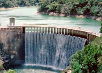
6 Background Site Conditions 1. SC Dam built in 1921 a. 106 feet tall concrete arch dam b miles from Pacific c. Confluence with San Clemente Creek upstream of dam d. Reservoir storage of approximately 1,425 acre-feet 2. Under current conditions a. Reservoir filled with approx. 2.5 million CY of sediment b. Capacity reduced to approx. 70 acre-feet Slide 5 of 30

7 San Clemente Dam Under Construction

8 San Clemente Dam - Today
9 Background Milestone Summary 1. DWR issued a dam safety order in early 1990s 2. DWR released DEIS/R in Final EIR/S certified in Design & permitting is moving forward with cooperative agreement between California American Water (CAW), State Coastal Conservancy (SCC) and National Marine Fisheries Service (NMFS) 5. SCC and NMFS will secure up to $35 million in additional funding 6. Joint Planning Commission/CVLUAC Site Visit - May 23, CVLUAC recommended approval - July 2, 2012 Slide 8 of 30
10 Project Overview Slide 9 of 30
11 1. Primary Goals Project Overview Goals & Objectives a. Provide a long-term solution to dam safety issue b. Improve fish passage conditions and provide rearing habitat c. Diminish potential for excessive erosion, undermining, or slope failure, leading to sediment mobilization d. Avoid exacerbating downstream flooding 2. Secondary Goals a. Restore natural character and function of valley bottom b. Shape project components to be as natural as feasible c. Provide long-term sustainable habitat d. Promote more natural sediment transport regime Slide 10 of 30

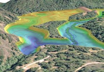
12 Project Overview Existing Conditions Slide 11 of 30

13 Project Overview Proposed Features Upper Carmel River Reach Upper San Clemente Creek Reroute Channel Access Road Design Diversion Dike Combined Flow Reach Sediment Stockpile Area Stabilized Sediment Slope & East Tributary Dam Removal Old Carmel River Dam Removal Slide 12 of 30


14 Project Overview Pre- and Post- Comparison Proposed Conditions Existing Conditions Slide 13 of 30


15 URS2 Project Overview OCRD Removal Slide 14 of 30
16 Slide 14 URS2 URS, 07/17/2012
17 Tree Removal/Mitigation Slide 15 of 30


18 Tree Survey Fall 11 Survey 2,490 trees Oak, fir, bay, cottonwood box elder willow sycamore madrone San Clemente Creek Oaks> 6 in Staging Areas Access Road Slide 16 of 30

19 Tree Removal Design Modifications Avoid: 893 perimeter & 251 access road trees Slide 17 of 30

20 Tree Mitigation Revegetation Plan Local, native species >14,000 trees >10K riparian Oak mitigation Plant 1,514 coast live oak 3:1 for < 24 2 ft 10:1 for > 24 diam Big Sur Land Trust Accumulating funds for Monterey Co. Oak Woodland Conservation Fund (conservation easement) Slide 18 of 30

21 Existing Site Slopes 25% Slope Map Slide 19 of 22
22 Construction Access Slide 20 of 30

23 Construction Access Proposed Access Route Map Slide 21 of 30

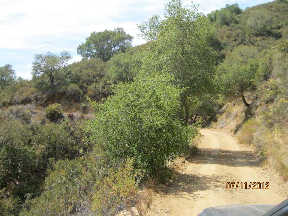
24 Construction Access Jeep Trail/Reservoir Access Road Slide 22 of 30
25 Construction Access Access Route Alternatives Summary 1. Three initial options: a. San Clemente Drive to the Low Road (Low Road option) NOT FEASIBLE b. San Clemente Drive to the High Road (High Road option) c. Cachagua Road to the Jeep Trail (Jeep Trail option) 2. Alternative Analysis Summary - Compared to the Jeep Trail Option, the High Road option results in approximately: a. 2,800 linear feet of additional road improvement, b. 300 linear feet of additional new road construction, and c. 3 additional new or replacement bridges d. 50% increase in the number of trees impacted e. 4.5 additional acres of new road construction disturbance area 3. Jeep Trail Option selected for Project Slide 23 of 30
26 Access Route Option Summary
27
28 Parking for Construction Workers Access road improvements begin - fall On-site parking at dam limited to 12 spaces. During initial phase, use existing park and ride lots at: 1) Laureles Grade/Highway 68 (19 spaces); and 2) the Crossroads Shopping Center (33 spaces). Once work starts on dam removal, new temporary park and ride lots will be constructed in Carmel Valley for 80 workers.
29 Landscape Restoration Plan Riparian: 19.8 acres of riparian vegetation will be planted along reconstructed river. Wetland: 3 acres of wetlands will be restored to achieve a no net loss of wetland and provide habitat for California Red Legged Frog. Upland: Oak woodlands, chaparral and scrub are proposed for upland restoration in appropriate locations.


30 Sensitive Habitat Mitigation Existing & Proposed Habitat Existing Proposed Slide 28 of 30
31 Recommendation Staff recommends that the Planning Commission conduct a workshop. Issues the Commission may want to discuss include: Are the proposed tree removals the minimum necessary to implement the project? Is the proposed primary construction access route (i.e., Tassajara Road through Cachagua Road and the Jeep Trail from the southeast) the preferred route? Are there any alternatives that could lessen the construction period impacts, particularly in regard to the road improvements proposed on the construction access routes along Cachagua Road and the Jeep Trail?

32 Questions? Visit us at: Slide 30 of 30
33 Pocket Slides Slide 31 of 22
 b. Los Padres Dam Downstream Fish Passage Facility (CAW) c. Sleepy Hollow Bridge (MPWMD) d.")
34 Project Overview Watershed & River Context 1. Watershed Trends: a. Ecological restoration of Carmel River and streams b. Emphasis on steelhead passage and population 2. Ongoing Projects: a. Carmel River Reroute & San Clemente Dam Removal (CAW) b. Los Padres Dam Downstream Fish Passage Facility (CAW) c. Sleepy Hollow Bridge (MPWMD) d. Lower Carmel River Floodplain Restoration and Enhancement (Big Sur Land Trust) e. Carmel River Lagoon Ecosystem Protection Barrier (Monterey County) Slide 32 of 30
35 Project Overview Timeline June 2012: RFP out to shortlisted D-B Teams September 2012: D-B Proposals due Begin Access Road Construction December 2012: D-B Team selection March 2013: Execute D-B Agreement D-B begins Diversion Design May 2013: D-B begins Diversion Construction, Geotechnical Investigations, and Site Design 2013 to 2015: Majority of Site Construction 2015 to 2020: D-B Post Construction Phase Slide 33 of 30
36 Construction Access Access Route Traffic Use 1. Cachagua Road/Jeep Trail a. Buses from Park and Ride (Location TBD) for most workers b. Some personal vehicles c. Construction material in single unit haulers 2. Tassajara Road/Cachagua Road/Jeep Trail a. Construction equipment mobilization b. Any construction material that would not be able negotiate Cachagua Road 3. San Clemente Drive a. Limited personal vehicles b. Limited trucks (1 to 2 ton) Slide 34 of 30
37 Project Overview CEQA & Permitting Overview CEQA / NEPA (Final EIS/R 2007) SEIR DWR SEIR (OCRD) State Coastal Conservancy Monterey County Combined Development Permit Grading permit Encroachment permit CWA 404 permit USACE ESA 7 Biological Opinions NMFS & FWS NHPA 106 Concurrence SHPO CWA 401 Water Quality Certification RWQCB CWA 404(b)(1) Alternatives Analysis EPA CF&G Code 1600 Lake & Streambed Alteration Agreement CESA 2081 incidental take permit CDFG NPDES SWPPP approval RWQCB Slide 35 of 30

38 Construction Access Equipment Mobilization Traffic Estimate 1. Heavy Equipment Mobilization a. Extended flatbed to bring in large equipment or crane; Mobile material processing plant. b. Route: Tassajara Road to Cachagua Road to Jeep Trail ONLY 2. Equipment Mobilization Estimates: a. Typically would involve 0-5 round trips per month b. Monthly round trip peaks as follows: i. 1st year of site construction 25 at start of season, 20 at end of season ii. 2nd year of site construction 40 at start of season, 45 at end of season iii. 3rd year of site construction 30 at start of season, 15 at end of season Slide 36 of 30
39 Construction Access Traffic Safety 1. Traffic Control Plan by Contractor; Approved by County 2. Coordinate with Cachagua Fire District a. 24-hour contact name and number b. Copy of approved Traffic Control Plan c. Updates to traffic estimates (monthly breakdown) 3. Pilot Cars will be required for a. Construction equipment mobilization b. Construction material hauling 4. Flagman required public road construction 5. Signage 6. Adherence to speed limits on all public roads will be emphasized 7. Material hauling will be restricted to: a. 9 am to 3 pm Monday through Friday b. No hauling when school buses are scheduled to run Slide 37 of 30
40 Construction Access Traffic Daily Average Trips Slide 38 of 30
41 Construction Access Material Hauling 1. Construction Materials Imported to Site a. Pipe, valves, etc. for diversion b. Aggregate base for access roads c. Imported aggregates for filter materials d. Cement for soil improvement using deep soil mixing (DSM) 2. Construction Materials Removed from Site a. Demolition debris (metal, wood, sheetrock, pipe, etc.); concrete will be buried on site Slide 39 of 30
MONTEREY PENINSULA WATER MANAGEMENT DISTRICT PROJECT DESCRIPTION FOR SELECTIVE VEGETATION MANAGEMENT AND BANK RESTORATION (RANCHO SAN CARLOS AREA)
") MONTEREY PENINSULA WATER MANAGEMENT DISTRICT PROJECT DESCRIPTION FOR SELECTIVE VEGETATION MANAGEMENT AND BANK RESTORATION (RANCHO SAN CARLOS AREA) IN THE CARMEL RIVER CHANNEL, SUMMER AND FALL 2014 SELECTIVE
MONTEREY PENINSULA WATER MANAGEMENT DISTRICT PROJECT DESCRIPTION FOR SELECTIVE VEGETATION MANAGEMENT AND BANK RESTORATION (RANCHO SAN CARLOS AREA) IN THE CARMEL RIVER CHANNEL, SUMMER AND FALL 2014 SELECTIVE
Water and Environment. Monterey Peninsula, Carmel Bay and South Monterey Bay Integrated Regional Water Management Draft Plan
 Water and Environment Monterey Peninsula, Carmel Bay and South Monterey Bay Integrated Regional Water Management Draft Plan December 11, 2006 Presentation Outline Purpose of IRWM Planning Status of Plan
NOTICE OF PREPARATION
 NOTICE OF PREPARATION Date: June 12, 2014 To: From: Subject: Governor s Office of Planning and Research/State Clearinghouse Unit, Responsible Agencies, Trustee Agencies, and Interested Parties Announcement
A Review of the San Clemente Dam Removal & Carmel River Reroute Project
 A Review of the San Clemente Dam Removal & Carmel River Reroute Project Kevan Urquhart, Senior Fisheries Biologist & Carmel River Watermaster MPWMD Project Roles: 1) CDFW rep 2001-2006; 2) Technical Advisory
Sacramento Area Flood Control Agency. May State Clearinghouse No Prepared for: Prepared by: Consulting Engineers and Scientists
 Addendum No. 3 (North Sacramento Streams) to the Environmental Impact Report on the North Sacramento Streams, Sacramento River East Levee, Lower American River, and Related Flood Improvements Project Prepared
DECISION MEMO FOR CATEGORICAL EXCLUSION HOLY JIM CREEK CROSSING REPLACEMENT
 DECISION MEMO FOR CATEGORICAL EXCLUSION HOLY JIM CREEK CROSSING REPLACEMENT U.S.D.A. Forest Service Cleveland National Forest Trabuco Ranger District Orange County, California Background The current configuration
E. Other Federal Requirements and CEQA Considerations
 E. Other Federal Requirements and CEQA Considerations Section E.1 includes discussions of various topics required by NEPA and/or CEQA, including a description of the long-term implications of the Project,
Notice of Preparation of Environmental Impact Report
 Notice of Preparation of Environmental Impact Report September 29, 2010 TO: State Clearinghouse Responsible and Trustee Agencies Interested Agencies and Parties FROM: Sonoma County Water Agency 404 Aviation
Public Notice. Public Notice No. Date: April 8, 2016 CENAP-PL-E Comment Period Closes: May 9, 2016
 Public Notice Public Notice No. Date: April 8, 2016 CENAP-PL-E-16-02 Comment Period Closes: May 9, 2016 USACE Philadelphia District: http://www.nap.usace.army.mil COBBS CREEK FISH PASSAGE PROJECT SECTION
SECTION 4.0 ALTERNATIVES
 SECTION 4.0 ALTERNATIVES 4.1 CEQA REQUIREMENTS The key requirements under the California Environmental Quality Act (CEQA) to identify and evaluate alternatives in an Environmental Impact Report (EIR) are
WATERSHED MANAGEMENT INITIATIVE: GOALS & IMPLEMENTATION OBJECTIVES, JULY 26, 1999
 WATERSHED MANAGEMENT INITIATIVE: GOALS & IMPLEMENTATION OBJECTIVES, JULY 26, 1999 The following table indicates the draft goals and objectives for the Santa Clara Basin WMI process. The overall objectives
Accelerating Restoration Projects on Private Lands with the Partners in Restoration (PIR) Permit Coordination Program. Analysis Draft Recommendations
 Permit Coordination Program. Analysis Draft Recommendations") Accelerating Restoration Projects on Private Lands with the Partners in Restoration (PIR) Permit Coordination Program GavPac Committee Meeting, Gaviota, CA December 15, 2010 Analysis Draft Recommendations
Accelerating Restoration Projects on Private Lands with the Partners in Restoration (PIR) Permit Coordination Program GavPac Committee Meeting, Gaviota, CA December 15, 2010 Analysis Draft Recommendations
Stream Crossing Reconstruction on the Bog Dam Loop Road (FR15) Scoping Notice. Androscoggin Ranger District
 Scoping Notice. Androscoggin Ranger District") United States Department of Agriculture Forest Service White Mountain National Forest Stream Crossing Reconstruction on the Bog Dam Loop Road (FR15) Scoping Notice Androscoggin Ranger District Androscoggin
United States Department of Agriculture Forest Service White Mountain National Forest Stream Crossing Reconstruction on the Bog Dam Loop Road (FR15) Scoping Notice Androscoggin Ranger District Androscoggin
There is a reliable, clean water supply for current and future generations.
 E2 There is a reliable, clean water supply for current and future generations. E2.1. Current and future water supply for municipalities, industries, agriculture, and the environment is reliable. 2.1.1.
PROJECT HIGHLIGHTS,
 PROJECT HIGHLIGHTS, 2012-003 935 linear feet of fence encompassing livestock pond 1 water tank, 2 water troughs, 3800 linear feet pipeline Project: 2012-003 Watershed: Tomales Bay, East Shore Practices:
Responses to Comments from State Agencies
 Summary of Comment Letters Received from State Agencies This section provides responses to comments received on the draft environmental document from state agencies. Comment Code Agency S-1 California
Wapato Access Feasibility Study
 Wapato Access Feasibility Study David Gorman, PE Michael Rounds, PE August 5, 2011 Lower Columbia River Estuary Partnership (LCREP) Non-profit two state public-private initiative Primary Responsibility:
Case Studies III: Skokomish River Ecosystem Restoration Washington State
 University of Massachusetts - Amherst ScholarWorks@UMass Amherst International Conference on Engineering and Ecohydrology for Fish Passage International Conference on Engineering and Ecohydrology for Fish
3F. Hydrology and Water Quality
 This section provides an analysis of potential hydrological and water quality impacts associated with implementation of the proposed project. The section also evaluates and describes the potential impacts
Wood Canyon Emergent Wetland Project. City of Aliso Viejo 12 Journey, Suite 100 Aliso Viejo, CA 92656
 Wood Canyon Emergent Wetland Project City of Aliso Viejo 12 Journey, Suite 100 Aliso Viejo, CA 92656 Introduction Wood Canyon is located within Aliso and Wood Canyon Regional Park in southwest Orange County,
Temporary Stream Crossing
 Categories EC Erosion Control SE Sediment Control TC Tracking Control WE Wind Erosion Control Non-Stormwater NS Management Control Waste Management and WM Materials Pollution Control Legend: Primary Objective
Temporary Stream Crossing
 Temporary Stream Crossing NS-4 Objectives EC Erosion Control SE Sediment Control TR Tracking Control WE Wind Erosion Control Non-Stormwater NS Management Control Waste Management and WM Materials Pollution
Draft Environmental Impact Report
 Revised Draft Environmental Impact Report San Francisquito Creek Flood Protection, Ecosystem Restoration, and Recreation Project Upstream of Highway 101 This notice announces that a Draft Environmental
CATEGORY a protection of the natural environment, its ecosystems and biodiversity.
 29. ENVIRONMENTAL DEVELOPMENT PERMIT AREA CATEGORY a protection of the natural environment, its ecosystems and biodiversity. The requirement to obtain an environmental development permit is cited in Section
Logan River at Rendezvous Park, Channel and Floodplain Restoration: Crack Willow (Salix fragilis) Issues and Management Strategies
 Issues and Management Strategies") Logan River at Rendezvous Park, Channel and Floodplain Restoration: Crack Willow (Salix fragilis) Issues and Management Strategies Prepared May 2, 2017 by Darren Olsen, BIO-WEST, Inc. Issues Crack willow
Logan River at Rendezvous Park, Channel and Floodplain Restoration: Crack Willow (Salix fragilis) Issues and Management Strategies Prepared May 2, 2017 by Darren Olsen, BIO-WEST, Inc. Issues Crack willow
Upper Santa Clara River Watershed Arundo/ Tamarisk Removal Program (SCARP)
") Upper Santa Clara River Watershed Arundo/ Tamarisk Removal Program (SCARP) California Invasive Plant Council 15 th Annual Symposium October 5, 2006 Ventura County Resource Conservation District Upper Santa
Upper Santa Clara River Watershed Arundo/ Tamarisk Removal Program (SCARP) California Invasive Plant Council 15 th Annual Symposium October 5, 2006 Ventura County Resource Conservation District Upper Santa
APPENDIX N Guidance for Preparing/Reviewing CEQA Initial Studies and Environmental Impact Reports
 APPENDIX N N.1 Guidance for Preparing and Reviewing CEQA Initial Studies Step 1: Consider the Project Characteristics as Provided by the Project Applicant Review the project application and draft plan
Programmatic Environmental Compliance and Permitting for Invasive Weed Control and Habitat Restoration Projects. Presented by: Ron Unger
 Programmatic Environmental Compliance and Permitting for Invasive Weed Control and Habitat Restoration Projects Presented by: Ron Unger October 2, 2003 1 Benefits of Programmatic Compliance Enables new
Appendix D - Evaluation of Interim Solutions
 Appendix D - Evaluation of Interim Solutions D.1 Introduction The implementation of long-term improvements is projected to take 5 to 8 years. To reduce the number of years of flooding impacts, the partner
RECORD OF DECISION I. INTRODUCTION
 RECORD OF DECISION As the District Commander for the Los Angeles District, I have reviewed the Final Environmental Impact Statement/Environmental Impact Report (EIS/EIR) for the Newhall Ranch Resource
David Brockbank, Senior Planner Contra Costa County Department of Conservation and Development 30 Muir Road Martinez, CA, 94553
 WRITTEN COMMENTS: Interested agencies and the public may also submit written comments to the County. Please submit your comments at the earliest possible date, but no later than 5 p.m. on Friday, November
Removal of the Last Fish Barrier on the Lower Rogue River Shane K. Cline, PE HDR Inc, Portland, OR
 Removal of the Last Fish Barrier on the Lower Rogue River Shane K. Cline, PE HDR Inc, Portland, OR ,, Jackson Co., OR ,, Jackson Co., OR Project History Located in Jackson County on the Rogue River Log
1. Red Clover Poco Restoration Project Environmental Permitting
 1. Red Clover Poco Restoration Project Environmental Permitting 2. County: Plumas 3. Project Number: 4. Project Sponsor: Plumas Corporation (contact Leslie Mink); USDA- Plumas National Forest 5. Date:
The F.O.R.C.E. The Future Of Redwood Creek Environment
 The F.O.R.C.E. The Future Of Redwood Creek Environment Robert Andersen Katelyn Csatari Achyuth Madabhushi Julie Swanson Overview Mission Statement Watershed Characterization Land and Water Use History
Santa Clara Valley Habitat Plan Regional General Permit #18. Training and Workshop for Co-Permittees April 5, 2016
 Santa Clara Valley Habitat Plan Regional General Permit #18 Training and Workshop for Co-Permittees April 5, 2016 Agenda Welcome and Objectives (5 min.) Overview of Regional General Permit #18 (40 min.)
Chehalis Basin Strategy Programmatic SEPA Draft EIS
 Chehalis Basin Strategy Programmatic SEPA Draft EIS History of Flooding I-5 closed in 1990, 1996, 2007, 2009 Five largest flood events occurred since 1986 2 History of Habitat Degradation Harvest has been
LAKE COUNTY STORMWATER MANAGEMENT COMMISSION GENERAL PERMIT NUMBER 3 AUTHORIZING MINOR MAINTENANCE DREDGING ACTIVITIES
 I. INTRODUCTION This document is created under the authorities granted to the Lake County Stormwater Management Commission (LCSMC) with respect to the Lake County Watershed Development Ordinance (WDO)
Southern California River and Stream Habitats
 Southern California River and Stream Habitats Climate Change Adaptation Actions Summary An Important Note About this Document: This document represents an initial effort to identify adaptation actions
Public Notice. CENAB-OPR-P P24 (Lime Spring Run)
") U.S. Army Corps of Engineers Baltimore District Public Notice In Reply to Application Number CENAB-OPR-P-2016-00168-P24 (Lime Spring Run) PN-17-16 Comment Period: April 3, 2017 to May 3, 2017 THE PURPOSE
U.S. Army Corps of Engineers Baltimore District Public Notice In Reply to Application Number CENAB-OPR-P-2016-00168-P24 (Lime Spring Run) PN-17-16 Comment Period: April 3, 2017 to May 3, 2017 THE PURPOSE
Local Flood Hazard Mitigation Program. A framework for hazard mitigation in the NYC West of Hudson Water Supply Watersheds
 Local Flood Hazard Mitigation Program A framework for hazard mitigation in the NYC West of Hudson Water Supply Watersheds Flood Hazard Mitigation Defined 2 2 Presentation Overview Why and how is the NYC
Department of the Army Permit Application
 Department of the Army Permit Application DA File Number U.S. Army Corps of Engineers Honolulu District Date Received by CEPOH-RO Send Completed Application to: Honolulu District, U.S. Army Corps of Engineers
Mixed Conifer Working Group Meeting April 15, 2011 Water and Soil Resource Management Considerations
 Mixed Conifer Working Group Meeting April 15, 2011 Water and Soil Resource Management Considerations It is difficult to tie watershed health directly to mixed-conifer forests. Watersheds encompass a variety
PUBLIC NOTICE Application for Permit
 PUBLIC NOTICE Application for Permit Issue Date: March 4, 2016 Expiration Date: April 4, 2016 US Army Corps of Engineers No: NWP-2015-432 30-Day Notice Oregon Department of State Lands No: 58511 Interested
Public Information Centre September 19 th, 2017
 Public Information Centre September 19 th, 2017 WELCOME! Public Information Centre for the Maple Hill Creek Rehabilitation Class Environmental Assessment Please take the time to sign our sign in sheet
Calleguas Creek Watershed Wetland Restoration Plan. David L. Magney. David Magney Environmental Consulting
 Calleguas Creek Watershed Wetland Restoration Plan David L. Magney David Magney Environmental Consulting Calleguas Creek Watershed About the Watershed Located in southeastern Ventura County Drains 343
LEGAL AUTHORITY AND JURISDICTIONS
 CALIFORNIA DEPARTMENT OF FISH AND GAME RIPARIAN RESOURCES AND REGULATORS: The DFG Lake and Streambed Alteration 1600 Process LEGAL AUTHORITY AND JURISDICTIONS Serge Glushkoff CENTRAL COAST REGION YOUNTVILLE
Klamath River Renewal Project Dam Removal RFQ Informational Meeting August 29, 2018 Klamath Falls, OR
 Klamath River Renewal Project Dam Removal RFQ Informational Meeting August 29, 2018 Klamath Falls, OR Agenda Time 1:00pm 2:00pm 3:00pm Item Presentation on Design-Build RFQ 1. Room Safety 2. Project Background
National Marine Fisheries Service ESA/MSA Restoration Project Consultations. Oregon State Habitat Office Oregon Coast Branch Roseburg, Oregon
 National Marine Fisheries Service ESA/MSA Restoration Project Consultations Ken Phippen Jeff Young Oregon State Habitat Office Oregon Coast Branch Roseburg, Oregon NMFS Consultation Authorities Endangered
Conceptual Design and Feasibility of a Natural Fishway at the Fremont BART Weir, Alameda Creek, California
 Conceptual Design and Feasibility of a Natural Fishway at the Fremont BART Weir, Alameda Creek, California Final Report September 2005 Prepared by Center for Ecosystem Management and Restoration, Oakland,
RE: Recommendations for Staged Implementation of Alternative 3a
 March 10, 2006 Ms. Julie Thomas Coastal San Luis Resource Conservation District 545 Main Street, Suite B-1 Morry Bay, Ca 93442 RE: Recommendations for Staged Implementation of Alternative 3a Dear Ms. Thomas,
PRESENTERS. Contact Information: RW Armstrong Union Station, 300 S. Meridian St. Indianapolis, IN
 1 PRESENTERS David Bourff, Director of Environmental Planning Simon Davies, LEED AP, Environmental Scientist Summer O Brien, PWS, Senior Environmental Scientist Contact Information: RW Armstrong Union
MANZANITA LAKE PLANNING UNIT Willow Creek Watershed
 Existing Conditions & Uses Overview Area surrounding a small afterbay and creeks with ethnobotanical resources and valuable habitat 472 acres in Madera County; 337 acres outside the FERC boundary and 135
CHAPTER 7. San Dieguito River Flooding Adaptation
 CHAPTER 7 San Dieguito River Flooding Adaptation This chapter includes a range of adaptation measures to address vulnerabilities from flooding along the San Dieguito River, including the river valley,
Flooding from Butano Creek on Pescadero Road
 Developing Solutions to Flooding from Butano Creek on Pescadero Road Chris Bowles, PhD, PE Chris Hammersmark, PhD, PE Ethan Bell, MS October 1, 2013 Outline Objectives Funding Qualifications Approach Schedule
Public Notice of Application for Permit
 US Army Corps of Engineers Alaska District ANCHORAGE Regulatory Division (1145) CEPOA-RD Post Office Box 6898 JBER, Alaska 99506-0898 Public Notice of Application for Permit PUBLIC NOTICE DATE: July 31,
Nationwide Permit General Conditions
 Nationwide Permit General Conditions 1. Navigation 2. Aquatic Life Movements 3. Spawning Areas 4. Migratory Bird Breeding Areas 5. Shellfish Beds 6. Suitable Material 7. Water Supply Intakes 8. Adverse
Terry Benoit 4/1/2009
 FRCRM FORUM FULL PROPOSAL SPANISH CREEK IN AMERICAN VALLEY Terry Benoit 4/1/2009 1. Project Name: Spanish Creek in American Valley 2. County: Plumas 3. Project Number: 4. Project Sponsor: Plumas Corporation
The Nature Conservancy Cosumnes River Preserve Franklin Boulevard Galt CA 95632
 Study Partners The Nature Conservancy Cosumnes River Preserve 13501 Franklin Boulevard Galt CA 95632 East Bay Municipal Utility District 1 Winemaker Way, Unit K Lodi CA 95240 Sacramento County Water Agency
5.2 BIOLOGICAL RESOURCES AND WETLANDS
 5.2 BIOLOGICAL RESOURCES AND WETLANDS 5.2.1 INTRODUCTION This section discusses potential adverse effects to vegetation communities and special status species. Effects would be considered adverse if the
PUBLIC NOTICE. Section 404 of the Clean Water Act (33 U.S.C. 1344) Section 10 of the Rivers and Harbors Act of 1899 (33 U.S.C.
 Section 10 of the Rivers and Harbors Act of 1899 (33 U.S.C.") US Army Corps Of Engineers Wilmington District PUBLIC NOTICE Issue Date: June 17, 2014 Comment Deadline: July 17, 2014 Corps Action ID#: SAW-2009-00655 NC DOT TIP: R-4903 The Wilmington District, Corps
US Army Corps Of Engineers Wilmington District PUBLIC NOTICE Issue Date: June 17, 2014 Comment Deadline: July 17, 2014 Corps Action ID#: SAW-2009-00655 NC DOT TIP: R-4903 The Wilmington District, Corps
INTRODUCTION AND BACKGROUND
 INTRODUCTION AND BACKGROUND Duke Energy Carolinas, LLC (Duke) operated the Dillsboro Hydroelectric Project under a license from the Federal Energy Regulatory Commission (FERC No. 2602). The Project is
Agency Organization Organization Address Information. Name United States Department of Agriculture
 Logo Department Name United States Department of Agriculture Agency Organization Organization Address Information Forest Service Pacific Northwest Region 1220 SW Third Avenue (97204) P.O. Box 3623 Portland,
Moonlight Aquatic Organism Passage Project
 Notice of Proposed Action Moonlight Aquatic Organism Passage Project Mt. Hough Ranger District Plumas National Forest Plumas County, California Figure 1. Hungry 1 aquatic organism passage outlet showing
U.S. ARMY CORPS OF ENGINEERS BUILDING STRONG LOS ANGELES DISTRICT
 PUBLIC NOTICE U.S. ARMY CORPS OF ENGINEERS BUILDING STRONG LOS ANGELES DISTRICT APPLICATION FOR PERMIT Gate King Properties, LLC Tract 50283 Public Notice/Application No.: SPL-2011-01067-GS Project: Gate
Projects must fall under one of the nine categories listed in Table 1.
 UNITED STATES DEPARTMENT OF COMMERCE National Oceanic and Atmospheric Administration NATIONAL MARINE FISHERIES SERVICE West Coast Region Snake Basin Office 800 Park Boulevard, Plaza IV, Suite 220 Boise,
SHORELINE INVENTORY AND RESTORATION PLANNING
 CHAPTER 3 SHORELINE INVENTORY AND RESTORATION PLANNING A. PURPOSE OF THE SHORELINE INVENTORY AND CHARACTERIZATION A first step in the comprehensive Master Program update process is development of a shoreline
Pacheco Reservoir Expansion
 California Water Commission Pacheco Reservoir Expansion Unique Opportunity for Fisheries Recovery, Flood Risk Reduction and Emergency Water Supply December 13, 2017 1 of 33 Project Partners Pacheco Pass
Nationwide Permit General Conditions
 Nationwide Permit General Conditions Note: To qualify for NWP authorization, the prospective permittee must comply with the following general conditions, as applicable, in addition to any regional or case-specific
Appendix Q Conceptual Mitigation Plan for Impacts to Wetlands and Other Waters of the United States
 for Impacts to Wetlands and Other Waters of the United States Q.1 Introduction This Conceptual Mitigation Plan (Plan) is intended to provide a framework for identifying the potential mitigation areas and
FLOODPLAIN PERMIT APPLICATION SUBMITTAL REQUIREMENTS
 Planning Department 215 South 4 th Street, Suite F Hamilton, MT 59840 Phone 406-375-6530 Fax 406-375-6531 planning@rc.mt.gov FLOODPLAIN PERMIT APPLICATION SUBMITTAL REQUIREMENTS To initiate the permit
CIP-01: Stream Channel Stabilization, Silver Creek
 CIP-01 CIP-01: Stream Channel Stabilization, Silver Creek HIGHEST PRIORITY This project consists of stream channel stabilization to address channel incision and the replacement of two cross-culverts. Preferred
Folsom Dam Water Control Manual Update
 Folsom Dam Water Control Manual Update Stakeholder Discussion October 31, 2013 Location: Tsakopoulos Library Galleria, East Room, 828 I Street, Sacramento US Army Corps of Engineers WELCOME & INTRODUCTIONS
STAFF UPDATES FLOOD ZONE 9 ADVISORY BOARD MEETING
 STAFF UPDATES FLOOD ZONE 9 ADVISORY BOARD MEETING Ross Valley Watershed Flood Risk Reduction Program RossValleyWatershed.org Contact us: 415 473 7226; lizlewis@marincounty.org February 16, 2017 Photo:
COASTAL CONSERVANCY. Staff Recommendation September 22, 2011 GREEN VALLEY CREEK COHO HABITAT ENHANCEMENT DESIGN
 COASTAL CONSERVANCY Staff Recommendation September 22, 2011 GREEN VALLEY CREEK COHO HABITAT ENHANCEMENT DESIGN Project No. 07-106-02 Project Manager: Lisa Ames RECOMMENDED ACTION: Authorization to disburse
Public Notice. Applicant: City of Dallas Project No.: SWF Date: April 18, Name: Chandler Peter Phone Number:
 Public Notice Applicant: City of Dallas Project No.: SWF- 2014-00151 Date: April 18, 2014 The purpose of this public notice is to inform you of a proposal for work in which you might be interested. It
NOTICE OF PREPARATION OF AN ENVIRONMENTAL IMPACT REPORT
 Date: September 18, 2017 NOTICE OF PREPARATION OF AN ENVIRONMENTAL IMPACT REPORT To: Agencies and Interested Parties Lead Agency: Sacramento Municipal Utility District 6201 S Street, MS H201 Sacramento,
Proposal for Plumas Watershed Forum. 1. Project Name: Feather River Irrigated Lands Water Quality Improvement Program.
 Proposal for Plumas Watershed Forum 1. Project Name: Feather River Irrigated Lands Water Quality Improvement Program. 2. County: The project area encompasses Plumas County and parts of Sierra and Lassen
Response: Eastern Shore will require additional permanent easement and temporary workspace (TWS) in the following municipalities:
 in the following municipalities:") 2. There are multiple properties throughout the Chester County portion of the 2017 Expansion Project area which contain preservation easements on them. Eastern Shore Natural Gas Company should be aware
2. There are multiple properties throughout the Chester County portion of the 2017 Expansion Project area which contain preservation easements on them. Eastern Shore Natural Gas Company should be aware
3.0 CUMULATIVE PROJECTS SCENARIO
 3.0 CUMULATIVE PROJECTS SCENARIO The CEQA Guidelines define cumulative impacts as two or more individual effects that, when considered together, are considerable or which compound or increase other environmental
Funding And Monitoring. Cobbling it together Focus on watersheds and streams in North Bay
 Funding And Monitoring Cobbling it together Focus on watersheds and streams in North Bay Method of Research Acknowledgements Slides from Napa RCD, Sonoma Ecology Center, Cal Trout, SPAWN, Marin RCD, Rutherford
Portland District Regulatory Branch Permit Streamlining for Restoration Projects
 Portland District Regulatory Branch Permit Streamlining for Restoration Projects Shawn Zinszer December 7, 2011 Carol Franson December 6, 2011 Regulatory Branch Portland District US Army Corps of Engineers
DEPARTMENT OF THE ARMY U.S. ARMY CORPS OF ENGINEERS, SACRAMENTO DISTRICT 1325 J STREET SACRAMENTO CA PUBLIC NOTICE
 DEPARTMENT OF THE ARMY U.S. ARMY CORPS OF ENGINEERS, SACRAMENTO DISTRICT 1325 J STREET SACRAMENTO CA 95814-2922 Operations and Readiness Branch PUBLIC NOTICE REQUEST FOR PERMISSION TO MODIFY A U.S. ARMY
~ate: d~o/~o/h. h ~~~ Date:,;z//o/a?0/6. Managing Water in the West. Upper Sacramento River Anadromous Fish Habitat Restoration Project
 M Managing Water in the West Finding of No Significant Impact Upper Sacramento River Anadromous Fish Habitat Restoration Project Recommended by: ~~ Ben Nelson Natural Resources Specialist Bay-Delta Office
Public Notice: Application for Permit
 US Army Corps Of Engineers Walla Walla District 201 North Third Avenue Walla Walla, WA 99362-1876 Public Notice: Application for Permit APPLICATION NO.: NWW-2012-127-I02 WATERWAY: Big Wood River APPLICANT:
Parks and Open Space 5201 St. Vrain Road Longmont, Colorado Fax:
 Parks and Open Space 5201 St. Vrain Road Longmont, Colorado 80503 303.678.6200 Fax: 303.678.6177 www.bouldercounty.org HALL RANCH 2 ACCESS ROAD REPAIRS Project Summary for Limited Impact Special Use Review
Prioritizing Local Action. Strengthening the Resilience of the Taunton River Watershed
 Prioritizing Local Action Strengthening the Resilience of the Taunton River Watershed No Really, We re Here to Help 6/12/14 Healthy and Resilient Taunton Watershed Project EPA s Healthy Watershed Program
Boardman River Dams Committee (BRDC) Detailed Analysis of Alternatives
 Detailed Analysis of Alternatives") Boardman River Dams Committee (BRDC) Detailed Analysis of Alternatives Presentation Outline Summary of Detailed Analysis Summary of Cost and Economic Impacts Public Opinion Survey Questions and Discussion
Boardman River Dams Committee (BRDC) Detailed Analysis of Alternatives Presentation Outline Summary of Detailed Analysis Summary of Cost and Economic Impacts Public Opinion Survey Questions and Discussion
WHETSTONE RIVER RESTORATION PROJECT - ADDENDUM
 DRAFT WHETSTONE RIVER RESTORATION PROJECT - ADDENDUM Upper Minnesota Watershed District February 2, 2015 I hereby certify that this plan, specification, or report was prepared by me or under my direct
Notice of Preparation
 Notice of Preparation Date April 23, 2015 To: Subject: Project: Lead Agency: California Office of Planning and Research, Responsible and Trustee Agencies and Interested Parties Notice of Preparation of
CHAPTER 3 Environmental Guidelines for WATERCOURSE CROSSINGS GOVERNMENT OF NEWFOUNDLAND AND LABRADOR DEPARTMENT OF ENVIRONMENT AND LABOUR
 GOVERNMENT OF NEWFOUNDLAND AND LABRADOR DEPARTMENT OF ENVIRONMENT AND LABOUR CHAPTER 3 Environmental Guidelines for WATERCOURSE CROSSINGS WATER RESOURCES MANAGEMENT DIVISION Water Investigations Section
California WaterFix (Alternative 4A)/Recirculated Environmental Analysis Frequently Asked Questions
/Recirculated Environmental Analysis Frequently Asked Questions") Updated August 2015 California WaterFix (Alternative 4A)/Recirculated Environmental Analysis Frequently Asked Questions 1. What is the purpose and need for California WaterFix (Alternative 4A)? The California
Updated August 2015 California WaterFix (Alternative 4A)/Recirculated Environmental Analysis Frequently Asked Questions 1. What is the purpose and need for California WaterFix (Alternative 4A)? The California
Site 18A Culvert Replacement and Fish Passage Enhancement Project
 EXHIBIT C Final Mitigation Monitoring and Reporting Program for the Site 18A Culvert Replacement and Fish Passage Enhancement Project SCH#2015042009 Prepared for: May 8, 2015 Final Mitigation Monitoring
Assessing Habitat in Watersheds. Sabrina Drill UC Cooperative Extension Los Angeles and Ventura
 Assessing Habitat in Watersheds Sabrina Drill UC Cooperative Extension Los Angeles and Ventura sldrill@ucdavis.edu 323-260 260-3404 What is Habitat? The environment in which a plant and animal lives, and
The Los Vaqueros Reservoir Expansion Project
 The Los Vaqueros Reservoir Expansion Project Marguerite Patil Special Assistant to the General Manager Contra Costa Water District SCVWD/CCWD Joint Meeting July 14, 2016 Today s Itinerary 11:00 11:50 Presentation
' MY () Interim Risk Reduction Measures Grubbing in Cleared Areas Chena River Lakes Project Fairbanks, Alaska
 Interim Risk Reduction Measures Grubbing in Cleared Areas Chena River Lakes Project Fairbanks, Alaska") Alaska District U.S. Army Corps of Engineers Civil Works Branch Public Notice ' MY () 4 2010 Date Identification No. ER-10-04 Please refer to the identification number when replying. Interim Risk Reduction
Alaska District U.S. Army Corps of Engineers Civil Works Branch Public Notice ' MY () 4 2010 Date Identification No. ER-10-04 Please refer to the identification number when replying. Interim Risk Reduction
RINCONADA WATER TREATMENT PLANT RELIABILITY IMPROVEMENT PROJECT Second Addendum to the Final Environmental Impact Report
 RINCONADA WATER TREATMENT PLANT RELIABILITY IMPROVEMENT PROJECT Second Addendum to the Final Environmental Impact Report January 2017 State Clearinghouse Number 2014012012 Project Number 93294057 Prepared
BAYFRONT CANAL AND ATHERTON CHANNEL PROJECT DESCRIPTION
 APPENDIX I BAYFRONT CANAL AND ATHERTON CHANNEL PROJECT DESCRIPTION South Bay Salt Pond Restoration Project Phase 2 July 2015 Draft Environmental Impact Statement/Report 2185 N. California Blvd., Suite
ESTIMATE OF QUANTITIES
 Sheet 1 of 9 INDEX OF SHEETS Sheet 1 Sheet 2 Sheets 3 & 4 Sheets 5-7 Sheets 8 & 9 Layout Map Index of Sheets Estimate of Quantities Environmental Commitments & Plan Notes Tables of Spot Asphalt Concrete
U.S. ARMY CORPS OF ENGINEERS BUILDING STRONG LOS ANGELES DISTRICT
 PUBLIC NOTICE U.S. ARMY CORPS OF ENGINEERS BUILDING STRONG LOS ANGELES DISTRICT APPLICATION FOR PERMIT Goat Canyon Sedimentation and Basin Maintenance Dredging Project Public Notice/Application No.: SPL-2005-02068-RRS
Subject: Notice of Preparation of a Draft Environmental Impact Report
 NOTICE OF PREPARATION From: Santa Clara Valley Water District 5750 Almaden Expressway San Jose, CA 95118 Subject: Notice of Preparation of a Draft Environmental Impact Report Project Title: Guadalupe Dam