WELCOME. RM of Big River Official Community Plan & Zoning Bylaw. The purpose of this Open House is: What is a Zoning Bylaw? Background information:
|
|
|
- Cory Woods
- 5 years ago
- Views:
Transcription
1 WELCOME The purpose of this Open House is: To present highlights of the draft versions of proposed new planning bylaws (Official Community Plan and Zoning Bylaw) for the Rural Municipality of Big River No Background information: The RM of Big River previously adopted a Basic Planning Statement (OCP) and Zoning Bylaw in While the bylaws undoubtedly served the needs of the RM when they were adopted, new policy and planning approaches in addition to development pressuring the RM have resulted in both bylaws being outdated. What is an Official Community Plan (OCP)? An OCP is a provincially-mandated bylaw required of municipalities that wish to adopt a new Zoning Bylaw. It addresses the need for future land use planning in the RM as well as other matters related to its physical, social, and economic development. The policies within the OCP are intended to provide the RM with direction and guidance for establishing bylaws, programs, and decision making on future land use and development. Structure of the Plan The RM of Big River Official Community Plan contains: a) overall goals for the RM; b) findings, objectives, and policies with respect to several areas of land use and development; c) future land use maps; d) policies regarding implementation; and e) provisions giving authority to the Zoning Bylaw. What is a Zoning Bylaw? A Zoning Bylaw is the set of standards and regulations regarding land use and development in the RM. It is the primary tool used by the municipality to implement the policies contained within the OCP. Structure of the Bylaw: The RM of Big River Zoning Bylaw contains: a) a comprehensive list of definitions; b) administrative provisions; c) general development regulations applicable to all zoning districts; d) standards and regulations for eleven (11) zoning districts, including permitted and discretionary uses; and e) an official zoning district map indicating the boundaries and extent of the municipality and each zoning district. On the remainder of these information boards, you will find highlights exhibiting some of the major sections of the proposed new bylaws. You are encouraged to review these boards and to raise any questions, comments or concerns you may have to the members of the consulting team. Your feedback is very important.
2 A large portion of the RM contains Provincial Forest lands, most of which is Crown Land. The primary uses of this land are natural resource harvesting, including forestry, wild plant harvesting, fish harvesting, wild game management and recreational hunting and angling. These activities are regulated by provincial legislation. In addition to a great number of small and large lakes, approximately 9,600 ha (23,722 acres) of wetlands have been identified in the RM. In addition to often providing important wildlife habitat, wetlands are generally unsuitable for most forms of development and land use and may also present a flood hazard to many forms of development. A total of 41 archaeological sites have been recorded within the RM of Big River as of April Natural and Heritage Resources Council will work with agencies of the provincial government to protect any significant heritage resources, critical wildlife habitat, or rare or endangered species within the RM. Council may delay development in such areas until the requirements of the relevant provincial agencies to protect the area(s) have been met. Council is committed to the protection of ground and surface water, public health, property and the environment through the use of water management programs that maintain healthy ecosystems and ensure the provision of safe and reliable drinking water. The RM shall work solely or in partnership with appropriate agencies to maintain the lake levels of Cowan Lake within their desirable operating ranges. Forest management of non-provincial forest areas will be regulated to ensure that aesthetic and environmental considerations are met through the application of sound silvicultural practices and sustainable forest management objectives. Petroleum pipelines, oil and gas wells and related facilities shall be encouraged in the RM and shall be permitted uses in the A Agricultural District. Subdivision of land for non-agricultural use shall not be permitted on land known to have source gravel potential so as to not interfere with future extraction. Biophysical and Hazardous Constraints on The RM of Big River is located within the Churchill River Watershed, for which no source water protection plan has been developed to date. The Council of RM recognizes that it has a role and responsibility for stewardship of the environment. The RM s mapped Digital Elevation Model generally identifies areas potentially suitable for future development. The Safe Building Elevation varies around Delaronde Lake. Subdivisions that have occupied around the lake have a SBE specific to the site, as recommended by the WSA. All future development in the RM will need to continue to have regard for the appropriate SBEs as recommended by the WSA. Development Development shall avoid land that is potentially hazardous due to flooding, erosion, slumping or slope instability. As per the Statements of Provincial Interest, insofar as is practical, the development of new buildings and additions to buildings in the flood way in the 1:500 year flood elevation of any water course or water body shall be prohibited. As per the Statements of Provincial Interest, insofar as is practical, development of new buildings and additions to buildings to an elevation of 0.5 m above the 1:500 year flood elevation of any watercourse or water body in the flood fringe shall be flood-proofed.

3 Municipal Infrastructure & Services The RM currently maintains approximately 238 km of municipal roads. Certain areas of the municipality may be expensive or difficult to be serviced by the RM. There is a waste transfer/recycling station located in the RM, just east of the Town of Big River in the NW W3M. Consideration should be given toward the development of policies to clarify the level and types of services the RM is capable of delivering to country / lakeshore residential developments. Intermunicipal & Jurisdictional Cooperation The RM will not support new development or subdivision applications unless infrastructure and utility systems and services have adequate capacity, including the availability of a licensed solid waste facility for use by the new development. Storm water management shall be designed by a professional engineer in accordance with appropriate engineering standards. The RM will not be responsible for the paving of roads in all subdivisions unless a service agreement is formed between Council and the developer. The RM will work towards partnerships to upgrade the roads in the municipality in order to enhance economic development opportunities. The RM of Big River is bordered by the RM of Meadow Lake (west), the RMs of Spiritwood and Canwood (south), Prince Albert National Park (east) and the Northern Administration District (north). Portions of the Pelican Lake Reserve No. 191C and Chitek Lake Reserve No. 191 are located within the RM. The population of the RM may increase substantially over the next twenty years. Projections indicate that the population, based on historical trends and current industrial and recreation development opportunities, could increase from 855 (2011 Census count) to 945 or even 1,043 by 2031 with respective growth rates of 0.5% and 1.0%. The RM will pursue inter-municipal cooperation with neighbouring urban and rural municipalities, in the provision of municipal services with the interest of improving municipal services and providing them on a more cost-effective basis. Council will consult and cooperate with the Ministry of Environment and resource users in the management of the fish resources of lakes in the municipality. The sale of Crown Land by government agencies and ministries to a private landowner shall require a referral to the Community Planning Branch Ministry of Government Relations and to the RM of Big River to ensure zoning compliance and that appropriate legal and physical access requirements are met based on the proposed future land use of the parcel.
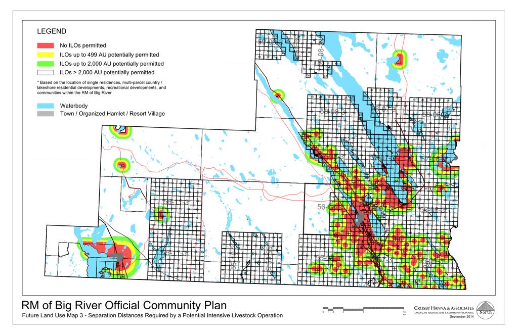
4 A total of 1.1% of the total land in the municipality is identified as Prime Farmland in terms of its capability for dryland agricultural production for common field crops. Roughly 13% of the land base is classified as Moderate. Due to the small amount of prime farmland in the RM, protecting it from being unnecessarily taken out of production for non -agricultural uses is an important consideration. Protection of agricultural activities and resources is a priority for the municipality. Council encourages the retention of high quality agricultural land in larger parcels where appropriate to avoid the fragmentation of productive land. Flexibility in terms of site size for agricultural development should be considered in order to accommodate development of intensive agriculture, small scale farms, farm diversification and agricultural innovation. Agricultural Land Use & Development Accommodate traditional forms of dry-land crop production and associated uses through the Agricultural Zoning District in the Zoning Bylaw. Encourage and provide for, in the Zoning Bylaw as discretionary uses, further development and land uses that result in economic diversification, innovation, and agricultural valueadded activity. It is recognized that farm based businesses and on-farm employment opportunities, including bed and breakfast establishments, vacation farms, etc., can provide a valuable contribution to the diversified economic base of the municipality. Farm based businesses shall be listed as discretionary uses in the Zoning Bylaw. The area within the Provincial Forest is largely Crown Land, administered by the Saskatchewan Ministry of Environment. The primary uses of this land are natural resource harvesting, including forestry, wild plant harvesting, fish harvesting, wild game management and recreational hunting and angling. These activities are regulated by provincial legislation. Within this area, mineral and aggregate exploration and extraction may take place depending on the location of the resources. This is controlled through provincial environmental impact assessment, leasing and permit legislation and processes. Council recognizes that as long as these activities do not involve sale of land to private persons, land subdivision, development of roads that will be a municipal responsibility, or conflict with adjacent agricultural use of land, the regulations, policies and processes administered by the Ministry of Environment are sufficient to deal with municipal land concerns. Forest To recognize the natural and scenic significance of the RM of Big River and to promote its conservation and preservation in order that this resource may be preserved and managed for natural habitat and for the use of enjoyment of future generations. Council will consider the impacts of development in the Big River region and its many waterbodies, and cooperate with adjoining rural municipalities, urban municipalities, First Nations, Prince Albert National Park and provincial recreation sites in achieving preservation of natural areas to the greatest extent possible. Intensive Livestock Operations will be allowed only under specific regulatory and locational criteria (such as separation distances from dwellings) and subject to the discretionary use process.


 needs to be considered as development continues to increase.")
5 Residential Land Use & Development Field investigations in the Spring of 2014 identified a total of 530 occupied residences within the RM of Big River (Statistics Canada: 305 in 2011). This 200+ dwelling discrepancy is likely due at least in part to the increased popularity of country/lakeshore residential development over the last 3 years. There are approximately 20 country/lakeshore residential subdivisions within the RM. These subdivisions range in size and density, and some contain other amenities such as marinas, boat launches, campgrounds, beaches, playgrounds and the like. Trailer coach or park model subdivisions exist throughout the municipality and should be accommodated through specific zoning districts. The popularity of country/lakeshore residential development in the RM is increasing rapidly, with large year-round homes becoming more commonplace. Policies related to this type of development (e.g. unique servicing needs) needs to be considered as development continues to increase. A maximum of two (2) single-parcel country residential subdivisions per quarter section will be permitted in the A- Agriculture District without a rezoning. Maximum and minimum site sizes and other regulations for both single parcel, multi-parcel country residential and lakeshore residential development will be prescribed by the Zoning Bylaw at various densities. Docks shall not require a development permit but must conform to all provisions of the OCP and ZB, and all other relevant municipal, provincial and federal regulations. Docks may also require prior approval from the Saskatchewan Water Security Agency if riparian or shoreline habitat alteration work is required. Boat houses and docks shall not be located or partially located within Municipal Reserve or Environmental reserve. Multi-parcel country residential development will only be supported where infrastructure, utility systems and services have adequate capacity. In the interests of ensuring a comprehensive and planned approach to development, the RM may require a developer to prepare a Comprehensive Development Application for proposed country / lakeshore residential developments to address land use integration, as well as all engineering and environmental matters. Commercial & Industrial Land Use The RM is home to a number of forestry, lumber and forestry-related industrial developments including Carrier Forest Products (Saskatchewan s largest sawmill), Christiansen Lumber and other operations. Local commercial services for residents of the RM are mostly found within the Town of Big River, although some commercial uses are located in the RM including Trailrunners Pet Resort, LFE Motorsports, Clearwater Greenhouses and other establishments including home based businesses. There are a number of intensive agricultural/horticultural operations in the RM including greenhouses and tree nurseries. Accommodate commercial and industrial land uses in existing nodes and new locations while avoiding land use conflicts. Commercial and industrial development is encouraged to locate along existing primary transportation corridors. In the interests of ensuring a comprehensive and planned approach to development, the RM may require a developer to prepare a Comprehensive Development Application for proposed commercial / industrial developments to address land use integration, as well as engineering and environmental matters.


6 Recreation & Tourism The RM of Big River is a very popular recreation destination for visitors and residents alike. Its prime location in north-central Saskatchewan, with its many waterbodies, forest areas, and interesting topography provides for countless recreational opportunities year-round. There are several Recreation Sites within the municipality, including Chitek Lake, Shell Lake, Bug Lake, Island Lake, Hackett Lake, Delaronde Lake (Zig Zag Bay), Top Lake, Nesslin Lake and Ness Lake. These lakes offer camp sites, boat launches, beaches, angling opportunities and related amenities. The Town of Big River owns a golf course located within the RM which is leased to the Big River Golf Club, east of the Town. The Chitek Lake golf course is also located within the RM. There are several music and cultural festivals hosted within the RM, including the popular Ness Creek Music Festival, which attracts thousands of visitors from all over the world, every summer for the last 25 years, to a site on the north bank of Ness Creek. The RM of Big River will favourably consider responsible lake-oriented development that protects and conserves lakeshore features and landscapes and considers the integration of compatible land use activities with environmental protection measures. The RM of Big River will continue to collaborate with the Town of Big River in providing recreational amenities and opportunities for the area, and seek out mutually beneficial opportunities with other organizations and authorities in the interest of promotion, preservation and enhancement of recreation and tourism in the region.

7 Future Land Use Maps The Future Land Use Maps consist of maps within the OCP (see next panels) that are intended to guide land use decisions within the municipality by identifying opportunities and constraints on future land use and development. Council will consider new subdivision and development proposals in the context of the information contained on the Future Land Use Maps, which form part of the Official Community Plan. The Future Land Use Maps are as follows: Map 1: Preferred Transportation Corridors Identifies key transportation corridors that could potentially support future development with the least amount of new road infrastructure. Map 2: Soil Capability for Agriculture Identifies the capability of land for dry land crop production. Map 3: Separation Distances Required for a Potential ILO Identifies existing development and the buffer distances required for an ILO from this existing development. Map 4: Development Constraints Identifies development constraints such as potential heritage sensitivity, waterbodies and wetlands, existing ILOs, potential critical wildlife habitat, recreation sites, and the urban-rural fringe. Map 5: Digital Elevation Model Identifies graphically the elevation in metres above sea level of all of the land within the municipality. Implementation (The Zoning Bylaw) The Zoning Bylaw will be the primary method of implementing the objectives and policies contained in the Official Community Plan. It will establish zoning districts for residential, agricultural, commercial, and industrial land uses. These districts will regulate types of land uses, site sizes, setbacks, etc.
8
9

10 ZONING BYLAW Zoning Districts The zoning districts contained in the RM of Big River Zoning Bylaw are intended to designate land uses to appropriate areas within the boundaries of the Municipality, and to regulate and standardize the development of those land uses. The zoning districts and their intents are as follows: A Agriculture District To provide for the primary use of land in the form of agricultural development, associated residences, limited single-parcel country residential development, associated residences, location-dependent natural resource development and other uses compatible with agricultural development Site size minimum: 1.0 ha (2.47 acres). F Forest District To provide for the management of extensive areas of forested Crown Land using sound integrated resource management principles and techniques and recognizing a wide variety of resources and other uses. CR1 Low Density Country Residential District To provide for low density, multiple-lot country residential development and other compatible development in specific areas with standards for such development which does not directly support agriculture. Site size minimum: 4.04 ha (9.98 acres) to a maximum of 8.08 ha (20 acres). CR2 Medium Density Country Residential District To provide for medium density, multiple-lot country residential development and other compatible development in specific areas with standards for such development which does not directly support agriculture. Site size minimum: 0.8 ha (1.98 acres) to a maximum of 3.99 ha (9.86 acres). CR3 High Density Country Residential District To provide for high density, multiple-lot country residential development and other compatible development in specific areas with standards for such development which does not directly support agriculture. Site size minimum: 0.2 ha (0.49 acres) to a maximum of 0.79 ha (1.95 acres). LR1 Medium Density Lakeshore Residential District To provide for medium density residential development and other compatible development in specified areas with standards for such development. Site size minimum: 1,115 m 2 (12,000 ft 2 ). LR2 High Density Lakeshore Residential District To provide for high density residential development and other compatible development in specified areas with standards for such development. Site size minimum: 450 m 2 (4,843.8 ft 2 ). RPM Park Model Residential District To provide for comprehensively planned park model trailer residential development and other compatible uses. Site size minimum: 1,150 m 2 (12,379 ft 2 ). C1 Resort Commercial District To provide for resort commercial development and other compatible development in specific areas, with standards for such development. Site size minimum: 10,000 m 2. C2 Highway Commercial District To provide for general commercial development and other compatible development in specific areas, with standards for such development. Site size minimum: 1,000 m 2 (10,764 ft 2 ). M Industrial District To provide for light industrial, heavy industrial and other compatible development in specific areas, with standards for such development. Site size minimum: 4,000 m 2 (43,056 ft 2 ).
OFFICIAL COMMUNITY PLAN
 BYLAW NO. 2018-09 OFFICIAL COMMUNITY PLAN ABSTRACT The purpose of an Official Community Plan (OCP) is to provide a comprehensive policy framework to guide the physical, economic, social and cultural development
Table of Contents. Introduction...1. Servicing Regional Vision...5. Governance and Implementation General Policies Glossary...
 MAY 2017 DRAFT Table of Contents Introduction....1 Servicing....57 The Saskatoon North Partnership for Growth 3 Plan Area 3 Plan Contents 3 Regional Vision....5 Vision 7 Principles 8 Strategic Directions
Oldman River Reservoir
 MUNICIPAL DISTRICT OF PINCHER CREEK NO. 9 Oldman River Reservoir AREA STRUCTURE PLAN Bylaw No. 1120-06 Prepared by the OLDMAN RIVER REGIONAL SERVICES COMMISSION September 2007 Table of Contents Page PART
Planning and Development in Saskatchewan. Community Planning Branch Ministry of Government Relations
 Planning and Development in Saskatchewan Community Planning Branch Ministry of Government Relations Today s Discussion Overview of Planning Legislation & Regulations Planning Bylaws Importance of Planning
A Guide to the Municipal Planning Process in Saskatchewan
 A Guide to the Municipal Planning Process in Saskatchewan An overview of the municipal planning, development permit and the subdivision approval processes in Saskatchewan July 2016 Prepared By: Community
Town of Huntsville Official Plan Section 9 Rural Area Page 104
 Section 9 Rural Area Page 104 9 RURAL AREA 9.1 Definition and Function Location Rural Settlements 9.1.1 The Rural Area includes those lands located outside any other land use designation identified in
County of Wetaskiwin Pigeon Lake Watershed Area Concept Plan February 6, 2014
 County of Wetaskiwin Pigeon Lake Watershed Area Concept Plan February 6, 2014 1 Introduction 1.1 Background The Pigeon Lake area continues to attract significant attention from landowners wanting to pursue
REGIONAL GROWTH STRATEGY
 THOMPSON-NICOLA REGIONAL DISTRICT REGIONAL GROWTH STRATEGY Bylaw 2409, 2013 Source: Picture BC Thompson-Nicola Regional District 300-465 Victoria Street Kamloops, BC V2C 2A9 Telephone: 1-250-377-8673 Toll
Municipal Development Plan Bylaw 818/96
 Municipal Development Plan Bylaw 818/96 Consolidated version for administrative purposes only Contains amendments up to and including March 30, 2010 Table of Contents Sturgeon County Municipal Development
Sustainable Natural Environment Fish Habitat
 Town of Huntsville Official Plan Review - POLICY BACKGROUND PAPER Sustainable Natural Environment Fish Habitat BACKGROUND: Lakes, rivers, streams, ponds and many wetlands provide fish habitat. Intermittent
INTERMUNICIPAL DEVELOPMENT PLAN. Ponoka County / Town of Rimbey PONOKA COUNTY BYLAW NO IDP TOWN OF RIMBEY BYLAW NO. 954/19
 INTERMUNICIPAL DEVELOPMENT PLAN Ponoka County / Town of Rimbey PONOKA COUNTY BYLAW NO. 8-19-IDP TOWN OF RIMBEY BYLAW NO. 954/19 MARCH 20, 2019 Page 2 of 18 TABLE OF CONTENTS TABLE OF CONTENTS... 2 A. INTRODUCTION...
COUNTY COMPREHENSIVE PLAN
 86 : Policy Statement Lewis County has an abundance of natural resources, including water, wind, soils, and wildlife. Together with our citizens, they form a unique ecosystem that must be preserved and
Town of Eckville/Lacombe County INTERMUNICIPAL DEVELOPMENT PLAN DRAFT ADOPTED: INSERT DATE
 Town of Eckville/Lacombe County INTERMUNICIPAL DEVELOPMENT PLAN ADOPTED: INSERT DATE www.lacombecounty.com (403) 782-8389 planning@lacombecounty.com www.eckville.com (403) 746-2171 info@eckville.com For
Lincoln - OFFICIAL PLAN APPENDIX 1 DEFINITIONS
 Lincoln - OFFICIAL PLAN APPENDIX 1 DEFINITIONS Where a term used in this Plan, or a definition in this Section, is inconsistent with a definition in the Provincial Policy Statement or Provincial Plan,
Town of Eckville/Lacombe County INTERMUNICIPAL DEVELOPMENT PLAN
 Town of Eckville/Lacombe County INTERMUNICIPAL DEVELOPMENT PLAN ADOPTED: APRIL 23, 2018 www.lacombecounty.com (403) 782-8389 planning@lacombecounty.com www.eckville.com (403) 746-2171 info@eckville.com
CITY OF YORKTON BYLAW NO. 13/1994
 CITY OF YORKTON BYLAW NO. 13/1994 Disclaimer: This information has been provided solely for research convenience. Official bylaws are available from the Office of the City Clerk and must be consulted for
Bylaw SUMMER VILLAGE OF WHITE SANDS Buffalo Lake Intermunicipal Development Plan 2015
 Bylaw 151-15 SUMMER VILLAGE OF WHITE SANDS Buffalo Lake Intermunicipal Development Plan 2015 Photo taken by Mason George BUFFALO LAKE INTERMUNICIPAL DEVELOPMENT PLAN AUGUST 2015 1.0 INTRODUCTION... 1 1.1
BYLAW Summer Village of Rochon Sands Buffalo Lake Intermunicipal Development Plan 2015
 BYLAW 220-15 Summer Village of Rochon Sands Buffalo Lake Intermunicipal Development Plan 2015 BUFFALO LAKE INTERMUNICIPAL DEVELOPMENT PLAN Summer Village of Rochon Sands AUGUST 2015 1.0 INTRODUCTION...
Electoral Area F Official Community Plan Schedule A. February 1, 2016
 Electoral Area F Official Community Plan Schedule A February 1, 2016 Table of Contents 1. INTRODUCTION... 5 1. Forward... 5 2. Goal Statement... 5 3. Plan Area Context... 5 4. Population Overview... 6
Green Infrastructure: A Guide to Asset Mapping in the Rappahannock-Rapidan Region. Rappahannock-Rapidan Regional Commission December 2015
 Green Infrastructure: A Guide to Asset Mapping in the Rappahannock-Rapidan Region Rappahannock-Rapidan Regional Commission December 2015 What Is Green Infrastructure? Green infrastructure is an interconnected
14. Sustainable Forestry Principals
 14. Sustainable Forestry Principals Fish River Lakes Concept Plan Addendum Materials April 2018 14. SUSTAINABLE FORESTRY PRINCIPLES In response to our discussion with LUPC Staff and others on the topic
The Fish River Chain of Lakes Concept Plan
 The Fish River Chain of Lakes Concept Plan Overview and Summary December 2014 THE FISH RIVER CHAIN OF LAKES The Fish River chain of lakes in northern Aroostook County is as special as any place in the
The Fish River Chain of Lakes Concept Plan
 The Fish River Chain of Lakes Concept Plan Overview and Summary May 2017 THE FISH RIVER CHAIN OF LAKES THE CONCEPT PLAN The Fish River chain of lakes in northern Aroostook County is as special as any place
Agriculture and farm related businesses and industries are important economic generators for the local and regional community.
 SECTION 3: LAND USE POLICIES - AGRICULTURE Lands designated Agriculture are areas with highly valued soils in accordance with the CLI mapping and therefore have potential for agricultural production, areas
NOT PART OF BY-LAW NO. 1589, Willow River-Upper Fraser Valley Official Community Plan. Table of Contents. Section No.
 NOT PART OF BY-LAW NO. 1589, 1996 Willow River-Upper Fraser Valley Official Community Plan Table of Contents Section No. Section Name Page 1.0 GENERAL PROVISIONS 1 1.1 Purpose of Plan 1 1.2 Jurisdiction
The District of Salmon Arm 1 Agricultural Area Plan Summary
 The District of Salmon Arm 1 Agricultural Area Plan Summary City of Salmon Arm Statistics 2 : Population (2006) 16,012 Jurisdictional Area: City Plan Study Area ALR in Study Area Total Area Farmed (2006)
FORT ST. JAMES RURAL OFFICIAL COMMUNITY PLAN
 FORT ST. JAMES RURAL OFFICIAL COMMUNITY PLAN BYLAW No. 1578, 2010 Schedule A Regional District of Bulkley-Nechako PLANNING DEPARTMENT 37 3 RD AVENUE PHONE (250) 692-3195 P.O. BOX 820 TOLL-FREE (800) 320-3339
Official Plans. Zoning By-laws. Site Plan Control Development Approvals and Agreements. Figure 28 Municipal Planning Tools
 Section 7 The purpose of this section is to identify known future growth areas in the Town of Huntsville and describe the municipal planning documents and regulations that apply to Lake Vernon in order
ATTACHMENT 2A- Issues Tentatively Resolved Decisions from the Board of Supervisors Hearing on September 11, 2007
 1. Introduction (on pg 1-15) Add the following goal: A Community safe from climate change. Marin will be a leader in averting and adapting to aspects of climate change. 2. Biological Resources 2.A. Richardson
Provincial Policy Statement 2014 Training Aid
 This job aid has been developed for education and training purposes as a high-level summary of the policy changes in the PPS 2014. It should not be relied upon as a substitute for specialized legal or
OFFICIAL PLAN FOR THE MUNICIPALITY OF MAGNETAWAN
 OFFICIAL PLAN FOR THE MUNICIPALITY OF MAGNETAWAN Prepared by July 24, 2002 May 16, 2005 and June 14, 2005 With Jim s Notes on Modifications Modifications provided by MMAH on May 10, 2005 and June 8, 2005
AREA STRUCTURE PLAN SW W4M CAMROSE COUNTY BYLAW ## JULY 2017(REVISED) PREPARED BY: AUSTROM CONSULTING &VICINIA PLANNING & ENGAGEMENT INC.
 PREPARED BY: AUSTROM CONSULTING &VICINIA PLANNING & ENGAGEMENT INC.") AREA STRUCTURE PLAN SW 33-46-19-W4M CAMROSE COUNTY BYLAW ## JULY 2017(REVISED) PREPARED BY: AUSTROM CONSULTING &VICINIA PLANNING & ENGAGEMENT INC. Table of Contents 1. Purpose... 2 2. Policy Context...
AREA STRUCTURE PLAN SW 33-46-19-W4M CAMROSE COUNTY BYLAW ## JULY 2017(REVISED) PREPARED BY: AUSTROM CONSULTING &VICINIA PLANNING & ENGAGEMENT INC. Table of Contents 1. Purpose... 2 2. Policy Context...
TABLE OF CONTENTS 5.0 FOREST MANAGEMENT PLANNING...
 TABLE OF CONTENTS 5.0 FOREST MANAGEMENT PLANNING... 1 5.1 Planning Framework... 1 5.1.1 Sustainable Forest Management Planning... 1 5.1.2 Five-Year Operating Plan... 1 5.1.3 Annual Operating Plans... 3
Miquelon Lake Area Structure Plan
 Camrose County 1 928-01-00 Table of Contents 1 Introduction... 3 1.1 Background... 3 1.2 Purpose... 3 1.3 Location and Ownership... 3 2 Background... 6 2.1 Policy Context... 6 2.1.1 Provincial Policy Direction...
SUMMARY OF MAJOR POLICY IMPLEMENTATION TOPICS From 2016 COUNTY Comprehensive Plan
 SUMMARY OF MAJOR POLICY IMPLEMENTATION TOPICS From 2016 COUNTY Comprehensive Plan A checkmark means that implementing code amendments have been drafted or are in progress as of November 1, 2016. Evaluate
Lincoln - OFFICIAL PLAN PART 1 INTRODUCTION 1.1. THE COMMUNITY VISION
 Lincoln - OFFICIAL PLAN PART 1 INTRODUCTION 1.1. THE COMMUNITY VISION The vision for Lincoln is to be a Centre of Excellence for Agriculture; an inclusive community that values diversity, partnerships,
OFFICIAL PLAN. Office Consolidation
 OFFICIAL PLAN Office Consolidation As approved by the Ministry of Municipal Affairs and Housing (December 17, 2012) and Ontario Municipal Board (August 4, 2016) and As amended by Official Plan Amendments
Model Riparian Buffer Ordinance.
 Model Riparian Buffer Ordinance. This is a sample riparian buffer ordinance written as an amendment to an existing zoning ordinance. This ordinance complies with the state minimum standards for river corridor
Regional Watersheds Advisory Board. September 20, 2017
 Regional Watersheds Advisory Board September 20, 2017 Agenda Definitions Policy Framework (general overview) Watershed Planning Regulations (in detail) 2 Definitions Policy - A statement of intent Land
SAUGEEN CONSERVATION Year in Review
 2007 Year in Review 111 Our Lands Our Treasures Our Future! Over 21,000 Acres of Natural Treasures Something to be proud of! 112 WHAT DO OUR LANDS DO FOR US? A) Recreational Opportunities/ & Impact to
ENVIRONMENTAL PLANNING POLICIES Draft September 2014
 Draft September 2014 Document No. Rev. 2 draft Date 09/22/14 (mm/dd/yy) Document Revisions Revision Date (mm/dd/yy) Description of changes 0 03/29/95 Original Issue (Adopted by Full Authority Resolution
CITY POLICY POLICY NUMBER: C531 REFERENCE: ADOPTED BY: City Council Council July 2007 SUPERSEDES: Policy C467
 CITY POLICY REFERENCE: ADOPTED BY: City Council Council 1995 07 25 17 July 2007 SUPERSEDES: Policy C467 PREPARED BY: Office of Natural Areas DATE: 5 June 2007 Policy Statement: Since Edmonton was settled
Municipal Class EA Process
 Purpose of Tonight s Meeting INTRODUCTION This is the first Public Information Centre (PIC) to present information on the Class Environmental Assessment (EA) Study for a new operations centre. The following
Maple Ridge Official Community Plan Policies that Support Community Greenhouse Gas Emissions Reduction
 Maple Ridge Official Community Plan Policies that Support Community Greenhouse Gas Emissions Reduction Transportation & Land-Use Sector Reduce transportation related energy use through compact communities,
Network utilities, subject to compliance with Part 6 (Infrastructure) A.3 Existing vegetation cover.
 A.3 Existing vegetation cover.") 5.3.2. Rural Zone 5.3.2.1. Permitted Activities 5.3.2.1.1. Residential, recreational, agricultural, exotic forestry or tourist related activities which comply with the standards for permitted activities
5.3.2. Rural Zone 5.3.2.1. Permitted Activities 5.3.2.1.1. Residential, recreational, agricultural, exotic forestry or tourist related activities which comply with the standards for permitted activities
DRAFT Miquelon Lake Growth Management Study Camrose County
 DRAFT Miquelon Lake Growth Management Study Camrose County 928-01-00 1 Table of Contents1... Introduction 1 1.1 Background... 1 1.2 Purpose... 1 1.3 Location and Ownership... 1 2 Background... 4 2.1 Policy
11. Prioritizing Farmlands for Future Protection
 11. Prioritizing Farmlands for Future Protection Identification of Important Farmlands in Putnam County I n order to implement this Plan successfully, Putnam County decision-makers will have to take advantage
Yamhill County Comprehensive Land Use Plan
 Yamhill County Comprehensive Land Use Plan Revised Goals And Policies - Adopted December 30, 1996 Incorporating Goal and Policy amendments through Ordinance 618 SECTION II. The Land and Water A. Agricultural
Wildlife Management Area
 Proposed Wildlife Management Area A wildlife management area designation is being proposed for the Harrison-Chehalis area to conserve fish and wildlife habitats while also respecting existing and compatible
Agricultural Economic Development Plan
 Agricultural Economic Development Plan (Agricultural and Farmland Protection Plan) and Farmland Protection Board Shepstone Management Company Cornell Cooperative Extension of Broome County Broome County
2. That the Big Mountain lndustrial Park Area Structure Plan, attached hereto as Schedule A, is. 3. That Bylaw No is hereby repealed.
 BYLAW NO. 18-793 of the Municipal District of Greenview No. 15 A Bylaw of the Municipal District of Greenview No. 16, in the Province of Alberta, for adopting Bylaw L8'793, being the Big Mountain lndustria!
Vision, Goals, Objectives, and Land Use Scenarios Welcome
 Vision, Goals, Objectives, and Land Use Scenarios Welcome Event purpose is to: 1. present draft land use scenarios, as well as the vision, goals and objectives. 2. provide a project update and the next
This policy discussion paper has been prepared for the Town of Whitby by Meridian Planning Consultants with the assistance of GLPi.
 table of contents 1.0 INTRODUCTION... 2 2.0 LOCATION OF AGRICULTURAL AREA IN WHITBY... 3 3.0 THE STATE OF AGRICULTURE IN WHITBY... 5 4.0 PROVINCIAL POLICY AND AGRICULTURE... 9 4.1 Provincial Policy Statement...
NOTICE OF PUBLIC HEARING BYLAW 1413
 NOTICE OF PUBLIC HEARING BYLAW 1413 Pursuant to Section 631 of the Municipal Government Act, the Council of Camrose County gives notice that they have given First Reading to Camrose County By-law 1413
PRINCE GEORGE NATURAL AREAS AND THE EFFECTS OF CLIMATE CHANGE: CASE STUDY
 PRINCE GEORGE NATURAL AREAS AND THE EFFECTS OF CLIMATE CHANGE: CASE STUDY Natural Areas in Prince George The City of Prince George is dominated by natural, undeveloped areas within city limits and in adjacent
PRESENTED: March 27th th, 2007 FILE: Bylaw No FROM: Planning Department
 DISTRICT OF SQUAMISH REPORT TO: Council FOR: Regular PRESENTED: March 27th th, 2007 FILE: 2005-21 Bylaw No. 1873 FROM: Planning Department SUBJECT: Bylaw No. 1873 Logger s Lane Small Lot Residential Recommendation:
REGIONAL DISTRICT OF NORTH OKANAGAN. BYLAW No. 2702
 REGIONAL DISTRICT OF NORTH OKANAGAN BYLAW No. 272 A bylaw of the Regional District of North Okanagan to adopt an Official Community Plan for Electoral Area F WHEREAS pursuant to Section 472 [Bylaw to adopt
WELCOME. Hwy 28 & Hwy 41 Major Area Structure Plan. Purpose of the Open House:
 WELCOME Hwy 28 & Hwy 41 Major Area Structure Plan Purpose of the Open House: To present the Draft Hwy 28 and Hwy 41 Major Area Structure Plan (MASP) Get your comments and feedback on the Draft MASP Provide
Not Part of Bylaw No Tabor Lake-Stone Creek Official Community Plan
 Not Part of Bylaw No. 2157 Tabor Lake-Stone Creek Official Community Plan TABLE OF CONTENTS SCHEDULE A Section No. Section Name Page 1.0 GENERAL PROVISIONS 1 1.1 Purpose of Plan 1 1.2 Jurisdiction 2 1.3
Chapter 8 Natural Resources
 Chapter 8 Natural Resources 127-134 8.1 Introduction 8.2 Extractives Industry 8.3 Forestry 8.4 Fishing / Aquaculture 8.1 Introduction Kerry has a number of naturally occurring resources that contribute
Community Benefits of Land Restoration
 Community Benefits of Land Restoration Introducing Green Infrastructure for Coastal Resilience Matt Fulda, Acting Director Monroe May 23 rd, 2017 Avery Point Campus, University of Connecticut Easton Trumbull
CHAPTER 7: SHORELINE DESIGNATIONS
 CHAPTER 7: SHORELINE S Introduction Shoreline Designations are intended to encourage uses and activities that will protect or enhance the present or desired character of a shoreline and allow appropriate
STAFF REPORT. Permit Number: Tallman. Kitsap County Board of Commissioners; Kitsap County Planning Commission
 STAFF REPORT Permit Number: 15 00742 Tallman DATE: November 9, 2015 TO: FROM: RE: Kitsap County Board of Commissioners; Kitsap County Planning Commission Katrina Knutson, AICP, Senior Planner, DCD and
LOWER DRUM PLANNING UNIT Yuba-Bear River Watershed
 Existing Conditions & Uses Overview Provides open space and recreation opportunities within the Sierra Nevada foothills 1,098 acres in Placer and Nevada Counties 789 acres outside the FERC boundary; 309
CHAPTER 8: ENVIRONMENTAL MANAGEMENT POLICIES
 TOWNSHIP OF WELLESLEY OFFICIAL PLAN page 74 of 133 CHAPTER 8: ENVIRONMENTAL MANAGEMENT POLICIES Jurisdiction over environmental matters is divided among different levels of government. Effective environmental
STRUCTURES: File No There is a dwelling, a 14ft mobile home and storage shed, a garage/shop, barn, chicken coop, dog kennel, and roping arena.
 PEACE RIVER REGIONAL DISTRICT DEVELOPMENT SERVICES REPORT ON SUBDIVISION WITHIN THE AGRICULTURAL LAND RESERVE R-16 OWNER: Kari & Jonathan Bondaroff DATE: May 11, 2018 AREA: Electoral Area D FILE NO. 18-070
APPENDIX A REVIEW OF NATURAL HERITAGE SYSTEM POLICIES AND MAPS
 APPENDIX A REVIEW OF NATURAL HERITAGE SYSTEM POLICIES AND MAPS MARCH 16, 2017 TABLE OF CONTENTS A1. NHS POLICY IN THE ROP... 3 A2. RNHS POLICY IN THE ROP... 3 A3. CONSTRAINTS TO DEVELOPMENT IN THE GREENBELT
Fish Habitat Protection Development Permit Area
 Appendix A2 3 Fish Habitat Protection Development Permit Area 1.0 PURPOSE: The area shown on Map No. 7 as the Fish Habitat Protection Development Permit Area is designated for the purpose of protecting
Introduction to the Riparian Areas Regulation
 Information Note #1: Introduction to the Riparian Areas Regulation This Information Note is a guide only. It is not a substitute for the federal Fisheries Act, the provincial Riparian Areas Regulation,
Town of Saratoga. Agriculture and Farmland Protection Plan
 Town of Saratoga Agriculture and Farmland Protection Plan EXECUTIVE SUMMARY Town of Saratoga Saratoga County, New York September 2018 Executive Summary Dramatic Changes in the Agricultural Landscape In
District of Muskoka Planning and Economic Development Department. Lake of Bays Association Executive Committee
 Date: November 10, 2017 To: From: C.C. District of Muskoka Planning and Economic Development Department Lake of Bays Association Executive Committee Lake of Bays Association Board of Directors Township
CHAPTER 7.0 AGRICULTURAL ELEMENT
 CHAPTER 7.0 AGRICULTURAL ELEMENT Monterey County has elected to include an Agricultural Element as part of the General Plan. Agriculture consisting of crop farming and livestock grazing is the largest
Town of Saratoga. Agriculture and Farmland Protection Plan. Town of Saratoga
 Town of Saratoga Agriculture and Farmland Protection Plan Town of Saratoga Saratoga County, New York December 2018 Executive Summary Dramatic Changes in the Agricultural Landscape The face of agriculture
VEGETATIVE, WATER, FISH AND WILDLIFE RESOURCES POLICIES
 VEGETATIVE, WATER, FISH AND WILDLIFE RESOURCES POLICIES The County will: GOALS AND OBJECTIVES 1.1 Conserve, Enhance, Protect, Maintain and Manage Vegetative, Water, Fish and Wildlife Resources Promote
Policy NR Maintain the natural and functional characteristics of Portsmouth s soils. (Related Policies: AG 1.1, LU 6.2)
") PORTSMOUTH DRAFT COMPREHENSIVE COMMUNITY PLAN POLICY STATEMENTS SUMMARY 1 NATURAL RESOURCES Policy NR - 1.1 - Ensure that new development and redevelopment in Portsmouth takes place in a manner which protects
PORTSMOUTH DRAFT COMPREHENSIVE COMMUNITY PLAN POLICY STATEMENTS SUMMARY 1 NATURAL RESOURCES Policy NR - 1.1 - Ensure that new development and redevelopment in Portsmouth takes place in a manner which protects
COMMUNITY OF NORTH SHORE 2014 OFFICIAL PLAN JANUARY 8TH, 2014 VISION
 COMMUNITY OF NORTH SHORE 2014 OFFICIAL PLAN JANUARY 8TH, 2014 VISION The Community of North Shore will continue to grow around core occupations of agriculture, fishing and tourism, and as a diverse and
Adapting to Climate Change in Kimberley, BC. Executive Summary June Prepared by Ingrid Liepa
 Adapting to Climate Change in Kimberley, BC Executive Summary June 2009 Prepared by Ingrid Liepa Executive Summary The City of Kimberley was selected by the Columbia Basin Trust (CBT) in April 2008 as
C O N T E X T. A VISION FOR THE UPPER LANDS (Excerpt from June 2001 Upper Lands Report)
") C O N T E X T West Vancouver s forested g visual backdrop for both the community and the region. Planning policies for this 6,265 acre area, known as the Upper Lands, are long term and comprehensive, and
C O N T E X T West Vancouver s forested g visual backdrop for both the community and the region. Planning policies for this 6,265 acre area, known as the Upper Lands, are long term and comprehensive, and
Lac Sante Area Structure Plan
 2010 Lac Sante Area Structure Plan County of St. Paul No. 19 Google.com BYLAW NO. 1542 October 2010 LAC SANTE AREA STRUCTURE PLAN BYLAW NO. 1542 WHEREAS pursuant to the Municipal Government Act, R.S.A.
City of Surrey Agricultural Plan Summary
 City of Surrey Agricultural Plan Summary City of Surrey Statistics 1 : Population (2006) 364,976 Jurisdictional Area: Land Water Total Total Area Farmed (2006) 31,837 ha 4,610 ha 36,447 ha 9,307 ha % of
Minnesota s Alternative Shoreland Management Standards
 Minnesota s Shoreland Management Standards In summary, the Standards include, but are not limited to: Multiple shoreland lake classifications on a single lake, for example, a natural environment bay of
District of Muskoka Official Plan Draft October 5, 2017
 Made in Muskoka District of Muskoka Official Plan Draft October 5, 2017 A land use and community development plan based on the principles of sustainability and recognizing the unique context of the District
BACKGROUND. Public Opinion Survey Results: December 2013 Page 2
 THE PROVINCE OF PRINCE EDWARD ISLAND Public Opinion Survey Results: December 2013 Task Force on Land Use Policy Aubin Arsenault Building3 Brighton Road, Charlottetown, PE C1A 7N8Tel: (902) 620 3558Fax:
Natural Systems Planning Primer
 Natural Systems Planning Primer Lise.Guevremont@ottawa.ca Amy.Macpherson@ottawa.ca Land Use and Natural Systems Unit Planning and Growth Management November 2015 1 Welcome Policy Framework Development
Provincial. Statement
 Provincial Statement This publication was produced by the Ministry of Municipal Affairs and Housing. For more copies of this document, in either English or French, please contact: Publications Ontario
The following recommendations will need to be re-evaluated given the recent fire at the Kennedy Meadows Pack Station.
 Kennedy Meadows Planning Unit The following recommendations will need to be re-evaluated given the recent fire at the Kennedy Meadows Pack Station. Sustainable Forestry Evaluate existing timber inventory
Draft Official Plan presented to Committee of the Whole on November 24, 2017 Held an information session with local municipal staff and agency staff
 Draft Official Plan presented to Committee of the Whole on November 24, 2017 Held an information session with local municipal staff and agency staff at the beginning of November to highlight the proposed
Planning Resource Guide. Planning for Agriculture
 Planning Resource Guide Planning for Agriculture The new Provincial Planning Regulation continues to promote sound land use planning and express the provincial interest in the sustainable development of
a. The following regulations shall apply to all guest ranches:
 SECTION 15 GENERAL DEVELOPMENT STANDARDS 15.1 Guest Ranches. a. The following regulations shall apply to all guest ranches: (1) Individual guest ranch quarters shall not contain Kitchen or cooking facilities.
Community Services and Utilities & Environmental Protection Report to UE The SPC on Utilities and Environment Page 1 of April 25
 Community Services and Utilities & Environmental Protection Report to UE2007-15 The SPC on Utilities and Environment Page 1 of 2 2007 April 25 ENVIRONMENTAL RESERVE SETBACKS SUMMARY/ISSUE This report recommends
The Social and Economic Importance of Canada s Privately Owned Forest Lands
 The Social and Economic Importance of Canada s Privately Owned Forest Lands Key Points n Private forests make up 6% of Canada s 402 million ha of forested land and 13% of the managed forest. n Private
District of Maple Ridge Agricultural Land Use Inventory 2004
 Agricultural Land Use Inventory 2004 Prepared by the Ministry of Agriculture, Food and Fisheries October 2004 Table of Contents INTRODUCTION... 2 THE DISTRICT OF MAPLE RIDGE... 2 SURVEY METHOD... 2 LAND
2.4 Description of the No Action and Action Alternatives
 2.4 Description of the No Action and Action Alternatives The alternatives described below represent a range of scenarios that could be implemented at Eufaula Lake to revise shoreline allocations and MP
WATERSHED. Maitland Valley. Report Card 201
 Maitland Valley WATERSHED Report Card 201 The Maitland Valley Conservation Authority has prepared this report card as a summary on the state of our forests, wetlands, surface water, and ground water resources.
Chapter 16: Agriculture
 Chapter 16: Agriculture Introduction and Setting Agriculture has always been an integral part of Nevada County and has continually grown and changed along with the county. The beginning of major agriculture
In the Environment Court of New Zealand Christchurch Registry ENV-2016-CHC- Henley Downs Land Holdings Limited. Appellant. Otago Regional Council
 In the Environment Court of New Zealand Christchurch Registry ENV-2016-CHC- Under In the matter of Between the Resource Management Act 1991 (RMA) an appeal under Clause 14(1), First Schedule of the RMA
Mons Lake Area Structure Plan Bylaw No
 Mons Lake Area Structure Plan Bylaw No. 1216-10 Adopted: March 17, 2011 TABLE OF CONTENTS SMOKY LAKE COUNTY MONS LAKE AREA STRUCTURE PLAN BYLAW NO. 1216-10 TABLE OF CONTENTS... III TABLE OF FIGURES...IV
Environmental Trail Screening Tool. Legislation & Guidelines. Legislation/Guidelines. Implications for Trail Development
 This Legislation & Guidelines Matrix is a resource to accompany the developed by Recreation Sites and s BC. Legislation & Guidelines Legislation/Guidelines Assessment Act Applicability (Federal and Provincial)
For additional copies of this document in either French or English, please contact:
 For additional copies of this document in either French or English, please contact: Ministry of Municipal Affairs and Housing Provincial Planning Policy Branch 777 Bay Street, 14 th Floor Toronto, ON M5G
2. POPULATION, LAND USE, AND SHORELINE DEVELOPMENT IN THE NORTH OLYMPIC COAST STUDY AREA
 2. POPULATION, LAND USE, AND SHORELINE DEVELOPMENT IN THE NORTH OLYMPIC COAST STUDY AREA Clallam County occupies a unique location at the northwest tip of the contiguous United States on the geographically